
Deutsch-Chinesische Enzyklopädie, 德汉百科
 Jilin Sheng-JL

| 文献 | 版本 |
|---|---|
| 《八旗满洲氏族通谱》[3] | 瓜尔佳氏、钮祜禄氏、舒穆禄氏、赫舍里氏、他塔喇氏、觉罗氏、佟佳氏、那拉氏 |
| 《清稗类钞》[4]、《郎潜纪闻初笔》[5]等 | 瓜尔佳氏、钮祜禄氏、舒穆禄氏、纳喇氏、栋鄂氏、马佳氏、伊尔根觉罗氏[註 1]、辉发氏[註 2] |
| 《道咸以来朝野杂记》[8] | 瓜尔佳氏、钮祜禄氏、舒穆禄氏、那拉氏、完颜氏、富察氏、费莫氏、章佳氏 |
| 《庫雅喇氏源流考》[9] | 瓜尔佳氏、钮祜禄氏、觉尔察氏、栋鄂氏、佟佳氏、兆佳氏、伊尔根觉罗氏、他塔拉氏 |
| 《他塔拉氏家譜》[9] | 瓜尔佳氏、钮祜禄氏、赫舍里氏、章佳氏、马佳氏、宁古塔氏、扎拉里氏、伊尔根觉罗氏 |
| 《满族史论丛》[9] | 瓜尔佳氏、钮祜禄氏、舒穆禄氏、纳兰氏、董鄂氏、赫舍里氏、乌拉氏、伊尔根觉罗氏 |
| 京旗民间[10][11] | 瓜尔佳氏、钮祜禄氏、马佳氏、索绰罗氏、齐佳氏、富察氏、那木都鲁氏、佟佳氏 或 瓜尔佳氏、钮祜禄氏、舒穆禄氏、董鄂氏、马佳氏、纳喇氏、索绰罗氏、赫舍里氏 |
| 《兴京县志》、《凤城县志》、东北民间等[12] | 瓜尔佳氏、钮祜禄氏、马佳氏、索绰罗氏(或赫舍里氏)、齐佳氏(或喜塔腊氏)、富察氏、那拉氏、佟佳氏 |
Anhui Sheng-AH
Beijing Shi-BJ
China
Chongqing Shi-CQ
Fujian Sheng-FJ
Gansu Sheng-GS
Gansu Sheng-GS
Guangxi Zhuangzu Zizhiqu-GX
Guizhou Sheng-GZ
Hainan Sheng-HI
Hebei Sheng-HE
Heilongjiang Sheng-HL
Henan Sheng-HA
Hongkong Tebiexingzhengqu-HK
Hubei Sheng-HB
Hunan Sheng-HN
Jiangsu Sheng-JS
Jiangxi Sheng-JX
Jilin Sheng-JL
Liaoning Sheng-LN
Nei Mongol Zizhiqu-NM
Ningxia Huizu Zizhiqu-NX
Qinghai Sheng-QH
Shaanxi Sheng-SN
Shandong Sheng-SD
Shanghai Shi-SH
Shanxi Sheng-SX
Sichuan Sheng-SC
Tianjin Shi-TJ
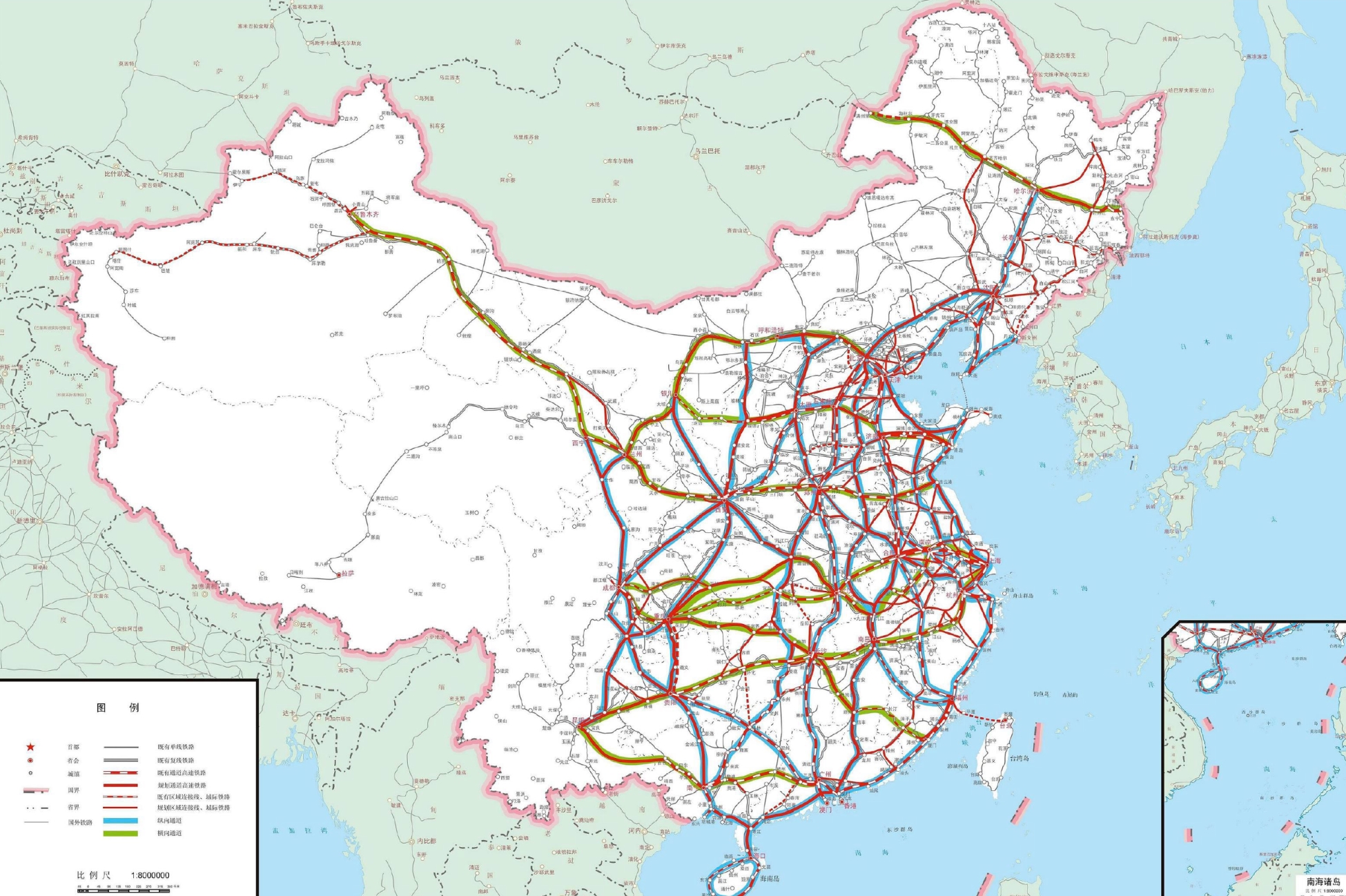
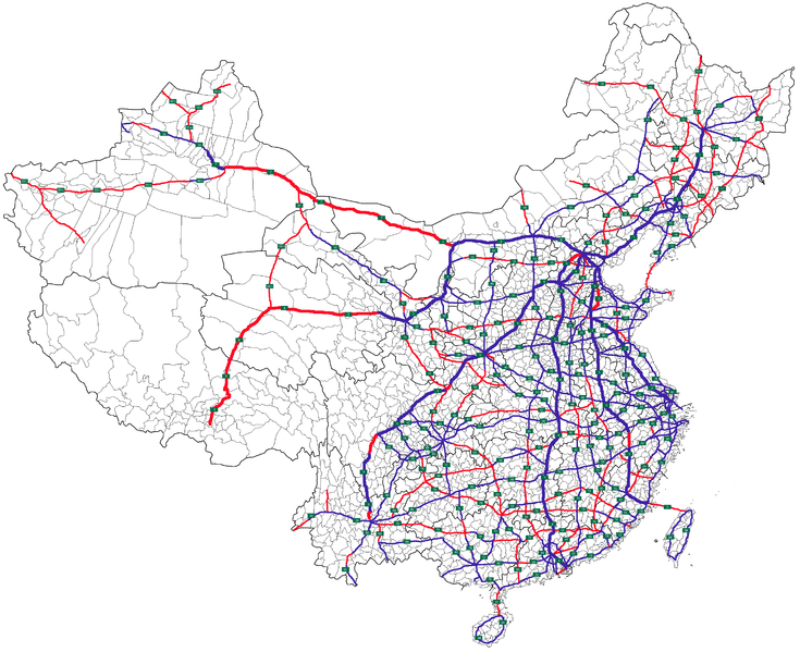
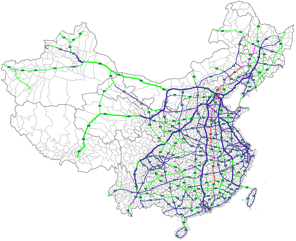
 Transport and traffic
 Railway
Xinjiang Uygur Zizhiqu-XJ
Yunnan Sheng-YN
Zhejiang Sheng-ZJ
Railway
Xinjiang Uygur Zizhiqu-XJ
Yunnan Sheng-YN
Zhejiang Sheng-ZJ
 Anhui Sheng-AH
China
Fujian Sheng-FJ
Guangdong Sheng-GD
Hebei Sheng-HE
Jiangsu Sheng-JS
Jilin Sheng-JL
Liaoning Sheng-LN
Shandong Sheng-SD
Tianjin Shi-TJ
Zhejiang Sheng-ZJ
Anhui Sheng-AH
China
Fujian Sheng-FJ
Guangdong Sheng-GD
Hebei Sheng-HE
Jiangsu Sheng-JS
Jilin Sheng-JL
Liaoning Sheng-LN
Shandong Sheng-SD
Tianjin Shi-TJ
Zhejiang Sheng-ZJ
 Beijing Shi-BJ
China
Guangdong Sheng-GD
Hebei Sheng-HE
Heilongjiang Sheng-HL
Henan Sheng-HA
Hubei Sheng-HB
Jiangxi Sheng-JX
Jilin Sheng-JL
Nei Mongol Zizhiqu-NM
Beijing Shi-BJ
China
Guangdong Sheng-GD
Hebei Sheng-HE
Heilongjiang Sheng-HL
Henan Sheng-HA
Hubei Sheng-HB
Jiangxi Sheng-JX
Jilin Sheng-JL
Nei Mongol Zizhiqu-NM
Der „Autonome Bezirk Yanbian der Koreaner“ liegt im Osten der chinesischen Provinz Jilin an der Grenze zu Nordkorea (DVRK). Seine Hauptstadt ist Yanji. Yanbian hat eine Fläche von 43.559 km².


 National Opera


 Automobile

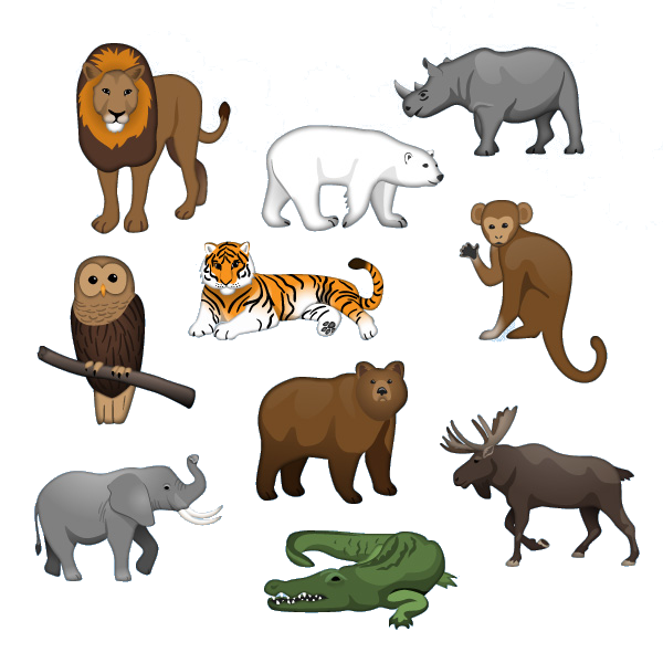 Animal world
China
Democratic People's Republic of Korea
Animal world
China
Democratic People's Republic of Korea
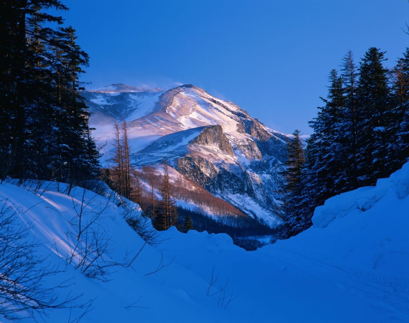
 Geography
Mountains in Asia
Geography
Vulcan
Heilongjiang Sheng-HL
Jilin Sheng-JL
Liaoning Sheng-LN
Geography
Mountains in Asia
Geography
Vulcan
Heilongjiang Sheng-HL
Jilin Sheng-JL
Liaoning Sheng-LN
 Ski vacation
China
Ski vacation
China
长白山(满语:ᡤᠣᠯᠮᡳᠨ
ᡧᠠᠩᡤᡳᠶᠠᠨ
ᠠᠯᡳᠨ,穆麟德:Golmin Šanggiyan Alin,太清:Golmin Xanggiyan Alin),古名不咸山(或为白罗聂·显干之音译)、太白山,在朝鲜半岛称白头山(朝鲜语:백두산/白頭山),是位于中华人民共和国和朝鲜民主主义人民共和国边境的界山。广义的长白山是指一条西南-东北走向绵延上千千米的一系列山脉,横亘于中国吉林、辽宁、黑龙江三省的东部及北朝鲜两江道交界处。狭义上的长白山则单指其主峰长白山,是一座休眠的活火山,在清朝时曾多次喷发。主峰白头峰最高点位于火山臼形成的天池南部的朝鲜民主主义人民共和国境内,天池位于中国和北朝鲜的边界上,在中国部分,分属吉林省白山市抚松县与延边朝鲜族自治州安图县。它实际上是一个相当宽阔的环形火山口(山体相对高度1600米左右,而山体宽度则达十几千米),火山口当中为天池。 由于是中国东北最高峰,长白山在多个中国北方民族的神话传说中都被视为“神山”及朝鲜族的发祥地。长白山是大清龙脉,龙兴之地,是满族祖先世世代代居住的地方,这是一块风水宝地。
Das Gebiet Changbai Shan erstreckt sich über fast 1.000 km entlang der chinesisch – nordkoreanischen Grenze. Ein Großteil dieses Gebirges wurde 1961 zum Naturschutzgebiet erklärt. Die Gipfel erreichen Höhen über 2.500 m, der höchste Berg ist der Baitou Shan, was so viel bedeutet wie Weißkopf-Berg. Sein Gipfel erreicht eine Höhe von 2.744 m. Das Changbai Shan – Gebirge hat mit dem Baitou Shan die höchste Erhebung des ost-asiatischen Kontinents. Das Klima ist hier sehr rau, die Jahresdurchschnittstemperatur liegt gerade mal bei 3 – 7 Grad. Das ehemals vulkanisch aktive Gebiet besitzt einen sehr schönen Kratersee. Durch Ihn verläuft die Grenze zu Nordkorea. Das gesamte Gebiet wurde im Jahre 1980 unter den Schutz der UNESCO gestellt. Zu erreichen ist die Gegend im Norden des Landes am besten mit dem Zug, Endstation der Bahnlinie zum Changbai Chan ist das kleine Dorf Baihe.(Quelle:http://www.reise-ziele-online.de)
Der Paektusan (kor. Weißkopf-Berg), chinesisch Changbai Shan (immerweißer Berg) oder Baitou Shan genannt, ist die höchste Erhebung des Changbai-Gebirges an der Grenze zwischen der Volksrepublik China und Nordkorea. Die Angaben zur Höhe variieren je nach Quelle zwischen 2744 und 2750 Metern.
Der Berg liegt an der Grenze zwischen der nordkoreanischen Provinz Ryanggang-do und der chinesischen Provinz Jilin. Er ist der höchste Berg der Mandschurei, der Koreanischen Halbinsel und Nordkoreas. Auf dem Berg entspringen die Flüsse Songhua, Tumen und Yalu.
白頭山[1](はくとうさん・朝鮮名:ペクトサン)は、朝鮮民主主義人民共和国(北朝鮮)両江道と中華人民共和国(中国)吉林省の国境地帯にある標高2,744mの火山。別名、長白山[2](ちょうはくさん)。
中国吉林省と北朝鮮両江道の国境地帯にあるこの山は、古くは「不咸山」「白山」「太白山」と呼ばれた[要出典]。このうち「白山」「太白山」は中国でも朝鮮でも後世までこの山の別名としても使われた。李氏朝鮮の時代には「太白山」と呼んでいた。現在北朝鮮と大韓民国(韓国)が用いている白頭山という名称の起源は不明である。
満州民族の満州語ではゴルミン・シャンギャン・アリン(満州文字:ᡤᠣᠯᠮᡳᠨ
ᡧᠠᠩᡤᡳᠶᠠᠨ
ᠠᠯᡳᠨ、転写:golmin šanggiyan alin、漢字音写:果勒敏珊延阿林、意は「どこまでも白い山」)と金の時代より使われ始めた。 清朝では長白山(ちょうはくさん。中国語: 簡体字中国語: 长白山; 繁体字: 長白山、チャンパイシャン、Chángbáishān)と漢訳され定着している。
Paektu Mountain (Korean: 백두산, 白頭山), also known as Baekdu Mountain and in China as Changbai Mountain (simplified Chinese: 长白山; traditional Chinese: 長白山), is an active stratovolcano on the Chinese–North Korean border.[3] At 2,744 m (9,003 ft), it is the highest mountain of the Changbai and Baekdudaegan ranges. Koreans assign a mythical quality to the volcano and its caldera lake, considering it to be their country's spiritual home.[4] It is the highest mountain in Korea and Northeast China.[5]
A large crater lake, called Heaven Lake, is in the caldera atop the mountain. The caldera was formed by the VEI 7 "Millennium" or "Tianchi" eruption of 946, which erupted about 100–120 km3 (24–29 cu mi) of tephra. This was one of the largest and most violent eruptions in the last 5,000 years (alongside the Minoan eruption, the Hatepe eruption of Lake Taupo in around AD 180, the 1257 eruption of Mount Samalas near Mount Rinjani and the 1815 eruption of Tambora).
The mountain plays an important mythological and cultural role in the societies and civil religions of both contemporary Korean states. For instance, it is mentioned in both of their national anthems and is depicted on the national emblem of North Korea.
Le mont Paektu ou mont Changbai en Chine est le point culminant de l'ensemble de la Corée, à 2 744 mètres d'altitude. C'était un mont sacré pour les Coréens et les Mandchous. En 946, il a été le théâtre d'une des plus fortes éruptions de notre ère. Sa partie chinoise est protégée par la réserve naturelle du mont Changbai qui a été reconnue réserve de biosphère en 1979, et sa partie nord-coréenne par la réserve naturelle du mont Paektu, réserve de biosphère depuis 1989 (1 320 km2). Situé dans une zone inhospitalière, ses abords sont relativement peu peuplés.
Il Monte Paektu, anche noto come Baitou (in cinese 白頭山T, 白头山S, BáitóushānP) e Baekdu (백두산?, 白頭山?, PaektusanMR), è il picco più alto della penisola coreana (2.744 m), al confine fra la Corea del Nord e la Cina. Il suo nome cinese è Changbai (長白山T, 长白山S, ChángbáishānP), da cui il nome della catena montuosa a cui appartiene, il Changbai Shan.
El monte Paektu (en chosŏn'gŭl, 백두산; en hancha, 白頭山; romanización revisada del coreano, Baektu-san; McCune-Reischauer, Paektu-san), también conocido como montaña Changbai en China, es una montaña volcánica localizada en la frontera entre Corea del Norte y China. Con 2744 m, es la montaña más alta de la montañas Changbai, al norte, y de la cordillera Baekdudaegan, al sur. También es la montaña más alta de la península de Corea y de Manchuria.
Пэктуса́н[2][3], также Байтоушань[2][3] (кор. 백두산) или Чанбайша́нь (кит. 长白山) — потенциально активный вулкан на границе КНДР (провинция Янгандо) и КНР (провинция Цзилинь). Гора имеет высоту 2744 м (2750 м[2]) и является высшей точкой Маньчжуро-Корейских гор, а также всей Маньчжурии и Корейского полуострова[4].
 International cities
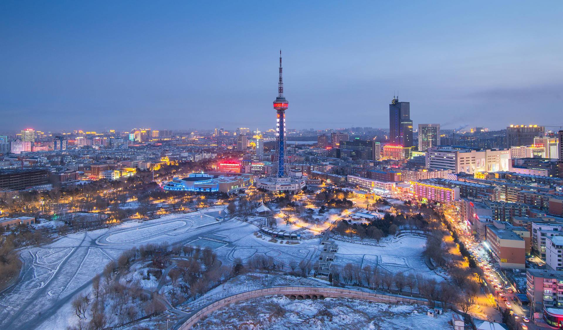
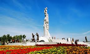
长春市是中华人民共和国吉林省的省会,副省级市,位于中国东北地区的“天然地理中心”[4],中国科学院长春分院、中国科学院东北地理与农业生态研究所、中国科学院长春光学精密机械与物理研究所、东北地区实力最强的综合大学吉林大学位于长春。[5]1932年3月至1945年8月间为满洲国首都新京。
2010年长春常住人口7,677,089人[6],面积20,594平方公里。长春户籍居民包括汉、满、朝鲜、回、蒙古、锡伯等38个民族。长春市区内居住着30多万来自世界各国的外侨,包括日本人、韩国人、欧洲人、北美人、阿拉伯人等[7]。长春是中华人民共和国最大的汽车工业城市和最早的电影工业基地,同时也是中国沿边开放城市。
Changchun (chinesisch 長春市 / 长春市, Pinyin Chángchūn Shì ‚langer Frühling‘) ist die Hauptstadt der Provinz Jilin im Nordosten der Volksrepublik China und eine der 15 Unterprovinzstädte des Landes. Sie hat etwa 3,4 Millionen Einwohner in der Innenstadt (Stand 1. Januar 2010) und ca. 7,7 Mio. im gesamten Stadtgebiet.
長春市(ちょうしゅんし/チャンチュンし、中国語: 长春市、拼音: 、英語: Changchun)は、中華人民共和国吉林省に位置する副省級市で同省の省都。市区人口約438万人・総戸籍人口約749万人(2017年)。吉林省政府が所在し、省内の政治、経済、文化の中心地となっている。1932年から1945年までは満洲国の首都とされ、新京と呼ばれた。 市内には長春第一自動車製造工場と長春映画製作所が所在し、中国における自動車工業と映画製作の拠点となっている。住民は漢族、満族、朝鮮族、回族、モンゴル族、シベ族など38の民族から構成される。
市内には、中国最大規模を誇る吉林大学を含む27の国立大学を抱え、中国科学院長春分院、高い研究開発力を有する中国科学院長春光学精密機械研究所、中国科学院長春応用化学研究所、長春人造衛星観測ステーション、東北地理・農業生態研究所、衛生部長春生物製品所など100余の重点科学研究機構も所在する、中国における重要な研究学園都市であり、科学技術人員の比重は中国でもトップクラスである。
また、北東アジア博覧会、長春映画祭、長春ブックフェア、長春国際モーターショー、長春国際農業食品博覧会など開催し、中国でも有数の会議・展示都市でもある。四季の違いが顕著で「北国春城」の異称を有する。新京時代に満州国の首都であったことから、市内には当時の建築物が多く残っている。
Changchun (simplified Chinese: 长春; traditional Chinese: 長春; pinyin: Chángchūn) is the capital and largest city of Jilin Province.[5] Lying in the center of the Songliao Plain, Changchun is administered as a sub-provincial city, comprising 7 districts, 1 county and 2 county-level cities.[6] According to the 2010 census of China, Changchun had a total population of 7,674,439 under its jurisdiction. The city's urbanized (or metro) area, comprising 5 districts and 4 development areas, had a population of 3,815,270 in 2010 as the Shuangyang and Jiutai districts are not urbanized yet.[3] It is the biggest city in Northeast China, as well as the 9th biggest city in China.
The name of the city means "long spring" in Chinese. Between 1932 and 1945, Changchun was renamed Hsinking (Chinese: 新京; pinyin: Xīnjīng; literally: "new capital") by the Japanese as it became the capital of the Japanese puppet state of Manchukuo, occupying modern Northeast China. After the foundation of the People's Republic of China in 1949, Changchun was established as the provincial capital of Jilin in 1954.
Known locally as China's "City of Automobiles",[7] Changchun is an important industrial base with a particular focus on the automotive sector.[8] Because of its key role in the domestic automobile industry, Changchun was sometimes referred to as the "Detroit of China."[9] Apart from this industrial aspect, Changchun is also one of four "National Garden Cities" awarded by the Ministry of Construction of P.R. China in 2001 due to its high urban greening rate.
Changchun (chinois simplifié : 长春市 ; pinyin : , Tchang-Tchouen en version romanisée d'autrefois) est une ville du Nord-Est de République populaire de Chine, capitale de la province du Jilin, dans le Dongbei (autrefois Mandchourie). Elle a le statut administratif de ville sous-provinciale. Sa population qui est de plus de sept millions d'habitants, parle le « dialecte de Changchun » du groupe du nord-est du mandarin. Pendant l'invasion japonaise de la Mandchourie, l'Empire du Japon, y place la capitale de l'État fantoche du Mandchoukouo, sous le nom de Hsinking et le siège de l'armée du Guandong de 1931 à 1945.
Changchun (长春S, ChángchūnP), situata nel nord-est della Cina, è la capitale della provincia dello Jilin e Città sub-provinciale.
Changchún (chino tradicional: 長春, chino simplificado: 长春, pinyin: Chángchūn, literalmente «Larga Primavera») es una ciudad-subprovincia y capital de la provincia de Jilin en la República Popular China. Entre 1932 y 1945 la ciudad fue renombrada Hsinking y se convirtió en la capital del estado títere japonés de Manchukuo. Después de la fundación de la República Popular de China, en 1954 Changchun se convirtió en la capital de la provincia de Jilin.
Tiene una población total de siete millones y medio de habitantes (2011) y ocupa un área de 20 604 km². En la ciudad conviven más de treinta etnias diferentes, entre las que destacan los han, hui, manchúes y mongoles. La ciudad fue sede de los Juegos Asiáticos de Invierno de 2007. Conocida como la Ciudad del Automóvil de China,2 Changchun es una base industrial importante, en particular del sector del automóvil.3