Deutsch-Chinesische Enzyklopädie, 德汉百科
 Virginia-VA

 AIRBUS
 Airbus Helicopters
AIRBUS
Airbus
AIRBUS
Airbus Defence and Space
Airbus A300
Airbus A310
Airbus A320
Airbus A330
Airbus A340
Airbus A350
Airbus A380
Airbus Group
Airbus
Airbus Helicopters
AIRBUS
Airbus
AIRBUS
Airbus Defence and Space
Airbus A300
Airbus A310
Airbus A320
Airbus A330
Airbus A340
Airbus A350
Airbus A380
Airbus Group
Airbus
 Alabama-AL
 Andalusia
 Bremen
 Castilla-La Mancha
China
Germany
England
Castilla-La Mancha
China
Germany
England
 Florida-FL
France
Florida-FL
France
 Hamburg
 Kansas-KS


 Aerospace
Civil aircraft
Aerospace
Civil aircraft
 Madrid


 Military, defense and equipment
Military aircraft
Military, defense and equipment
Military aircraft
 Lower Saxony
 Occitania
 Pays-de-la-Loire
Spain
Tianjin Shi-TJ
United States
United Kingdom
Virginia-VA
Wales
Pays-de-la-Loire
Spain
Tianjin Shi-TJ
United States
United Kingdom
Virginia-VA
Wales
 Washington, D.C.
 Science and technology

 Eat and Drink
*Cigar
Eat and Drink
*Cigar
 Companies
*Big food companies
Companies
*Centuries-old companies in the world
United States
Virginia-VA
Companies
*Big food companies
Companies
*Centuries-old companies in the world
United States
Virginia-VA
 Geography
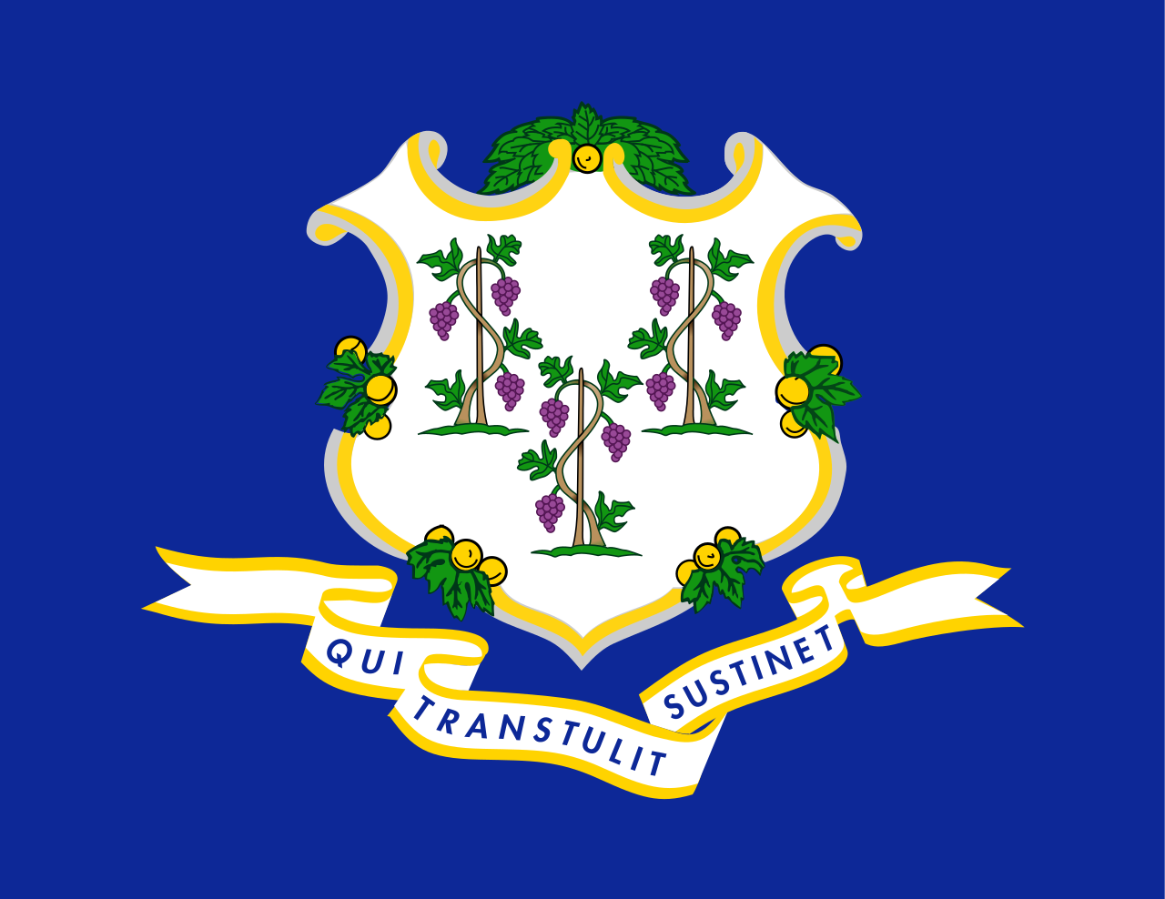 Connecticut-CT
 Georgia-GA
Canada
Georgia-GA
Canada
 Kentucky-KY
 Maine-ME
 Maryland-MD
 Massachusetts-MA
 New Brunswick-NB
 New hampshire-NH
 New York-NY
 Newfoundland and Labrador-NL
 North Carolina-NC
 Nova Scotia-NS
 Ohio-OH
 Pennsylvania-PA
 Quebec-QC
 South Carolina-SC
United States
South Carolina-SC
United States
 Vermont-VT
Virginia-VA
Vermont-VT
Virginia-VA
 West Virginia-WV
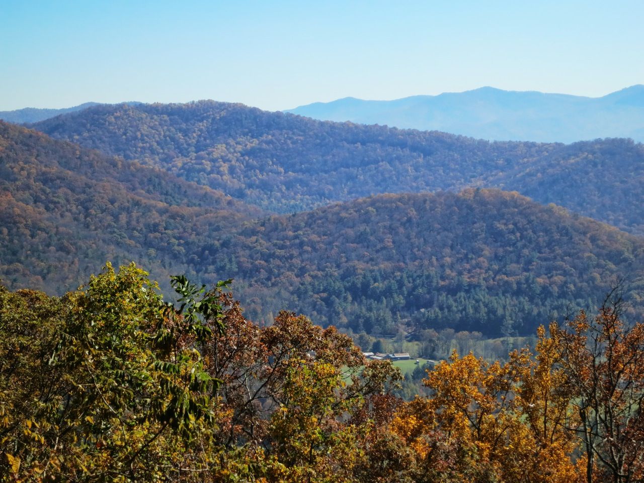
阿巴拉契亚山脉(Appalachian Mountains),又譯阿帕拉契山脉,是北美洲东部的一座山系。南起美国的阿拉巴马州,北至加拿大的纽芬兰和拉布拉多省。最北部余脉则延伸到魁北克的加斯佩地区。最高峰在北卡罗莱纳州的米切尔峰(2037米)。
阿巴拉契亚山脉(英语:Appalachian Mountains),又译阿帕拉契山脉,是北美洲东部的一座山系。南起美国的阿拉巴马州,北至加拿大的纽芬兰和拉布拉多省。最北部余脉则延伸到魁北克的加斯佩地区。最高峰在北卡罗莱纳州的米切尔峰(2037米)。
构成阿巴拉契亚山脉的有纽芬兰省的长岭山、魁北克的圣母山、缅因州的朗费罗山、新罕布夏州的怀特山、佛蒙特州的格林山脉、塔库尼克山;马萨诸塞州的勃克夏山;跨宾夕法尼亚州、马里兰州和西佛吉尼亚州三州的阿勒格尼山脉;跨宾夕法尼亚州、马里兰州、西佛吉尼亚州以及佛吉尼亚州四州的阿巴拉契亚岭谷。还有从宾夕法尼亚州南部到佐治亚州北部的蓝岭山脉。
实际上阿巴拉契高地 严格的边界范围存有争议,阿第伦达克山脉一般被认为是属于加拿大地盾,而非阿巴拉契亚高地。
Die Appalachen (englisch Appalachian Mountains) sind ein bewaldetes Gebirgssystem im Osten Nordamerikas, das sich über eine Länge von 2400 Kilometer von den Long Range Mountains an der Westküste der kanadischen Insel Neufundland bis in den Norden des US-Bundesstaates Alabama erstreckt. Obwohl ihr höchster Gipfel mehr als 2000 Meter hoch ist, haben die Appalachen sowohl hinsichtlich ihrer Höhe als auch ihrer Morphologie einen Mittelgebirgscharakter. Nur wenige Berge erheben sich über mehr als 1200 m Höhe, und viele Bergkuppen bleiben deutlich unter 800 m.
Benannt sind die Appalachen nach dem indigenen Stamm der Apalachee. Für die Appalachenregion als Kultur- und Wirtschaftsraum wird auch die Bezeichnung Appalachia verwendet.[1]
アパラチア山脈(Appalachian Mountains)は、カナダ及びアメリカ合衆国東北部に位置し、北東から南西方向に全長約2,600kmにわたって延びる丘陵・山脈。狭義では、そのうちのウエストバージニア州、バージニア州、ケンタッキー州、テネシー州、ノースカロライナ州等の南側の部分のみを指すこともある。
複雑に褶曲した山脈で、侵食が進んだ丘陵性の古い山脈である。北端はカナダニューファンドランド島で、そこから北アメリカ大陸東部を南西方向に縦断し、南端はアラバマ州の中央に至る。また、その裾野はミシシッピ州北西部にまで及んでいる。個々の山の標高は平均して1,000m前後で、最高峰はノースカロライナ州にあるミッチェル山(標高2,037m)。
山脈の西部では石油・石炭が盛んに採掘されているなど地下資源が豊富。山脈の東側には都市が発達している。国立公園が多く、グレート・スモーキー山脈国立公園やシェナンドー国立公園が有名である。
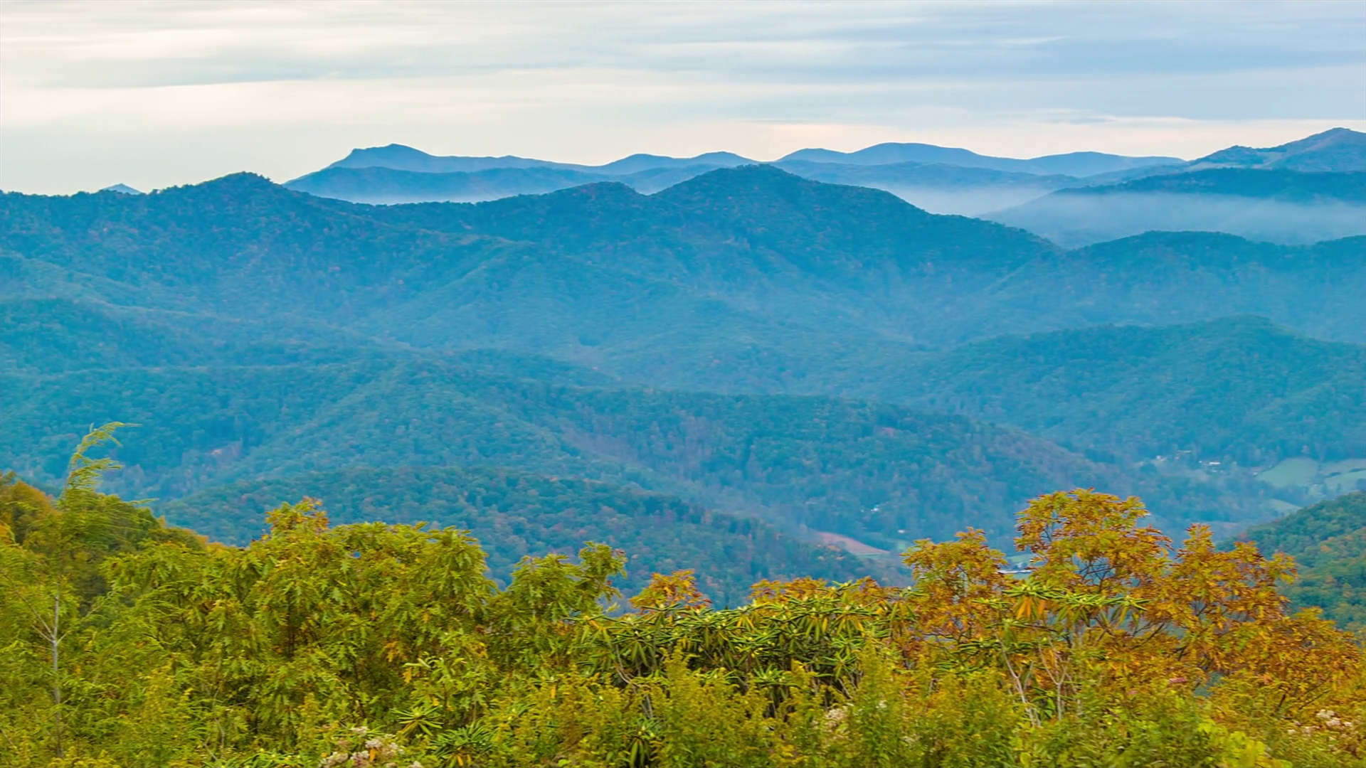
The Appalachian Mountains,[a] often called the Appalachians, are a system of mountains in eastern North America. The Appalachians first formed roughly 480 million years ago during the Ordovician Period. They once reached elevations similar to those of the Alps and the Rocky Mountains before experiencing natural erosion.[4][5] The Appalachian chain is a barrier to east–west travel, as it forms a series of alternating ridgelines and valleys oriented in opposition to most highways and railroads running east–west.
Definitions vary on the precise boundaries of the Appalachians. The United States Geological Survey (USGS) defines the Appalachian Highlands physiographic division as consisting of thirteen provinces: the Atlantic Coast Uplands, Eastern Newfoundland Atlantic, Maritime Acadian Highlands, Maritime Plain, Notre Dame and Mégantic Mountains, Western Newfoundland Mountains, Piedmont, Blue Ridge, Valley and Ridge, Saint Lawrence Valley, Appalachian Plateaus, New England province, and the Adirondack areas.[6][7] A common variant definition does not include the Adirondack Mountains, which geologically belong to the Grenville Orogeny and have a different geological history from the rest of the Appalachians.[8][9][10]
Les Appalaches sont une chaîne de montagnes située dans l'Est de l'Amérique du Nord et s'étendant de Terre-Neuve (Canada), au nord, jusqu'au centre de l'État de l'Alabama, au sud (États-Unis). Elle culmine au mont Mitchell (2 037 mètres) en Caroline du Nord.
Les Appalaches séparent la plaine côtière atlantique (à l'est) du bassin du fleuve Mississippi et des Grands Lacs (à l'ouest). Elles s'étirent sur près de 2 000 km de longueur.
L'exploitation du charbon, qui fournit la moitié de l'électricité américaine, y a fortement périclité, et l'industrie métallurgique est en grande difficulté.
Les Appalaches ont donné leur nom à un type de relief, le relief appalachien, qui désigne les vestiges d'une ancienne montagne fortement arasée. De longs couloirs s'étendent parallèlement à des échines rectilignes. Les cluses appalachiennes forment des passages étroits à travers les chaînons de la montagne.
Le Sentier des Appalaches (AT) parcourt les sommets de la chaîne depuis le Maine jusqu'à la Géorgie et le Sentier international des Appalaches (SIA - IAT) passe par les sommets du nord du Maine jusqu'au cap Gaspé, en Gaspésie. Leur point d'intersection est le sommet du mont Katahdin.
Gli Appalachi (AFI: /appaˈlaki/) o Appalaci (/appaˈlaʧi/[1]; in inglese Appalachian Mountains, in francese Appalaches) sono una catena montuosa situata nella parte orientale dell'America del Nord.
Si sviluppa, quasi parallelamente alla costa orientale atlantica, dal golfo del fiume San Lorenzo fino all'Alabama, per almeno 2500 km con picchi non molto elevati (i più alti sono con 2037 m il monte Mitchell e con 1917 m il monte Washington). Gli Appalachi riguardano anche l'isola di Terranova (Canada) e l'isola francese di Miquelon parte della collettività territoriale di Saint-Pierre e Miquelon[2][3]. La porzione sud degli Appalachi viene chiamata monti Unakas.
Per via dell'età geologica, gli Appalachi sono la catena montuosa più vecchia delle Americhe. Gli Appalachi statunitensi sono una delle zone economicamente più depresse degli Stati Uniti.
Apalaches o montes Apalaches (en inglés: Appalachian Mountains o Appalachians; en francés: Appalaches1) es una importante cordillera ubicada en el este de Norteamérica. Se extiende desde la Isla de Terranova en Canadá, pasado por la colectividad de ultramar francés de San Pedro y Miquelón, hasta Alabama en los Estados Unidos, aunque su parte más septentrional termina en la península de Gaspé, en Quebec. Constituye el elemento morfológico más sobresaliente de la parte oriental de América del Norte.
Se originó en antiguas montañas formadas en el periodo Paleozoico con relieves suavizados por la prolongada acción de los agentes exógenos. El sistema está dividido en una serie de cordilleras, en las que la medida de altura de los picos es de unos 1000 m s. n. m. (metros sobre el nivel del mar). La cima más elevada es el monte Mitchell, en Carolina del Norte, mide 2037 m s. n. m. y es el punto más alto de los Estados Unidos al este del río Misisipi y de todo el este de Norteamérica.
Аппала́чи[2] (англ. Appalachian Mountains) — горная система на востоке Северной Америки, в США и Канаде. Длина — 2600 км.
Северные Аппалачи (к северу от рек Мохок и Гудзон) — холмистое плоскогорье с отдельными массивами высотой до 1916 м (гора Вашингтон), имеют следы древнего оледенения. Южные Аппалачи в осевой зоне состоят из параллельных хребтов и массивов, разделённых широкими долинами; к осевой зоне прилегают с востока плато Пидмонт, с запада — Аппалачское плато. Высота — до 2037 м (гора Митчелл). В горах имеются месторождения каменного угля, нефти и газа, железных руд, титана; широколиственные, хвойные и смешанные леса.
Горы образовались в пермский период в результате столкновения двух материков (возникновение Пангеи).
 Architecture

 蓝岭山脉(英语:Blue Ridge Mountains)是美国东南部的山脉,为阿帕拉契山脉的东段。从宾夕法尼亚州南部起,经马里兰州、维吉尼亚州和北卡罗莱纳州到乔治亚州[1],东北-西南走向延伸约1050公里。沿线包含有布拉许山(Brushy Mountains)和大烟山(Great Smoky Mountains)等较具代表性的山脉,而最高峰米切尔峰海拔2037米。大烟山和谢南多厄国家公园(Shenandoah National Park)则以森林景色闻名[2]。
Die Blue Ridge Mountains sind ein Gebirgszug im Osten der USA. Sie sind ein Teil der Appalachen. Der zu ihnen gehörige Mount Mitchell ist mit einer Höhe von 2037 m (6684 Fuß) der höchste Berg der Gebirgskette und zugleich die höchste Erhebung Nordamerikas östlich des Mississippi.
Auf den Blue Ridge Mountains verläuft der Blue Ridge Parkway. Der Parkway führt in weiten Teilen entlang der Bergkämme und wurde während der Great Depression ab 1935 im Rahmen des New Deals von Bundes- und Staatsbehörden unter Mitarbeit der Works Progress Administration und des Civilian Conservation Corps erbaut.
In John Denvers Lied Take Me Home, Country Roads (1971) werden die Blue Ridge Mountains erwähnt (obgleich sich das Lied vor allem auf West Virginia bezieht, das von diesem Gebirgszug kaum berührt wird). Zudem spielt in dieser Gegend die Fernsehserie Die Waltons.
ブルーリッジ山脈(ブルーリッジさんみゃく、Blue Ridge Mountains)は、アメリカ合衆国東部をジョージア州からペンシルベニア州にかけて走る山脈。アパラチア山脈の一部で、その南東側の端部にあたる。ブルーリッジ山脈という名は、遠方から見た時に青くかすみがかかって見えることから名づけられた。
アメリカ合衆国東部のジョージア州から、北東方向にノースカロライナ州、テネシー州、バージニア州、メリーランド州を経て、ペンシルベニア州に至る山脈である。最高地点は、アパラチア山脈の最高地点でもあるミッチェル山(Mount Mitchell、標高2,037m、ノースカロライナ州)。
ブルーリッジ山脈には、グレート・スモーキー山脈国立公園のあるグレート・スモーキー山脈等が含まれる。ブルーリッジ山脈の西側は、リッジ・アンド・バレー地方(Ridge-and-valley Appalachians)や、シェナンドー渓谷のあるグレート・バレー(Great Appalachian Valley)を介してアパラチアン山脈の本体に連なる。
アメリカ合衆国のオールアメリカンロードのひとつであるブルーリッジ・パークウェイが、ブルーリッジ山脈をぬってシェナンドー国立公園とグレート・スモーキー山脈国立公園を結んでいる。
ジョン・デンバーが歌った『故郷へかえりたい』Take Me Home, Country Roadsの冒頭では、ウエストバージニア州の風景のひとつとしてブルーリッジ山脈が挙げられているが、実際にはブルーリッジ山脈はウエストバージニア州にはかかっていない。
The Blue Ridge Mountains are a physiographic province of the larger Appalachian Mountains range. The mountain range is located in the eastern United States, and extends 550 miles southwest from southern Pennsylvania through Maryland, West Virginia, Virginia, North Carolina, South Carolina, Tennessee, and Georgia.[1] This province consists of northern and southern physiographic regions, which divide near the Roanoke River gap.[2] To the west of the Blue Ridge, between it and the bulk of the Appalachians, lies the Great Appalachian Valley, bordered on the west by the Ridge and Valley province of the Appalachian range.
The Blue Ridge Mountains are noted for having a bluish color when seen from a distance. Trees put the "blue" in Blue Ridge, from the isoprene released into the atmosphere,[3] thereby contributing to the characteristic haze on the mountains and their distinctive color.[4]
Within the Blue Ridge province are two major national parks – the Shenandoah National Park in the northern section, and the Great Smoky Mountains National Park in the southern section – and eight national forests including George Washington and Jefferson National Forests, Cherokee National Forest, Pisgah National Forest, Nantahala National Forest and Chattahoochee National Forest. The Blue Ridge also contains the Blue Ridge Parkway, a 469-mile (755 km) long scenic highway that connects the two parks and is located along the ridge crest-lines with the Appalachian Trail.[5]
Les montagnes Blue Ridge ou montagnes Bleues (en anglais Blue Ridge Moutains, littéralement « montagnes du massif bleu »1) sont une chaîne de montagne de l'est des États-Unis. Elles forment la partie orientale des Appalaches, et s'étendent sur 880 km de la Pennsylvanie au nord à la Géorgie au sud, en passant par le Maryland, la Virginie-Occidentale, la Virginie, la Caroline du Nord, la Caroline du Sud et le Tennessee.
À l'ouest des Blue Ridge se trouve la Grande vallée des Appalaches (en), qui les sépare du reste du massif.
Les montagnes Blue Ridge sont appelées ainsi pour leur couleur bleuâtre quand elles sont observées de loin. Les arbres apportent le bleu grâce à l'isoprène dégagé dans l'atmosphère2, donnant sa couleur distinctive à la brume caractéristique sur les montagnes.
La catena montuosa si estende da Harper's Ferry, Virginia Occidentale, e si spinge verso sud-ovest, attraversa la Virginia e la Carolina del Nord fino all'interno della Georgia; talvolta si considera come facente parte anche la regione più settentrionale, con Maryland, Pennsylvania e New York.
La vetta più elevata è Monte Mitchell con 2.037 metri, situato nella Carolina del Nord. La catena montuosa ha un'altezza media compresa tra i 600 e i 1200 metri sul livello del mare.
L'esplorazione dei monti avvenne dal 1716 su impulso del governatore della Virgina Alexander Spotswood.
La cordillera Azul (en inglés, Blue Ridge Mountains) es una sección de los Apalaches, que es una importante cordillera ubicada en el este de Norteamérica. La cordillera Azul se extiende íntegramente en Estados Unidos, formando parte de los siguientes siete estados: Pensilvania, Maryland, Virginia, Carolina del Norte, Carolina del Sur, Tennessee y Georgia, como se puede observar en el mapa a la derecha.
El pico más alto de la cordillera (y de toda la cadena de los Apalaches) es el monte Mitchell en Carolina del Norte de 2037 m. Hay 39 picos en Carolina del Norte y Tennessee superiores a los 1800 m; si se compara con la porción norte de los montes Apalaches, solo el monte Washington de Nuevo Hampshire supera los 1800 m.
Голубо́й хребе́т (Блу-Ридж; англ. Blue Ridge Mountains) — цепь горных хребтов и массивов на востоке США, вдоль юго-восточной окраины Аппалачей. Поднимается над плато Пидмонт.
Протяжённость гор составляет более 1000 км. Наиболее высокая вершина — гора Митчелл (2037 м). Горы сложены метаморфическими породами. На склонах произрастают широколиственные и хвойные леса, в межгорных впадинах и котловинах — луга.
 Financial
 Economy and trade


 Universities in the USA


 IT-Times