Das Huashan-Gebirge (auch Taihua-Gebirge genannt), eines der fünf heiligen Gebirge in China, liegt im Süden des Kreises Huayin, 120 km östlich von Xi'an und hat eine Höhe von 2.100 m über dem Meeresspiegel. Vom Hauptgipfel des Gebirges aus kann man im Norden den Huanghe (Gelber Fluß ) und dessen Nebenfluß Weihe sehen, im Süden geht das Gebirge in das Qinling-Gebirge über. In China gibt es den Spruch: "Der Huashan hat seit alten Zeiten nur einen Weg zum Gipfel". Der einzige 15 km lange unwegsame Pfad führt den südlichen Berghang entlang zum Hauptgipfel des Gebirges.(Quelle: www.chinarundreisen.com)
Der Huà Shān (chinesisch 華山 / 华山) ist einer der fünf heiligen Berge in der Provinz Shaanxi in der Nähe der Kreisstadt Huayin der Volksrepublik China.
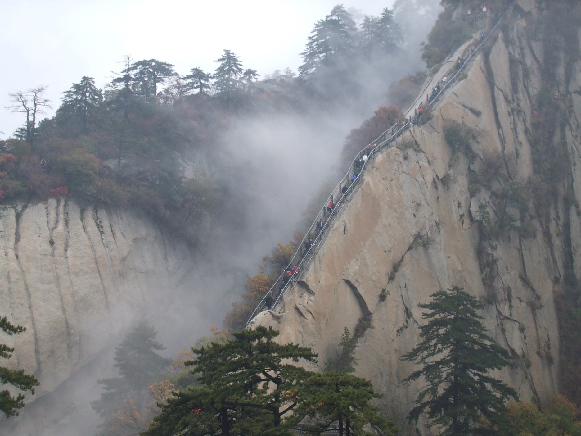
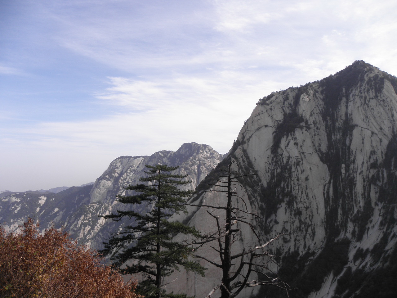
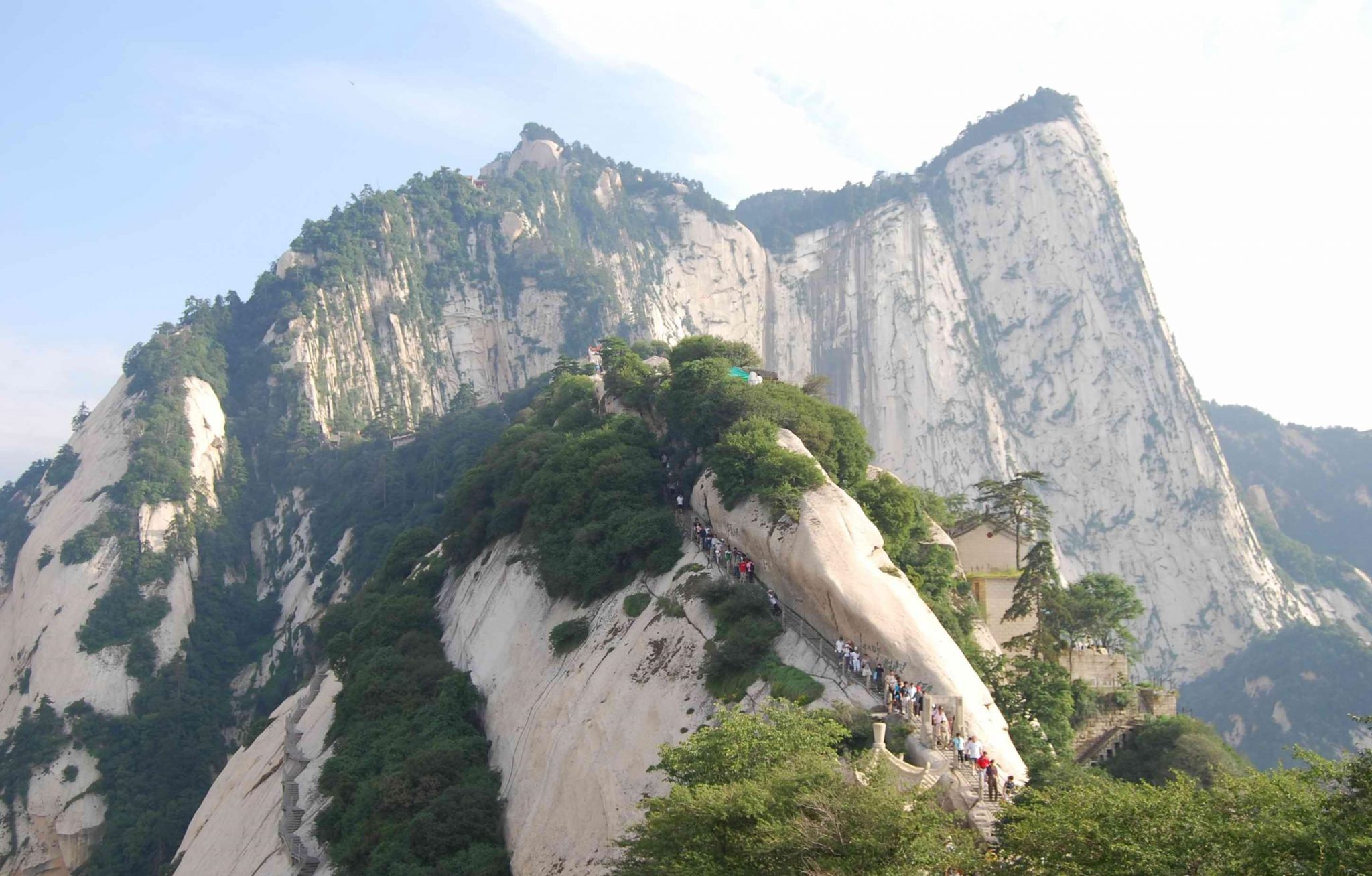
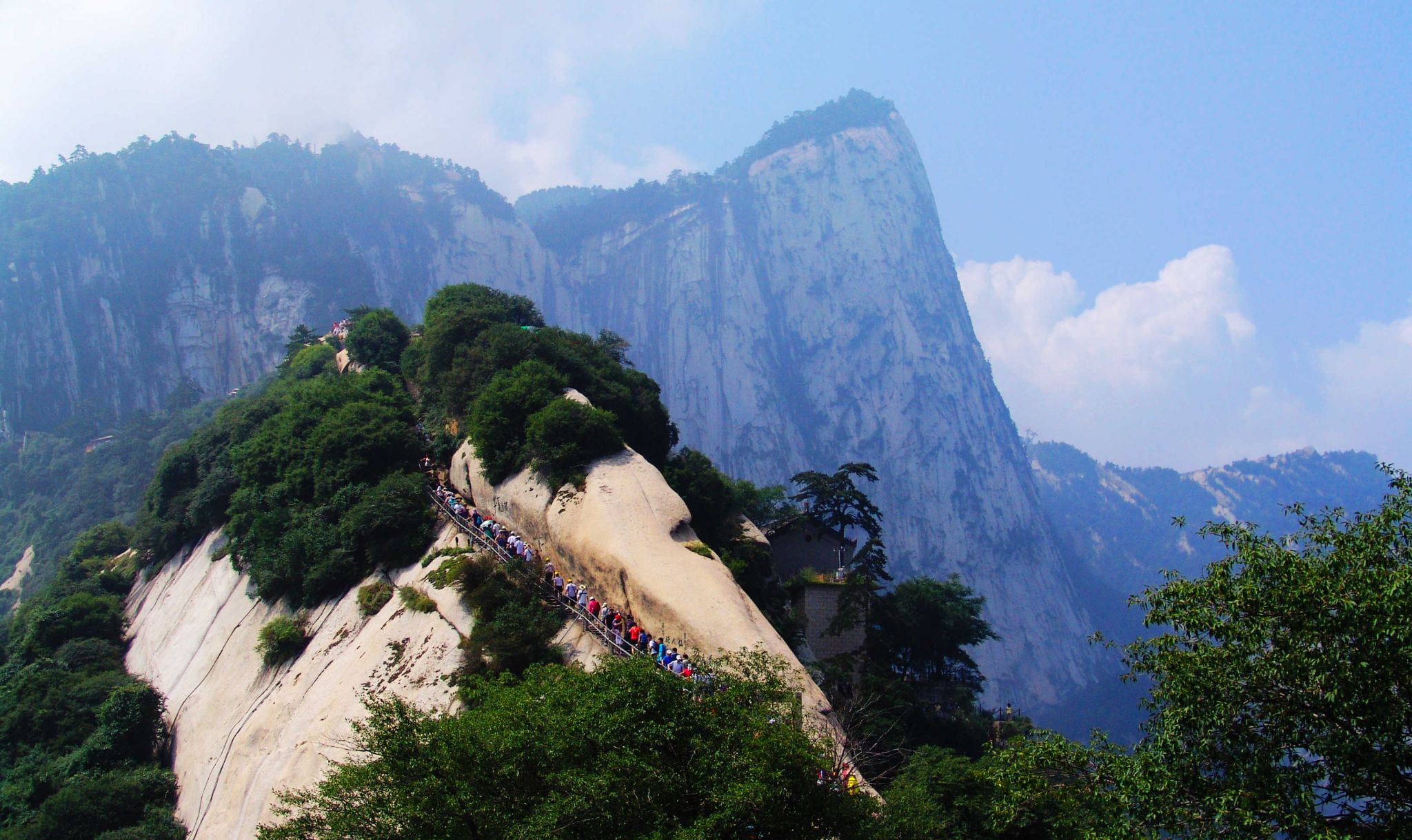
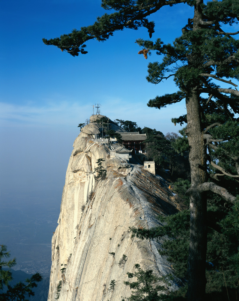
Das Gebirgsmassiv ist wegen seiner steilen, malerischen Felswände und seiner gefährlichen Steige auf die Gipfel berühmt. Mehrere Gipfel bis 2155 m sind durch Bergpfade miteinander verbunden. Entlang der Pfade befinden sich Klöster, Pagoden, Tempel, Brücken und Tore.
Im alten chinesischen Weltbild, das das Reich der Mitte als Quadrat betrachtete, verkörpert das Hua-Shan-Gebirgsmassiv den westlichen Eckberg.Der Dongdao-Tempel, einer der 21 wichtigsten daoistischen Tempel.
'华山(亦称太华山,“华”字古亦作“崋”),五岳之一,又称西岳' 。位于中国陕西省华阴市城南,西距西安市区120公里,秦、晋、豫黄河三角洲交汇处,南接秦岭,北瞰黄河,扼西北进出中原之门户。华山山体倚天拔地,四面如削,更有千尺幢、百尺峡、苍龙岭、鹞子翻身、长空栈道等十分险峻之地,被誉为“奇险天下第一山”。华山共有五峰,即东峰朝阳,西峰莲花,中峰玉女,南峰落雁,北峰云台。南峰落雁,为太华极顶,海拔2154.9米;西峰最险,海拔2082米;北峰最低,海拔1614.7米。另外,南峰落雁、东峰朝阳,西峰莲花,合称“天外三峰”。
华山同时也是道教名山,是三十六洞天中的第四洞天。华山自古以来就是负有盛名的胜地,传说萧史在此吹箫引来秦穆公女弄玉倾慕,隋唐孙思邈常入华山采药,北宋即有睡仙陈抟隐居于此。 1982年,华山以“陕西华山风景名胜区”的名义,被中华人民共和国国务院批准列入第一批国家重点风景名胜区名单,其游览面积约150平方公里。
华山又名西岳,与东岳泰山并称。据说是因周平王迁都洛阳,华山位于东周京城洛邑之西,故称“西岳”,以后秦王朝建都咸阳,西汉王朝建都长安,都在华山之西,所以华山不再称西岳。后来汉光武帝刘秀在洛阳建立东汉政权,华山又恢复了“西岳”之称,并一直沿用至今。 “西”是指地处中原的西边,而“岳”是中国五大名山的总称。华山是五岳中最年轻的山脉,据地质部门1984年观测,目前它还在继续增高。
北魏地理学家郦道元在《水经注》中,对华山有“其高五千仞,削成而四方,远而望之,又若花状”的描绘。古代“花”与“华”相通,可见华山之名实际上得自于形状。关于华山得名,还有另一种说法:因华山顶上生长着白莲花,故而得名。韩愈的《古意》诗中所写的“太华峰顶玉井莲,花开十丈藕如船”,就是根据此传说。民间对其险峻有诸多描绘,最著名的谚语为“自古华山一条路”。
華山(かざん、古は崋山とも、中国語: 華山/华山、拼音: Huà Shān ホワシャン)は、中国陝西省華陰市にある山。中国五名山の一つとして、西岳とも呼ばれる。
中国において、花崗岩が露出した険しい山肌が続く景勝地として知られ、国家級風景名勝区(第1期)に指定されている[1]。道教や仏教などの修行地として利用され、歴史的な建造物が点在する。
華山は最高峰である南峰(2,154m)の他に、北峰(1,614m)、中峰(2,037m)、東峰(2,096m)、西峰(2,082m)の5つから構成されている。
山頂周辺へのアクセス手段には、北峰側の三特索道と、西峰側の太華索道がある。このうち太華索道は、2013年に開業した全長4,211mの世界最長クラスのロープウェーである[2]。
花崗岩の岩場を削って、無数の石段が作られており、一部には断崖絶壁の上に作られた20cmほどしかない足場や桟道を通って行かねばならない場所があり、宗教聖地として、格段の険しい山として知られる。
Mount Hua (simplified Chinese: 华山; traditional Chinese: 華山; pinyin: Huà Shān[1]) is a mountain located near the city of Huayin in Shaanxi province, about 120 kilometres (75 mi) east of Xi'an. It is the western mountain of the Five Great Mountains of China, and has a long history of religious significance. Originally classified as having three peaks, in modern times the mountain is classified as five main peaks, of which the highest is the South Peak at 2,154.9 metres (7,070 ft).
Mount Hua is situated in Huayin City, which is 120 kilometres (about 75 miles) from Xi'an. It is located near the southeast corner of the Ordos Loop section of the Yellow River basin, south of the Wei River valley, at the eastern end of the Qin Mountains, in southern Shaanxi province. It is part of the Qinling or Qin Mountains, which divide not only northern and southern Shaanxi, but also China.
Traditionally, only the giant plateau with its summits to the south of the peak Wuyun Feng (五雲峰, Five Cloud Summit) was called Taihua Shan (太華山, Great Flower Mountain). It could only be accessed through the ridge known as Canglong Ling (蒼龍嶺, Dark Dragon Ridge) until a second trail was built in the 1980s to go around Canglong Ling. Three peaks were identified with respective summits: the East, South, and West peaks.
The East peak consists of four summits. The highest summit is Zhaoyang Feng (朝陽峰, Facing Yang Summit, i.e. the summit facing the sun). Its elevation is reported to be 2,096 m (6,877 ft) and its name is often used as the name for the whole East Peak. To the east of Zhaoyang Feng is Shilou Feng (石樓峰, Stone Tower Summit), to the south is Botai Feng (博臺峰, Broad Terrace Summit) and to the west is Yunű Feng (玉女峰}, Jade Maiden Summit). Today, Yunű Feng considered its own peak, most central on the mountain.
The South peak consists of three summits. The highest summit is Luoyan Feng (落雁峰, Landing Goose Summit), with an elevation of 2,154 m (7,067 ft). To the east is Songgui Feng (松檜峰, Pines and Junipers Summit), and to the west is Xiaozi Feng (孝子峰, Filial Son Summit).
The West peak has only one summit and it is known as Lianhua Feng (蓮花峰) or Furong Feng (芙蓉峰), both meaning Lotus Flower Summit. The elevation is 2,082 m (6,831 ft).
With the development of new trail to Hua Shan in the 3rd through 5th century along the Hua Shan Gorge, the peak immediately to the north of Canglong Ling, Yuntai Feng (雲臺峰, Cloud Terrace Peak), was identified as the North peak. It is the lowest of the five peaks with an elevation of 1,614.9 m (5,298 ft).
Le mont Hua (sinogrammes simplifiés : 华山 ; sinogrammes traditionnels : 華山 ; pinyin : huà shān) est situé dans la province du Shaanxi, à une centaine de km à l'est de la capitale Xi'an. C'est l'une des cinq montagnes sacrées de Chine aussi connue sous le nom de montagne de l'Ouest (sinogrammes simplifiés : 西岳; sinogrammes traditionnels : 西嶽; pinyin : xī yuè). Le mont Hua est également appelé 太华山 (pinyin : tài huà shān) ou 华通花 (pinyin : huà tōng huā). Le plus haut sommet du mont Hua est le pic Luoyan (sinogrammes : 落雁峰 ; pinyin : luò yàn fēng) également connu sous le nom de pic du Sud (sinogrammes : 南峰 ; pinyin : nán fēng) qui culmine à 2 154,9 m.
Il monte Hua o Hua shan è una montagna situata vicino alla città di Huayin, nella provincia di Shaanxi a circa 120 chilometri ad est di Xi'an. Si tratta di una delle cinque grandi Montagne sacre cinesi, ed è da secoli meta di pellegrinaggi. In passato si riteneva avesse tre picchi, ma oggi se ne riconoscono cinque principali, dei quali il più elevato è il picco sud, con 2.154,9 metri di altitudine. La montagna è situata vicino l'angolo a sudest dell'altopiano del Loess nel bacino del fiume giallo, a sud della valle del fiume Wei, nella parte orientale dei monti di Qin, nella provincia Shaanxi meridionale.
El monte Hua (chino tradicional: 華山, chino simplificado: 华山, literalmente «Monte del Esplendor»), conocido también como Huá Shan, se halla en la provincia de Shănxī, 120 km al este de la ciudad de Xi'ian y cerca de Huayin, en China. Originalmente, estaba formado por tres picos, pero actualmente, este lugar sagrado tiene cinco picos, de los cuales el más alto es el pico Sur, de 2160 m. Es una de las cinco montañas sagradas del taoísmo.
El 29 de noviembre de 2001 el «Área Escénica Hua Shan» fue inscrita en la Lista Indicativa de China del Patrimonio de la Humanidad, en la categoría de bien mixto (nº. ref 1626).1 Son 204 km² (148 km² área escénica protegida y 56 km² de zona periférica de protección) en la que hay 323 sitios escénicos naturales principales, 1500 reliquias culturales (conjuntos y piezas), más de 300 piezas de tablas de piedra y unas 570 inscripciones rupestres.1
Хуашань (кит. трад. 華山, упр. 华山, пиньинь: Huàshān) — одна из пяти Священных Гор даосизма в Китае, находится в хребте Циньлин на территории провинции Шэньси, недалеко от уездного города Хуаинь (станция на железной дороге Сиань — Лоян).
Гора знаменита изысканными живописными скалами и сложным опасным подъёмом на вершину. Горная тропинка соединяет много вершин до самой высокой 2130 м, это уникальный горный маршрут. По дороге находятся многочисленные даосские монастыри, пагоды, храмы, ворота и мостики.
На старой китайской карте мира, где страна представлялась в форме квадрата, гора Хуашань занимала место в западном углу.


 Vacation and Travel