


This image, video or audio may be copyrighted. It is used for educational purposes only.
 China
Democratic People's Republic of Korea
Jiangsu Sheng-JS
Liaoning Sheng-LN
Republic of Korea
Shandong Sheng-SD
China
Democratic People's Republic of Korea
Jiangsu Sheng-JS
Liaoning Sheng-LN
Republic of Korea
Shandong Sheng-SD
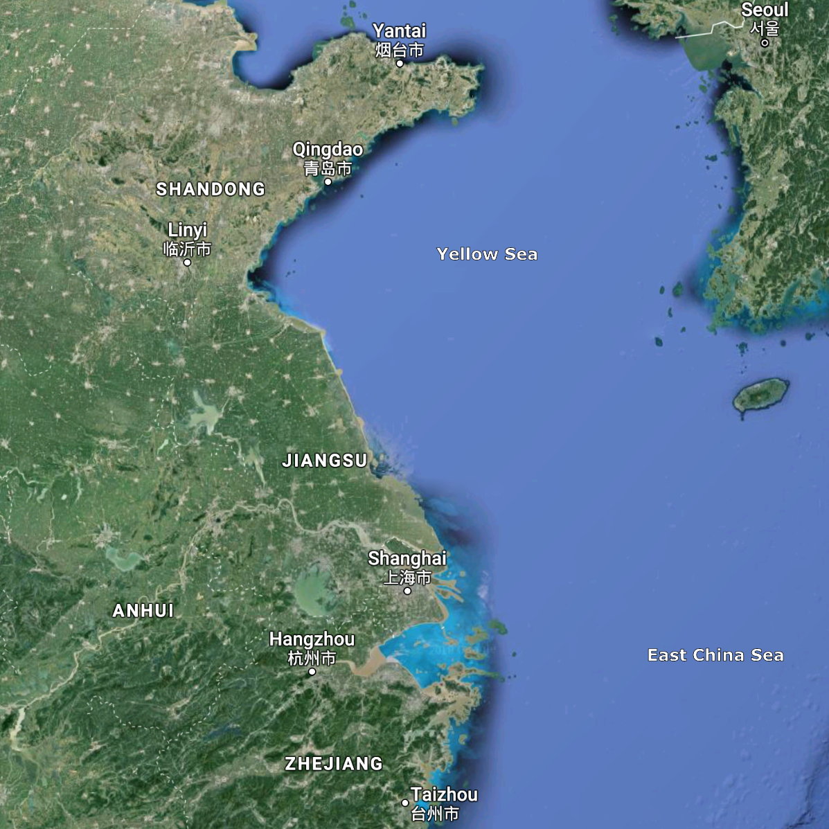
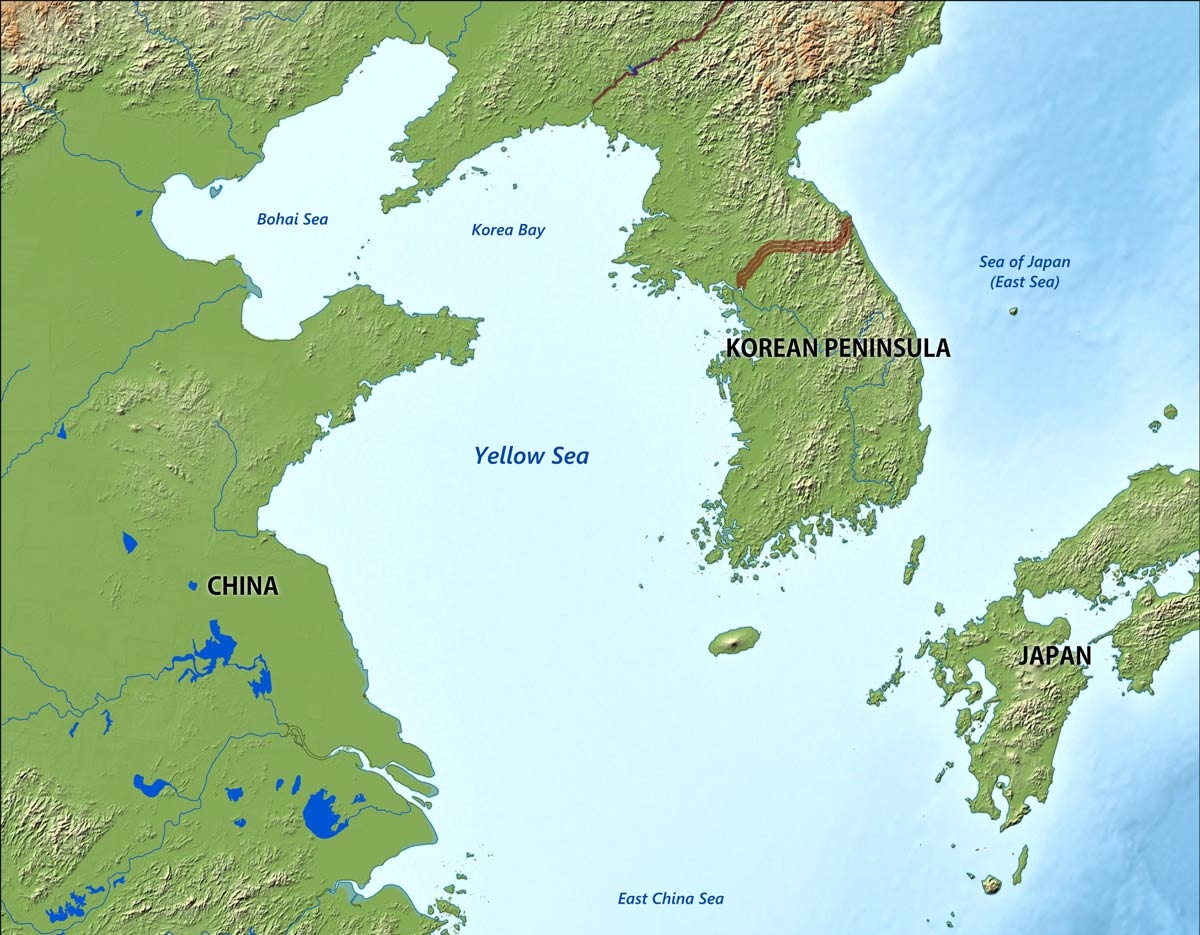
Das Gelbe Meer ist ein Teil des Chinesischen Meeres und ein von der Volksrepublik China und der Koreanischen Halbinsel umgebenes Randmeer des Pazifischen Ozeans. Der Golf von Bohai und die Koreabucht im Norden sind Teile des Gelben Meeres. Im Süden schließt sich das Ostchinesische Meer an.
Das Gelbe Meer misst 960 Kilometer von Nord nach Süd und ist 700 Kilometer breit. Die Flächenausdehnung beträgt 380.000 km². Es ist durchschnittlich 44 Meter und maximal 152 Meter tief. Damit ergibt sich ein Wasservolumen von 16.720 km³. Das Gelbe Meer ist ein flaches Meer, vergleichbar mit der Nordsee am anderen Ende des eurasischen Kontinents. Seine Wattflächen sind ein bedeutendes Rastgebiet für Watvögel.
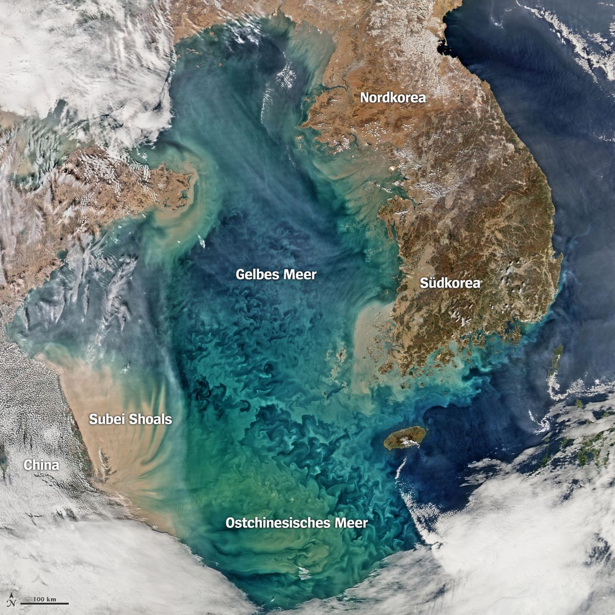
Seine charakteristische Farbe, die zur Namensgebung führte, erhält es von dem nährstoffhaltigen gelben Schwemmsand, dem Löss, den der Gelbe Fluss und andere Flüsse an ihrer Mündung in das Gelbe Meer hineintragen und dort ablagern.
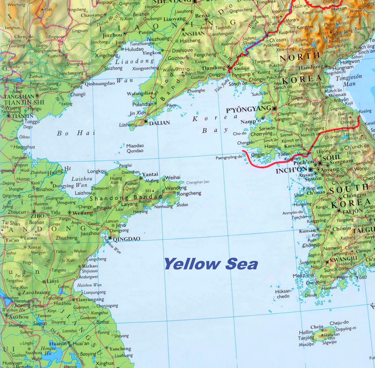
黄海,韩国和朝鲜基于地理位置有时会称为西海,是太平洋西部的一个边缘海,位于中国大陆与朝鲜半岛之间。黄海平均水深44米,海底平缓,为东亚大陆架的一部分。 黄海的名称来源于它的大片水域水色呈黄色,由于历史上黄河有七八百多年的时间注入黄海(入海口在中国江苏省滨海,即今天的废黄河口;1855年咸丰黄河大改道,重新注入渤海),使得河水中携带的大量泥沙将黄海近岸的海水染成了黄色。在韩语环境中,韩国因其位于朝鲜半岛西侧也称为“西海”(朝鲜语:서해/西海 Seohae),但使用黄海(朝鲜语:황해/黃海 Hwanghae)的情况也较多;朝鲜则在大部分情况下称呼“朝鲜西海”(朝鲜语:조선서해/朝鮮西海 Josŏnsŏhae);但国际上通常沿用中国的称呼“黄海”(Yellow Sea)。 黄海从中国的胶东半岛成山角到朝鲜的长山串之间海面最窄,习惯上以此连线将黄海分为北黄海和南黄海两部分,北黄海面积7.1万平方公里,南黄海面积31万平方公里。黄海的西北部它通过渤海海峡与渤海相连,东部由济州海峡与朝鲜海峡相通,南以长江口北岸启东角到济州岛西南角连线与东海分界。注入黄海的主要河流有鸭绿江、大同江、汉江、淮河等,主要沿海城市有中国连云港、盐城、日照、青岛、烟台、威海、大连、丹东、朝鲜的新义州,南浦、韩国的仁川等。属黄海的海湾有西朝鲜湾、江华湾、群山湾、海州湾、胶州湾、荣成湾等。黄海内的岛屿主要集中在辽东半岛东侧、胶东半岛东侧和朝鲜半岛西侧边缘。其中比较大的有外长山列岛、长山群岛、薪岛、椵岛、白翎岛、德积群岛、格列飞群岛、古群山群岛、大黑山群岛、罗州群岛、楸子群岛、济州岛等。濒临黄海的主要行政区有中国的辽宁、山东和江苏三省,朝鲜的新义州特别行政区、平安北道、平安南道、黄海南道、开城工业地区,韩国的京畿道、仁川广域市、忠清南道、全罗北道、全罗南道、济州特别自治道。
黄海(こうかい、英語:Yellow Sea)は、中国大陸と朝鮮半島の間にある海[1][2]。 黄河から運ばれる黄土により黄濁している部分があることから黄海と呼ばれている。フランスの地図製作者ダンヴィルが1737年に作成した『中国新地図帳』に黄海 (Hoang Hai ou Mer Jaune) と表記したことで国際的にも認知されるようになった。
The Yellow Sea is a marginal sea of the Western Pacific Ocean located between mainland China and the Korean Peninsula, and can be considered the northwestern part of the East China Sea. It is one of four seas named after common colour terms (the others being the Black Sea, the Red Sea and the White Sea), and its name is descriptive of the phenomenon whereby fine sand grains from the Gobi Desert sand storms, that descend annually from the northwest, turn the surface of its waters a golden yellow.
The innermost bay of northwestern Yellow Sea is called the Bohai Sea (previously Pechihli Bay or Chihli Bay), into which flow some of the most important rivers of northern China, such as the Yellow River (through Shandong province and its capital Jinan), the Hai River (through Beijing and Tianjin) and the Liao River (through Liaoning province). Sand and silt carried down by these rivers contribute further to the sea's colour. The northern extension of the Yellow Sea is called the Korea Bay, into which flow the Yalu River, the Chongchon River and the Taedong River.
La mer Jaune est un bras de mer de l'océan Pacifique qui sépare la Chine de la péninsule coréenne. Elle s'ouvre au sud sur la mer de Chine orientale qui la borde. Son nom provient du sable et des sédiments apportés par le vent soufflant depuis le désert de Gobi et par les fleuves, en particulier le fleuve Jaune et le Hai He qui lui donnent une couleur jaune1. En Corée, elle est aussi appelée la mer de l'Ouest. Sa partie septentrionale est appelée golfe de Corée et communique avec le golfe de Bohai qui se trouve de l'autre côté des péninsules du Liaodong et du Shandong. Cette dernière partie est aussi incluse dans la mer Jaune. Celle-ci mesure 960 km du nord au sud et 700 km de l'est à l'ouest pour une superficie de 380 000 km2, le golfe de Bohai non compris2. Reposant sur le plateau continental, c'est une mer peu profonde : la profondeur moyenne est de 44 m pour un maximum de 152 m. Cette mer est récente puisqu'elle a été formée à la fin du dernier âge glaciaire, il y a près de 10 000 ans lorsque le niveau des eaux monta de 120 mètres. Le fond de la mer descend lentement du côté de la Chine et remonte plus rapidement du côté de la Corée. La côte de Corée du Sud est très découpée, comprenant de nombreuses îles telles que celles de Ganghwa, Jeju et Yeonpyeong. Les plus grands fleuves proviennent de Chine et débouchent dans le Bohai (le fleuve Jaune, le Hai He et le Liao). Au niveau de la péninsule coréenne, le Yalou et le Taedong se jettent dans le golfe de Corée tandis que le fleuve Han arrive dans la mer Jaune proprement dite.
Il mar Giallo (in cinese 黄海S, Huáng HǎiP e in coreano: 황해, Hwanghae) è una porzione dell'Oceano Pacifico posta a settentrione del mar Cinese Orientale, tra la costa cinese e la penisola coreana. Copre una superficie di circa 417000 km² e sulle sue acque si affacciano la Cina, la Corea del Nord e la Corea del Sud.
Il mar Giallo è chiamato mare Occidentale nelle due Coree. Il suo nome deriva dai sedimenti di colore giallo che colorano le sue acque, apportati da vari fiumi, in particolare dal fiume Giallo (Huáng Hé).
La parte più interna del mar Giallo è costituita dal golfo di Bohai che è compreso tra le penisole di Liaodong a nord e dello Shandong a sud.
È un mare poco profondo con una profondità massima di 105 metri, ma nonostante ciò è molto trafficato con importanti porti sia sulla costa cinese sia su quella coreana. La parte settentrionale del mare gela in inverno.
El mar Amarillo (en chino simplificado, 黄海; pinyin, huáng hǎi, en coreano, 황해 [Hwang Hae]) es la parte norte del mar de la China Oriental que se convierte en parte del océano Pacífico. Es un amplio mar, ocupando un área de cerca de 417 000 km², aunque es poco profundo, con una profundidad máxima de 105 metros.
Está situado entre la China continental y la península de Corea. Su nombre proviene de las partículas de arena que le dan ese color al agua, originalmente del río Amarillo, Huang he. Se conoce también localmente, en Corea del Sur, con el nombre de mar del Oeste.
La inmensa bahía que forma el fondo del mar Amarillo recibe el nombre de mar de Bohai (conocido anteriormente como bahía de Zhili). En ella desemboca el río Amarillo, después de cruzar la provincia de Shandong y su capital, Jinan, así como el río Hai que cruza Pekín y Tianjin.
La bahía de Corea, entre la provincia china de Liaoning y el noroeste de Corea del Norte, forma parte también del mar Amarillo. El mar de Bohai y la península de Corea están separadas por la península de Liaodong, con la ciudad de Dalian situada en su extremo sur.
Жёлтое мо́ре (кит. упр. 黄海, пиньинь Huánghǎi, кор. 황해 хванхэ, в КНДР известно как 조선서해, 朝鮮西海 чосон-сохэ — «Западно-Корейское море») — мелководное шельфовое полузамкнутое окраинное море Тихого океана у восточного побережья Азии к западу от Корейского полуострова. Название дано по цвету воды, вызванному наносами китайских рек и в меньшей степени пыльными бурями. Весной жёлтые пыльные бури бывают настолько сильны, что судам приходится прекращать движение.