
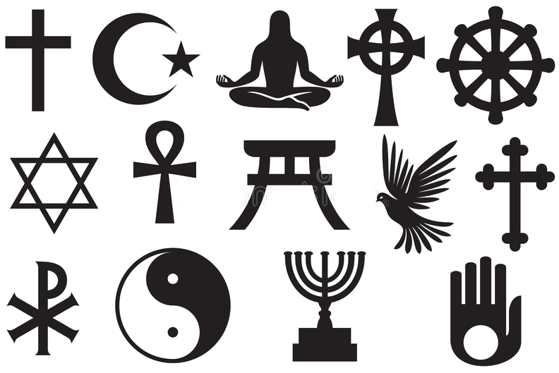
Deutsch-Chinesische Enzyklopädie, 德汉百科
 Israel
 Architecture

 Religion
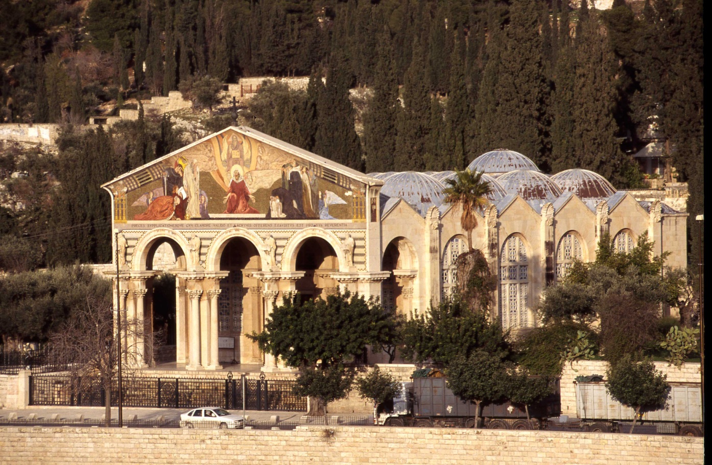
万国教堂(Church of All Nations),又名Agony教堂,位于耶路撒冷城东部的橄榄山,毗邻客西马尼园。 耶稣在被捕前晚间祷告的地方,万国教堂是世界上四大著名教堂之一。耶稣在被捕前晚间在此祷告,听到神告诉他只能活七天的地方,而内部也有供奉当初耶稣祷告时所坐的石头。 教堂外观上方的马赛克镶嵌画中间红衣服的是耶稣,而他张开双臂代表着在最后七天的生命努力作好上方的主交办他的事项,而主身上的记号则代表起源或结束都来自于主,两旁的信众一边是相信耶稣会带给他希望,另一边则是怀疑他的人民,但最终、两边都会相信他的。 教堂本身在建筑的同时,有发现基底有拜占庭时代遗留下来的遗迹,所以当初建筑教堂的设计师保留原遗迹的马赛克拼贴花式,将教堂完成。 这座教堂建于1919年到1924年,得到许多不同国家的资助(因而得名)。每个国家的标志放置于天花板的玻璃上,每一个都放在一个小dome. 教堂的前面有一排列柱,教堂为拜占庭风格建筑,有圆顶、粗大的列柱和镶嵌图案。该教堂的建筑师是Antonio Barluzzi。
现存教堂时间在两座古代教堂的基础上-12世纪十字军教堂(1345年废弃)和4世纪的拜占庭教堂(毁于746年地震)。
Die Kirche aller Nationen (lat. Basilica Agoniae Domini; auch Kirche der Nationen oder Todesangstbasilika) ist ein römisch-katholischer Sakralbau im Garten Getsemani am Fuße des Ölbergs in Jerusalem und gehört zum Lateinischen Patriarchat von Jerusalem.
Nach Matthäus 26,36–46 EU und Markus 14,25–42 EU hat Jesus von Nazareth an dieser Stelle im Bewusstsein des Bevorstehenden gebetet, bevor er von Judas Iskariot verraten wurde. Besonders bezieht sich die Kirche auf die nur bei dem Evangelisten Lukas 22,44 EU überlieferte Stelle: „Und er betete in seiner Angst noch inständiger und sein Schweiß war wie Blut, das auf die Erde tropfte.“ Dieses Blutschwitzen wird als Hinweis auf die Todesangst Jesu und sein auch menschliches Wesen angesehen.
Die Kirche wurde zwischen 1919 und 1924 mit Geldern aus zwölf Ländern erbaut. Daher rührt auch der Name Kirche der Nationen.[2] Das Wappen jedes der beteiligten Länder ist in einer eigenen Sektion an der Decke der Kirche zu finden. Die dreischiffige Kirche hat die klassische Basilika-Form ohne Turm, aber zwölf Kuppeln, die für die zwölf Apostel stehen, die von sechs rotbraunen Säulen als Symbol für die Ölbäume getragen werden.[3] Der Innenraum ist passend zum Thema Todesangst verhältnismäßig düster. Der Altar steht vor dem Felsen, auf dem Jesus gebetet haben soll, und ist mit einem Gitter umgeben, das an die Dornenkrone erinnert.
Die heutige Kirche steht auf den Fundamenten einer byzantinischen Basilika aus dem 4. Jahrhundert, erbaut durch Kaiser Theodosius I., die im Jahre 746 bei einem Erdbeben zerstört wurde, und einer Kreuzfahrerkirche aus dem 12. Jahrhundert, die 1345 zerstört wurde. Teile des ursprünglichen Fußbodens sind noch heute in der Kirche sichtbar.
The Church of All Nations, also known as the Church or Basilica of the Agony, is a Roman Catholic church located on the Mount of Olives in Jerusalem, next to the Garden of Gethsemane. It enshrines a section of bedrock where Jesus is said to have prayed before his arrest. (Mark 14:32-42)
The current church rests on the foundations of two earlier ones, that of a small 12th century Crusader chapel abandoned in 1345, and a 4th-century Byzantine basilica, destroyed by an earthquake in 746. In 1920, during work on the foundations, a column was found two meters beneath the floor of the medieval crusader chapel. Fragments of a magnificent mosaic were also found. Following this discovery the architect immediately removed the new foundations and began excavations of the earlier church. After the remains of the Byzantine era church were fully excavated plans for the new church were altered and work continued on the current basilica from April 19, 1922 until June 1924 when it was consecrated.
L’église de Toutes-les-Nations (également appelée basilique de l’Agonie, Basilica Agoniæ Domini) est une église catholique située au pied du mont des Oliviers à Jérusalem, au lieu-dit « Gethsémani ». Construite de 1922 à 1924, elle renferme le rocher au pied duquel, selon la tradition, Jésus pria durant son agonie, avant son arrestation (Luc 22 :41)
La chiesa di tutte le Nazioni è una chiesa di Gerusalemme, posta sul monte degli Ulivi, in quello che la tradizione riconosce come il Getsemani.
Essa è costruita sul luogo dove, a partire dal IV secolo, esisteva un luogo di culto bizantino, trasformato poi dai crociati in basilica, andata in rovina con la definitiva occupazione islamica.
Il nome della chiesa ricorda il contributo di numerosi paesi alla sua costruzione, avvenuta tra il 1919 ed il 1924 ad opera dell'architetto italiano Antonio Barluzzi. La chiesa è conosciuta anche come chiesa dell'agonia in riferimento alla notte che Gesù vi trascorse alla vigilia del suo arresto. In essa sono armoniosamente fusi assieme elementi architettonici tipici delle basiliche cristiane (per esempio la facciata) con tratti tipici degli edifici islamici (per esempio la copertura caratterizzata da numerose piccole cupole).
La Basílica de Getsemaní, también conocida como Basílica de las Naciones o de la Agonía, es un templo católico situado en el Monte de los Olivos de Jerusalén, junto al jardín de Getsemaní. En su interior se encuentra la porción de roca en la que, según la tradición, Jesús oró la noche de su arresto, después de celebrar la Última Cena.1
La basílica descansa sobre los cimientos de dos templos anteriores, una basílica bizantina del siglo IV, destruida por un terremoto en el año 746 y una capilla cruzada del siglo XII, abandonada en 1345.23 Las obras del edificio actual, diseñado por el arquitecto Antonio Barluzzi,1 se llevaron a cabo entre 1919 y 19244 empleando fondos provenientes de distintos países (de ahí su apelativo de las naciones), cuyos símbolos aparecen en los mosaicos del techo en recuerdo de su contribución en la construcción.1El frontal de la iglesia es una fachada de estilo neobizantino, con una serie de pilares. Como remate, un mosaico mostrando simbólicamente a Jesucristo como enlace entre Dios y la humanidad. El techo en forma de burbujas, los pilares anchos y el mosaico refuerzan la apariencia arquitectónica bizantina de la iglesia.
La basílica se encuentra regida por la Custodia de Tierra Santa de la Orden Franciscana, que en un gesto de ecumenismo, también permite a la comunidad anglicana utilizar un altar en el huerto de Getsemaní para celebrar sus servicios de Jueves Santo.2
Церковь Всех Наций или Бази́ли́ка Аго́нии Госпо́дней (лат. Basilica Agoniae Domini) — францисканский католический храм в Гефсиманском саду, построенный на том месте, где, согласно преданию, Иисус Христос совершил Моление о чаше (Мк. 14:32-42) в последнюю ночь перед арестом. Церковь освящена в честь Страстей (Страданий) Господних.
Расположена у подножия Елеонской горы в Восточном Иерусалиме.
Церковь сооружена в 1924 году на месте более ранних церквей по проекту итальянского архитектора Антонио Барлуцци на деньги католиков 12 стран мира (Аргентина, Бельгия, Бразилия, Канада, Чили, Великобритания, Франция, Германия, Италия, Мексика, Испания и США), в честь чего и получила своё популярное название — церковь Всех наций[1]. В честь этих стран церковь имеет 12 куполов[2].
Камень, на котором, по преданию, Иисус Христос совершил Моление о чаше расположен в алтаре церкви и окружен железной кованной оградой в виде терновых венцов (подарок Австралии).
Снаружи к церкви примыкает камень, на котором находится вырезанное из камня изображение молящегося Христа[3].
Поскольку церковь принадлежит католикам, то прочие христианские конфессии для служб в Гефсиманском саду используют открытый алтарь, расположенный около храма.
 History

 Hand in Hand
 Afghanistan
Egypt
Azerbaijan
Bahrain
China
India
Iraq
Iran
Israel
Jordan
Cambodia
Kasachstan
Kyrgyzstan
Afghanistan
Egypt
Azerbaijan
Bahrain
China
India
Iraq
Iran
Israel
Jordan
Cambodia
Kasachstan
Kyrgyzstan
 Mongolei
Pakistan
Palestine
Republic of Korea
Russia
Tajikistan
Thailand
Turkey
Uzbekistan
United Arab Emirates
Vietnam
Mongolei
Pakistan
Palestine
Republic of Korea
Russia
Tajikistan
Thailand
Turkey
Uzbekistan
United Arab Emirates
Vietnam


Das Konservative Judentum oder Masorti-Judentum (zu hebräisch מסורתי masorti, deutsch ‚traditionell‘) (englisch Conservative Judaism oder Masorti Judaism) ist eine im 19. Jahrhundert entstandene Denomination des Judentums, die aus der Positiv-Historischen Schule der Rabbiner Zacharias Frankel, Michael Sachs und Solomon Schechter hervorging.[1]
Die Bewegung, die sich zwischen dem orthodoxen Judentum und dem liberalen Judentum angesiedelt sehen möchte, hat verschiedene Gesetze und Praktiken des als orthodox bezeichneten Judentums, wie auch die liberalen jüdischen Strömungen, nach ihren Bedürfnissen reformiert.
犹太教保守派(英语:Conservative Judaism/ Masorti Judaism),是犹太教中介于正统派和改革派之间的温和派,其前身是德国的犹太教历史学派。
犹太教保守派起源于很多居于欧洲的犹太人对犹太教改革派的极端革新感到的不安。十九世纪末期,保守派运动兴起,强调犹太传统中良好的历史质素。所罗门·谢克特(Solomon Schechter, 1850-1915)成为此运动的领导人物,他强调忠心于传统的重要,指出只要在需要的时候才作更改。谢克特强调保存犹太民族才是维护其传统及作出改善的唯一方法。基层的人的影响力不容忽视,其势力在推动改革方面尤为显著,例如,不同的会众可以独立决定应否采用乐器及遵守洁净条例。
犹太教保守派原则上接受犹太教律法,却认为其宗教的意义不应拘泥于形式而在于实践其中的精神。而《妥拉》是上帝在西奈山上授予给摩西的,但不是不变的真理,应因实情况不断变化,《塔木德》亦应灵活变通的实行。
 Party and government

 Sport
Sport


*Mediterranean Sea
Egypt
Albania
Algeria
Amber Road
Bosnia Herzegovina
France
Gibraltar
Greece
Israel
Italy
Croatia
Libanon
Libya
Malta
Malta
Monaco
Montenegro
Palestine
 Review
Slovenia
Spain
Syria
Tunisia
Turkey
Cyprus
Review
Slovenia
Spain
Syria
Tunisia
Turkey
Cyprus


Yad Eliyahu Sports Arena (1963–2003)
Nokia Arena (2003–2014)
Heimspielbetrieb Maccabi Tel Aviv (Ligat ha’Al, seit 1964) Hapoel Tel Aviv (Ligat ha’Al, 2005–2006, seit 2025) Veranstaltungen Final-Four-Turnier der israelischen Basketballmeisterschaft Final-Four-Turnier des israelischen Basketball-Staatspokals Spiele der israelischen Basketballnationalmannschaft Endspiel im Basketball-Europapokal der Landesmeister 1972 Final-Four-Turnier des Europapokals der Landesmeister 1994 All-Star Game FIBA EuroStars 1997 Final-Four-Turnier der EuroLeague 2004 Basketball-Europameisterschaft der Damen 2023
 Geography
*Mediterranean Sea
Egypt
Albania
Algeria
Amber Road
Bosnia Herzegovina
France
Gibraltar
Greece
Israel
Italy
Croatia
Libanon
Libya
Malta
Morocco
Monaco
Montenegro
Palestine
Slovenia
Spain
Syria
Tunisia
Turkey
Cyprus
Geography
*Mediterranean Sea
Egypt
Albania
Algeria
Amber Road
Bosnia Herzegovina
France
Gibraltar
Greece
Israel
Italy
Croatia
Libanon
Libya
Malta
Morocco
Monaco
Montenegro
Palestine
Slovenia
Spain
Syria
Tunisia
Turkey
Cyprus
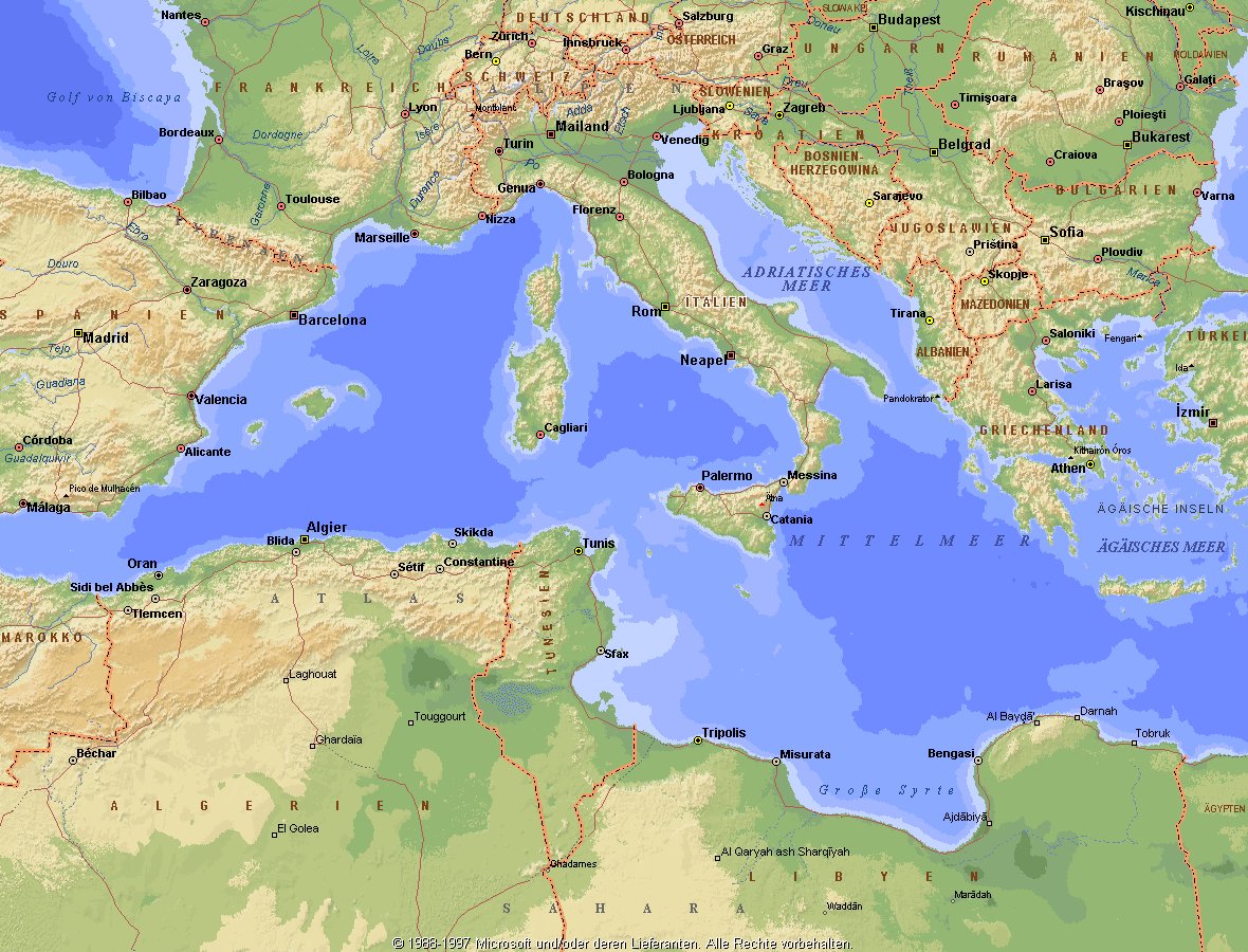
地中海,由北面的欧洲大陆,南面的非洲大陆以及东面的亚洲大陆包围着。东西长约4000千米,南北最宽处大约为1800千米,面积251.6万平方千米,是世界最大的陆间海。地中海的平均深度是1500米,最深处为5267米。
地中海西部通过直布罗陀海峡与大西洋相接,东部通过土耳其海峡(达达尼尔海峡和博斯普鲁斯海峡、马尔马拉海)和黑海相连。19世纪时开通了的苏伊士运河,接通了地中海与红海。 地中海是世界上最古老的海之一,[3] 而其附属的大西洋却是年轻的海洋。地中海处在欧亚板块和非洲板块交界处,是世界最强地震带之一。地中海地区有维苏威火山、埃特纳火山。
地中海作为陆间海,风浪较小,加之沿岸海岸线曲折、岛屿众多,拥有许多天然良好的港口,成为沟通三个大陆的交通要道。这样的条件,使地中海从古代开始海上贸易就很繁盛,促进了古代古埃及文明、古希腊文明、罗马帝国等的发展。现在也是世界海上交通的重要地区之一。其沿岸的腓尼基人、克里特人、希腊人,以及后来的葡萄牙人和西班牙人都是航海业发达的民族。著名的航海家如哥伦布、达·伽马、麦哲伦等,都出自地中海沿岸的国家。
地中海的沿岸夏季炎热干燥,冬季温暖湿润,被称作地中海性气候。植被,叶质坚硬,叶面有蜡质,根系深,有适应夏季干热气候的耐旱特征,属亚热带常绿硬叶林。这里光热充足,是欧洲主要的亚热带水果产区,盛产柑橘、无花果,和葡萄等,还有木本油料作物油橄榄。
Das Mittelmeer (lateinisch Mare Mediterraneum,[1] deshalb deutsch auch Mittelländisches Meer, präzisierend Europäisches Mittelmeer, im Römischen Reich Mare Nostrum) ist ein Mittelmeer zwischen Europa, Afrika und Asien, ein Nebenmeer des Atlantischen Ozeans und, da es mit der Straße von Gibraltar nur eine sehr schmale Verbindung zum Atlantik besitzt, auch ein Binnenmeer. Im Arabischen und Türkischen wird es auch als „Weißes Meer“ (البحر الأبيض/al-baḥr al-abyaḍ bzw. türk. Akdeniz) bezeichnet.
Zusammen mit den darin liegenden Inseln und den küstennahen Regionen Südeuropas, Vorderasiens und Nordafrikas bildet das Mittelmeer den Mittelmeerraum, der ein eigenes Klima (mediterranes Klima) hat und von einer eigenen Flora und Fauna geprägt ist.
地中海(ちちゅうかい、ラテン語: Mare Mediterraneum)は、北と東をユーラシア大陸、南をアフリカ大陸(両者で世界島)に囲まれた地中海盆地に位置する海である。面積は約3000平方キロメートル、平均水深は約1500メートル[2]。海洋学上の地中海の一つ。
地中海には、独立した呼称を持ついくつかの海域が含まれる(エーゲ海、アドリア海など)。地中海と接続する他の海としては、ジブラルタル海峡の西側に大西洋が、ダーダネルス海峡を経た北東にマルマラ海と黒海があり、南西はスエズ運河で紅海と結ばれている(「海域」「地理」で詳述)。
北岸の南ヨーロッパ、東岸の中近東、南岸の北アフリカは古代から往来が盛んで、「地中海世界」と総称されることもある[3]。
The Mediterranean Sea is a sea connected to the Atlantic Ocean, surrounded by the Mediterranean Basin and almost completely enclosed by land: on the north by Southern Europe and Anatolia, on the south by North Africa and on the east by the Levant. Although the sea is sometimes considered a part of the Atlantic Ocean, it is usually identified as a separate body of water. Geological evidence indicates that around 5.9 million years ago, the Mediterranean was cut off from the Atlantic and was partly or completely desiccated over a period of some 600,000 years, the Messinian salinity crisis, before being refilled by the Zanclean flood about 5.3 million years ago.
It covers an approximate area of 2.5 million km2 (965,000 sq mi), but its connection to the Atlantic (the Strait of Gibraltar) is only 14 km (8.7 mi) wide. The Strait of Gibraltar is a narrow strait that connects the Atlantic Ocean to the Mediterranean Sea and separates Gibraltar and Spain in Europe from Morocco in Africa. In oceanography, it is sometimes called the Eurafrican Mediterranean Sea or the European Mediterranean Sea to distinguish it from mediterranean seas elsewhere.[2][3]
The Mediterranean Sea has an average depth of 1,500 m (4,900 ft) and the deepest recorded point is 5,267 m (17,280 ft) in the Calypso Deep in the Ionian Sea. The sea is bordered on the north by Europe, the east by Asia, and in the south by Africa. It is located between latitudes 30° and 46° N and longitudes 6° W and 36° E. Its west-east length, from the Strait of Gibraltar to the Gulf of Iskenderun, on the southwestern coast of Turkey, is approximately 4,000 km (2,500 miles). The sea's average north-south length, from Croatia’s southern shore to Libya, is approximately 800 km (500 miles). The Mediterranean Sea, including the Sea of Marmara (connected by the Dardanelles to the Aegean Sea), has a surface area of approximately 2,510,000 square km (970,000 square miles).[4]
The sea was an important route for merchants and travellers of ancient times that allowed for trade and cultural exchange between emergent peoples of the region. The history of the Mediterranean region is crucial to understanding the origins and development of many modern societies.
The countries surrounding the Mediterranean in clockwise order are Spain, France, Monaco, Italy, Slovenia, Croatia, Bosnia and Herzegovina, Montenegro, Albania, Greece, Turkey, Syria, Lebanon, Israel, Egypt, Libya, Tunisia, Algeria, and Morocco; Malta and Cyprus are island countries in the sea. In addition, the Gaza Strip and the British Overseas Territories of Gibraltar and Akrotiri and Dhekelia have coastlines on the sea.
La mer Méditerranée (prononcé [me.di.tɛ.ʁa.ne]) est une mer intercontinentale presque entièrement fermée, bordée par les côtes d'Europe du sud, d’Afrique du Nord et d’Asie, depuis le détroit de Gibraltar à l'ouest aux entrées des Dardanelles et du canal de Suez à l'est. Elle s’étend sur une superficie d’environ 2,5 millions de kilomètres carrés. Son ouverture vers l’océan Atlantique par le détroit de Gibraltar est large de 14 kilomètres.
Elle doit son nom au fait qu’elle est littéralement une « mer au milieu des terres », en latin « mare medi terra »1.
Durant l’Antiquité, la Méditerranée était une importante voie de transports maritimes permettant l’échange commercial et culturel entre les peuples de la région — les cultures mésopotamiennes, égyptienne, perse, phénicienne, carthaginoise, berbère, grecque, arabe (conquête musulmane), ottomane, byzantine et romaine. L’histoire de la Méditerranée est importante dans l’origine et le développement de la civilisation occidentale.
Il mar Mediterraneo, detto brevemente Mediterraneo, è un mare intercontinentale situato tra Europa, Nordafrica e Asia occidentale connesso all'Oceano Atlantico. La sua superficie approssimativa è di 2,51 milioni di km² e ha uno sviluppo massimo lungo i paralleli di circa 3 700 km. La lunghezza totale delle sue coste è di 46 000 km, la profondità media si aggira sui 1 500 m, mentre quella massima è di 5 270 m presso le coste del Peloponneso. La salinità media si aggira dal 36,2 al 39 ‰.[2] La popolazione presente negli stati bagnati dalle sue acque ammonta a circa 450 milioni di persone.[2].
El mar Mediterráneo es uno de los mares del Atlántico. Está rodeado por la región mediterránea, comprendida entre Europa meridional, Asia Occidental y África septentrional. Fue testigo de la evolución de varias civilizaciones como los egipcios, los fenicios, hebreos, griegos, cartagineses, romanos, etc. Con aproximadamente 2,5 millones de km² y 3.860 km de longitud, es el segundo mar interior más grande del mundo, después del Caribe.1 Sus aguas, que bañan las tres penínsulas del sur de Europa (Ibérica, Itálica, Balcánica) y una de Asia (Anatolia), comunican con el océano Atlántico a través del estrecho de Gibraltar, con el mar Negro por los estrechos del Bósforo y de los Dardanelos y con el mar Rojo por el canal de Suez.2 Es el mar con las tasas más elevadas de hidrocarburos y contaminación del mundo.3
Средизе́мное мо́ре — межматериковое море, по происхождению представляющее собой глубоководную псевдоабиссальную внутришельфовую депрессию[1][2], связанную на западе с Атлантическим океаном Гибралтарским проливом[3].
В Средиземном море выделяют, как его составные части, моря: Адриатическое, Альборан, Балеарское, Ионическое, Кипрское, Критское, Левантийское, Ливийское, Лигурийское, Тирренское и Эгейское. В бассейн Средиземного моря также входят Мраморное, Чёрное и Азовское моря.