
漢德百科全書 | 汉德百科全书
 Important port

Neu-Delhi (englisch New Delhi; Hindi नई दिल्ली IAST Naī Dillī; Urdu نئی دہلی; Panjabi ਨਵੀਂ ਦਿੱਲੀ) ist die Hauptstadt Indiens, Sitz der indischen Regierung, des Parlaments und der obersten Gerichte. Neu-Delhi ist ein relativ kleiner Teil der Megastadt Delhi, der mit 31,87 Millionen Einwohnern drittgrößten Metropolregion der Welt (Stand 2021),[2] und verfügt innerhalb des Nationalen Hauptstadtterritoriums Delhi über eine eigene Kommunalverwaltung, die 2011 ein Gebiet mit rund 250.000 Einwohnern umfasste.
Der Grundstein Neu-Delhis wurde während der Kolonialzeit am 15. Dezember 1911 südlich des damaligen Stadtzentrums Shahjahanabad gelegt, um Calcutta als Hauptstadt Britisch-Indiens abzulösen.[3]
Das Verhältnis zwischen den Namen Delhi und Neu-Delhi ist komplex. Neu-Delhi ist ein Teil der Metropole Delhi, die als National Capital Territory of Delhi („Nationales Hauptstadtterritorium Delhi“) von der indischen Zentralregierung mitverwaltet wird. Im engeren Sinn bezeichnet Neu-Delhi nur das während der britischen Kolonialzeit planmäßig angelegte Regierungsviertel, welches lediglich einen sehr kleinen Teil des Hauptstadtterritoriums umfasst und im Wesentlichen mit den Grenzen der kommunalen Verwaltungseinheit Neu-Delhi übereinstimmt. Mit dem davon zu unterscheidenden Distrikt Neu-Delhi besteht aber noch eine weitere administrative Einheit gleichen Namens mit anderer Grenzziehung.
Im alltäglichen Sprachgebrauch wird Neu-Delhi oft erheblich weiter gefasst. Als Neu-Delhi gegründet wurde, bestand Delhi in erster Linie aus der ummauerten Altstadt von Shahjahanabad (Old Delhi, Alt-Delhi). Durch das rasante Bevölkerungswachstum wurden nach der indischen Unabhängigkeit nach und nach auch die umliegenden, einstmals ländlichen Gebiete urbanisiert. Diese „neuen“ Teile Delhis werden entsprechend auch häufig zu Neu-Delhi gezählt. Heute wird die Bezeichnung Neu-Delhi somit oft komplementär zu Alt-Delhi für alle Gebiete Delhis außerhalb von Shahjahanabad benutzt. Vielfach sind die Namen Delhi und Neu-Delhi aber auch gänzlich austauschbar.
新德里(又译纽德里,印地语:नई दिल्ली;英语:New Delhi)是印度的首都,印度联邦政府所在地,也是印度大都市区德里的一个区。它位于印度西北部,座落在恒河支流亚穆纳河西岸,东北紧连旧德里(沙贾汉纳巴德)。整个德里国家首都辖区面积1,482平方公里,人口1,637万(2011年);其中新德里人口1,337万。2013年4月“世界城市区域研究”(Demographia World Urban Areas)发布第9届调查报告,世界大都市依照人口数排名第4,约2,282万人。[4]新德里是全国的政治、经济和文化中心。新德里是典型的放射型城市,城市以姆拉斯广场为中心,城市街道成辐射状、蛛网式地伸向四面八方。宏伟的建筑群大多集中于市中心。政府主要机构集中在市区从总统府到印度门之间绵延几公里的宽阔大道两旁。国会大厦为大圆盘式建筑,四周绕以白色大理石高大圆柱,是中亚式的建筑,屋檐和柱头的雕饰又为印度风格。总统府屋顶为巨大的半球形结构,带有莫卧儿王朝的遗风。城市西端的康瑙特市场建筑新巧,呈圆盘形,是新德里的最大商业中心。新德里还是全国交通的中心,有5条国家级公路、6条铁路与各地相通,还建有两座机场。新德里的奠基石是乔治五世在1911年德里杜尔巴期间奠定的。它由英国建筑师埃德温·鲁琴斯爵士和赫伯特·贝克爵士设计。新首都于1931年2月13日由印度总督艾文勋爵揭幕。
 Financial
 ***Global Financial Center
 History
M 1500 - 2000 AD
History
N 2000 - 2100 AD
History
M 1500 - 2000 AD
History
N 2000 - 2100 AD
 International cities
***Global Urban Economic Competitiveness
Silk road
Singapore
Important port
International cities
***Global Urban Economic Competitiveness
Silk road
Singapore
Important port

Singapur (amtlich Republik Singapur, englisch Republic of Singapore [ɹɪˈpʰʌb.lɪkʰ.əv.ˈsɪŋ.(g)ə.pʰɔː], malaiisch Republik Singapura, chinesisch 新加坡共和国, Pinyin Xīnjiāpō Gònghéguó, auch: 新加坡 [ɕin.tɕiɑ.pʰuɔ], Tamil சிங்கப்பூர் குடியரசு Ciṅkappūr Kudiyarasu) ist ein Insel- und Stadtstaat und der flächenmäßig kleinste Staat Südostasiens. Er ist Mitglied im Commonwealth of Nations.
Beim Index der menschlichen Entwicklung belegte Singapur 2018 den neunten Platz.[6] Singapur ist eines der reichsten Länder (und Städte) weltweit und gilt als eine der Städte mit den weltweit höchsten Lebenshaltungskosten.[7] Zudem zählt der Stadtstaat mit mehr als elf Millionen ausländischen Touristen im Jahr zu den zehn meistbesuchten Städten der Welt[8] und gilt neben Hongkong als wichtigster Finanzplatz Asiens. Singapur ist ein multiethnischer Staat, in dem Chinesen, Malaien und Inder die größten Bevölkerungsteile stellen.
新加坡共和国(英语:Republic of Singapore;马来语:Singapura;泰米尔语:சிங்கப்பூர் குடியரச),通称新加坡,是东南亚中南半岛南端的一个城邦岛国、城市国家。该国位于马来半岛南端,扼守马六甲海峡最南端出口,其南面有新加坡海峡与印尼相隔,北面有柔佛海峡与西马来西亚相隔,并以新柔长堤与第二通道等这两座桥梁相连于新马两岸之间。新加坡的国土除了新加坡本岛之外,还包括周围所属岛屿,新加坡最大的外岛为德光岛。从新加坡独立以来,大规模的填海已经为新加坡增加了23%的面积,相等于增加了130平方公里。
1819年,任职于英国不列颠东印度公司的斯坦福·莱佛士与柔佛苏丹签订条约,获准在新加坡建立交易站和殖民地,经莱佛士的努力,逐渐发展成繁荣的转口港。由于地理位置特殊,新加坡在第二次世界大战以前一直是大英帝国在东南亚最重要的战略据点。1942年至1945年间,新加坡曾被日本占领三年半之久,其后回归英国管理,并从海峡殖民地独立出来,1959年成立自治邦,1963年加入马来西亚成为一个州,称为新加坡州(简称星州)。1965年8月9日,马来西亚国会以126票赞成、0票反对,同意将新加坡驱逐出联邦。新加坡共和国正式成立,李光耀为总理,尤索夫·伊萨为总统。新加坡被驱逐马来西亚后独立建国。
自1965年独立后,新加坡从穷困潦倒中,依靠着国际贸易和人力资本的操作,迅速转变成为富裕的亚洲四小龙之一,同时凭借着地理优势,新加坡也是亚洲重要的金融、服务和航运中心之一。教育素质良好的国民也是亚洲政治和科学文化的纽带,大多数的新加坡人都通晓至少两种语言,分别是英语以及自己的母语。新加坡是个多元文化种族的社会,也是全球最国际化的国家之一,所以主要由华人组成的新加坡并非为单一民族国家,而是和一部分马来人及印度人所组成的移民国家,其中华人文化以福建移民为大宗[6]。在国内居住的居民有38%为永久居民、持有工作签证的外籍劳工以及持有学生签证的学生,建筑业和服务业的外劳比例分别为80%和50%[7][8][9][10]。整个城市在绿化和环境卫生方面效果显著,故有花园城市之美称。
シンガポール共和国(シンガポールきょうわこく、英語: Republic of Singapore、マレー語: Republik Singapura、簡体字: 新加坡共和国、繁体字: 新加坡共和國、タミル語: சிங்கப்பூர் குடியரசு)、通称シンガポールは、東南アジアに位置し、シンガポール島及び60以上の小規模な島々からなる共和制国家[4]。
同国は、北はジョホール海峡により半島マレーシアから、南はシンガポール海峡によりインドネシアのリアウ諸島州から各々切り離されている。同国は高度に都市化され、原初の現存植生はほとんどない。シンガポールの領土は、一貫して埋立てにより拡大してきた。
シンガポールは、教育・エンターテインメント・金融・ヘルスケア・人的資本・イノベーション・ロジスティクス・製造・技術・観光・貿易・輸送の世界的な中心である。多くの国際順位で格付けされており、最も「テクノロジー対応」国(WEF)、国際会議のトップ都市(UIA)、世界で最もスマートな都市である「投資の可能性が最も高い」都市(BERI)、世界で最も安全な国、世界で最も競争力のある経済、3番目に腐敗の少ない国、3番目に大きい外国為替市場、3番目に大きい金融センター、3番目に大きい石油精製貿易センター、5番目に革新的な国、2番目に混雑するコンテナ港湾。2013年以来、エコノミストはシンガポールを「最も住みやすい都市」として格付けしている[5][6][7][8]。
シンガポールは、すべての主要な格付け機関からAAAソブリン格付けを持つ、アジアで唯一の国であり、世界11か国のうちの1つである。シンガポール航空は2018年の「世界最高の航空会社」であり、世界的にはシンガポール港とチャンギ国際空港がそれぞれ「マリタイムキャピタル」と「ベスト空港」のタイトルを連続して獲得している[9][10]。
シンガポールは、1人当たりGDPが2番目に高く、国連人間開発指数で9位である、主権国にとってアジアで最高。これは、教育・医療・平均余命・生活の質・個人の安全・住宅などの主要な社会的指標に高く置かれており、人口の90%が家の所有者である。
Singapore (/ˈsɪŋ(ɡ)əpɔːr/ ( listen)), officially the Republic of Singapore, is a sovereign city-state and island country located in maritime Southeast Asia. Singapore lies about one degree of latitude (137 kilometres or 85 miles) north of the equator, and is situated off the southern tip of the Malay peninsula, and, by extension, the southernmost extremity of continental Eurasia. The island country is wedged between western Indonesia and peninsular Malaysia, sharing its southern maritime border with the Batam, Bintan, and Karimun archipelago of the former's Riau Islands province, and its northern, western, and eastern maritime borders with the latter's Johor state; it is additionally in the vicinity of Sumatra to its west and Borneo to its east. The island country is enveloped by the littoral waters of the Johore Strait to its north and the Singapore Strait to its south, and is geographically positioned within the confluence of the Indian and Pacific Oceans, being bounded by the Malacca Strait to its west and the South China Sea to its east. The country's territory, which is archipelagic, is composed of one main island, 63 satellite islands and islets, and one outlying islet, the combined area of which has increased by 25% since the country's independence as a result of extensive land reclamation projects.
Throughout its millennia-long history, Singapore—historically known by the names Pulau Ujong, Temasek, and subsequently Singapura—was a maritime emporium that fell under the suzerainty of several successive Indianised and Islamicate Malay polities: initially a series of ancient to medieval Hindu-Buddhist thalassocratic empires, subsequently a medieval localised Hindu-Buddhist kingdom, and ultimately two medieval to early modern Islamic sultanates.[14][Note 8] The 1819 arrival of Stamford Raffles, a British colonial officer, and the subsequent establishment of a British East India Company trading post on the main island—then part of the Johor Sultanate—marked the genesis of modern Singapore. Five years later, the British and Dutch East India companies partitioned the Sultanate, with the British coercively wresting Singapore from the Sultan in the process, marking the cessation of indigenous rule over the island for the first time in its history. In 1826, Singapore was incorporated into the Straits Settlements, a pan-Malayan presidency of the Company with Penang as capital,[15][Note 9] and in 1830, the Settlements were annexed to British India as a residency, where they would be governed from the capital of Calcutta under two administrations—until 1858 under Company rule, and—following the Company's collapse in the wake of the 1857 Indian Rebellion—until 1867 under the successive British Raj. In 1867, the administration of the Settlements was transferred to London, bringing them under the direct control of the United Kingdom as a Malayan crown colony.[16][17][18]
From 1867 to the 1940s, Singapore, having taken over Penang as capital of the Settlements, grew into a thriving entrepôt and settler-colony under the auspices of the British Empire, attracting large numbers of non-indigenous settlers and sojourners from the region and beyond.[19] During the Second World War, Imperial Japan invaded and annexed Singapore, resulting in an interregnum of British colonial rule corresponding with a brief but bloody Japanese occupation from 1942 to 1945. Following Japan's surrender in 1945, Singapore was returned to British control; in 1946, the Straits Settlements were dissolved, and Singapore became a standalone crown colony. In 1959, following a protracted period of agitation against colonial rule, Singapore was granted limited autonomy; in 1963, it became fully emancipated from the British Empire upon its federation with the territories of the erstwhile British Malaya and British Borneo to form the new country of Malaysia.[Note 10] However, after two tumultuous years as a constituent state of the Malaysian Federation, marred by violent ethnoreligious strife and other intractable differences between indigenous and non-indigenous groups, Singapore was expelled in 1965, becoming the first country in modern history to gain independence against its will—although this narrative remains contentious.[Note 11] After early years of turbulence, the newly sovereign nation—viewed as a nonviable state by international observers due to its diminutiveness, geostrategic vulnerability, absence of natural resources, and lack of a hinterland—defied odds by rapidly developing and industrialising under the leadership of the inaugural People's Action Party to become a high-income economy and developed country within a single generation.
Singapore is a unitary parliamentary constitutional republic with a unicameral legislature that has been characterised by dominant-party rule since independence. It is considered a soft authoritarian technocratic state; the Economist Intelligence Unit rated Singapore a "flawed democracy" in 2019.[21] It is the only truly sovereign city-state in the world; it has its own currency and a well-funded military that is considered the most advanced in Southeast Asia.[22] The country is home to 5.6 million residents, 61% (3.4 million) of whom are Singaporeans; as a legacy of its historical nature as an entrepôt and settler-colony, modern Singapore is a pluralistic country with a racially, culturally, and religiously diverse citizenry,[23][24] with one indigenous ethnic group, the Malays, and two settler-descended ethnic groups, the Chinese and Indians, forming the historical and contemporary core of the citizen populace. As a reflection of this pluralism, multiracialism has been enshrined as a foundational principle of the state, and has shaped the country's politics and national policies. The country, which is Anglophone, has four official languages: English, Malay, Chinese, and Tamil; Malay, as the ancestral language of the country, is accorded protected status in the country's constitution as the national language, while English is the lingua franca, being spoken as a common tongue by the vast majority of Singaporeans.
Singapore is one of the five founding members of ASEAN, is the headquarters of the Asia-Pacific Economic Cooperation (APEC) Secretariat and Pacific Economic Cooperation Council (PECC) Secretariat,[25] is a member of the United Nations, World Trade Organization, East Asia Summit, Non-Aligned Movement, and the Commonwealth of Nations, and is a recurrent guest invitee to the annual G20 summit;[26] its outsized influence on global affairs, relative to its size, has lead to it being classified as a middle power.[27][28] The country is the most developed sovereign nation in Asia, being ranked 9th on the UN Human Development Index, and has the 7th highest GDP per capita in the world.[29][30] It is also considered by Transparency International to be the most incorruptible nation in Asia, and the fifth most incorruptible worldwide. Singapore is placed highly in key social indicators: education, healthcare, quality of life, personal safety and housing, with a home-ownership rate of 91%. Singaporeans enjoy one of the world's longest life expectancies and one of the lowest infant mortality rates in the world.[31] As a city, Singapore is classified as an Alpha+ global city, and is the only country in Asia with an AAA sovereign rating from all major rating agencies. It is a major financial and shipping hub, consistently ranked the most expensive city to live in since 2013, and has been identified as a tax haven.[32][33] Singapore is also a popular tourist destination, with well-known landmarks such as the Merlion, Marina Bay Sands, Gardens by the Bay, the Jewel, the Orchard Road shopping belt, the resort island of Sentosa, and the Singapore Botanic Gardens, the only tropical garden in the world to be honoured as a UNESCO World Heritage Site.[34][35]
Singapour, en forme longue la république de Singapour (en anglais : Singapore et Republic of Singapore, en chinois : 新加坡 (Xīnjiāpō) et 新加坡共和国 (Xīnjiāpō Gònghéguó), en malais : Singapura et Republik Singapura, en tamoul : சிங்கப்பூர் (Ciṅkappūr) et சிங்கப்பூர் குடியரசு) (Ciŋkappūr Kudiyarasu), est une cité-État d’Asie du Sud-Est. Sa superficie est de 719,1 km2. Elle comprend 63 îles, dont la principale est Pulau Ujong (584,8 km2). Cette île est très densément urbanisée, mais la végétation luxuriante – même en plein centre-ville – a valu à Singapour le surnom de « ville jardin ». Cette abondance de verdure découle en partie d'un climat équatorial, uniformément chaud et orageux tout au long de l'année. Sa densité de population est la plus élevée d'Asie et la deuxième sur le plan mondial.
L'État de Singapour est situé à l'extrême sud de la péninsule Malaise, dont il est séparé au nord par le détroit de Johor, et borde au sud le détroit de Singapour. Il est connu et souvent montré en exemple pour son extraordinaire réussite économique. Après l'indépendance de l'Empire britannique en 1958, le rattachement à la Malaisie en 1963, puis l'indépendance en 1965, Singapour a su devenir, avec très peu de ressources naturelles et des problèmes socio-économiques importants – émeutes raciales, chômage massif, difficultés de logement et d'accès à l'eau –, l'un des pays les plus développés et les plus prospères du monde, en termes d'économie, d'éducation, de santé, de sécurité et d'urbanisme. La ville, cité souveraine, est un réduit chinois au cœur même du monde malais : la population est majoritairement composée de Chinois (74,3 %). De cette confrontation ethnique sont nés en partie les troubles qui ont accéléré son retrait de la Malaisie, le 9 août 19656.
Dans les années 1980, le pays fait partie, avec Hong Kong, la Corée du Sud et Taïwan, des quatre dragons asiatiques, des États en transition et au développement économique effréné. En 2011, Singapour est le troisième pays au monde en termes de produit intérieur brut à parité de pouvoir d'achat (PPA) par habitant après le Qatar et le Luxembourg7. Plaque tournante commerciale et financière entre la zone Pacifique et l'Europe, la ville doit son essor à sa situation maritime exceptionnelle à l'extrémité Est du détroit de Malacca, qui lui vaut le surnom de : Cité marchande aux confins de l'Orient. Elle possède le deuxième port au monde (après Shanghai) en termes d'exportations et de trafic maritime. La population singapourienne dispose d'un très haut niveau de vie et la Cité-État est souvent surnommée La Suisse d'Asie8. En 2009, Singapour affichait ainsi la plus forte concentration de millionnaires rapportés à la population totale devançant Hong Kong (Chine), la Suisse, le Qatar et le Koweït9.
Présentant une stabilité politique remarquable, Singapour est considéré aujourd'hui comme une « démocratie autoritaire » ou « dictature bienveillante », avec la même famille au pouvoir depuis l'indépendance. La cité-État est donc considérée comme un pays pratiquant le libéralisme économique sans le libéralisme politique.
Le centre-ville est situé dans le sud de l'île de Pulau Ujong, à l'embouchure de la rivière Singapour (Singapore River). Il comprend un centre d'affaires qui a fait de la ville la quatrième place financière au monde, ainsi que différents quartiers ethniques (chinois, malais, et indien) et une grande zone commerciale autour d'Orchard Road.
Singapore (AFI: /sinɡaˈpore/[5]), ufficialmente Repubblica di Singapore (in malese Republik Singapura; in inglese Republic of Singapore; in cinese 新加坡共和国, Xīnjiāpō Gònghéguó; in tamil சிங்கப்பூர் குடியரசு, Ciŋkappūr Kudiyarasu), è una città-Stato del sud-est asiatico, situata sull'estrema punta meridionale della penisola malese, 152 km a nord dell'equatore. Si sviluppa su un arcipelago formato da 58 isole, la più grande e principale delle quali è l'isola di Singapore che ospita la metropoli. A nord Singapore è separata dalla Malaysia dallo Stretto di Johor, a sud è separata dalle indonesiane isole Riau dallo Stretto di Singapore.
La città-Stato è il quarto principale centro finanziario del mondo[6] ed è una delle principali città cosmopolite del globo, con un importante ruolo nel commercio internazionale e nella finanza. Il suo porto è tra i primi cinque per attività e traffico su scala mondiale.[7]
Singapore è un Paese con una lunga storia di immigrazione. Ha una popolazione variegata e gli oltre 5 milioni di abitanti sono composti prevalentemente da cinesi, malesi, indiani e altre discendenze di asiatici ed europei.[8]
Il 42% della popolazione è straniero, qui presente per lavoro o studio. I lavoratori stranieri costituiscono il 50% del settore dei servizi.[9][10]
Singapore è il secondo Paese più densamente popolato del mondo dopo il Principato di Monaco e nel 2009 ha raggiunto la più alta concentrazione di milionari in rapporto alla popolazione, davanti a Hong Kong, Svizzera, Qatar e Kuwait.[11]
Singapur, oficialmente República de Singapur (en inglés: Republic of Singapore; en chino: 新加坡共和国 [Xīnjīapō Gònghéguó]; en malayo: Republik Singapura; y en tamil: சிங்கப்பூர் குடியரசு [Siṅkappūr Kuṭiyarasu]), es un país soberano insular de Asia, formado por sesenta y tres islas, cuya forma de gobierno es la república parlamentaria.
Su territorio se divide en cinco consejos de desarrollo comunitario. Su capital es la ciudad de Singapur, por lo que Singapur se considera una ciudad-estado. Está situado al sur del Estado de Johor en la península de Malasia y al norte de las islas Riau de Indonesia, separada de estas por el estrecho de Singapur. Con 697 km²,1 es el país más pequeño del Sudeste Asiático. Su territorio ha crecido constantemente con tierras ganadas al mar.
Desde el siglo II d. C., cuando se establecieron allí los primeros humanos, la isla de Singapur ha formado parte de varios imperios regionales. El moderno Singapur fue fundado en 1819 por el británico Thomas Stamford Raffles como puesto comercial de la Compañía Británica de las Indias Orientales con el permiso del Sultanato de Johor. El Reino Unido obtuvo la soberanía sobre la isla en 1824 y esta pasó a ser una de las Colonias del Estrecho británicas en 1826. Ocupada por los japoneses durante la Segunda Guerra Mundial, Singapur declaró su independencia del Reino Unido en 1963 como un estado más de Malasia mediante un referéndum de incorporación, de la que se separó dos años después. Desde entonces la ciudad-estado ha prosperado rápidamente y se ha ganado la distinción de ser uno de los «cuatro tigres asiáticos».
Singapur es una de las principales ciudades globales y uno de los centros neurálgicos del comercio mundial, contando con el tercer mayor centro financiero y el segundo puerto que más mercancías mueve. Su economía globalizada y diversificada depende especialmente del comercio y del sector manufacturero. En términos de paridad de poder adquisitivo, Singapur es el tercer país con mayor renta per cápita del mundo, además de figurar entre los primeros países en las listas internacionales de educación, sanidad, transparencia política y competitividad económica.
Políticamente, Singapur es una república parlamentaria multipartidista con un gobierno parlamentario unicameral inspirado en el sistema Westminster británico. El Partido de Acción Popular ha ganado todas las elecciones desde que el país obtuvo la independencia. Sin embargo, las libertades civiles y de expresión están sumamente restringidas y se dan casos de censura por parte del Gobierno, por lo que está considerado como un país con rasgos tanto democráticos como autoritarios.4 La población, unos cinco millones de habitantes, es muy diversa: alrededor de dos millones son de origen extranjero y entre los nativos, el 75 % son chinos y el resto minorías de malayos, indios o euroasiáticos. Esta diversidad tiene su reflejo en los cuatro idiomas oficiales del país, que son el inglés, el chino, el malayo y el tamil, así como en las políticas gubernamentales que promueven el multiculturalismo.5
Singapur es uno de los miembros fundadores de la Asociación de Naciones del Sudeste Asiático y ha sido sede del secretariado del Foro de Cooperación Económica Asia-Pacífico, además de formar parte de la Cumbre de Asia Oriental, del Movimiento de Países No Alineados y de la Mancomunidad de Naciones. El rápido desarrollo del país lo ha llevado a tener una influencia importante en los asuntos internacionales y a que algunos analistas lo consideren una potencia intermedia.67
Республика Сингапу́р (англ. Republic of Singapore; малайск. Republik Singapura, ريڤوبليق سيڠاڤورا; кит. трад. 新加坡共和國,

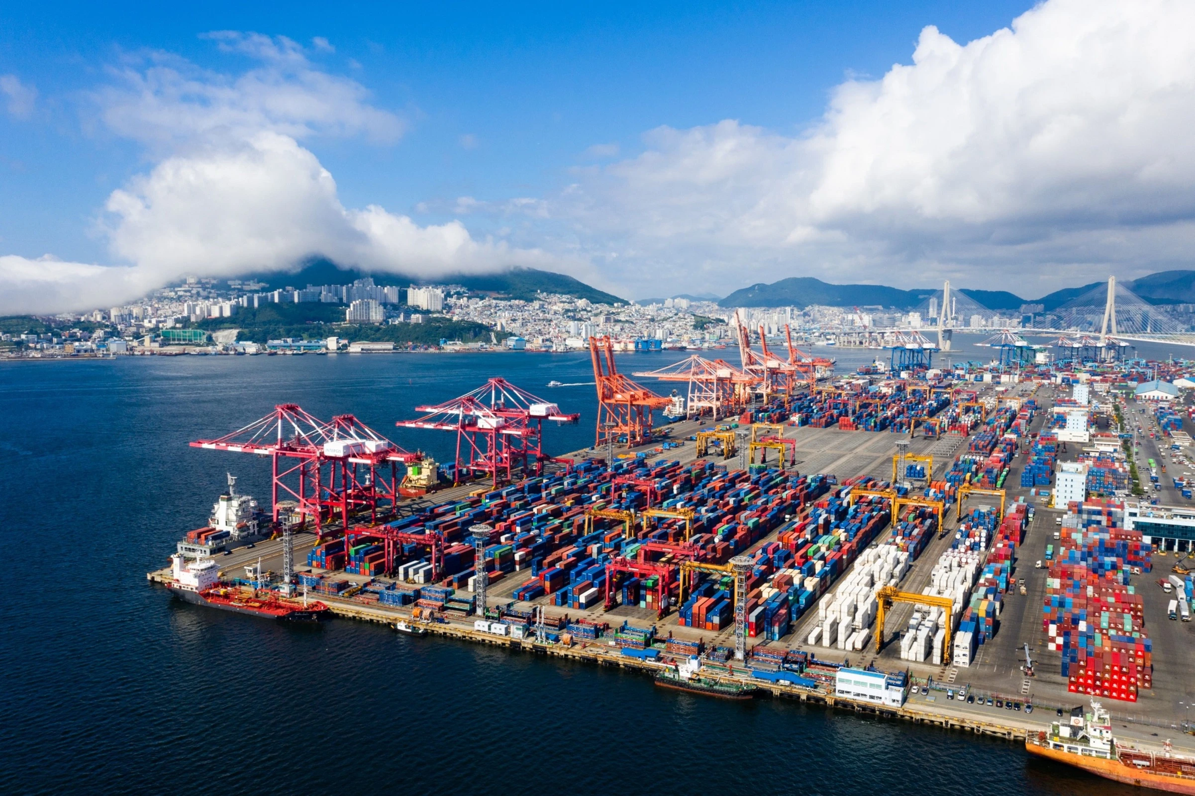
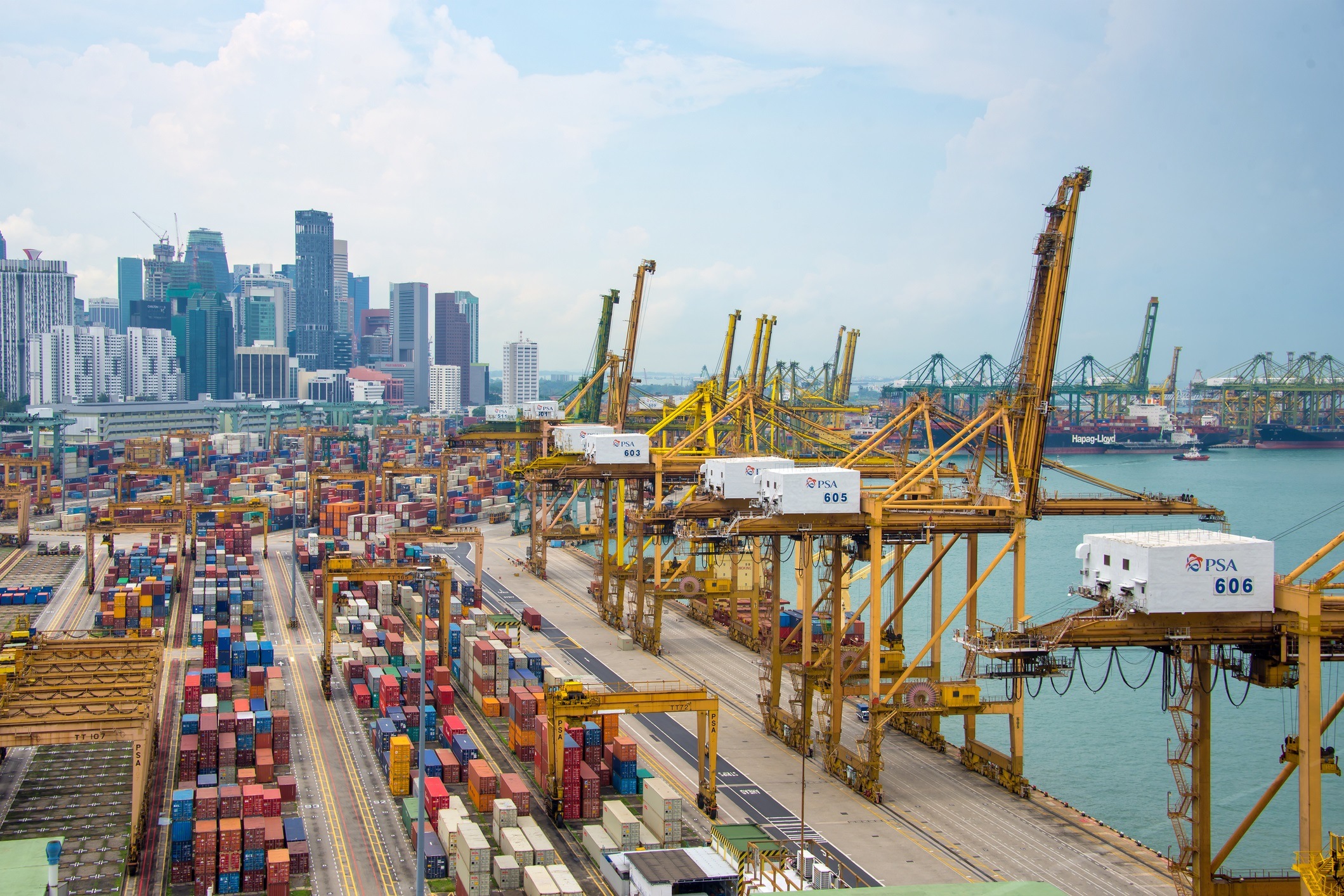
新加坡港,位于新加坡南部沿海,毗邻马六甲海峡,扼太平洋及印度洋之间的航运要道,战略地位十分重要,现以发展成为世界级的物流中心。新加坡港一度为世界上最繁忙的港口,目前是世界上第二繁忙的港口,仅次于上海港,也是全球最繁忙的转运港及燃料补给港。新加坡港在亚洲货运、物流和供应链奖中一直保持“亚洲最佳海港”称号,自2021年起更获选为“全球最佳海港”[2]。
新加坡港由裕廊、吉宝、丹戎巴葛、布拉尼、三巴旺和巴西班让6个主要码头组成,在建中的大士港将成为世界上最大的全自动码头。
Singapur besitzt traditionell aufgrund seiner ausgedehnten Küstenabschnitte und einiger Nebeninseln an der Straße von Singapur mehrere Hafenanlagen. Die gesamte Partie der stark ausgebauten Hafenanlagen erstreckt sich heute an der Südwestküste der Hauptinsel Pulau Ujong und einigen südlich vorgelagerten Nebeninseln über rund 30 Kilometer. Dabei hat sich eine logistisch sinnvolle Arbeitsteilung herausgebildet: Stückgut, Massengüter und Fisch, Öl- und petrochemische Produkte, Container- und Passagierverkehr haben jeweils ihre eigenen Häfen.
Es gibt folgende Häfen in Singapur:
- Frachthäfen
- Port of Singapore, der größte Frachthafen
- Jurong Port
- Keppel Harbour (zwischen Pulau Brani und Sentosa)
- Serangoon Harbour
- Ehemaliger Flusshafen Boat Quay
- Passagierhafen
- Singapore Cruise Centre
Diese Seehäfen befinden sich an den stark frequentierten Schifffahrtswegen zwischen Südostasien und Europa (Südchinesisches Meer, Straße von Malakka, Indischer Ozean). Die Anlagen werden von zwei Betreibern verwaltet: PSA International und Jurong Port Pte Ltd (Jurong Port). Die Hafenanlagen im Süden des Landes hatten spätestens nach der Unabhängigkeit einen enormen Anteil am Wirtschaftswachstum des Stadtstaates. Der Hafen ist heute ein bedeutender Wirtschaftsfaktor des Landes. Im Jahr 2016 wurden allein in den PSA-Containerhäfen 30,59 Millionen TEU umgeschlagen.[1]
Alle Frachthäfen zusammen bilden nach Tonnage, Güterumschlag und Umladung den größten Hafen der Welt. Hier wird die Hälfte der jährlich auf der Welt transportierten Menge an Erdöl und deren Produkten umgeschlagen. Es gibt 1000 Liegeplätze und zahlreiche Ankerplätze. In den Häfen gibt es etwa 300 Krane.
新潟市(日语:新潟市/にいがたし Niigata shi */?)是位于日本新潟县东北部(下越地方)的市,为新潟县首府,地处日本最长河流信浓川的入海口,是本州日本海侧地区与北陆信越地方的第一大城、以及唯一的政令指定都市[1]。身为港埠都市,新潟的开发历史悠久,至江户时代已是日本海沿岸重要港口之一,为幕末美日修好通商条约开港五港之一[2],现在也是水陆交通的要冲。
Niigata (jap. 新潟市 Niigata-shi, deutsch ‚[kreisfreie] Stadt Niigata‘, englisch Niigata City/City of Niigata/Niigata, Niigata) ist eine designierte Großstadt und der Verwaltungssitz der gleichnamigen japanischen Präfektur Niigata (historisch Provinz Echigo) auf der Hauptinsel Honshū. Niigata liegt an der Mündung des Flusses Shinano und ist eine der größten Hafenstädte an der Küste zum Japanischen Meer.
Niigata hat 790.646 Einwohner und liegt 300 km nördlich von Tokio.
Die Region ist ein Erdöl- und Erdgas-Fördergebiet, daher gibt es hier auch Erdölraffinerien. Daneben spielen die Papier- und Nahrungsmittelindustrie sowie der Maschinen- und Schiffbau eine bedeutende wirtschaftliche Rolle.
 Geography

Ceuta (arabisch سبتة, DMG Sabta) ist eine spanische Stadt an der nordafrikanischen Küste und der Straße von Gibraltar mit etwa 84.180 Einwohnern (Stand 1. Januar 2013).
Ceuta war seit dem 15. Jahrhundert zunächst in portugiesischem und später in spanischem Besitz; auch nach der Unabhängigkeit Marokkos 1956 blieben Ceuta und das ebenfalls in Nordafrika gelegene Melilla spanisch. Von marokkanischer Seite wird der Gebietsanspruch auf die beiden Städte grundsätzlich betont, konkrete Schritte zu dessen Durchsetzung werden aber nicht unternommen. Seit 1995 verfügen Ceuta und Melilla über den Status einer „autonomen Stadt“ (ciudad autónoma), der ihnen einige der Befugnisse der autonomen Gemeinschaften verleiht. Ceuta ist integraler Bestandteil des spanischen Staates, der Europäischen Union und der NATO, verfügt aber über einige Sonderrechte. Insbesondere gehört es gemäß Artikel 3 Absatz 1 Zollkodex nicht zum Zollgebiet der Europäischen Union.
Als Exklave Spaniens auf dem afrikanischen Kontinent ist Ceuta ein begehrtes Ziel illegaler Einwanderung durch Menschen, die sich eine Weiterreise nach Europa erhoffen. In den vergangenen Jahren wurde deshalb von den spanischen und marokkanischen Behörden die Befestigung und Überwachung der Grenze massiv verstärkt.
Das historische Zentrum von Ceuta wurde als Kulturgut (Bien de Interés Cultural) in der Kategorie Conjunto histórico-artístico anerkannt.

Eurovision Song Contest,ESC
History
Greece
International cities
*European Capital of Culture
Olympic Summer Games
Silk road
 World Heritage
Important port
World Heritage
Important port
 Civilization
Die Stadt Athen (neugriechisch Αθήνα [aˈθina] (f. sg), Athína; altgriechisch Ἀθῆναι (f. pl.), Athēnai) ist die Hauptstadt Griechenlands. Sie wurde vor etwa 5000 Jahren besiedelt. Athen ist die bevölkerungsreichste und flächengrößte Stadt des Landes. Die Gemeinde Athen im Zentrum des Ballungsraums Athen-Piräus ist dabei relativ klein. Athen im weiteren Sinne umfasst das Gebiet der Regionalbezirke Athen-Zentrum, Athen-Nord, Athen-Süd, Athen-West und einiger umliegender Vororte mit zusammen 4,0 Mio. Einwohnern.[2]
Als kulturelles, historisches und wirtschaftliches Zentrum des Landes ist Athen auch die bedeutendste Metropole Griechenlands. Der Flughafen ist der wichtigste des Landes, während große Häfen sich auswärts in Piräus und Rafina befinden, wo auch der Schiffsverkehr zu den zahlreichen griechischen Inseln abgefertigt wird. Im Schienenverkehr hat Athen nationale, jedoch keine internationale Bedeutung.
Die Stadt ist seit der Jungsteinzeit kontinuierlich besiedelt[3] und damit eine der ältesten Siedlungen und Städte Europas. 1985 wurde Athen erste Kulturhauptstadt Europas. In die Liste des Weltkulturerbe der UNESCO wurde 1987 die Akropolis und 1990 das Kloster Daphni aufgenommen.
Athen war in der klassischen Zeit Ort der attischen Polis. Die in dieser Zeit (5. Jahrhundert v. Chr.) entstandene attische Demokratie gilt als Begründerin einer auf dem Prinzip der Volkssouveränität gegründeten politischen Ordnung.
雅典是希腊的首都,也是希腊最大的城市和工业中心。山海掩映,阳光璀璨,素以欧洲文明的摇篮、丰富的历史遗迹而著称,清新的空气、宜人的气候也闻名于世。每年有600-700万世界各地的游客前来观光或度假。
雅典建城至今已经有5000多年的历史,公元前8世纪,爱奥尼亚人建成的雅典是古希腊城邦的盟主。古代雅典是西方文化的源泉,雅典人对艺术、哲学、法律、科学作出了杰出的贡献。公元前5世纪为雅典的鼎盛时期,出现了许多不朽的大师。大悲剧家欧里庇德斯、大喜剧家阿里斯托芬、哲学家苏格拉底、柏拉图、亚里斯多德、历史学家希罗多德等都在这里诞生或居住过,这些光辉的名字照耀着人类文化的黎明。
雅典是希腊的古文物中心,至今仍保存着很多古代文化遗址,如今仍能显出当年的雄伟气概。雅典的博物馆世界驰名。
跨越时空两千五百年正是雅典给人的感觉,山丘上的卫城是西元前五百年的伟大艺术杰作,而山下的波拉卡区千年来就是一本希腊人的生活宝库,而身为希腊的首都及最大的城市,雅典的现代化建筑,拥挤的交通和空气污染严重,又和世界一般大都会无异。
现在雅典是全世界旅游爱好者的度假胜地。蔚蓝的爱琴海边涛声依旧,雅典的一砖一砾都闪烁着人类文明的光辉。 (Quelle:http://eur.bytravel.cn)
雅典(希腊语:Αθήνα,Athína,[aˈθina];古希腊语:Άθῆναι,转写:Athēnai)是希腊首都,也是希腊最大的城市。雅典位于巴尔干半岛南端,三面环山,一面傍海,西南距爱琴海法利龙湾8公里,属亚热带地中海气候。基菲索斯河和伊利索斯河穿城而过。市内多小山。
雅典是世界上最老的城市之一,有记载的历史就长达3000多年。现在雅典是欧洲第八大城市[1]。雅典是希腊经济、财政、工业、政治和文化中心。雅典也是欧盟商业中心之一。市区人口330万,加上郊区人口共有380万人口。城市的面积为39平方公里,加上郊区为412平方公里。[2]
古雅典是一个强大的城邦,是驰名世界的文化古城。希腊是西方哲学的摇篮,是柏拉图学院和亚里士多德的讲学场所的所在地。[3][4]苏格拉底、希罗多德、伯里克利、索福克勒斯、阿里斯托芬、欧里庇得斯、埃斯库罗斯和其他著名的哲学家、政治家和文学家都在雅典诞生或居住过[5],雅典也因此被称作“西方文明的摇篮”和民主的起源地。[6]公元前5世纪和4世纪在文化和政治上的成就对欧洲及世界文化产生重大影响。[7]
雅典至今仍保留了很多历史遗迹和大量的艺术作品,其中最著名的是雅典卫城的帕提农神庙,是西方文化的象征。
雅典是现代奥运会起源的地方。1896年曾举办过第一届夏季奥运会。2004年,第二十八届夏季奥林匹克运动会在雅典举行。
アテネ(現代ギリシア語: Αθήνα; Athína; IPA: [aˈθina]; カサレヴサ: Ἀθῆναι, Athinai; 古代ギリシア語: Ἀθῆναι, Athēnai)は、ギリシャ共和国の首都で同国最大の都市である。
アテネはアッティカ地方にあり、世界でももっとも古い都市の一つで約3,400年の歴史がある。古代のアテネであるアテナイは強力な都市国家であったことで知られる。芸術や学問、哲学の中心で、プラトンが創建したアカデメイアやアリストテレスのリュケイオン[1][2]があり、西洋文明の揺籃や民主主義の発祥地として広く言及されており[3][4]、その大部分は紀元前4-5世紀の文化的、政治的な功績により後の世紀にヨーロッパに大きな影響を与えたことは知られている。[5]今日の現代的なアテネは世界都市としてギリシャの経済、金融、産業、政治、文化生活の中心である。2008年にアテネは世界で32番目に富める都市に位置し[6]、UBSの調査では25番目に物価が高い都市[7]に位置している。
アテネ市の人口は655,780人[8](2004年は796,442人)[9]、市域面積は39 km2 (15 sq mi)[10]である。アテネの都市的地域(大アテネや大ピラエウス)は市域を超えて広がっており、人口は2011年現在3,074,160人に達し[11]、都市的地域の面積は412 km2 (159 sq mi)[10]である。ユーロスタットによれば大都市圏地域(Larger Urban Zones,LUZ) (en) の人口は欧州連合域内では7番目に大きい。
古典ギリシア(英語版)の文化的遺産は今でもはっきりとしており、多くの古代遺跡や芸術作品が象徴している。もっとも有名で代表的なものにはパルテノン神殿があり初期の西洋文明の鍵となるランドマークと見なされる場合もある。アテネにはローマ帝国支配下のギリシャやビザンティンの遺跡もあり同様に少数のオスマン帝国の遺跡も残されているなど、何世紀にもわたる長い歴史を投影するモニュメントとなっている。アテネには2つのユネスコの世界遺産がありアテナイのアクロポリスと中世のダフニ修道院がそうである。現代のランドマークはギリシアが1833年に独立国となりアテネが首都に制定された時のもので、ギリシャ議会の議事堂や3部作(Trilogy )で構成されたギリシア国立図書館(英語版)、アテネ大学、アテネアカデミー(英語版)が含まれる。アテネは、最初の近代オリンピックであるアテネオリンピックと、その108年後に開催されたアテネオリンピック (2004年)の2度のオリンピックの舞台である。[12]アテネにはアテネ国立考古学博物館があり、世界最大の古代ギリシアの遺品の収蔵を特徴とし新しい2008年に完成したアクロポリス博物館もある。ギリシャ正教会の首長であるアテネ大主教が所在し、精神的な中心地でもある。(ギリシャ正教会は正教会に属し、クレタ島を除くギリシャ一国を管轄する。)正教会の定めるアテネの守護聖人は、ディオニシオス・オ・アレオパギティス、イェロテオス、フィロセイ。1985年には欧州文化首都に選ばれた。
Athens (/ˈæθɪnz/;[3] Greek: Αθήνα, Athína [aˈθina]; Ancient Greek: Ἀθῆναι, Athênai [a.tʰɛ̂ː.nai̯]) is the capital and largest city of Greece. Athens dominates the Attica region and is one of the world's oldest cities, with its recorded history spanning over 3,400 years[4] and its earliest human presence starting somewhere between the 11th and 7th millennium BC.[5]
Classical Athens was a powerful city-state that emerged in conjunction with the seagoing development of the port of Piraeus, which had been a distinct city prior to its 5th century BC incorporation with Athens. A centre for the arts, learning and philosophy, home of Plato's Academy and Aristotle's Lyceum,[6][7] it is widely referred to as the cradle of Western civilization and the birthplace of democracy,[8][9] largely because of its cultural and political impact on the European continent, and in particular the Romans.[10] In modern times, Athens is a large cosmopolitan metropolis and central to economic, financial, industrial, maritime, political and cultural life in Greece. In 2012, Athens was ranked the world's 39th richest city by purchasing power[11] and the 67th most expensive[12] in a UBS study.
Athens is a global city and one of the biggest economic centres in southeastern Europe. It has a large financial sector, and its port Piraeus is both the largest passenger port in Europe,[13][14][15][16] and the second largest in the world.[17][dead link] The Municipality of Athens (also City of Athens) had a population of 664,046 (in 2011)[2] within its administrative limits, and a land area of 38.96 km2 (15.04 sq mi).[18][19] The urban area of Athens (Greater Athens and Greater Piraeus) extends beyond its administrative municipal city limits, with a population of 3,090,508 (in 2011)[20] over an area of 412 km2 (159 sq mi).[19] According to Eurostat[21] in 2011, the functional urban area (FUA) of Athens was the 9th most populous FUA in the European Union (the 6th most populous capital city of the EU), with a population of 3.8 million people. Athens is also the southernmost capital on the European mainland.
The heritage of the classical era is still evident in the city, represented by ancient monuments and works of art, the most famous of all being the Parthenon, considered a key landmark of early Western civilization. The city also retains Roman and Byzantine monuments, as well as a smaller number of Ottoman monuments. Athens is home to two UNESCO World Heritage Sites, the Acropolis of Athens and the medieval Daphni Monastery. Landmarks of the modern era, dating back to the establishment of Athens as the capital of the independent Greek state in 1834, include the Hellenic Parliament and the so-called "architectural trilogy of Athens", consisting of the National Library of Greece, the National and Kapodistrian University of Athens and the Academy of Athens. Athens is also home to several museums and cultural institutions, such as the National Archeological Museum, featuring the world's largest collection of ancient Greek antiquities, the Acropolis Museum, the Museum of Cycladic Art, the Benaki Museum and the Byzantine and Christian Museum. Athens was the host city of the first modern-day Olympic Games in 1896, and 108 years later it welcomed home the 2004 Summer Olympics, making it one of only a handful of cities to have hosted the Olympics more than once.[22]
Athènes (en grec ancien Ἀθῆναι / Athễnai — le nom est toujours pluriel —, en grec moderne Αθήνα [a'θina] / Athína) est la capitale et la plus grande ville de la Grèce. En 2011, elle compte 664 046 habitants intra-muros sur une superficie de 39 km2. Son aire urbaine, le Grand Athènes, qui comprend notamment le port du Pirée, en compte plus de 3 millions. Berceau de la civilisation occidentale et dotée d'un riche passé, la ville est aujourd'hui le cœur politique, économique et culturel de la République hellénique, dont elle accueille la plupart des institutions, comme le Parlement, l'Áreios Págos (cour suprême) et le siège du Gouvernement.
Athènes est l'une des plus anciennes villes au monde, avec une présence humaine attestée dès le Néolithique. Fondée vers -800 autour de la colline de l'Acropole — par le héros Thésée, selon la légende —, la cité domine la Grèce au cours du Ier millénaire av. J.‑C.. Elle connaît son âge d'or au Ve siècle av. J.-C., sous la domination du stratège Périclès : principale puissance militaire de Grèce, à la tête d'une vaste alliance de cités, elle est également le cœur culturel de la Méditerranée. Première république de l'histoire, la démocratie athénienne connaît une vie intellectuelle importante, rassemblant des philosophes antiques (Socrate, Platon, Aristote), des auteurs de théâtre (Eschyle, Sophocle, Euripide, Aristophane) et l'historien Thucydide. De nombreux témoignages de cette période faste ont été conservés, comme le Parthénon, l'Agora (qui comprend notamment le temple d'Héphaïstos), l'Olympéion, le théâtre de Dionysos ou encore le Stade panathénaïque.
Intégrée au royaume de Macédoine, puis à l'Empire byzantin — période durant laquelle fut bâti le monastère de Daphni —, Athènes est conquise par l'Empire ottoman en 1456 et reste sous sa domination jusqu'en 1822, année de l'indépendance de la Grèce. Elle en devient la capitale et connaît une importante croissance urbaine. Occupée lors des deux guerres mondiales, la ville est ravagée par les destructions de la guerre civile grecque (1946 – 1949). Durant la seconde moitié du XXe siècle, Athènes devient le cœur économique et universitaire d'une Grèce en plein développement, dont les symboles sont les grandes avenues commerçantes telles que l'avenue Kifissias ou l'avenue Vasilissis Sofias. Frappée de plein fouet par la crise grecque depuis 2009, la ville a perdu plusieurs dizaines de milliers d'habitants et fait face à d'importantes difficultés économiques.
La ville s'étend sur la plaine d'Attique, sur les rives de la mer Égée. Elle est le chef-lieu du district régional d'Athènes-Centre et la capitale de la périphérie d'Attique, mais aussi celle du diocèse décentralisé du même nom. Le quartier le plus ancien, Pláka, est situé en contrebas de l'Acropole et comprend notamment la place Monastiráki. Kolonáki est le quartier huppé, à proximité de la place Syntagma. Enfin, Exárcheia est le quartier alternatif et branché de la ville, foyer de l'anarchisme en Grèce et de la contestation populaire depuis la crise. Grâce à son climat méditerranéen et ses nombreux musées, comme le musée de l'Acropole ou le musée national archéologique, Athènes est l'une des principales destinations touristiques d'Europe. Elle a également accueilli les Jeux olympiques d'été en 1896 et en 2004.
Atene (AFI: /aˈtɛne/[2]; in greco Αθήνα, traslitterato in Athína; in greco antico: Ἀθῆναι, Athḕnai)[3] è un comune greco di 655 780 abitanti,[1] capitale della Repubblica Ellenica, capoluogo dell'unità periferica di Atene Centrale e della periferia dell'Attica.
Il comune di Atene, stricto sensu, ha una superficie di 39 km², ma l'area metropolitana intesa come Grande Atene[4] ha un'estensione di 412 km² con 4 013 368 abitanti, ed è così la settima conurbazione più grande dell'Unione europea, e la quinta capitale più popolosa dell'Unione.[5]
Atene è una metropoli cosmopolita ed è il centro economico, finanziario, industriale e culturale della Grecia, e ha una notevole importanza a livello europeo, ma anche mondiale.[6] Nel 2012 è stata classificata come la 39ª città più ricca del mondo per potere d'acquisto[7] e come la 77ª più costosa[8] in una ricerca effettuata dalla società svizzera UBS.
È nota in tutto il mondo per la nascita della democrazia, per essere stata la sede dell'accademia di Platone e del liceo di Aristotele, oltre che aver dato i natali a Socrate, Pericle, Sofocle e molti altri filosofi e personaggi importanti dell'antichità. Tra le città più antiche del mondo,[9] è stata una fiorente polis ed è considerata la culla della civiltà occidentale.[10] Nel XXI secolo è stata al centro dell'attenzione di tutto il mondo per aver organizzato con successo i Giochi della XXVIII Olimpiade nel 2004 e per l'inaugurazione del Nuovo Museo dell'Acropoli nel 2009, che ha riaperto il dibattito riguardante i Marmi del Partenone.
Dall'aprile 2018 all'aprile 2019, Atene sarà capitale mondiale del libro.[11]
La città è anche la sede del Santo Sinodo della Chiesa di Grecia, presso il Monastero di Petraki.
Tradizionalmente la protettrice della città è la dea Atena, raffigurata sia sullo stemma che sulla bandiera della città.
Atenas (griego antiguo: Ἀθῆναι, romanización: Athēnai, griego moderno: Αθήνα, romanización: Athína) es la capital de Grecia y actualmente la ciudad más grande del país. La población del municipio de Atenas es de 664 046 (en 2011), pero su área metropolitana es mucho mayor y comprende una población de 3,8 millones (en 2011). Es el centro principal de la vida económica, cultural y política griega.
La historia de Atenas se extiende más de tres mil años, lo que la convierte en una de las ciudades habitadas más antiguas. Durante la época clásica de Grecia, fue una poderosa ciudad estado que nació junto con el desarrollo de la navegación marítima del puerto de El Pireo y que tuvo un papel fundamental en el desarrollo de la democracia. También fue un centro cultural donde vivieron muchos de los grandes artistas, escritores y filósofos de la Antigüedad. Estas contribuciones de Atenas al pensamiento de su época tuvieron una gran influencia en el desarrollo de Grecia, de Roma y de la cultura occidental.
Atenas es una ciudad rica en restos arqueológicos de extraordinaria importancia, de los cuales el más famoso es el Partenón en la Acrópolis. Además de construcciones de la época clásica griega, también se conservan monumentos romanos y bizantinos, así como varias construcciones modernas notables.
Афи́ны (греч. Αθήνα, МФА: [aˈθina]) — столица Греции. Располагается в исторической области Аттика и является экономическим, культурным и административным центром страны. Город назван в честь богини войны и мудрости Афины, которая была покровителем древнего полиса. Афины имеют богатую историю; в классический период (V век до н. э.) город-государство достигло вершины своего развития, определив многие тенденции развития позднейшей европейской культуры. Так, с городом связаны имена философов Сократа, Платона и Аристотеля, заложивших основы европейской философии, трагиков Эсхила, Софокла и Еврипида, стоявших у истоков драмы; политическим строем древних Афин была демократия.
Площадь территории городской агломерации — 412 км². Эта территория окружена горами: Эгалео (греч.)русск., Парнис, Пенделикон и Имитос. Общая численность населения городской агломерации составляет 1/3 от общей численности населения Греции и составляет, в соответствии с переписью 2011 года, 3 090 508 человек. Таким образом плотность населения городской агломерации — 7500 человек на 1 км². Высота центра города над уровнем моря составляет 20 метров, в то время как рельеф территории города очень разнообразен, с равнинами и горами.
Jakarta /dʒa-/ (bis zur indonesischen Rechtschreibreform von 1972 Djakarta geschrieben) ist die Hauptstadt der Republik Indonesien. Mit 10,04 Millionen Einwohnern (2018)[3] in der eigentlichen Stadt ist sie die größte Stadt Südostasiens und mit etwa 34 Millionen Einwohnern (2019)[2] in der Metropolregion Jabodetabek der zweitgrößte Ballungsraum weltweit. Die Hauptstadt hat den Status einer Provinz und wird von einem Gouverneur regiert. Offiziell wird die Stadt unter Daerah Khusus Ibu Kota Jakarta (Besondere Hauptstadtregion Jakarta) aufgeführt.
Jakarta ist das politische, wirtschaftliche und kulturelle Zentrum des Landes sowie Verkehrsknotenpunkt mit Universitäten, Hochschulen, Theater und Museen. Die Bevölkerung der Stadt ist von vielfältiger Herkunft, so leben in ihr Menschen malaiischer, arabischer, indischer, niederländischer und chinesischer Abstammung.
雅加达(印尼语、爪哇语:Jakarta),全称雅加达特别首都地域(印尼语:Daerah Khusus Ibukota Jakarta;爪哇语:Laladan Mligi Kitha Krajan Jakarta),是印度尼西亚首都及最大城市,位于爪哇岛的西北海岸。雅加达是印尼的经济、文化和政治中心,现有人口10,187,595(截至2011年11月)[5],而包含周围城镇的大雅加达地区居住超过3千万人,是世界第二大都市圈。雅加达也是大城市中较早面临海平面上升问题的城市,随着地球气候变化带来的和过度开发,北雅加达的土地面临严重的积水问题[6],2019年印尼总统宣布将开始着手于迁移首都的计划。
ジャカルタ首都特別州(ジャカルタしゅととくべつしゅう、インドネシア語: Propinsi Daerah Khusus Ibukota Jakarta)、通称ジャカルタ(インドネシア語: Jakarta)は、インドネシアの首都であり同国最大の都市[1][2]。
人口は950万人を超えており、2016年の近郊を含む都市圏人口は3,120万人と、東京都市圏に次いで世界第2位[3]。世界屈指のメガシティであり、東南アジア有数の世界都市でもある。東南アジア諸国連合 (ASEAN)の事務局が置かれる[4]。
Jakarta (/dʒəˈkɑːrtə/; Indonesian pronunciation: [dʒaˈkarta] (![]() listen)), officially the Special Capital Region of Jakarta (Indonesian: Daerah Khusus Ibukota Jakarta), is the capital and largest city of Indonesia. Situated on the northwest coast of the world's most populous island of Java, it is the centre of economy, culture and politics of Indonesia with a population of more than ten million as of 2014.[5][8] Although Jakarta only covers 699.5 square kilometres (270.1 sq mi), the smallest among any Indonesian provinces, its metropolitan area covers 6,392 square kilometres (2,468 sq mi); it is the world's second most populous urban area after Tokyo, with a population of about 30 million as of 2010.[9] Jakarta's business opportunities, as well as its potential to offer a higher standard of living, have attracted migrants from across the Indonesian archipelago, making it a melting pot of numerous cultures.[10] Jakarta is nicknamed the "Big Durian", the thorny strongly-odored fruit native to the region,[1] as the city is seen as the Indonesian equivalent of New York (Big Apple).[11]
listen)), officially the Special Capital Region of Jakarta (Indonesian: Daerah Khusus Ibukota Jakarta), is the capital and largest city of Indonesia. Situated on the northwest coast of the world's most populous island of Java, it is the centre of economy, culture and politics of Indonesia with a population of more than ten million as of 2014.[5][8] Although Jakarta only covers 699.5 square kilometres (270.1 sq mi), the smallest among any Indonesian provinces, its metropolitan area covers 6,392 square kilometres (2,468 sq mi); it is the world's second most populous urban area after Tokyo, with a population of about 30 million as of 2010.[9] Jakarta's business opportunities, as well as its potential to offer a higher standard of living, have attracted migrants from across the Indonesian archipelago, making it a melting pot of numerous cultures.[10] Jakarta is nicknamed the "Big Durian", the thorny strongly-odored fruit native to the region,[1] as the city is seen as the Indonesian equivalent of New York (Big Apple).[11]
Jakarta /d͡ʒaˈkarta/ (en indonésien, Djakarta jusqu'à la réforme orthographique de 1972 ; en français, les deux formes se rencontrent encore) est la capitale de l'Indonésie. Elle constitue une subdivision de 1er niveau de même rang que les provinces sous le nom de territoire spécial de la capitale Jakarta, en indonésien Daerah Khusus Ibukota Jakarta. La ville est familièrement surnommée « le grand Durian », en particulier par les médias anglophones3, du nom de ce fruit emblématique de l'Indonésie.
Située à l'extrémité nord-ouest de l'île de Java, elle est traversée par le fleuve Ciliwung qui se jette dans la baie de Jakarta. Centre important des royaumes hindou-bouddhiques de Sunda puis de Pajajaran sous le nom de Kalapa, elle devient Jayakarta en 1527 après sa conquête par le sultanat de Banten. Les Néerlandais la rebaptisent Batavia en 1619 et en font la capitale de facto des Indes orientales néerlandaises. Le 17 août 1945, Soekarno et Mohammad Hatta proclament l'indépendance de l'Indonésie, la ville reprend alors le nom de Jakarta — qui à l'époque coloniale était resté dans la toponymie, comme l'indique le nom d'une route, Jacatraweg, « route de Jacatra » — et devient la capitale à la fin de la guerre d'indépendance en 1949.
Jakarta est une ville mondiale4, la ville intra-muros couvre une superficie de 664 km2 pour une population de 9 756 944 habitants en 20125 tandis que la conurbation appelée Jabodetabek, qui englobe également les villes voisines de Bogor, Depok, Tangerang et Bekasi, dépassait les 28 millions d'habitants en 2010, ce qui en fait la deuxième métropole la plus peuplée du monde juste derrière Tokyo. C'est à Jakarta que se trouve l'Indonesia Stock Exchange ainsi que le secrétariat général de l'association des nations de l'Asie du Sud-Est (ASEAN). Le port de Tanjung Priok et l'aéroport international Soekarno-Hatta, troisième aéroport d'Asie6, complètent la connexion de la métropole aux grands réseaux mondiaux.
Giacarta (AFI: /ʤaˈkarta/[1]; in indonesiano Jakarta o DKI Jakarta, già Batavia, Jayakarta, Djakarta, DKI Daerah Khusus Ibu kota, in italiano: La regione speciale della capitale di Giacarta) è la capitale e la principale città dell'Indonesia, situata sulla costa nordoccidentale dell'isola di Giava, con una superficie di 661,52 km² ed una popolazione di 10 075 310 abitanti al 2014.
Yakarta1 (en indonesio, Jakarta) es la capital y ciudad más poblada de Indonesia, situada en la isla de Java. En una superficie de 650 km² se concentra una población de 10,1 millones de personas,2 sumando hasta 30 millones en su área metropolitana. Yakarta es la cuarta ciudad más poblada del planeta y su área metropolitana es conocida como Jabodetabek (acrónimo para Jakarta, Bogor, Depok, Tangerang y Bekasi). Es el centro político, industrial y financiero del país.
La ciudad fue conocida a lo largo de su historia como Sunda Kelapa (397-1527), Jayakarta (1527-1619), Batavia (1619-1942) y Djakarta (1942-1972). Sus principales nexos de conexión con el exterior son el Aeropuerto Internacional Soekarno-Hatta y el Puerto de Tanjung Priok. Desde 2004, y bajo el gobierno de Sutiyoso, la ciudad estrenó un nuevo sistema de autobuses denominado «TransJakarta» y en 2007 vio como era abandonado su monoraíl. En Yakarta se encuentra la Bolsa de Indonesia, el Banco de Indonesia y el Monumen Nasional o Tugu Monas, la torre que simboliza la independencia de Indonesia.
Yakarta está gravemente amenazada por el aumento del nivel del mar debido al calentamiento global y al bombeo excesivo de aguas subterráneas, y en 2019 el gobierno anunció su decisión de trasladar la capital a otra ciudad.3
Джака́рта (индон. Jakarta, яв. Jakarta; до 1527 года — Сунда Келапа, до 1619 года — Джаякарта, до 1942 года — Бата́вия[3]) — особый столичный округ, столица и крупнейший город Индонезии. Расположена на северо-западе побережья острова Ява при впадении реки Чиливунг (Кали Бесар) в Яванское море.
 Lower Saxony

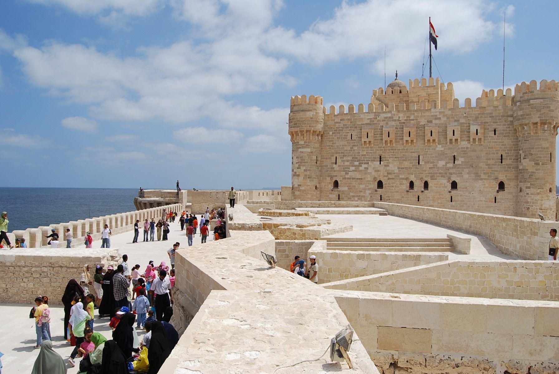
Alexandria oder Alexandrien (altgriechisch Ἀλεξάνδρεια Alexándreia, nach Alexander dem Großen; arabisch الإسكندرية al-Iskandariyya; koptisch: Ⲣⲁⲕⲟϯ Rakoti bzw. ⲁⲗⲉⲝⲁⲛⲇⲣⲓⲁ Aleksandria) ist mit über fünf Millionen Einwohnern (Stand 2023) und einer Ausdehnung von 32 Kilometern entlang der Mittelmeerküste nach Kairo die zweitgrößte Stadt Ägyptens und die insgesamt größte ägyptische Stadt mit direktem Zugang zum Mittelmeer. Sie besitzt den größten Seehafen des Landes, an dem etwa 80 % des ägyptischen Außenhandels abgewickelt werden. Als bedeutender Industriestandort wird sie über Pipelines mit Erdöl und Erdgas aus Suez versorgt.
Alexandria wurde 331 v. Chr. vom Makedonen Alexander dem Großen an der Stelle der altägyptischen Siedlung Rhakotis gegründet und unter Ptolemaios II. zwischen 285 und 247 v. Chr. fertiggestellt. Die Stadt, Residenz der Ptolemäer, entwickelte sich rasch zu einem der wichtigsten Zentren der hellenistischen Welt sowie später des römischen und frühbyzantinischen Ägypten. Sie war nach dem Ende der Ptolemäer Hauptstadt der römischen Provinz Aegyptus, in der Spätantike dann der Dioecesis Aegypti. Das antike Alexandria war vor allem für seinen Leuchtturm (Pharos), eines der sieben Weltwunder der Antike, und für seine Große Bibliothek bekannt.
Nach der Islamischen Eroberung Ägyptens 641 n. Chr. und mit der Gründung von Kairo verlor die Stadt ihre Bedeutung. Anfang des 19. Jahrhunderts zu einem vom Hinterland abgeschnittenen Fischerdorf herabgesunken, gelang Alexandria dank dem Bau des Mahmudiyakanals und dem Aufblühen des lukrativen ägyptischen Baumwollhandels der Wieder-Aufstieg zu einem wichtigen internationalen Handelszentrum.
Im Hafen von Alexandria finden seit 1994 unterwasserarchäologische Untersuchungen statt, durch die neue Erkenntnisse zur Vorgängersiedlung Rhakotis und zur ptolemäischen Epoche gewonnen werden konnten.
亚历山大[1][2](阿拉伯语:الإسكندرية,罗马化:al-Iskandarīyah,发音:[al.ʔiskanˈdarijja];埃及阿拉伯语:اسكندرية,罗马化:Eskenderiyya,发音:[eskendeˈɾejjæ];希腊语:Ἀλεξάνδρεια,罗马化:Alexándreia;英语:Alexandria),又译亚历山太和亚历山大里亚,汉时称为乌迟散[3], 埃及第二大城市、亚历山大省省会,也是地中海沿岸最大城市,阿拉伯世界第四大城市及非洲第九大城市。其地理位置为北纬31°12',东经29°15',离开罗西北208千米。尼罗河多支的、现已干枯的入海口位于亚历山大东19千米处,古城克诺珀斯的遗迹就在那里。今天亚历山大有约334万居民。
亚历山大是按其奠基人亚历山大大帝命名的,它是托勒密王朝的首都,很快就成为古希腊文化中最大的城市。在西方古代史中其规模和财富仅次于罗马。虽然埃及的伊斯兰教统治者在奠定了开罗为埃及的新首都后亚历山大的地位不断下降。但在十九世纪末期,亚历山大跃升为世界主要的船运及交易中心之一,蓬勃的棉花业与连接红海和地中海地区的优越地理位置带给这个城市丰厚的利润。

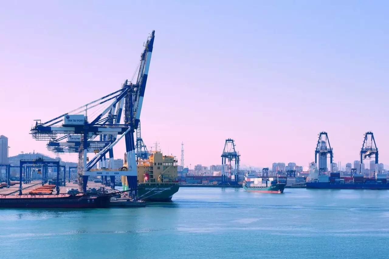
烟台港(Port of Yantai,37,CN,港口五字码:CNYAT)位于山东半岛芝罘湾,建于1861年,与市区相连,相成屏障,隔海与辽东半岛相望,与日本、韩国相对,于国际经济圈的核心地带。
烟台港是我国沿海主要港口,是国家正在建设的同江至三亚沿海南北大信道的重要结点,在全国综合运输网中居于重要地位。 烟台港历史悠久,早在 1861 年即被辟为通商口岸。新中国成立后,烟台港进行了多次扩建,特别是 1973 年以来,根据周总理“三年改变港口面貌”的指示精神,烟台港进行了较大规模扩建。随着改革开放和国民经济的发展,国家日益重视发展烟台港,烟台港建设工程被列为国家重点项目。 烟台为胶东地区的交通枢纽。烟台港带腹地内的客货交通便利,境内铁路经蓝(村)—烟(台)线接胶济线可连接全国铁路网。公路四通八达,烟潍公路烟青一级公路及在扩建的烟威一级公路,可与全国各地连网。水上运输有与国内各港口通航的沿海航线及通往省内近海航线,其中烟台至大连烟台至天津新港两条航线,其中烟台至大连的客运航线是国内最繁忙客运量最大的海运航线之一。近年又相继进行了新客运站三里桥汽车轮渡码头建设,适应了国家南北大信道运输的需求。 烟台港对外已与世界 70 多个国家和地区的 100 多个港口直接通航,每年有 800 多艘外籍船舶进出港口。烟台港国际班轮运输业务发展迅速,现已开通近 20 条适箱货物; 1996 年开通了烟台至韩国釜山群山两条客货班轮航线,中韩国际客运量和集装箱运量迅速增长。 烟台港具有广阔的发展前景。为适应烟台市建设现代化国际性港口城市战略目标的需要,正在大力加快港口建设和发展步伐。目前,烟台港总体布局规划已经国家正式批准实施,总布局分为客货区、集装箱区、散货区和远景发展区。至 2020 年,烟台港将拥有泊位 58 个,其中深水泊位 43 个,年货物吞吐量将达到 4500 万以上。
港区分布
烟台港由芝罘湾港区、西港区、龙口港区、蓬莱港区四大港区组成。
- 芝罘湾港区 承担能源进口、矿石分拨、集装箱中转。芝罘湾港区是烟台港现有的核心港区,以集装箱、客货滚装运输和矿石、煤炭、粮食、化肥、钢材等散杂货作业为主,共有泊位48个,万吨以上深水泊位25个,最大水深—20米,码头岸线长度8300米。芝罘湾港区与烟台出口加工区A区一墙之隔。针对烟台出口加工区成为全国首批拓展保税物流功能试点区的发展机遇,烟台港正与烟台出口加工区、烟台海关一起加快区港一体化建设,实施芝罘湾港区与烟台出口加工区A区的联动发展,在积极拓展国际中转、国际采购、分拨配送和国际转口贸易等功能业务的基础上,最终将芝罘湾港区发展成为现代化的自由贸易港区。
- 西港区 已建成3个3—10万吨级的液化油品码头和216万立方米的储罐设施;2015年底,将力争建成投产4个10万吨级油品码头和30万吨级原油码头。其中,西港区大型矿石码头已于2013年8月试投产运营。承担煤炭下水、化肥出口、对非进出口业务。 西港区地处烟台开发区大季家东北海域,规划港区水域面积约500平方公里,陆域面积约50平方公里(其中港口作业区面积24平方公里,临港工业区26平方公里),码头岸线总长19000米,码头前沿最大水深—28米。主要建设集装箱、液体化工、大宗散货、通用散杂、原油、LNG液化天然气等6个功能区,将建成5至30万吨级泊位65个,最终实现港口吞吐能力2亿吨和1500万标准箱,定位于以矿石、油品、煤炭、铝矾土等大宗散货和集装箱为主的综合性、专业化港区。 2015年,国家发改委和交通运输部联合发布《城镇化地区综合交通网规划》(以下简称《规划》),明确了京津冀、长江三角洲、珠江三角洲、山东半岛等21个城镇化地区的水路、铁路、公路和枢纽建设的重点工程规划,烟台港西港区名列其中。
- 龙口港区 2014年完成煤炭吞吐量1426.6万吨。龙口港区地处渤海南岸、胶东半岛西北部,与辽东半岛隔海相望,是政府规划建设的烟台市三大核心港区和两个亿吨港区之一、中国沿海最大的对非出口贸易口岸、国内铝土矿进口第一港,我国首批对台直航港口,国家拟设的北煤外运装船港。 龙口港现有码头岸线6200余米,生产泊位27个,其中10万吨级5个,5万吨级5个,万吨级7个,年核定通过能力4000万吨。主航道水深-15.5米,底宽200米,10万吨级船舶可正常进出港。港区库场面积140万平方米,公用型保税仓库面积13.8万平方米,石油化工仓储能力96万立方米,散粮罐存储能力10万吨。港口机械设备齐全,共计800余台(套),最大荷重80吨。
- 蓬莱港区 位于蓬莱市,于1995年12月正式验收投产。以通用散货和客货滚装作业为主,拥有生产泊位7个,万吨级以上泊位2个,码头岸线长度1400米。
港口经济
烟台港腹地经济发达,尤其是外向型经济发展迅速,公路、铁路运输便利,港口疏运条件优越。烟台港对外已与世界100多个国家和地区的150多个港口直接通航。近年,烟台港集装箱运输业务发展迅速,现已开通10余条国际集装箱班轮航线,可承接、中转世界各地适箱货物,尤其是中韩国际旅客运量和集装箱运量增长迅速,已开辟内贸航线18条。烟台至大连旅客运输、汽车轮渡是国内沿海最繁忙的航线之一。近年又相继进行了新客运站、三里桥汽车轮渡码头建设,适应了国家南北大通道运输的需求。 2005年,烟台港加快了芝罘湾内港口整合进度,已完成了烟台国际海运公司港务公司和山东渤海轮渡烟台客运公司的接管工作,分别于2005年底和2006年5月完成了蓬莱港和龙口港的重组整合。2005年,烟台港集团(不含龙口港)完成货物吞吐量4506万吨,较上年增长47.7%;完成集装箱吞吐量60.2万标箱,较上年增长106.7%;完成旅客运量365万人次,较上年增长21.6%。货物吞吐量、集装箱运量与旅客运量均创烟台港历史最好成绩。龙口港区在2004年实现港口吞吐量超千万吨历史性突破的基础上,2005年又跨上了1600万吨的新台阶,从2000年至2005年五年间平均增幅达到23.5%。2007年,烟台港货物吞吐量突破亿吨,成为沿海第11个亿吨港口。
港口业务
集装箱:集装箱业务由烟台港集装箱公司、烟台东龙国际集装箱码头有限公司、烟台环球码头有限公司(简称DPW)和龙口港海盛集装箱四个港埠公司共同经营,分布在四个集装箱作业区,共拥有9个专业化泊位,泊位岸线总长2000米,码头前沿最大水深—14米,配有集装箱岸桥18台,轮胎式龙门起重机27台,轨道式龙门起重机6台,堆场面积约100万平方米,各类专业配套设施齐全,能停靠装卸当今世界上先进的第六代集装箱船,年设计通过能力240万标准箱。 烟台港与中海、中远、南青、大连集发、中韩轮渡、烟台海运等国内外知名的20余家集装箱船公司合作开展集装箱运输业务,并与中海集团、南青公司建立了战略合作关系。已开通至丹东、大连、营口、锦州、秦皇岛、京唐、天津、上海、温州、泉州、深圳、广州黄埔等港口的内贸航线18条,航班月均183班;开通至日本、韩国、新加坡和美国等国家的外贸航线13条,航班月均98班;开通至大连、青岛、上海的外贸内支线3条,航班月均17班。 客货滚装:客货滚装运输业务由烟台港客运总公司和烟台港集团蓬莱港有限公司经营。烟台港客运总公司是烟台港所属一级单位,是山东省规模最大的专业化水上客货滚装企业,主要运营烟台至大连等国内航线和烟台至韩国仁川等国际航线。烟台港集团蓬莱港有限公司主要运营蓬莱至大连航线。 烟台港客货滚装业务共拥有客运站三座,码头泊位13个,码头岸线长1892米;港口客货滚装配套设施齐全,服务功能完善,年进出口旅客400多万人次,汽车滚装运输量达40多万辆。已开通(蓬莱)至大连航线2条,有7艘大型豪华客货滚装船、3艘普通客货滚装船往返运行,航班月均280班;烟台至韩国仁川的客箱航线1条,航班月均12班。 散杂货综合业务:散杂货业务由烟台港联合港埠公司和龙口港海联港埠公司经营,主要业务包括金属矿石、铝矾土、煤炭、粮食、化肥、钢铁、石油、液体化工、木材、石材等货种的接卸、储存、加工、保税和中转。烟台港散杂货作业区码头岸线近10000米,拥有金属矿石、煤炭、粮食、化肥、木材等专用泊位和通用泊位共计45个,泊位最大水深—20米,10—15万吨级大型船舶可直接靠港作业。烟台港已成为中国北方重要的金属矿石卸船港,北方煤炭装船港,并形成了区域性的粮食、化肥分拨中心和木材交易中心,今后还将逐步发展成为液体化工产品分拨基地和石油中转储备基地。
交通设施
铁路
- 德龙烟铁路(德大铁路、大莱龙铁路、龙烟铁路(建设中)),连接烟台港口的芝罘湾港区、龙口港区、西港区、蓬莱港区、莱州港区。
烟台港正参与构建由中韩铁路轮渡—德龙烟铁路—石太铁路—太中银铁路—兰新铁路所构成的跨境欧亚大陆桥建设。
航空
烟台蓬莱国际机场,距西港区仅为8公里
管道
烟台港与中海油合资建设的西港区至淄博540公里长输管道,沿途经六市,15个县级行政区,设计年输送1500万吨燃料油,兼顾远期年输送2000万吨原油能力,目前主体工程基本完工,将于2015年内投入运营。
 Vacation and Travel
