
漢德百科全書 | 汉德百科全书
 欧洲流行歌曲大赛
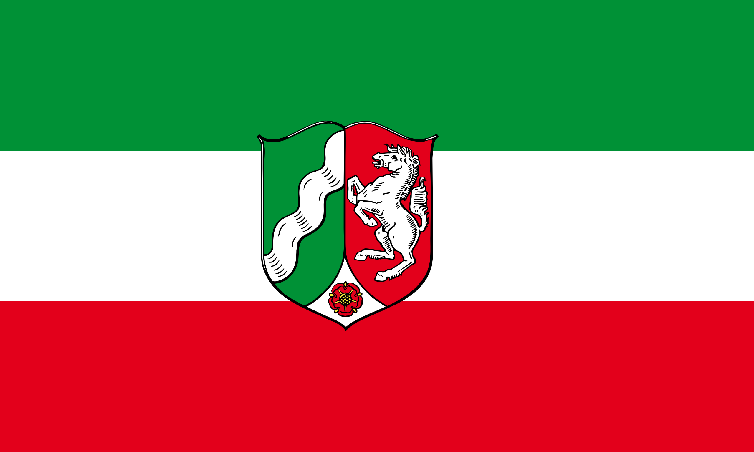 北莱茵-威斯特法伦州
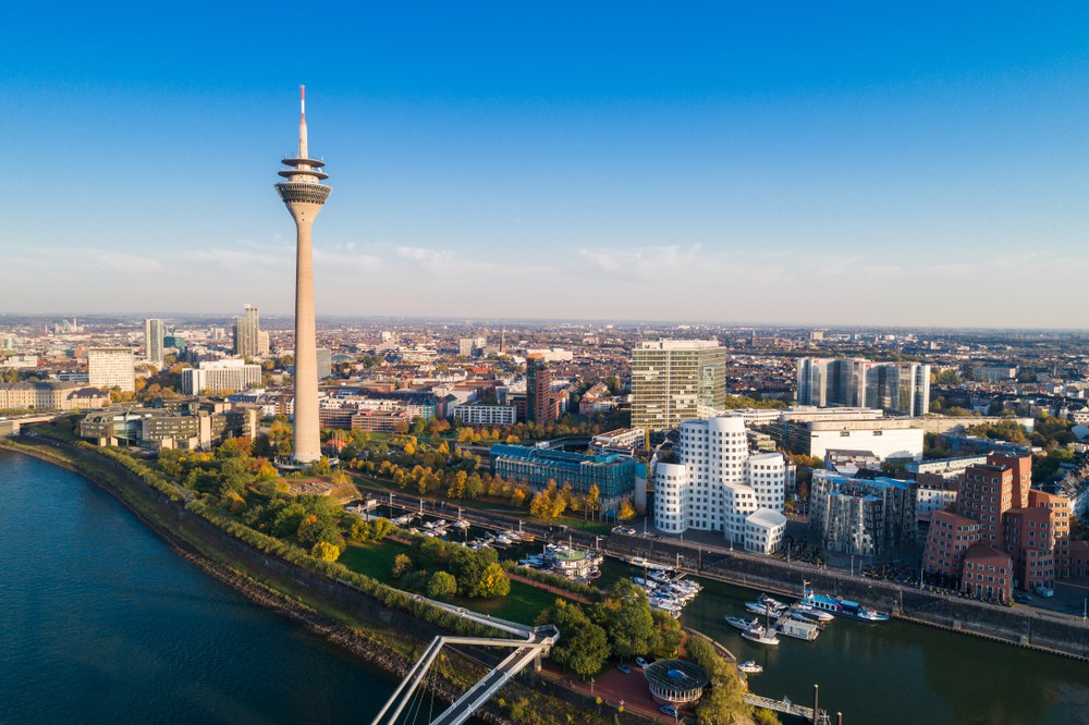
 Düsseldorf?/i ist die Landeshauptstadt Nordrhein-Westfalens und der Behördensitz des Regierungsbezirks Düsseldorf. Die kreisfreie Stadt am Rhein ist mit 617.280 Einwohnern nach Köln die zweitgrößte Stadt des Landes.[3] In Deutschland ist Düsseldorf nach Einwohnern die siebtgrößte Stadt. Düsseldorf ist Teil der Metropolregion Rhein-Ruhr mit rund zehn Millionen Einwohnern und der Metropolregion Rheinland mit 8,6 Millionen Einwohnern. Die Stadt liegt im Kern des zentralen europäischen Wirtschaftsraumes.
Im Jahr 1288 erhielt der Ort an der Mündung des Flüsschens Düssel in den Rhein das Stadtrecht. Vom Ende des 14. Jahrhunderts bis zum Beginn des 19. Jahrhunderts war die Stadt Regierungssitz von Ländern des Heiligen Römischen Reichs und des Rheinbundes: des Herzogtums Berg, der Herzogtümer Jülich-Berg und Jülich-Kleve-Berg sowie des Großherzogtums Berg, von 1690 bis 1716 auch Residenz des Pfalzgrafen und Kurfürsten Johann Wilhelm von der Pfalz. Vom 19. bis ins 20. Jahrhundert war sie Parlamentssitz der Rheinprovinz des Königreichs Preußen. Im Kaiserreich entwickelte sich Düsseldorf im Zuge der Hochindustrialisierung in Deutschland zum „Schreibtisch des Ruhrgebiets“ und wurde mit dem Überschreiten der Marke von 100.000 Einwohnern im Jahr 1882 zur Großstadt.
Die Rheinmetropole gehört zu den fünf wichtigsten, international stark verflochtenen Wirtschaftszentren Deutschlands.[4][5][6][7] Düsseldorf ist eine Messestadt und Sitz vieler börsennotierter Unternehmen, darunter der im DAX notierte Konzern Henkel. Zudem ist sie der umsatzstärkste deutsche Standort für Wirtschaftsprüfung, Unternehmens- und Rechtsberatung,[8][9] Werbung[10] und Kleidermode[11] sowie ein wichtiger Banken- und Börsenplatz.[12][13] Auch im Kunsthandel Deutschlands ist sie führend.[14]
Düsseldorf besitzt mehrere Rheinhäfen. Sein Flughafen Düsseldorf Airport ist das interkontinentale Drehkreuz Nordrhein-Westfalens. Die Stadt ist des Weiteren Sitz von 22 Hochschulen, darunter die renommierte Kunstakademie Düsseldorf und die Heinrich-Heine-Universität.[15] Überregionale Bekanntheit genießt Düsseldorf außerdem durch seine Altstadt („längste Theke der Welt“), seinen Einkaufsboulevard Königsallee („Kö“), seinen Düsseldorfer Karneval, den Fußballverein Fortuna Düsseldorf und den Eishockeyverein Düsseldorfer EG. Weitere Anziehungspunkte sind zahlreiche Museen und Galerien sowie die Rheinuferpromenade und der moderne Medienhafen. Das Stadtbild wird auch durch zahlreiche Hochhäuser und Kirchtürme, den 240 Meter hohen Rheinturm, viele Baudenkmäler und sieben Rheinbrücken geprägt. Bemerkenswert ist die große Anzahl ostasiatischer Einwohner, darunter die japanische Gemeinde, welche die größte japanische Gemeinde Deutschlands bildet.[16] In einem Vergleich der Lebensqualität von 231 Großstädten in der Welt nimmt Düsseldorf den sechsten Platz ein.[17][18][19][20]
杜塞尔多夫 —莱茵河畔的都市
一个城市 — 两条河流
因 杜塞尔河 (Düssel) 而得名, 因莱茵河而获得重要性。位于美丽的杜塞尔河与莱茵河汇流处的杜塞尔多夫市, 从前是个渔村, 其动荡的历史可以追溯到800多年前。历代伯爵和选帝侯们都在这座大都市中留下了至今可见的痕迹。歌德的杜塞尔多夫之行见于其名著《诗与真》; 而“小巴黎”这一别名则得自于拿破仑; 杜塞尔多夫是海因里希·海涅的出生地, 他曾赞誉这座城市“非常美”。
如今
杜塞尔多夫国际机场是德国第三大机场。从这里出发, 77家航空公司的航班可飞抵世界各地的180个目的地。从欧洲各个大都市乘飞机到杜塞尔多夫, 只需一个小时的时间。
杜塞尔多夫展会城每年为40家国际展会提供展览场地 —其中23家为业界主导型国际会。
杜塞尔多夫是莱茵乐天精神和世界公民魅力的成功组合— 拥有众多值得观赏和值得体验的大型活动。
杜塞尔多夫 —一座城市, 邀请人们去发现和体验! (Quelle: http://www.eurochinacom.eu/cn/culture-region/europe/germany/duesseldorf/)
杜塞尔多夫(德语:Düsseldorf),是德国北莱茵-威斯特法伦州首府,位于莱茵河畔。杜塞尔多夫市区人口约58万人,是德国广告、服装和通讯业的重要城市[1][2][3]。杜塞尔多夫也是德国最大的海外日本人聚居地,市内有许多日资公司设立。杜塞尔多夫也是19世纪德国诗人海因里希·海涅的出生地。杜塞尔多夫位于莱茵-鲁尔都会区(Metropolregion Rhein-Ruhr)核心地带,该都会区人口超过1,100万人[4]。杜塞尔多夫位于蓝香蕉范围内,是5家财富世界500强公司与几间德国DAX指数公司总部的所在地。
著名的美术学院杜塞尔多夫艺术学院(Kunstakademie Düsseldorf)设立在此,其电子及实验音乐影响广泛。因莱茵河流经杜塞尔多夫,所以杜塞尔多夫是莱茵河狂欢节活动据点。每年7月有超过450万人参观莱茵河狂欢节[5]。
杜塞尔多夫 (德语:Düsseldorf或,英语:Duesseldorf),人口57万,位于莱茵河畔。杜塞紧邻世界著名的鲁尔区,是欧洲人口最稠密、经济最发达地区北莱茵-威斯特法伦州的首府,是德国广告,服装,展览业和通讯业的重要城市,欧洲物流中心城市。
市内有十三至十八世纪古迹、艺术学院、著名陶器博物馆等。杜塞尔多夫还是19世纪德国著名诗人海因里希·海涅的出生地。杜塞尔多夫最早的文字记载可回溯于1135年。1186年,杜塞尔多夫于被纳入伯格(Berg)的管辖地(伯格是中世纪时代在北莱茵-威斯特法伦州的一个领地)。在1280年,伯格的行政署被迁到此处。过后,杜塞尔多
夫在1288年8月14日被赐城市地位。1380年,杜塞尔多夫成为伯格领地的区域首府。
デュッセルドルフ(Düsseldorf, ドイツ語発音: [ˈdʏsl̩ˌdɔɐ̯f] (![]() 音声ファイル))は、ドイツ連邦共和国の都市でノルトライン=ヴェストファーレン州の州都[2]。ライン川河畔に位置し、ライン・ルール大都市圏地域の中心でルール工業地帯のすぐ南西部にある。人口は約62万人。金融やファッション、世界的な見本市の中心都市の一つである[3][4][5]。また西ヨーロッパの中でもブルーバナナと呼ばれる、経済的にも人口的にもとくに発展した地域内に位置し、市内にはフォーチュン・グローバル500に含まれる5社や、いくつかのDAXに含まれている企業が本社を置いている。日本企業の進出も盛んで、デュッセルドルフ市内には約5,000人の日本人の駐在員やその家族などが居住し、日本総領事館などのあるインマーマン通りは日本人街の様相を呈している[6]。1971年にはデュッセルドルフ日本人学校も開校し、1990年前後には生徒数1000名近くにまで達した。2011年に行われたマーサー・ヒューマン・リソース・コンサルティングによる世界で最も居住に適した都市の調査では世界では5位、ドイツ国内では2位につけている[7][8]。
音声ファイル))は、ドイツ連邦共和国の都市でノルトライン=ヴェストファーレン州の州都[2]。ライン川河畔に位置し、ライン・ルール大都市圏地域の中心でルール工業地帯のすぐ南西部にある。人口は約62万人。金融やファッション、世界的な見本市の中心都市の一つである[3][4][5]。また西ヨーロッパの中でもブルーバナナと呼ばれる、経済的にも人口的にもとくに発展した地域内に位置し、市内にはフォーチュン・グローバル500に含まれる5社や、いくつかのDAXに含まれている企業が本社を置いている。日本企業の進出も盛んで、デュッセルドルフ市内には約5,000人の日本人の駐在員やその家族などが居住し、日本総領事館などのあるインマーマン通りは日本人街の様相を呈している[6]。1971年にはデュッセルドルフ日本人学校も開校し、1990年前後には生徒数1000名近くにまで達した。2011年に行われたマーサー・ヒューマン・リソース・コンサルティングによる世界で最も居住に適した都市の調査では世界では5位、ドイツ国内では2位につけている[7][8]。
デュッセルドルフは経済的な中心としてだけではなく、芸術的な分野でも知られた都市で、デュッセルドルフ芸術アカデミー(英語版)からはヨーゼフ・ボイスやアウグスト・マッケ、ゲルハルト・リヒター、ジグマー・ポルケ、アンドレアス・グルスキーといった画家や写真家などの芸術家を輩出している。電子音楽の先駆者で影響を与えたクラフトワークも、デュッセルドルフを起点としている。デュッセルドルフはカーニバルの開催都市としても知られている。また、毎年7月にはGrößte Kirmes am Rhein (en) が開催され、450万人以上の人々が市内を訪れる[9]。
Düsseldorf (/ˈdʊsəldɔːrf/, German: [ˈdʏsl̩dɔɐ̯f] ( listen); Low Franconian and Ripuarian: Düsseldörp [ˈdʏsl̩dœɐ̯p]), often Dusseldorf in English sources, is the capital and, after Cologne, second most populous city of the most populous German federal state of North Rhine-Westphalia, as well as the seventh most populous city in Germany.[2] At the confluence of the Rhine and its tributary Düssel, the city lies in the centre of both the Rhine-Ruhr and the Rhineland Metropolitan Regions with the Cologne/Bonn urban area to its south and the Ruhr to its north. The city is the largest in the German Low Franconian (closely related to Dutch) dialect area. Most of the city lies on the right bank of the Rhine (as opposed to Cologne, whose city centre lies on the river's left bank). "Dorf" meaning "village", Düsseldorf is the largest settlement with that suffix in the German-speaking area.
Mercer's 2012 Quality of Living survey ranked Düsseldorf the sixth most livable city in the world.[3][4] Düsseldorf Airport is Germany's third-busiest airport after those of Frankfurt and Munich, serving as the most important international airport for the inhabitants of the densely populated Ruhr, Germany's largest urban area. Düsseldorf is an international business and financial centre, renowned for its fashion and trade fairs,[5][6][7] and is headquarters to one Fortune Global 500 and two DAX companies. Messe Düsseldorf organises nearly one fifth of premier trade shows.[8] As second largest city of the Rhineland, Düsseldorf holds Rhenish Carnival celebrations every year in February/March, the Düsseldorf carnival celebrations being the third most popular in Germany after those held in Cologne and Mainz.[9]
There are 22 institutions of higher education in the city including the Heinrich-Heine-Universität Düsseldorf, the university of applied sciences (Hochschule Düsseldorf), the academy of arts (Kunstakademie Düsseldorf) (Joseph Beuys, Emanuel Leutze, August Macke, Gerhard Richter, Sigmar Polke, and Andreas Gursky), and the university of music (Robert-Schumann-Musikhochschule Düsseldorf). The city is also known for its pioneering influence on electronic/experimental music (Kraftwerk) and its Japanese community.
Düsseldorf ou Duesseldorf2 (aussi anciennement en français et en néerlandais : Dusseldorp3) est une ville de l'ouest de l'Allemagne. Capitale et deuxième plus grande ville (après Cologne) du Land de Rhénanie-du-Nord-Westphalie, située principalement sur la rive droite du Rhin, elle se trouve aux limites occidentales de la vaste agglomération de Rhin-Ruhr qui regroupe environ 11 300 000 habitants4. Septième plus grande ville d'Allemagne, Düsseldorf a une population de 601 074 habitants (recensement de juin 2014)5. En 2018, la qualité de vie à Düsseldorf est l'une des plus agréables au monde selon le classement Mercer6.
Düsseldorf (IPA: [ˈdʏsl̩dɔɐ̯f], pronuncia[?·info]; in basso tedesco Düsseldörp, IPA: [ˈdʏsl̩dœɐ̯p]) è una città extracircondariale della Germania, capitale del Land della Renania Settentrionale-Vestfalia. Situata sulle rive del Reno (Rhein in tedesco) è a circa 40 km a nord di Colonia e a circa 20 km a sud della Regione della Ruhr con le città Duisburg, Essen e Dortmund. La città, dopo Colonia, è la seconda del Land e la settima dell'intera Germania e conta 613 230 abitanti. Situata al centro della regione metropolitana Reno-Ruhr e al centro dell'area economica europea, Düsseldorf fa parte, dopo Francoforte sul Meno, Berlino, Amburgo e Monaco, dei cinque centri più intrecciati e più importanti per quanto riguarda l'economia, il traffico, la cultura e la politica tedesca.
La città è nota per essere un polo fieristico ed è sede di parecchie aziende quotate in borsa, fra cui la Uniper e la Henkel che appartengono anche al DAX 30, il più importante indice della Borsa di Francoforte. Il volume d'affari di Düsseldorf è il più alto della Germania negli ambiti della moda, pubblicità, revisione contabile, consulenza giurisprudenza e consulenza aziendale, e anche una sede importante per banche e la borsa. L'aeroporto di Düsseldorf è il punto nodale internazionale del Land Renania Settentrionale-Vestfalia.
La metropoli possiede due porti interni ed è la sede di alcune università, tra cui la famosa accademia d'arte e l'Università Heinrich-Heine. È nota in tutta la regione per l'elegante boulevard Königsallee, il centro storico, il carnevale e la squadra di calcio Fortuna Düsseldorf. Una moltitudine di musei, gallerie e il lungofiume attirano tanto abitanti quanto turisti. La quantità di abitanti dell'Asia orientale è notevole, tra questi c'è la grande comunità giapponese. Nelle indagini sulla qualità di vita nazionali ed internazionali continua ad avere un ottimo risultato.
Düsseldorf1 ( /ˈdʏsl̩dɔɐ̯f/ (?·i)) es una ciudad de Alemania, capital del estado federado de Renania del Norte-Westfalia. Tiene una población de 593 393 habitantes.
Limita al norte con la ciudad de Duisburgo, al este y al sur con el distrito de Mettmann, y al oeste con el distrito de Rhein-Kreis Neuss. La ciudad está atravesada por el Rin, es el núcleo de un área metropolitana y es el centro económico de Alemania Occidental. Es también conocida por se Academia de Bellas Artes de Düsseldorf, con figuras de la talla de Joseph Beuys, Emanuel Leutze, August Macke, Gerhard Richter, Sigmar Polke y Andreas Gursky. En 2012 la consultora Mercer la situó como la sexta ciudad con más calidad de vida del mundo.
Дю́ссельдорф (нем. Düsseldorf [ˈdʏsl̩ˌdɔɐ̯f] слушать, н.-нем. Düsseldörp) — город на западе Германии, в Рейнско-Рурском регионе, административный центр федеральной земли Северный Рейн-Вестфалия и резиденция земельного правительства округа Дюссельдорф. Население — 592,4 тыс. человек (2011)[6]. Первое упоминание Дюссельдорфа относится к 1135 году, статус города — с 1288 года.
Расположенный в центре Рейнско-Рурского и европейского экономического регионов, Дюссельдорф — наряду с Берлином, Франкфуртом-на-Майне, Мюнхеном и Гамбургом — входит в пятёрку крупнейших экономических, транспортных, культурных и политических центров Германии[7][8]. В нём находятся штаб-квартиры множества крупных компаний, в том числе E.ON и Henkel Group. Городской аэропорт является международным хабом. В Дюссельдорфе расположены две гавани, а также многочисленные высшие учебные заведения, в частности Дюссельдорфская академия художеств и Университет Генриха Гейне.
 重要港口
重要港口

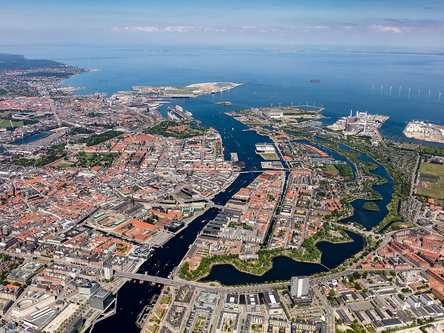
Kopenhagen (dänisch København?/i [kʰøb̥m̩ˈhɑʊ̯ˀn], in bis ins 19. Jahrhundert gültiger Rechtschreibung Kjøbenhavn) ist die Hauptstadt Dänemarks und das kulturelle und wirtschaftliche Zentrum des Landes. Die Stadt ist Sitz von Parlament (Folketing) und Regierung sowie Residenz der dänischen Königin Margrethe II.
Die dänische Hauptstadt gehört zu den bedeutendsten Metropolen Nordeuropas, ist ein beliebtes Reiseziel und Hafenstadt. Die Kommune Kopenhagen (Københavns Kommune) hat 613.288 Einwohner, die Hauptstadt im formalen Sinne (bestehend aus den Kommunen København, Frederiksberg und Gentofte) 793.501 Einwohner. Kopenhagen ist Teil der dänischen Verwaltungsregion Region Hovedstaden und der binationalen Metropolregion Öresundregion.
Im 12. Jahrhundert wurde am Øresund eine Burg errichtet, die den kleinen Handelshafen nach Schonen und Amager an der Fischersiedlung Havn („Hafen“) sichern sollte. Nicht zuletzt die günstige Lage ungefähr halbwegs zwischen dem wichtigen Bischofssitz in Roskilde und dem skandinavischen Erzbischofssitz in Lund (damals dänisch) war von entscheidender Bedeutung. Entsprechend erhielt auch die mit der Burg neu gestaltete Siedlung den Namen Køpmannæhafn („Kaufmännerhafen“). 1254 erhielt das junge Kopenhagen von Bischof Jakob Erlandsen sein erstes Stadtrecht, allerdings wurde die Stadt in den Jahren 1362 und 1368 als unliebsamer Konkurrent der Hanse zusammen mit der Burg geplündert und zerstört. Nach einem erneuten Angriff der Hanse war der Hafen 1428 eine Zeitlang von Schiffwracks blockiert.
Die Entwicklung ließ sich jedoch nicht mehr aufhalten: 1416 wurde die wiederaufgebaute Stadt Residenz des Königs, und 1443 übernahm sie von Roskilde die Hauptstadtfunktion. In der ersten Hälfte des 17. Jahrhunderts blühte Kopenhagen unter Christian IV. auf.
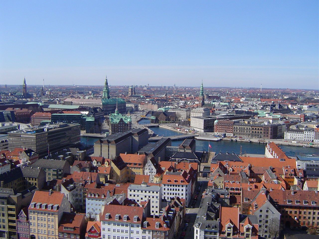
哥本哈根(丹麦语:København, 发音 帮助·信息)是丹麦的首都、最大城市及最大港口。座落于丹麦西兰岛东部,与瑞典的马尔默隔松德海峡相望。
松德海峡大桥在2000年完工后,哥本哈根与瑞典的马尔默可透过车辆和铁路往来,促成了两地人力资源的互相交流,每年利用松德海峡大桥的通勤人数不断增长。此外大桥通车后也让两座城市之间形成北欧地区最大的城市群。
在2008年,《Monocle》杂志将哥本哈根选为“最适合居住的城市”[4],并给予“最佳设计城市”的评价。哥本哈根在全球城市分类中被列为第二类世界级城市。此外哥本哈根在西欧地区获选为“设置企业总部的理想城市”第三名,仅次于巴黎和伦敦。[5]
哥本哈根城市建立之际的名称为“Kjøbmandehavn”,意为“商人的港口”。英语“Copenhagen”的名称来自于低地德语“Kopenhagen”,中文译名也由此而来。
コペンハーゲン(ドイツ語: Kopenhagen [kopənˈhaːgən])、クブンハウン(ケブンハウン)(デンマーク語: København 発音 [kʰøb̥m̩ˈhɑʊ̯ˀn] (![]() 音声ファイル)、コゥペンヘイゲン(英語: Copenhagen [ˌkoupənˈheigən])は、デンマークの首都。デンマーク最大の都市で、自治市の人口は52万人。市名はデンマーク語の"Kjøbmandehavn"(商人たちの港)に由来する。「北欧のパリ」と比喩される。
音声ファイル)、コゥペンヘイゲン(英語: Copenhagen [ˌkoupənˈheigən])は、デンマークの首都。デンマーク最大の都市で、自治市の人口は52万人。市名はデンマーク語の"Kjøbmandehavn"(商人たちの港)に由来する。「北欧のパリ」と比喩される。
Copenhagen[a] (Danish: København [købm̩ˈhɑwˀn] ( listen)) is the capital and most populous city of Denmark. The city has a population of 775,033 (as of January 2018), of whom 613,288 live in the Municipality of Copenhagen.[6][7] It forms the core of the wider Copenhagen urban area (population 1.3 million (as of January 2018) and the Copenhagen metropolitan area (population approx. 2 million). Copenhagen is situated on the eastern coast of the island of Zealand; another small portion of the city is located on Amager, and is separated from Malmö, Sweden, by the strait of Øresund. The Øresund Bridge connects the two cities by rail and road.
Originally a Viking fishing village established in the 10th century in the vicinity of what is now Gammel Strand, Copenhagen became the capital of Denmark in the early 15th century. Beginning in the 17th century it consolidated its position as a regional centre of power with its institutions, defences and armed forces. After suffering from the effects of plague and fire in the 18th century, the city underwent a period of redevelopment. This included construction of the prestigious district of Frederiksstaden and founding of such cultural institutions as the Royal Theatre and the Royal Academy of Fine Arts. After further disasters in the early 19th century when Horatio Nelson attacked the Dano-Norwegian fleet and bombarded the city, rebuilding during the Danish Golden Age brought a Neoclassical look to Copenhagen's architecture. Later, following the Second World War, the Finger Plan fostered the development of housing and businesses along the five urban railway routes stretching out from the city centre.
Since the turn of the 21st century, Copenhagen has seen strong urban and cultural development, facilitated by investment in its institutions and infrastructure. The city is the cultural, economic and governmental centre of Denmark; it is one of the major financial centres of Northern Europe with the Copenhagen Stock Exchange. Copenhagen's economy has seen rapid developments in the service sector, especially through initiatives in information technology, pharmaceuticals and clean technology. Since the completion of the Øresund Bridge, Copenhagen has become increasingly integrated with the Swedish province of Scania and its largest city, Malmö, forming the Øresund Region. With a number of bridges connecting the various districts, the cityscape is characterised by parks, promenades and waterfronts. Copenhagen's landmarks such as Tivoli Gardens, The Little Mermaid statue, the Amalienborg and Christiansborg palaces, Rosenborg Castle Gardens, Frederik's Church, and many museums, restaurants and nightclubs are significant tourist attractions. The largest lake of Denmark, Arresø, lies around 27 miles (43 kilometers) northwest of the City Hall Square.
Copenhagen is home to the University of Copenhagen, the Technical University of Denmark, Copenhagen Business School and the IT University of Copenhagen. The University of Copenhagen, founded in 1479, is the oldest university in Denmark. Copenhagen is home to the FC København and Brøndby football clubs. The annual Copenhagen Marathon was established in 1980. Copenhagen is one of the most bicycle-friendly cities in the world.
The Copenhagen Metro launched in 2002 serves central Copenhagen while the Copenhagen S-train and Lokaltog (private railway) and the Coast Line network serves and connects central Copenhagen to outlying boroughs. To relieve traffic congestion, which is partly the result of increased traffic because of the Fehmarn Belt Fixed Link road and rail construction is planned because the narrow 9-9.5 mile isthmus between Roskilde Fjord and Køge Bugt (Køge Bay) forms a traffic bottleneck. The Copenhagen-Ringsted Line will relieve traffic congestion in the corridor between Roskilde and Copenhagen.
Serving roughly two million passengers a month, Copenhagen Airport, Kastrup, is the busiest airport in the Nordic countries.
Copenhague (prononcé [kɔ.pə.naɡ]), en danois København [købm̩ˈhɑwˀn] Écouter, est la capitale et la plus grande ville du Danemark. La commune de Copenhague (Københavns Kommune) compte 569 557 habitants en 2014, et son agglomération, le Grand Copenhague, en compte 1 295 686 (janvier 2017). Le nom de Copenhague est généralement donné à l'ensemble du comté de Copenhague, qui regroupe quant à lui 1 950 430 habitants. Située sur la côte orientale de l'île de Seeland, face au détroit d'Øresund qui sépare le Danemark de la Suède voisine, Copenhague est reliée à Malmö par le pont de l’Øresund. Son nom danois, København (prononcé [kʰøb̥m̩ˈhɑʊ̯ˀn] Écouter), déformation de Købmandshavn (« le port des commerçants »), rappelle sa position stratégique sur le Kattegat, à proximité immédiate de la mer Baltique.
Fondée au Xe siècle par les Vikings, Copenhague est à l'origine un village de pêcheurs, fortifié en 1167. La ville devient la capitale du Royaume de Danemark dès le début du XVe siècle. Au cours du XVIIe siècle, sous le règne du roi Christian IV, elle devient une des plus grandes villes d'Europe du Nord, renforçant son statut de capitale. Après avoir connu les ravages de la peste et de nombreux incendies au XVIIIe siècle, Copenhague voit se construire la vieille ville actuelle, et notamment le quartier de Frederiksstaden et des institutions comme le Théâtre royal danois ou l'Académie royale des beaux-arts. En partie détruite par les troupes de l'amiral Nelson lors de la bataille de Copenhague (1801), la ville est reconstruite dans un style néoclassique durant l'Âge d'or danois. L'urbanisme de Copenhague est rénové à la suite de la Seconde Guerre mondiale par le plan Finger (en), qui organise le développement industriel et urbain autour des cinq voies ferrées partant du centre-ville (Indre By).
Copenhague est le siège du parlement national (le Folketing), du gouvernement et de la monarchie danoise ; plusieurs institutions se trouvent dans le château de Christiansborg. Elle est également le cœur industriel et financier du pays, accueillant les sièges sociaux des plus grandes entreprises danoises, comme Maersk, Novo Nordisk et la brasserie Carlsberg. Le niveau de vie y est très élevé et le PIB par habitant est parmi les plus importants au monde. Outre un dynamisme industriel dans les services et la pharmaceutique, l'économie de Copenhague est marquée par le développement des cleantechs, en lien avec l'objectif municipal de parvenir à la neutralité carbone d'ici 2025. Les transports en commun et l'usage du vélo sont très fortement développés.
Le paysage urbain de la ville est caractérisé par ses nombreux ponts, parcs et fronts de mer. Le port de Nyhavn est célèbre pour ses maisons en bois aux façades colorées. Christiania est une communauté intentionnelle autogérée, accueillant une population d'artistes, de hippies et des mouvements alternatifs. Dans le centre historique se trouvent le quartier branché de Vesterbro et le quartier latin, ainsi que le château de Rosenborg, ancienne résidence royale. À l'est, sur la côte, se trouve la citadelle du Kastellet et la statue de La Petite Sirène. Enfin, Copenhague compte deux vastes jardins aujourd'hui transformés en parc d'attractions : le Bakken et les Jardins de Tivoli.
Copenaghen (AFI: /kopeˈnaɡen/[2] ascolta[?·info]; in danese København; in italiano arcaico Copenaga[3]) è la capitale e la città più popolosa della Danimarca con 613.288 abitanti nel Comune (1.308.893 nell'area urbana al 2018). È situata sulle isole Sjælland e di Amager ed è separata dalla città svedese di Malmö dallo stretto di Øresund.
Copenhague4 (en danés: København [kʰøb̥m̩ˈhɑʊ̯ˀn] (?·i)) es la capital y la ciudad más poblada de Dinamarca, con una población urbana de 1 230 728 y una población metropolitana 1 967 727, a fecha de 1 de octubre de 2013. Está situada en la costa oriental de Selandia, a 28 km de Malmoe (Suecia), y a 164 kilómetros (102 mi) de Odense. La ciudad se extiende por partes de la isla de Amager y también contiene el enclave del municipio de Frederiksberg. Fue premiada con el título Capital Verde Europea 2014.
Originalmente un pueblo de pescadores vikingo fundado en el siglo X, Copenhague se convirtió en la capital de Dinamarca a principios del siglo XV. Durante el siglo XVII, bajo el reinado de Cristián IV, se convirtió en un importante centro regional, consolidando su posición como capital de Dinamarca y Noruega con sus instituciones, defensas, y fuerzas armadas. Tras sufrir los efectos de plagas e incendios en el siglo XVIII, la ciudad vivió una etapa de remodelación que incluyó reformas del prestigioso barrio de Frederiksstaden y de instituciones culturales como el Teatro Real y la Real Academia de Bellas Artes. Después de diferentes desastres en el siglo XIX, cuando Horatio Nelson atacó la flota danesa y bombardeó la ciudad, las reconstrucciones durante la Edad de Oro danesa trajeron un nuevo estilo neoclásico a la arquitectura kobmendense. Más tarde, tras la Segunda Guerra Mundial, el Proyecto de los Dedos fomentó la creación de viviendas y negocios a lo largo de las cinco rutas ferroviarias urbanas que se extienden hacia fuera desde el centro de la ciudad.
La historia de Copenhague se remonta a alrededor del año 800, cuando surge en torno a un pequeño pueblo de pescadores. Desde el año 1300 se convirtió en la capital de Dinamarca en detrimento de Roskilde, un estatus que la ciudad ha mantenido desde entonces. En la actualidad, Copenhague alberga alrededor del 20 % de la población de Dinamarca. Después de una crisis económica, la ciudad ha experimentado en los últimos diez años un importante progreso económico y cultural, y es ahora más fuerte tanto a nivel nacional como internacional.
La ciudad es hogar de una serie de grandes empresas y las instituciones culturales, AP Moller-Maersk, Carlsberg, Park, el Museo Nacional, la Ópera y el teatro del Rey.
Копенга́ген (дат. København [kʰøb̥ənˈhaʊ̯ˀn][3] (инф.) / [кхёбэнха́ў’н], до 1906 г. Kjøbenhavn[4], стародат. Køpmannæhafn — «гавань торговцев», лат. Hafnia) — столица и самый крупный город Дании. Располагается на островах Зеландия, Слотсхольмен и Амагер. Население исторического города составляет чуть более 600 тыс. человек, с пригородами — более 1.3 млн жителей. Часть города — самопровозглашённый Свободный город Христиания — находится на частичном самоуправлении.
Город является культурным, экономическим и правительственным центром Дании; это один из крупнейших финансовых центров Северной Европы с Копенгагенской фондовой биржей. Экономика Копенгагена имела быстрое развитие в секторе услуг, особенно посредством инициатив в информационных технологиях, фармацевтике и чистой технологии. После завершения строительства Эресуннского моста Копенгаген стал более интегрированым со шведской провинцией Скания и её крупнейшим городом Мальме, образуя Эресуннский регион.
Копенгагенский университет, основанный в 1479 году, является старейшим университетом в Дании.
 体育
体育
Göteborg?/i (schwedisch [ˌʝøtəˈbɔrj]; deutsch veraltet Gotenburg oder Gothenburg; lateinisch Gothoburgum, englisch Gothenburg, dänisch Gøteborg) ist eine Großstadt in den schwedischen Provinzen Västra Götalands län, deren Residenzstadt sie ist, und Hallands län sowie den historischen Provinzen Västergötland, Bohuslän und Halland.
Göteborg ist nach Stockholm und vor Malmö die zweitgrößte Stadt Schwedens; denselben Rang nimmt auch die Storgöteborg („Groß-Göteborg“) genannte, 13 Gemeinden umfassende Metropolregion mit 993.453 Einwohnern (Stand 30. September 2016) ein.[2] Die Stadt gliedert sich in zehn Stadtbezirke.
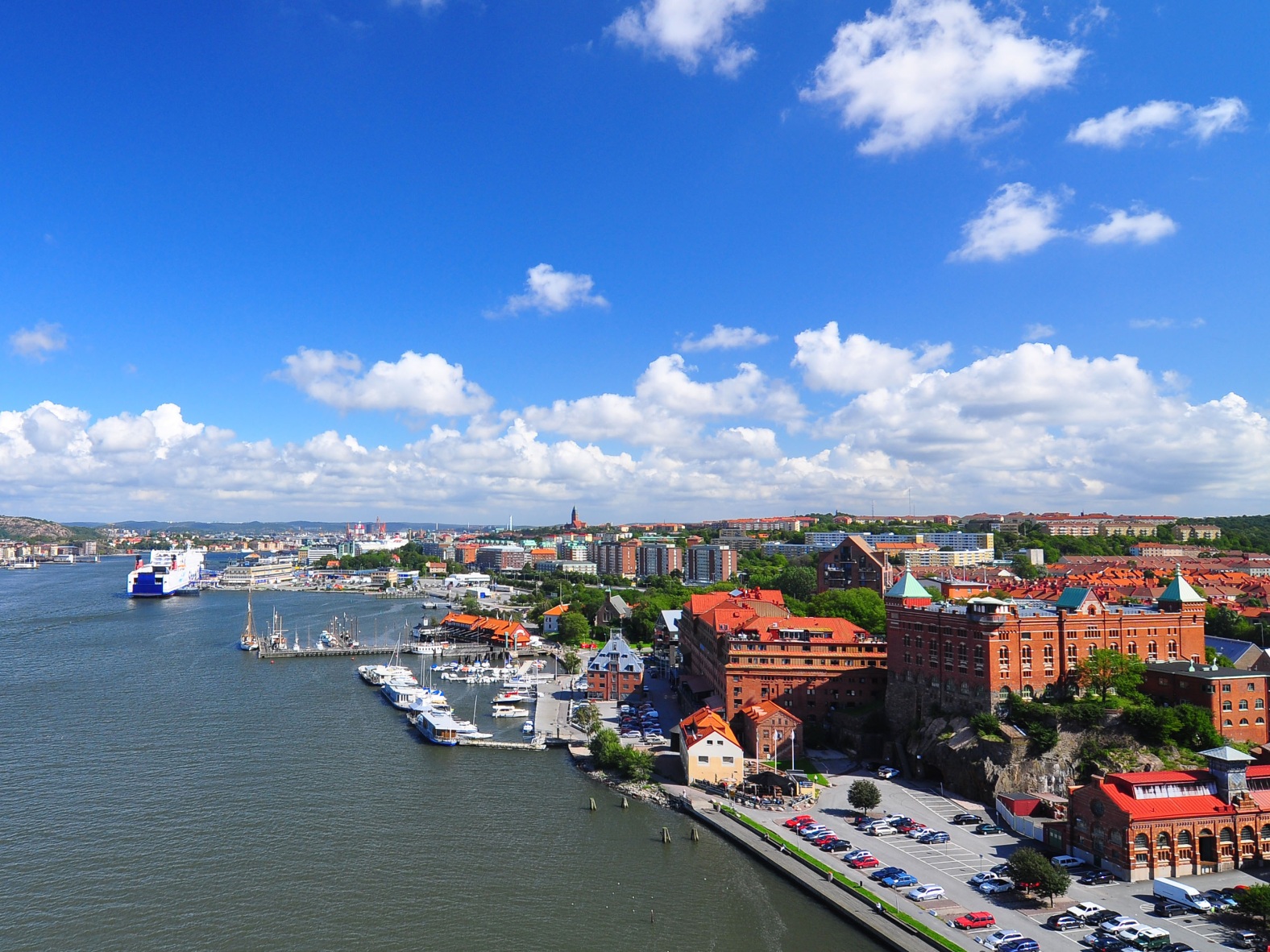
Göteborg——哥德堡的瑞典名字,瑞典第二大城市,经历了从工业海港到现代文化中心和国际运动赛场的转变。随着1994年哥德堡歌剧院的修建和部分城市博物馆的修复,哥德堡的文化景观也在进行着日新月异的提升。哥德堡最令人吃惊的变化当属餐厅和饭馆。这座城市凭借烹饪北大西洋的鱼类和贝类等当地特产,享有国际创新烹饪艺术城市的美誉。许多家餐馆都荣登过米其林指南,这令哥德堡引以为傲,当您旅行至此时,千万不要错过品尝当地美食。哥德堡是西部群岛的门户,拥有无与伦比的岛屿和姿态万千的碎礁,从市区乘船很容易到达各个岛屿。 (Quelle:http://www.sweden.cn)
哥德堡(瑞典语:Göteborg, 发音:[jœtɛˈbɔrj] ![]() 聆听)是瑞典的第二大城市,仅次于首都斯德哥尔摩。哥德堡近邻挪威,也是瑞典经济最发达的城市之一。哥德堡是瑞典享誉全球的汽车制造厂沃尔沃汽车之创厂地,而瑞典超级足球联赛中的哥登堡足球会则是一支以哥德堡为主场的球队。同时它也拥有在斯堪的纳维亚地区最多学生的哥德堡大学(Göteborgs universitet)。
聆听)是瑞典的第二大城市,仅次于首都斯德哥尔摩。哥德堡近邻挪威,也是瑞典经济最发达的城市之一。哥德堡是瑞典享誉全球的汽车制造厂沃尔沃汽车之创厂地,而瑞典超级足球联赛中的哥登堡足球会则是一支以哥德堡为主场的球队。同时它也拥有在斯堪的纳维亚地区最多学生的哥德堡大学(Göteborgs universitet)。
约塔河在哥德堡流入卡特加特海湾,将城市分成了两个部分。约塔河的入海口很适合作为港口,因此哥德堡也是北欧国家里最大的港口城市之一。
ヨーテボリ(スウェーデン語: Göteborg[ヘルプ/ファイル]、 スウェーデン語発音: [jœtɛˈbɔrj])は、ヴェストラ・イェータランド県に属するスウェーデンの港湾都市で、県庁所在地である。人口は約52万人。スウェーデンではストックホルムに次ぎ、北欧では5番目に大きい都市である。町の名前は「ゴートの都市」を意味する。日本語ではイェーテボリ、イエテボリ、エーテボリなどとも呼ばれる。
Gothenburg (/ˈɡɒθənbɜːrɡ/ ( listen);[5] abbreviated Gbg;[6][7] Swedish: Göteborg [jœtɛˈbɔrj] ( listen)) is the second-largest city in Sweden and the fifth-largest in the Nordic countries, and part of Västra Götaland County. It is situated by Kattegat, on the west coast of Sweden, and has a population of approximately 570,000 in the city center and about 1 million inhabitants in the metropolitan area.[1]
Gothenburg was founded as a heavily fortified, primarily Dutch, trading colony, by royal charter in 1621 by King Gustavus Adolphus. In addition to the generous privileges (e.g. tax relaxation) given to his Dutch allies from the then-ongoing Thirty Years' War, the king also attracted significant numbers of his German and Scottish allies to populate his only town on the western coast. At a key strategic location at the mouth of the Göta älv, where Scandinavia's largest drainage basin enters the sea, the Port of Gothenburg is now the largest port in the Nordic countries.[8]
Gothenburg is home to many students, as the city includes the University of Gothenburg and Chalmers University of Technology. Volvo was founded in Gothenburg in 1927.[9] The original parent Volvo Group and the now separate Volvo Car Corporation are still headquartered on the island of Hisingen in the city. Other key companies are SKF and Astra Zeneca.
Gothenburg is served by Göteborg Landvetter Airport 30 km (19 mi) southeast of the city center. The smaller Göteborg City Airport, 15 km (9.3 mi) from the city center, was closed to regular airline traffic in 2015.
The city hosts some of the largest annual events in Scandinavia. The Gothenburg Film Festival, held in January since 1979, is the leading Scandinavian film festival with over 155,000 visitors each year.[10] In summer, a wide variety of music festivals are held in the city, such as Way Out West and Metaltown.
Göteborg (pronuncia svedese [jœtəˈbɔrj][2] ascolta[?·info]), in italiano Gotemburgo[3], è una città della Svezia meridionale, situata nella contea di Västra Götaland e collocata nella provincia storica del Västergötland, sebbene alcuni sobborghi cittadini si estendano nella provincia di Bohuslän. Fu fondata nel 1621 dal re Gustavo II Adolfo.
Göteborg ha circa mezzo milione di abitanti, è la seconda città più popolosa della Svezia dopo Stoccolma e la quinta del Nord Europa. Se si considera l'intera area metropolitana, gli abitanti diventano più di 940.000.
Gotemburgo1 (en sueco, Göteborg [jœteˈbɔrj] (?·i)) es la segunda ciudad en importancia y tamaño de Suecia, después de la capital, Estocolmo. Ubicada en la provincia de Västra Götaland en la costa oeste del país, en la desembocadura del río Göta älv en el estrecho de Kattegat. Es la sede administrativa y arzobispal de la provincia.
Su puerto es el más grande entre los países nórdicos ya que tiene sus aguas descongeladas durante todo el año. Es el lugar de tránsito de la mayor parte de las exportaciones e importaciones de Suecia.
Grandes industrias como SKF y AB Volvo tienen sus oficinas principales en esta ciudad. Sede de dos establecimientos universitarios, tiene la población universitaria más numerosa de Escandinavia. En las últimas décadas se ha desarrollado el turismo y los eventos culturales.
Fue fundada y fortificada en 1621 por el rey Gustavo II Adolfo, después de varios intentos fallidos de fundación debido a los ataques de daneses y noruegos.
Гётеборг, Йётеборг[2] (швед. Göteborg, (Göteborg (инф.), /jœte'bɔrj/)) — город на юго-западе Швеции в лене Вестра-Гёталанд. Является вторым по величине городом Швеции после Стокгольма. Площадь города примерно — 450 км².
Расположен на берегу пролива Каттегат в устье реки Гёта-Эльв[3].

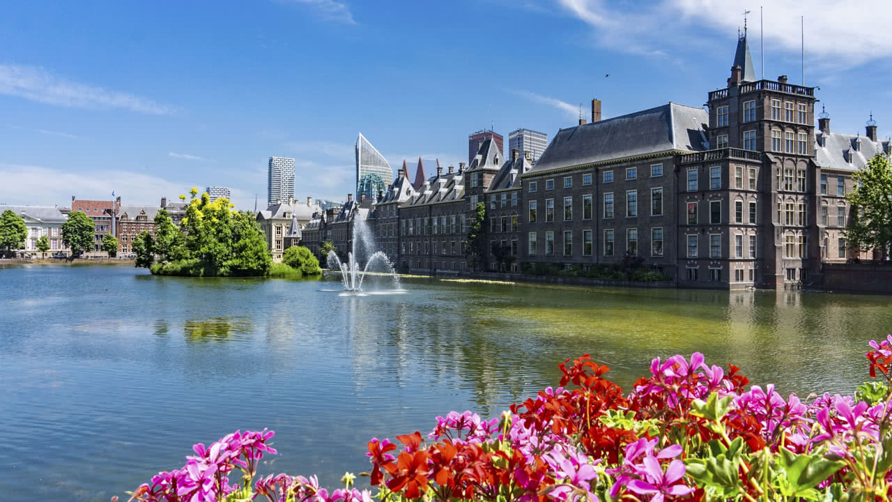
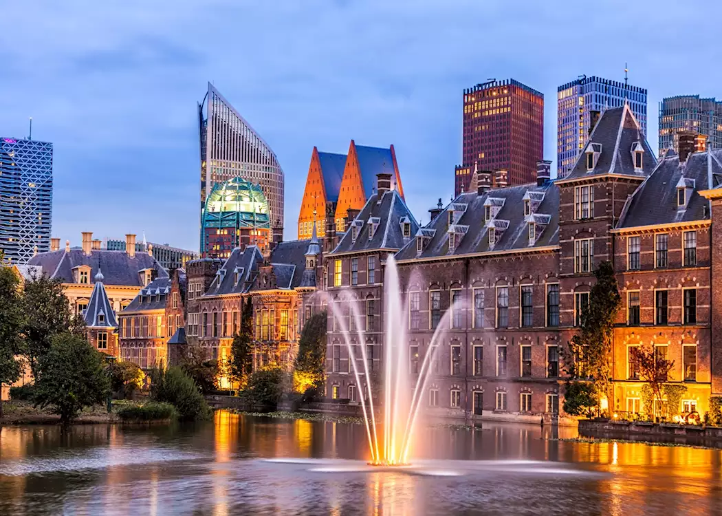
Den Haag ([dɛnˈɦaːx] ![]()
![]() , amtlich ’s-Gravenhage ([ˈsxraːvə(n)ˌɦaːɣə]
, amtlich ’s-Gravenhage ([ˈsxraːvə(n)ˌɦaːɣə] ![]()
![]() ), deutsch (veraltet) der Haag) ist der Parlaments- und Regierungssitz der Niederlande und des Königreichs der Niederlande sowie die Hauptstadt der Provinz Südholland. Seit 1831 ist die Stadt Residenz des Königshauses, Hauptstadt der Niederlande ist jedoch de jure Amsterdam.[3]
), deutsch (veraltet) der Haag) ist der Parlaments- und Regierungssitz der Niederlande und des Königreichs der Niederlande sowie die Hauptstadt der Provinz Südholland. Seit 1831 ist die Stadt Residenz des Königshauses, Hauptstadt der Niederlande ist jedoch de jure Amsterdam.[3]
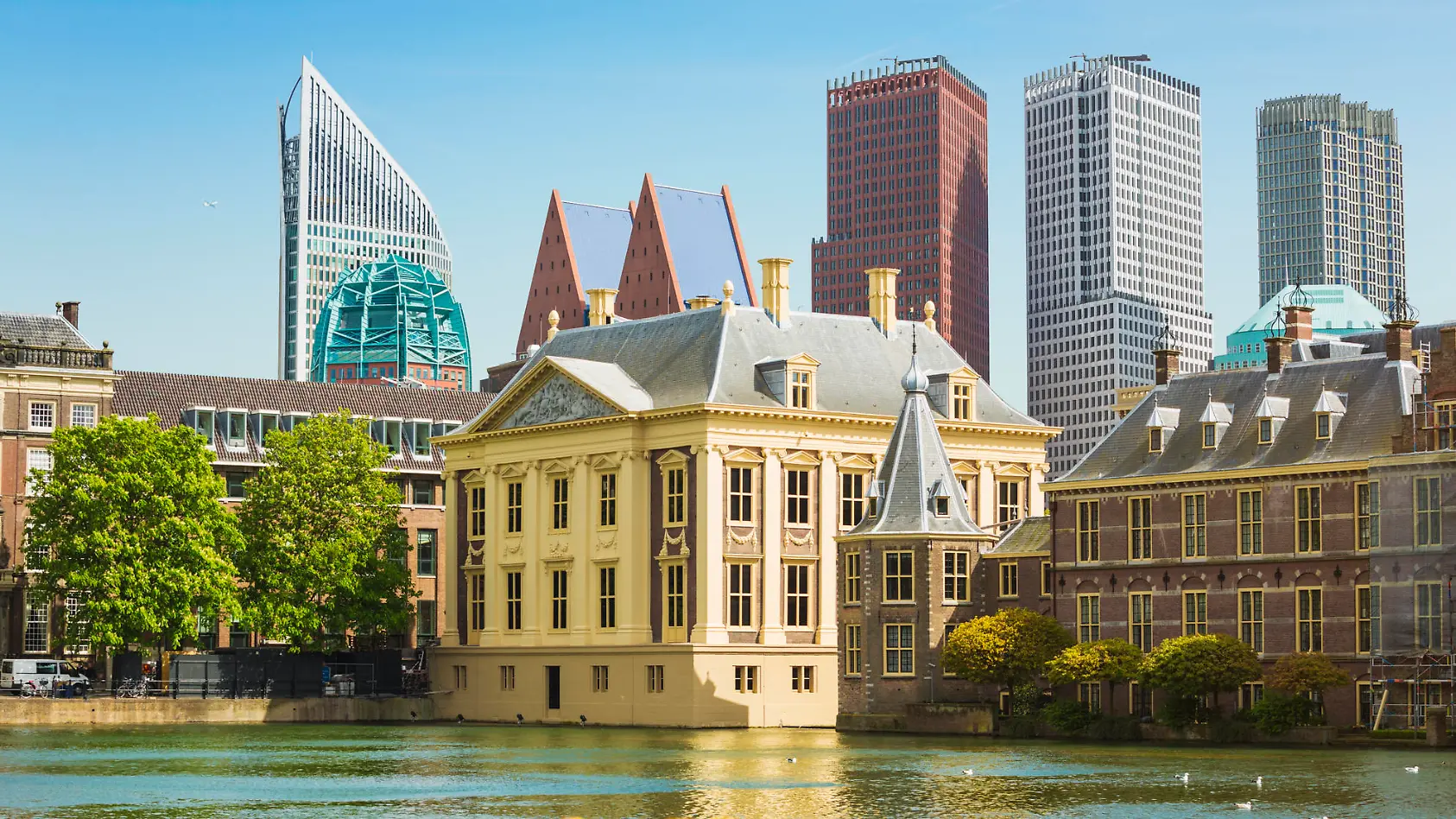
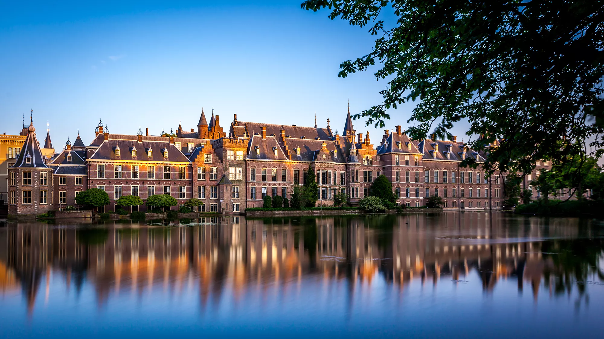
Die Gemeinde Den Haag ist mit 565.701 Einwohnern (Stand: 1. Januar 2024) auf nur 98,12 Quadratkilometern die drittgrößte Stadt der Niederlande. Der Umlandverband der Stadtregion heißt Haaglanden und zählt auf 405 Quadratkilometern mit weiteren acht Gemeinden rund eine Million Einwohner. Bekannt ist die Stadt als Sitz zahlreicher internationaler Organisationen wie des Internationalen Gerichtshofs, des Internationalen Strafgerichtshofs und der Polizeibehörde Europol.
海牙(荷兰语:Den Haag,[dɛn ˈɦaːx] (ⓘ),定冠词den不可省略),当地人又称之为斯赫拉芬哈赫[5][6](荷兰语:‘s-Gravenhage,[ˌsxraːvə(n)ˈɦaːɣə] (ⓘ))[7]:121-122,注23,24,是荷兰南荷兰省的省会,拥有人口52.6万(2017年),也是继阿姆斯特丹和鹿特丹之后的荷兰第三大城。海牙连其周边的其他八个市镇形成大海牙地区(Haaglanden),是鹿特丹–海牙都会区和兰斯塔德(Randstad)城市群的一部分。海牙市徽是鹳鸟徽。
海牙是荷兰唯一一个邻海的大城市,拥有十一公里长的海岸线,及两个海滩度假胜地:斯海弗宁恩和凯克德因(Kijkduin)。也因为位临北海带来便利的交通,海牙自十九世纪以来便是国际观光胜地。
尽管海牙不是荷兰的首都,但它是荷兰的政治中心,中央政府、议会与外国使馆皆坐落于此地,也是荷兰王室的居住地。此外,海牙也是许多国际组织的所在地,包括国际法院和国际刑事法院。
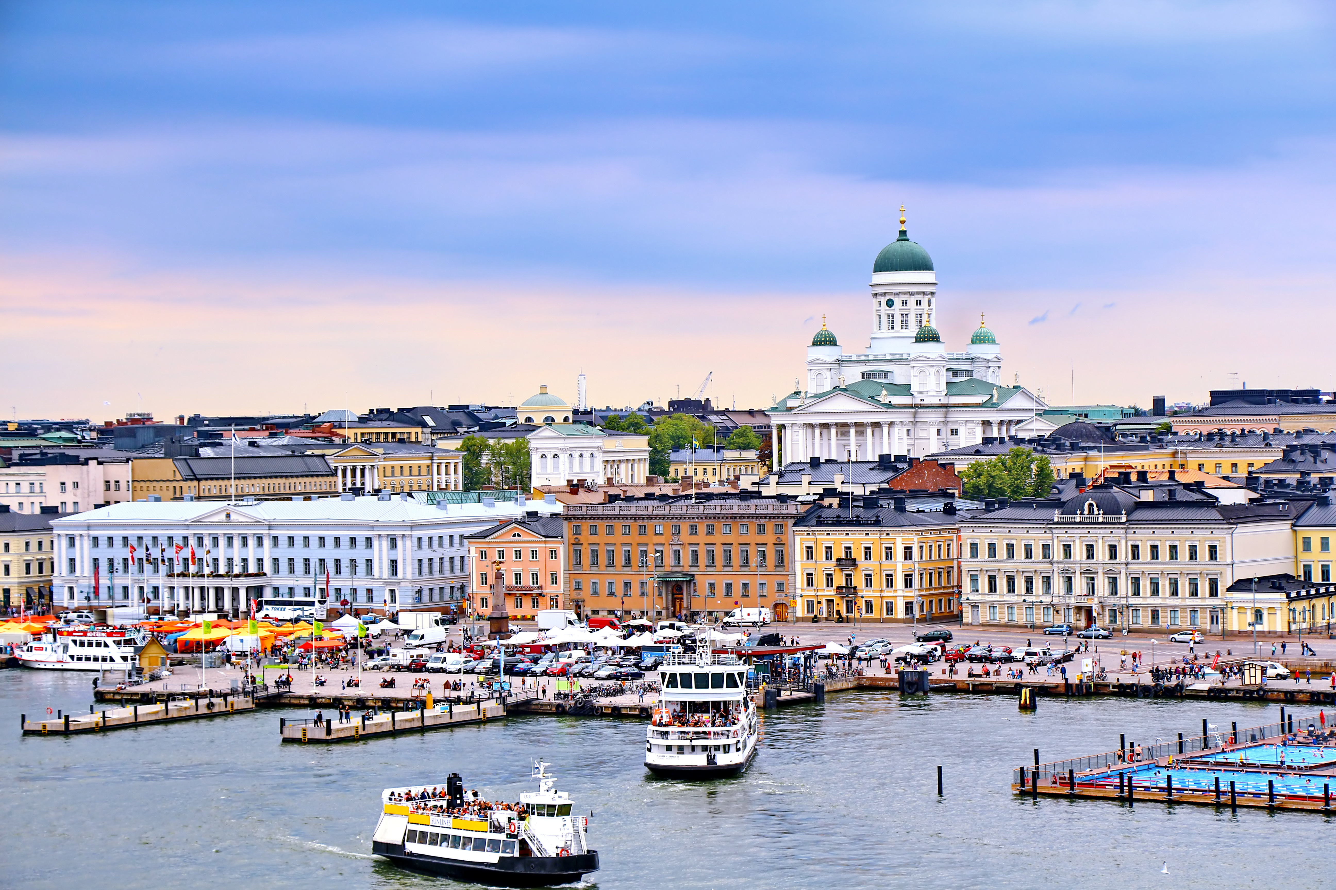
Helsinki (finnisch [ˈhɛlsiŋki], schwedisch [hɛlsɪŋˈfɔrs]) ist die Hauptstadt Finnlands. Sie liegt in der Landschaft Uusimaa im Süden des Landes an der Küste des Finnischen Meerbusens und ist die nördlichste Hauptstadt eines Mitgliedstaates der EU. Mit 648.042 Einwohnern (Stand 31. Dezember 2018) ist Helsinki mit Abstand die größte Stadt Finnlands und drittgrößte Stadt der Nordischen Länder, nach Stockholm und Oslo.
Zusammen mit den Nachbarstädten Espoo, Vantaa und Kauniainen bildet es die sogenannte Hauptstadtregion, einen Ballungsraum mit etwa 1,49 Millionen Einwohnern und damit den nördlichsten Ballungsraum der Welt mit über einer Million Einwohnern.[3] Helsinki ist das politische, wirtschaftliche, wissenschaftliche und kulturelle Zentrum Finnlands. Rund sechs Prozent der Einwohner Helsinkis sind schwedischsprachig, offiziell ist die Stadt zweisprachig.
Helsinki liegt 80 km nördlich von Tallinn, Estland, 400 km östlich von Stockholm, Schweden, und 300 km westlich von Sankt Petersburg, Russland. Es hat enge historische Verbindungen zu diesen drei Städten.
Die Stadt wurde, unter dem schwedischen Namen Helsinge fors[4], im Jahr 1550 während der Zugehörigkeit Finnlands zu Schweden gegründet, blieb aber lange unbedeutend. Kurz nachdem Finnland unter russische Herrschaft gekommen war, wurde Helsinki 1812 zur Hauptstadt des neugegründeten Großfürstentums Finnland bestimmt und löste so Turku als wichtigste Stadt des Landes ab. Der offizielle Gebrauch des finnisierten Namens Helsinki begann erst in dieser Zeit.[5]
Seit 1917 ist Helsinki Hauptstadt des unabhängigen Finnlands.
赫尔辛基(芬兰语:Helsinki [ˈhelsiŋki] ![]() 聆听;瑞典语:Helsingfors [ˌhɛlsɪŋˈfɔʂː]
聆听;瑞典语:Helsingfors [ˌhɛlsɪŋˈfɔʂː] ![]() 聆听),是芬兰的首都以及全国最大城市,芬兰语和瑞典语同为官方语言。赫尔辛基位于新地区,芬兰南端的芬兰湾岸边。在2017年底,赫尔辛基人口为643,272人[4]。所谓“大赫尔辛基”是由赫尔辛基和埃斯波、万塔、考尼艾宁四个城市一起组成的首都地区及周边市镇所组成的都会区,在2014年底的统计中有1,420,284人[5]。
聆听),是芬兰的首都以及全国最大城市,芬兰语和瑞典语同为官方语言。赫尔辛基位于新地区,芬兰南端的芬兰湾岸边。在2017年底,赫尔辛基人口为643,272人[4]。所谓“大赫尔辛基”是由赫尔辛基和埃斯波、万塔、考尼艾宁四个城市一起组成的首都地区及周边市镇所组成的都会区,在2014年底的统计中有1,420,284人[5]。
赫尔辛基在爱沙尼亚塔林北部约80公里处,距离西南的瑞典斯德哥尔摩约400公里,距离东边的俄罗斯圣彼得堡约300公里。这三座城市与赫尔辛基在历史上有着密切联系。
ヘルシンキ (フィンランド語: Helsinki,フィンランド語発音: [ˈhe̞l.siŋ.k̟i]) ![]() listen; スウェーデン語: Helsingfors,
listen; スウェーデン語: Helsingfors, ![]() listen)は、フィンランドの首都で同国最大の都市である。また、バルト海東部のフィンランド湾に面した同国南部のウーシマー県の県庁所在地である。人口は616,042人(2013年2月28日現在)[4]、都市的地域の人口は 1,176,976人(2012年12月31日現在)[5]、ヘルシンキ都市圏である大ヘルシンキの人口は約140万人でフィンランドではもっとも人口の多い自治体と都市域を形成している。
listen)は、フィンランドの首都で同国最大の都市である。また、バルト海東部のフィンランド湾に面した同国南部のウーシマー県の県庁所在地である。人口は616,042人(2013年2月28日現在)[4]、都市的地域の人口は 1,176,976人(2012年12月31日現在)[5]、ヘルシンキ都市圏である大ヘルシンキの人口は約140万人でフィンランドではもっとも人口の多い自治体と都市域を形成している。
ヘルシンキは、ロシアの旧都サンクトペテルブルク、エストニアの首都タリンと同じく、フィンランド湾に面する主要都市の一つである。ヘルシンキからの距離は、東のサンクトペテルブルクまでは300キロメートル (190 mi)、南のタリンまでは85キロメートル (53 mi)である[6]。 なお、西に400キロメートル (250 mi)の距離に位置するバルト海の対岸のスウェーデンの首都ストックホルムも加え、これらの都市とヘルシンキは歴史的に密接な関係にあった。
ヘルシンキ都市圏には核となるヘルシンキの都市的地域とエスポーやヴァンター、カウニアイネン、周辺のベッドタウンが含まれる[7]。ヘルシンキは100万人以上が住む都市圏としては最北に位置する都市圏で欧州連合加盟国の首都としては最北に位置する都市であり、フィンランドの政治や教育、金融、文化、調査センターなど様々な分野の中心都市で、ヨーロッパでも最北の大都市である。
フィンランドで事業を行う外国企業の70%はヘルシンキ地域で事業を行っており[8]、2009年に、2012年の世界デザイン首都[9]に国際インダストリアルデザイン団体協議会により選ばれ、僅差でアイントホーフェンを破っている。
エコノミスト・インテリジェンス・ユニットは2012年8月に住むのに適した都市の調査で、ヘルシンキは総合で8位にランクした[10]。2011年、モノクルマガジンの調査Liveable Cities Index 2011でヘルシンキは最も住むのに適した都市に位置している[11]。
Helsinki (/ˈhɛlsɪŋki/ HEL-sink-ee or /hɛlˈsɪŋki/ (![]() listen) hel-SINK-ee;[7][8] Finnish: [ˈhelsiŋki] (
listen) hel-SINK-ee;[7][8] Finnish: [ˈhelsiŋki] (![]() listen); Swedish: Helsingfors [hɛlsɪŋˈfɔʂː] (
listen); Swedish: Helsingfors [hɛlsɪŋˈfɔʂː] (![]() listen), Finland Swedish: [helsiŋˈforsː] (
listen), Finland Swedish: [helsiŋˈforsː] (![]() listen)) is the capital, primate and most populous city of Finland. Located on the shore of the Gulf of Finland, it is the seat of the region of Uusimaa in southern Finland, and has a population of 650,058.[9] The city's urban area has a population of 1,268,296,[10] making it by far the most populous urban area in Finland as well as the country's most important center for politics, education, finance, culture, and research; while Tampere in the Pirkanmaa region, located 179 kilometres (111 mi) to the north from Helsinki, is the second largest urban area in Finland. Helsinki is located 80 kilometres (50 mi) north of Tallinn, Estonia, 400 km (250 mi) east of Stockholm, Sweden, and 300 km (190 mi) west of Saint Petersburg, Russia. It has close historical ties with these three cities.
listen)) is the capital, primate and most populous city of Finland. Located on the shore of the Gulf of Finland, it is the seat of the region of Uusimaa in southern Finland, and has a population of 650,058.[9] The city's urban area has a population of 1,268,296,[10] making it by far the most populous urban area in Finland as well as the country's most important center for politics, education, finance, culture, and research; while Tampere in the Pirkanmaa region, located 179 kilometres (111 mi) to the north from Helsinki, is the second largest urban area in Finland. Helsinki is located 80 kilometres (50 mi) north of Tallinn, Estonia, 400 km (250 mi) east of Stockholm, Sweden, and 300 km (190 mi) west of Saint Petersburg, Russia. It has close historical ties with these three cities.
Together with the cities of Espoo, Vantaa, and Kauniainen, and surrounding commuter towns,[11] Helsinki forms the Greater Helsinki metropolitan area, which has a population of nearly 1.5 million. Often considered to be Finland's only metropolis, it is the world's northernmost metro area with over one million people as well as the northernmost capital of an EU member state. After Stockholm and Oslo, Helsinki is the third largest municipality in the Nordic countries. Finnish and Swedish are both official languages. The city is served by the international Helsinki Airport, located in the neighboring city of Vantaa, with frequent service to many destinations in Europe and Asia.
Helsinki was the World Design Capital for 2012,[12] the venue for the 1952 Summer Olympics, and the host of the 52nd Eurovision Song Contest in 2007.
Helsinki has one of the world's highest urban standards of living. In 2011, the British magazine Monocle ranked Helsinki the world's most liveable city in its liveable cities index.[13] In the Economist Intelligence Unit's 2016 liveability survey, Helsinki was ranked ninth among 140 cities.[14]
Helsinki (prononcé /ɛl.siŋ.ˈki/ ; Helsinki /ˈhɛl.siŋ.ki/ Écouter en finnois et Helsingfors /hɛl.sɪŋ.ˈfɔrs/ Écouter en suédois), est la capitale et la plus grande ville de la Finlande avec 642 045 habitants4 dans la commune et 1 456 619 dans le Grand Helsinki. Helsinki est la capitale la plus septentrionale du monde après Reykjavik, capitale de l'Islande. La ville a la plus forte population immigrée de tout le pays. Il y a plus de 130 nationalités résidant dans la ville d'Helsinki. Elle s'étale sur une presqu'île entourée d'un grand nombre d'îles et est fortement caractérisée par la présence de l'eau. Helsinki est un port marchand ouvert sur le golfe de Finlande.
Ses habitants sont appelés les Helsinkiens ; en finnois Helsinkiläiset, en suédois Helsingforsare.
Helsinki (pronuncia italiana [ˈɛlsiŋki][3]; in finlandese [ˈhelsiŋki] ; in svedese , pronuncia [hɛlsɪŋˈfɔrs]) è la capitale e la città più grande della Finlandia, con 648.650 abitanti (dato 2018)[4], situata nella regione dell'Uusimaa. La città è bilingue, le lingue ufficiali sono il finlandese e lo svedese.
Helsinki è geograficamente situata nella parte meridionale del Paese sulle rive del golfo di Finlandia, parte del mar Baltico, di fronte alla capitale dell'Estonia, Tallinn, e si estende su più isole.
L'area metropolitana di Helsinki include l'area urbana della città, Espoo, Vantaa, Kauniainen e paesi limitrofi[5]. È l'area metropolitana più a nord nel mondo, con il suo milione di abitanti è la città e capitale più a nord degli Stati membri dell'Unione europea.
A Helsinki hanno sede il parlamento, il governo, sette università e le sedi dei vescovi evangelico-luterani, cattolici e russo-ortodossi.
Nello slang di Helsinki la città è chiamata Stadi (per il vocabolo svedese stad, "città") o Hesa (forma abbraviata di "Helsinki" con il suffisso gergale -sa), lasciando intendere che chi usa il termine Stadi sia nativo della città[6]. Helsset è il termine usato dai sami del Nord per Helsinki.
Helsinki (en finlandés: Helsinki ![]() [ˈhɛlsiŋki] (?·i); en sueco: Helsingfors
[ˈhɛlsiŋki] (?·i); en sueco: Helsingfors ![]() [hɛlsɪŋˈfɔrs] (?·i)) es la capital y la ciudad más grande de Finlandia. Está situada en la costa sur del país, a la orilla del golfo de Finlandia. Helsinki forma parte de la región de Uusimaa.
[hɛlsɪŋˈfɔrs] (?·i)) es la capital y la ciudad más grande de Finlandia. Está situada en la costa sur del país, a la orilla del golfo de Finlandia. Helsinki forma parte de la región de Uusimaa.
Las influencias del Este y el Oeste se encuentran presentes en la vida diaria de Helsinki. Arquitectura, gastronomía, diseño, costumbres y hasta el argot local de las calles atestiguan un pasado bajo dominio ruso y sueco.
Situada junto al mar Báltico, la línea de costa de Helsinki se extiende unos 100 kilómetros, y acoge 300 islas frente al continente. 665 281 personas viven en la propia ciudad de Helsinki (Enero 2020)145 y el área metropolitana (municipios de Helsinki, Espoo, Vantaa y Kauniainen) tiene una población un millón de habitantes en total. Incluyendo otros municipios cercanos la población es de alrededor de 1,4 millones de personas.2 Uno de cada cuatro finlandeses vive en Helsinki.
Helsinki es el mayor centro político, educativo, financiero, cultural y de investigación, así como una de las ciudades más importantes del norte de Europa. Aproximadamente el 70 % de las empresas extranjeras que operan en Finlandia se han establecido en la región de Helsinki.6
Helsinki fue elegida Capital Mundial del Diseño para el año 2012,7 sede de los Juegos Olímpicos en 1952 y del 52º Festival de Eurovisión en 2007. Helsinki es conocida a nivel mundial por su gran diseño, el cual es bien evidente en sus calles, comercios y edificios, formando parte de la red de ciudades creativas por la UNESCO desde 2014.8
En la edición de agosto de 2012, el estudio del Economist Intelligence Unit colocó en octavo lugar a Helsinki en el ranking general de las mejores ciudades para vivir a nivel mundial.9 En 2011 la revista Monocle estableció a la ciudad de Helsinki como la mejor ciudad para vivir y desarrollarse en el mundo entero.
Хе́льсинки (фин. Helsinki, швед. Helsingfors , до 1926 года в русском языке официально использовалось шведское название Гельсингфорс[3]) — столица и крупнейший город Финляндии, административный центр провинции Уусимаа (Нюланд). Расположен на юге страны, на берегу Финского залива Балтийского моря. Население — 655 281 человека (31.1.2020)[4]. Иностранные граждане составляют около 10 % населения города.
Хельсинки вместе с городами-спутниками Вантаа (Ванда), Эспоо (Эсбy[5]) и Кауниайнен (Гранкулла) образует столичный регион с населением более миллиона человек. Население Большого Хельсинки, территория которого включает 12 коммун, превышает 1,3 миллиона человек[2]. Хельсинки является центром бизнеса, образования, культуры и науки в Финляндии. В Большом Хельсинки расположены 8 университетов и 6 технологических парков[6]. 70 % иностранных компаний, работающих в Финляндии, расположены в столичном регионе[6]. Миграция населения из провинции делает Хельсинки одним из самых быстрорастущих муниципальных районов в Европе. Главным международным авиаузлом в Финляндии является Аэропорт Хельсинки-Вантаа, расположенный в 20 километрах от центра столицы и осуществляющий прямые перелёты по всему миру. Путь от Хельсинки до Таллина занимает 1,5 часа по морю и 18 минут на вертолёте (расстояние составляет 80 км). В два других крупных города, Тампере и Турку, можно попасть за 1,5—2 часа на поезде и 1,5—2,5 часа на машине. На скоростном поезде «Аллегро» до Санкт-Петербурга можно добраться за 3,5 часа (390 км).
В 2014 году в рейтинге 25 лучших городов мира, составленном британским журналом Monocle[en], Хельсинки занял пятое место (на первом месте — Копенгаген)[7]. В 2011 году в опубликованном международной консалтинговой компанией Mercer рейтинге наиболее безопасных городов мира Хельсинки разделил 2—4 места с Цюрихом и Берном (на первом месте — Люксембург)[8][9]. В начале 2012 года газета The New York Times в ежегодно публикуемом ею списке мест нашей планеты, которые стоит посетить в наступившем году, поставила Хельсинки на второе место (на первом месте — Панама, на третьем — Мьянма)[10][11].
По опросам общественного мнения в 2012 году Хельсинки занимает четвёртое место по уровню привлекательности для проживания среди финских граждан[12].
В 2013 году по расчетам консалтингового агентства ECA International Хельсинки занял двадцатое место в рейтинге самых дорогих городов планеты (первое место — Осло)[13], а международная деловая газета Financial Times представила ряд районов финской столицы в лучшем свете как мест для вложений в недвижимость[14].
День города отмечается ежегодно 12 июня[15].
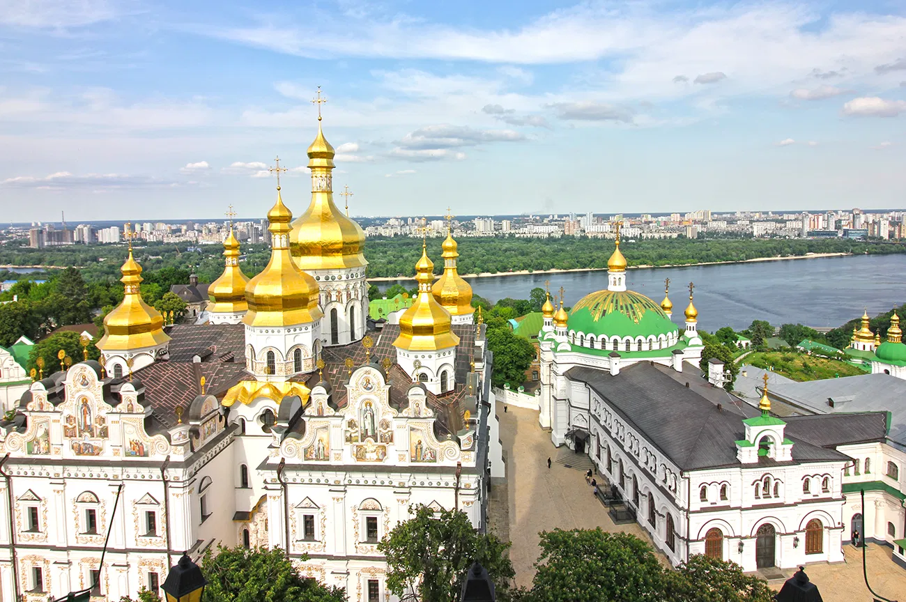
Kiew (ukrainisch Київ/Kyjiw [ˈkɪjiu̯]; russisch Киев/Kijew [ˈkʲi(ɪ̯)ɪf]) ist die Hauptstadt und größte Stadt der Ukraine sowie Verwaltungssitz des Oblast Kiew und des Rajon Kiew-Swjatoschyn. Sie liegt am bis hierhin für kleinere Seeschiffe befahrbaren Dnepr und hat etwa 2,9 Millionen Einwohner im Stadtgebiet[1], die Agglomeration umfasst mehr als vier Millionen Einwohner.
Kiew gilt als wichtiger Bildungs- und Industriestandort und bildet darüber hinaus den wichtigsten Verkehrsknotenpunkt des Landes. Aufgrund ihrer historischen Bedeutung als Mittelpunkt der Kiewer Rus trägt die Stadt oft den Beinamen Mutter aller russischen Städte. Wegen der vielen Kirchen und Klöster und seiner Bedeutung für die orthodoxe Christenheit wird Kiew seit dem Mittelalter außerdem als Jerusalem des Ostens bezeichnet. Nach Ende des Zweiten Weltkriegs erhielt Kiew die Auszeichnung einer Heldenstadt. Der am 28. August 1973 von T. M. Smirnowa am Krim-Observatorium entdeckte Asteroid (2171) Kiev wurde nach der Stadt benannt.
城市西部地势高亢,东部低平、宽阔。属温和的大陆性气候。基辅市区有数十条林荫大道以及数百个街心花园和草坪,一幢幢现代化的建筑掩映在绿树和花丛中, 基辅因而赢得了“花园城市”的美名。 基辅的历史已有1500多年。古老的属于人类文明最高的成就之一的乌克兰文化是在这里形成的。历史悠久。始建于5世纪下半叶,9~13世纪为第一个俄罗斯 国家基辅罗斯的都城和中心,有“俄国城市之母”之称。1793年并入俄国。自古为贸易要冲。19世纪末成为俄国西南部重要商业城市和甜菜制糖中心。 1934年乌克兰首都由哈尔科夫迁此。第二次世界大战中曾被德军占领。战后重建,工业基础不断扩展。
该市接近顿巴斯和第聂伯河沿岸钢铁基地, 周围是富饶的农业区,机械制造业和轻工业发达。机械制造业门类较多,大多与运输业相联系,还有机床、仪器、化工和机械等。轻工业有照相机、食品、编织品 等。化学工业和印刷出版业也很发达。是乌克兰的交通枢纽。东郊设有国际机场,河运直达黑海,市内建有地下铁道。 (Quelle:http://baike.baidu.com)
基辅(乌克兰语:Київ,转写:Kyiv [ˈkɪjiu̯] ![]() 聆听;古东斯拉夫语:Кыѥвъ;俄语:Киев,转写:Kiyev [ˈkʲiɪf])位于乌克兰中北部第聂伯河中游,是乌克兰首都、基辅州首府及第一大城市,人口达2,907,817(2016年)。[4]
聆听;古东斯拉夫语:Кыѥвъ;俄语:Киев,转写:Kiyev [ˈkʲiɪf])位于乌克兰中北部第聂伯河中游,是乌克兰首都、基辅州首府及第一大城市,人口达2,907,817(2016年)。[4]
基辅是东欧重要的工业、科学、文化及教育中心,也是许多高科技产业、高等教育机构和历史建筑的所在地,拥有广泛的基础设施和高度发达的公共交通系统,如基辅地铁。
基辅的名称来自“Kyi”,传说中这座城市的建立者之一(Kyi, Shchek, Khoryv三兄弟和姐妹Lybid)。基辅在5世纪时是一座交易所,后逐渐成为东斯拉夫文明的中心,并在10世纪至13世纪成为基辅罗斯的首都。1240年12月的拔都入侵彻底摧毁了这座城市,使基辅失去过去数个世纪所获得的政治影响力。后来强盛邻国的兴起,使得这里成为这些大国的边境重镇(立陶宛大公国、波兰立陶宛联盟、俄罗斯帝国)。
19世纪末,基辅因俄罗斯帝国的工业革命而再度兴起。基辅在经历1917年俄国革命引发的动荡时期后,自1921年起成为乌克兰苏维埃社会主义共和国的重要城市,1934年后成为首都。苏德战争期间,基辅在1941年7月7日—9月26日的基辅战役中被纳粹德国国防军占领,1943年10月被红军解放,并迅速发展成为苏联第三大城市。1991年苏联解体,乌克兰独立,基辅成为乌克兰首都。
キエフ(ウクライナ語: Київ [ˈkɪjiw] (![]() 音声ファイル) キーイウ[4]、ロシア語: Киев [ˈkʲiɪf])は、ウクライナの首都。ドニプロ川の中流に位置する。同国最大の都市で、政治・経済・社会・学術・交通の中心地である。特別自治都市。5世紀後半に建設されたポリャーネ族の集落から発展した。中世にはキエフ・ルーシの都であったが、近世にはコサックのキエフ連隊の中心となった。20世紀中にウクライナ人民共和国、ウクライナ国とウクライナ・ソビエト社会主義共和国の首都であり続けた。キエフ市内の人口はおよそ279万人であるが、キエフ首都圏の人口はおよそ400万人となっている。東ヨーロッパにおける最古の都市で、キリスト教の聖地の一つである。都内にある聖ソフィア大聖堂とキエフ洞窟大修道院は世界遺産に登録されている。
音声ファイル) キーイウ[4]、ロシア語: Киев [ˈkʲiɪf])は、ウクライナの首都。ドニプロ川の中流に位置する。同国最大の都市で、政治・経済・社会・学術・交通の中心地である。特別自治都市。5世紀後半に建設されたポリャーネ族の集落から発展した。中世にはキエフ・ルーシの都であったが、近世にはコサックのキエフ連隊の中心となった。20世紀中にウクライナ人民共和国、ウクライナ国とウクライナ・ソビエト社会主義共和国の首都であり続けた。キエフ市内の人口はおよそ279万人であるが、キエフ首都圏の人口はおよそ400万人となっている。東ヨーロッパにおける最古の都市で、キリスト教の聖地の一つである。都内にある聖ソフィア大聖堂とキエフ洞窟大修道院は世界遺産に登録されている。
Kiev (/ˈkiːɛf, -ɛv/ KEE-ef, -ev)[10] or Kyiv (Ukrainian: Київ, translit. Kyiv [ˈkɪjiu̯] (![]() listen); Russian: Киев, translit. Kiyev [ˈkʲi(j)ɪf]; Old East Slavic: Кыѥвъ, translit. Kyjev) is the capital and largest city of Ukraine, located in the north central part of the country on the Dnieper. The population in July 2015 was 2,887,974[2] (though higher estimated numbers have been cited in the press),[11] making Kiev the 7th most populous city in Europe.[12]
listen); Russian: Киев, translit. Kiyev [ˈkʲi(j)ɪf]; Old East Slavic: Кыѥвъ, translit. Kyjev) is the capital and largest city of Ukraine, located in the north central part of the country on the Dnieper. The population in July 2015 was 2,887,974[2] (though higher estimated numbers have been cited in the press),[11] making Kiev the 7th most populous city in Europe.[12]
Kiev is an important industrial, scientific, educational, and cultural centre of Eastern Europe. It is home to many high-tech industries, higher education institutions, and world-famous historical landmarks. The city has an extensive infrastructure and highly developed system of public transport, including the Kiev Metro.
The city's name is said to derive from the name of Kyi, one of its four legendary founders (see Name, below). During its history, Kiev, one of the oldest cities in Eastern Europe, passed through several stages of great prominence and relative obscurity. The city probably existed as a commercial centre as early as the 5th century. A Slavic settlement on the great trade route between Scandinavia and Constantinople, Kiev was a tributary of the Khazars,[13] until seized by the Varangians (Vikings) in the mid-9th century. Under Varangian rule, the city became a capital of the Kievan Rus', the first East Slavic state. Completely destroyed during the Mongol invasion in 1240, the city lost most of its influence for the centuries to come. It was a provincial capital of marginal importance in the outskirts of the territories controlled by its powerful neighbours; first the Grand Duchy of Lithuania, followed by Poland and Russia.[14]
The city prospered again during the Russian Empire's Industrial Revolution in the late 19th century. In 1917, after the Ukrainian National Republic declared independence from the Russian Empire, Kiev became its capital. From 1921 onwards Kiev was a city of the Ukrainian Soviet Socialist Republic, which was proclaimed by the Red Army, and, from 1934, Kiev was its capital. During World War II, the city again suffered significant damage, but quickly recovered in the post-war years, remaining the third largest city of the Soviet Union.
Following the collapse of the Soviet Union and Ukrainian independence in 1991, Kiev remained the capital of Ukraine and experienced a steady migration influx of ethnic Ukrainians from other regions of the country.[15] During the country's transformation to a market economy and electoral democracy, Kiev has continued to be Ukraine's largest and richest city. Kiev's armament-dependent industrial output fell after the Soviet collapse, adversely affecting science and technology. But new sectors of the economy such as services and finance facilitated Kiev's growth in salaries and investment, as well as providing continuous funding for the development of housing and urban infrastructure. Kiev emerged as the most pro-Western region of Ukraine where parties advocating tighter integration with the European Union dominate during elections.Kiev (en ukrainien : Київ /ˈkɪjiu̯/, Kyïv, Kyiv ; en russe : Киев, Kiev ; en polonais : Kijów /ˈkʲijuf/) est la capitale et la plus grande ville d'Ukraine. C'est aussi la capitale de l'oblast de Kiev et l'une des plus anciennes villes de Ruthénie (au sens large). Elle comptait 2 845 023 habitants en 2013.
Kiev se trouve sur la rivière Dnipro, au Nord-Ouest du pays. La date exacte de la fondation reste inconnue. Les fouilles archéologiques donnent lieu de croire que Kiev est devenu une ville à la fin de IXe siècle. Kiev a été la capitale de Ruthénie, de la principauté de Kiev, du grand-duché de Ruthénie, de la République populaire ukrainienne, de l’État ukrainien et de la République socialiste soviétique d'Ukraine. Kiev a été aussi le centre administratif du grand-duché de Ruthénie, de la voïvodie de Kiev, du gouvernement de Kiev, du district général de Kiev pendant la Seconde Guerre mondiale et de l'oblast de Kiev.
La ville est un des plus anciens centres de l'Europe de l'Est et du christianisme. La cathédrale Sainte-Sophie et la laure des Grottes de Kiev sont inscrites sur la liste du patrimoine mondial.
Kiev (in ucraino: Київ? , traslitterato Kyjiv, IPA [ˈkɨjiu̯]; in russo: Киев?, traslitterato: Kiev ) è la capitale e la maggiore città dell'Ucraina. Conta 2.906.600 abitanti.
Kiev1 (en ucraniano, Київ [Kyiv ![]() /ˈkɪjiu̯/ (?·i)]; en ruso, Киев [Kiev /ˈkʲiɪf/]; en polaco, Kijów) es la capital y mayor ciudad de Ucrania, así como del óblast de Kiev, con una población de aproximadamente 2,8 millones de habitantes.2 Kiev es un importante centro industrial, científico, educativo y cultural de Europa del Este. Es sede de muchas industrias de alta tecnología, instituciones educativas y de famosos monumentos históricos. La ciudad cuenta con una amplia infraestructura y un sistema de transporte público, incluyendo el Metro de Kiev.
/ˈkɪjiu̯/ (?·i)]; en ruso, Киев [Kiev /ˈkʲiɪf/]; en polaco, Kijów) es la capital y mayor ciudad de Ucrania, así como del óblast de Kiev, con una población de aproximadamente 2,8 millones de habitantes.2 Kiev es un importante centro industrial, científico, educativo y cultural de Europa del Este. Es sede de muchas industrias de alta tecnología, instituciones educativas y de famosos monumentos históricos. La ciudad cuenta con una amplia infraestructura y un sistema de transporte público, incluyendo el Metro de Kiev.
El nombre de la ciudad se dice que deriva del nombre de Kiy, uno de sus cuatro fundadores legendarios. Durante su historia, Kiev, una de las ciudades más antiguas de Europa del Este, pasó por varias fases de gran prominencia y una relativa oscuridad. La ciudad, probablemente, existió como un centro comercial ya en el siglo V. Un asentamiento eslavo en la gran ruta comercial entre Escandinavia y Constantinopla, Kiev era tributaria de los jázaros,3 hasta que los varegos se apoderaron de ella (vikingos) en la segunda mitad del siglo IX. Bajo el dominio varego, la ciudad se convirtió en capital del Rus de Kiev, el primer estado eslavo oriental. Completamente destruida durante la invasión de los mongoles en 1240, la ciudad perdió gran parte de su influencia en los siglos venideros. Fue una capital provincial de importancia marginal en las afueras de los territorios de diversos estados: en primer lugar del Gran Ducado de Lituania, seguido de Polonia y Rusia.4
La ciudad prosperó nuevamente durante la revolución industrial del Imperio Ruso en el siglo XIX. En 1917, después de que la República Popular Ucraniana declarase su independencia del Imperio Ruso, Kiev se convirtió en su capital. Y a partir de 1921 en adelante, Kiev era una ciudad importante de la República Socialista Soviética de Ucrania, y, a partir de 1934, su capital. Durante la Segunda Guerra Mundial, la ciudad volvió a sufrir daños significativos, pero se recuperó rápidamente en los años de la posguerra, quedando como la tercera ciudad más grande de la Unión Soviética. Tras el colapso de la Unión Soviética y la Declaración de Independencia de Ucrania de 1991, Kiev se vuelve la capital de Ucrania independiente. Desde que el ruso ha dejado de ser la lengua oficial en Ucrania, se ha incitado a usar el nombre ucraniano Kyiv.Ки́ев (др.-рус. Києвъ, Кыѥвъ, рус. дореф. Кіевъ, укр. Київ [ˈkɪjiu̯] произношение ) — столица и крупнейший город Украины. Расположен на реке Днепр, центр Киевской агломерации. Отдельная административно-территориальная единица Украины; культурный, политический, социально-экономический, транспортный, научный и религиозный центр страны. Киев — административный центр Киевской области и Киево-Святошинского района Киевской области, хотя и не входит в их состав, имея особый правовой статус. Расположен на севере центральной части Украины. Киев — седьмой по населению город Европы после Стамбула, Москвы, Лондона, Санкт-Петербурга, Берлина и Мадрида[7].
За свою историю Киев был столицей полян, Киевской Руси, Киевского княжества, Украинской Народной Республики, Украинской Народной Республики Советов, Украинской державы, Украинской Советской Социалистической Республики, а с 1991 года — независимой Украины. В нём расположены руководящие структуры ГУАМ и УНТЦ. В силу его значения как исторического центра Руси, город именуют «матерью городов русских»; в силу заслуг периода Второй мировой войны — носит высшую степень отличия «Город-герой».
Die Blumenstadt am Dnepr, San Francisco Osteuropas oder die Mutter aller russischen Städte sind nur einige Bezeichnungen für die ukrainische Hauptstadt Kiew. Die zu Unrecht als graue Plattenbaustadt bezeichnete ukrainische Metropole hat viele schöne Seiten. Nicht umsonst hat sich die UEFA dazu entschieden, das Finale der Fussball-Europameisterschaft 2012 in Kiew stattfinden zu lassen.
Kiew (ukrainisch Kyjiw) liegt im Norden der Ukraine am Fluss Dnepr und beherbergt 2.700.000 Einwohner. Ähnlich zu San Francisco ist auch Kiew von einen hügeligen Stadtbild geprägt. Geschuldet ist dies dem umliegenden Prydniprovska Hochland.
Read more about Ukraine by www.osteuropa-reisen.net
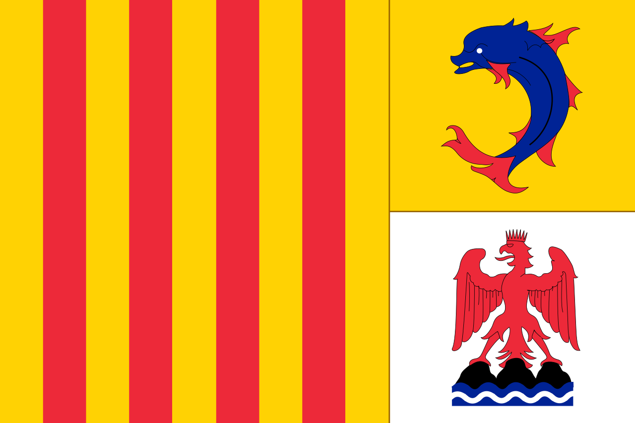 普罗旺斯-阿尔卑斯-蓝色海岸
Das Stadtviertel La Californie In diesem Stadtteil, der sich über einen sanften Hügel hinzieht, gibt es sehr viel Grün. Hier gedeiht das ganze Jahr über mediterrane Vegetation: Aloen, Mimosen, Korkeichen... Und genau diese Flora, die den Besucher an den amerikanischen Westen denken lässt, hat dem Viertel Californie seinen Namen gegeben. Von den schönen Häusern und Hotels der Belle Époque gibt es leider nur noch wenige Überreste. Trotzdem wird auch heute noch dieser Stadtteil von der hohen Gesellschaft bevorzugt. Die Villen sind luxuriös und prunkvoll, manchmal allerdings so gut in weitläufig angelegten Gärten verborgen, dass man sie nicht sofort entdeckt. Ein traumhaftes kleines Kalifornien!
Das Stadtviertel Le Cannet Geht man den langen breiten Boulevard Carnot hinauf, so gelangt man zum ruhigen, friedlichen Stadtteil Cannet. Es lohnt sich, in diesem alten Viertel einen Rundgang zu machen. Die malerische Architektur lässt den Eindruck aufkommen, man bewege sich in einem kleinen Dorf irgendwo im Hinterland. Außerdem kommt man an zahlreichen Handwerks- und Kunstgalerien, einer von Tobiasse dekorierten Kapelle sowie einer Unmenge kleiner feiner Restaurants vorbei.
(Quelle:http://de.reisen.yahoo.com/p-reisefuehrer-2220363-cannes_allgemeines-i)
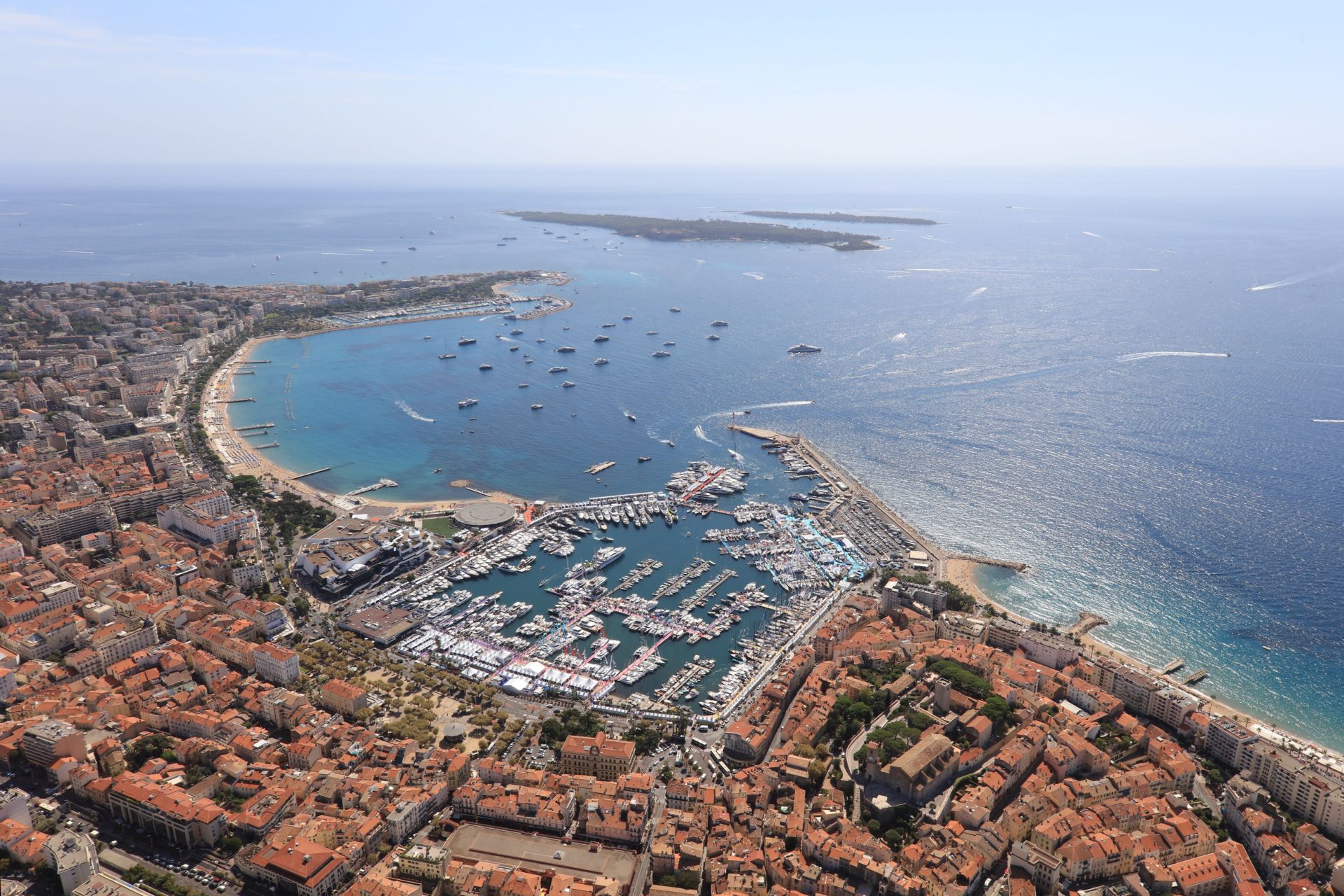
Cannes [kan] (okzitanisch Canas, von lateinisch canna ‚Schilf‘) ist eine Stadt mit 74.285 Einwohnern (Stand 1. Januar 2015) in Südfrankreich an der Côte d’Azur im Département Alpes-Maritimes. Cannes liegt am Mittelmeer. Im Hinterland liegen nordöstlich die Ausläufer der Seealpen. Westlich der Stadt erstreckt sich das Esterel-Gebirge mit der Steilküste aus rotem Porphyr.
戛纳是法国东南部城市,欧洲有名的旅游胜地和国际名流社交集会场所,因国际电影节而闻 名于世。位于尼斯西南约26千米,濒地中海,是阿尔卑斯滨海省政府省政府会。人口7.1万(1975)。这里海水蔚蓝、棕榈葱翠,气候温各,风光明媚,与 尼斯和蒙特卡洛并称为南欧三大游览中心。戛纳拥有世界上最洁白漂亮的海滩,海滨建有游泳场。是度假的好场所。棕榈树海滨大道沿海岸伸展,道旁多豪华旅馆。 戛纳国际电影节所在地。为旅游地。戛纳主要景点有:海滨大道、老城区、11世纪城堡等。
世界上著名的“戛纳电影节”,被誉 为“电影界的奥运会”。戛纳电影节一年一次,它颁发的金棕榈大奖被公认为电影最高荣誉之一,电影节的建筑群坐落在500米长的海滩上,其中包括25个电影 院和放映室,中心是6层高的电影节宫。(Quelle: http://www.trip8848.com/)
戛纳[1](法语:Cannes,法语发音:[kan]; 加斯科:Canas)是法国南部的一个市镇,位在滨海阿尔卑斯省的蔚蓝海岸地区,邻近地中海,人口约70,000人,是戛纳电影节的所在地。戛纳也以其优美的沙滩为名。
カンヌ(Cannes)は、フランス南東部の、地中海に面する都市の一つ。プロヴァンス=アルプ=コート・ダジュール地域圏、アルプ=マリティーム県に属する。
Cannes (/kæn, kɑːn/; French: [kan]; Occitan: Canas) is a city located on the French Riviera. It is a commune located in the Alpes-Maritimes department, and host city of the annual Cannes Film Festival, Midem, and Cannes Lions International Festival of Creativity. The city is known for its association with the rich and famous, its luxury hotels and restaurants, and for several conferences. On 3 November 2011 it also played host to the G20 organisation of industrialised nations.
Cannes —(Canas en écriture classique (originelle) du provençal et Cano en écriture mistralienne (phonétique) provençal) est une commune française de la communauté d'agglomération Cannes Pays de Lérins située dans le département des Alpes-Maritimes, en région Provence-Alpes-Côte d'Azur. Ses habitants sont appelés les Cannois.
Village de pêcheurs ligure pendant l’Antiquité, liée aux légendes de Saint-Honorat et de l’homme au masque de fer sur les îles de Lérins au large de la baie de Cannes, station climatique et balnéaire de la Côte d'Azur au XIXe siècle, la ville prend son essor avec la construction de résidences de villégiature par les aristocrates anglais et russes puis, dès le début du XXe siècle, d'hôtels de luxe destinés aux touristes fortunés, constituant son patrimoine architectural.
Dotée d'une industrie de pointe, d’un petit aéroport d'affaires, de plusieurs ports et d’un palais des congrès, Cannes est aujourd’hui mondialement connue pour ses festivals du film et de la plaisance et pour sa Croisette bordée de quelques palaces.
Cannes (in occitano Canas, in italiano storico Canne) è un comune francese situato nel dipartimento delle Alpi Marittime e la regione Provenza-Alpi-Costa Azzurra. I suoi abitanti si chiamano Cannoli.
Stazione balneare della Costa Azzurra, Cannes è universalmente conosciuta per il suo Festival del film e la sua passeggiata della Croisette. Terza città del dipartimento per popolazione dopo Nizza ed Antibes, ha potuto pertanto svilupparsi al margine della stagione turistica e del festival.
Cannes [kan], en francés, Canas en occitano, es una ciudad y comuna francesa situada en el departamento de Alpes Marítimos, en la región de Provenza-Alpes-Costa Azul. Es uno de los centros de la turística región de la Costa Azul o Riviera francesa y sede anual de su célebre festival europeo de cine internacional.
 文化遗产
文化遗产
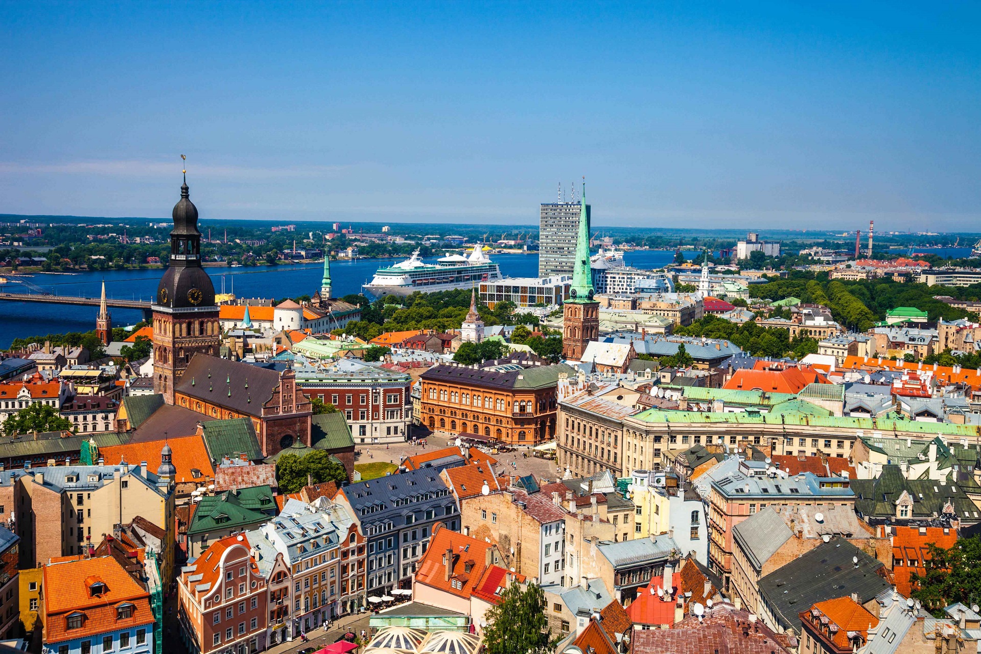
Riga (lettisch Rīga) ist die Hauptstadt Lettlands und mit rund 700.000 Einwohnern größte Stadt des Baltikums. Mit etwa einer Million Einwohnern in der Agglomeration ist Riga zudem der größte Ballungsraum in den drei baltischen Staaten. Riga ist politisches, wirtschaftliches und kulturelles Zentrum des Landes. Die alte Hansestadt ist berühmt für ihre Jugendstilbauten und ihre großzügige Anlage sowie für die gut erhaltene Innenstadt, darunter besonders die Altstadt. 2016 wurde Riga der Ehrentitel „Reformationsstadt Europas“ durch die Gemeinschaft Evangelischer Kirchen in Europa verliehen.[1]
里加(拉脱维亚语:Rīga, 英语:Riga)是拉脱维亚的首都,北欧地区波罗的海国家中最大、最繁忙的城市,位于波罗的海岸边,道加瓦河口。
里加是波罗的海国家主要的政治、经济、文化、教育和工商业中心。里加是历史上汉萨同盟主要商业城市,其历史中心被列入世界遗产名录,联合国教科文组织特别认为里加丰富的新艺术运动建筑是世界上独一无二的[2]。
欧盟欧洲电子通讯监管机构总部以及北大西洋公约组织的战略通讯中心设在里加。里加是欧洲城市组织及欧洲首都联盟组织成员。2014年欧洲文化之都,世界合唱比赛,2006年北大西洋公约组织峰会,2003年欧洲歌唱大赛,2006年世界男子冰球锦标赛,2003年世界女子冰壶球锦标赛等活动的举办地。
リガ、またはリーガ[1](ラトビア語: Rīga 発音 [ˈriːɡa] (![]() 音声ファイル)、ロシア語: Рига、エストニア語: Riia、リトアニア語: Ryga、英語、ドイツ語: Riga)は、ラトビア共和国の首都で、同国最大の人口を擁する都市。人口は69万9,203人(2012年時点)。「バルト海の真珠」と讃えられる美しい港町で、その旧市街はユネスコの世界遺産(文化遺産)に登録されている。 世界遺産に登録されている旧市街「リガ歴史地区」は約300棟のアールヌーボー調の建築物の宝庫として著名である。新市街は官庁やオフィスが集まる。郊外には、ラトビア民俗博物館があり、野外博物館も兼ねている。また、保養地として知られる海岸、ユールマーラも西方にある。人口約70万人のリガ市はラトビア国内はもとより、バルト三国最大の都市でもある。市内で最も高い建築物はリガラジオ&テレビタワーである。
音声ファイル)、ロシア語: Рига、エストニア語: Riia、リトアニア語: Ryga、英語、ドイツ語: Riga)は、ラトビア共和国の首都で、同国最大の人口を擁する都市。人口は69万9,203人(2012年時点)。「バルト海の真珠」と讃えられる美しい港町で、その旧市街はユネスコの世界遺産(文化遺産)に登録されている。 世界遺産に登録されている旧市街「リガ歴史地区」は約300棟のアールヌーボー調の建築物の宝庫として著名である。新市街は官庁やオフィスが集まる。郊外には、ラトビア民俗博物館があり、野外博物館も兼ねている。また、保養地として知られる海岸、ユールマーラも西方にある。人口約70万人のリガ市はラトビア国内はもとより、バルト三国最大の都市でもある。市内で最も高い建築物はリガラジオ&テレビタワーである。
Riga (/ˈriːɡə/; Latvian: Rīga [ˈriːɡa] ( listen), Livonian: Rīgõ) is the capital and largest city of Latvia. With 641,481 inhabitants (2016),[4] it is also the largest city in the three Baltic states, home to one third of Latvia's population and one tenth of the three Baltic states' combined population.[9] The city lies on the Gulf of Riga, at the mouth of the Daugava. Riga's territory covers 307.17 km2 (118.60 sq mi) and lies 1–10 m (3 ft 3 in–32 ft 10 in) above sea level,[10] on a flat and sandy plain.[10]
Riga was founded in 1201 and is a former Hanseatic League member. Riga's historical centre is a UNESCO World Heritage Site, noted for its Art Nouveau/Jugendstil architecture and 19th century wooden architecture.[11] Riga was the European Capital of Culture during 2014, along with Umeå in Sweden. Riga hosted the 2006 NATO Summit, the Eurovision Song Contest 2003, the 2006 IIHF Men's World Ice Hockey Championships and the 2013 World Women's Curling Championship. It is home to the European Union's office of European Regulators for Electronic Communications (BEREC).
In 2016, Riga received over 1.4 million visitors.[12] It is served by Riga International Airport, the largest and busiest airport in the Baltic states. Riga is a member of Eurocities,[13] the Union of the Baltic Cities (UBC)[14] and Union of Capitals of the European Union (UCEU).[15]
Riga (prononcé [ʁi.ga] ; en letton Rīga [riː.ga]) est la capitale de la Lettonie. Construite sur la mer Baltique au fond du golfe de Riga, dans lequel se jette la Daugava, c'est un centre industriel, commercial, culturel et financier majeur de la région de Vidzeme.
Riga (in lettone Rīga) è la capitale della Lettonia. Situata sul Mar Baltico alla foce del fiume Daugava, con 699.203 abitanti al censimento del 2011, è la città più grande delle Repubbliche Baltiche ed è uno dei principali centri culturali, politici ed economici della regione. Antico centro della lega anseatica, la città è gemellata con Firenze e Brema. Nel 2001 ha ospitato il Mese culturale europeo assieme a Basilea, mentre nel 2014 è stata Capitale europea della cultura affiancata ad Umeå.
Riga (en letón: Rīga [ˈriːɡa] (?·i)) es la capital y la mayor ciudad de Letonia. Es la ciudad más grande de los Estados bálticos y el hogar de más de un tercio de la población de Letonia.1 Es el mayor centro cultural, educativo, político, financiero, comercial e industrial de la región del mar Báltico.
La ciudad se encuentra en el golfo de Riga, en la desembocadura del río Daugava. Tiene un área de 307,17 km² y se encuentra en una llanura arenosa entre 1 y 10 metros sobre el nivel del mar.2
Riga fue fundada en 1201 y es un antiguo miembro de la Liga Hanseática. El centro histórico de Riga, declarado Patrimonio de la Humanidad por la Unesco, destaca por su arquitectura art nouveau y sus construcciones de madera del siglo XIX.3 La ciudad fue designada Capital Europea de la Cultura en 2014, junto a Umeå en Suecia.
La ciudad está comunicada por vía aérea gracias al Aeropuerto Internacional de Riga, el aeropuerto más grande de los países bálticos.
Riga es miembro de Eurocities,4 la unión de las ciudades bálticas (UBC)5 y la Unión de Capitales de la Unión Europea (UCEU).6
Ри́га (латыш. ![]() Rīga [ˈriːɡa], лив. Rīgõ) — столица Латвии и самый крупный город в Прибалтике с численностью населения 637 971 человека (2018 год)[2]. Политический, экономический и культурный центр страны. Находится на обоих берегах реки Даугавы, недалеко от её впадения в Рижский залив.
Rīga [ˈriːɡa], лив. Rīgõ) — столица Латвии и самый крупный город в Прибалтике с численностью населения 637 971 человека (2018 год)[2]. Политический, экономический и культурный центр страны. Находится на обоих берегах реки Даугавы, недалеко от её впадения в Рижский залив.
Рига долгое время была ганзейским городом, здесь соседствуют здания различных стилей от средневековой архитектуры старого города до модерна и современной архитектуры. Она была одним из крупнейших портов и одним из важнейших промышленных, коммерческих и культурных центров в Российской Империи. Исторический центр города внесен в список Всемирного наследия ЮНЕСКО[4]. В 2014 году Рига была выбрана одной из культурных столиц Европы[5].
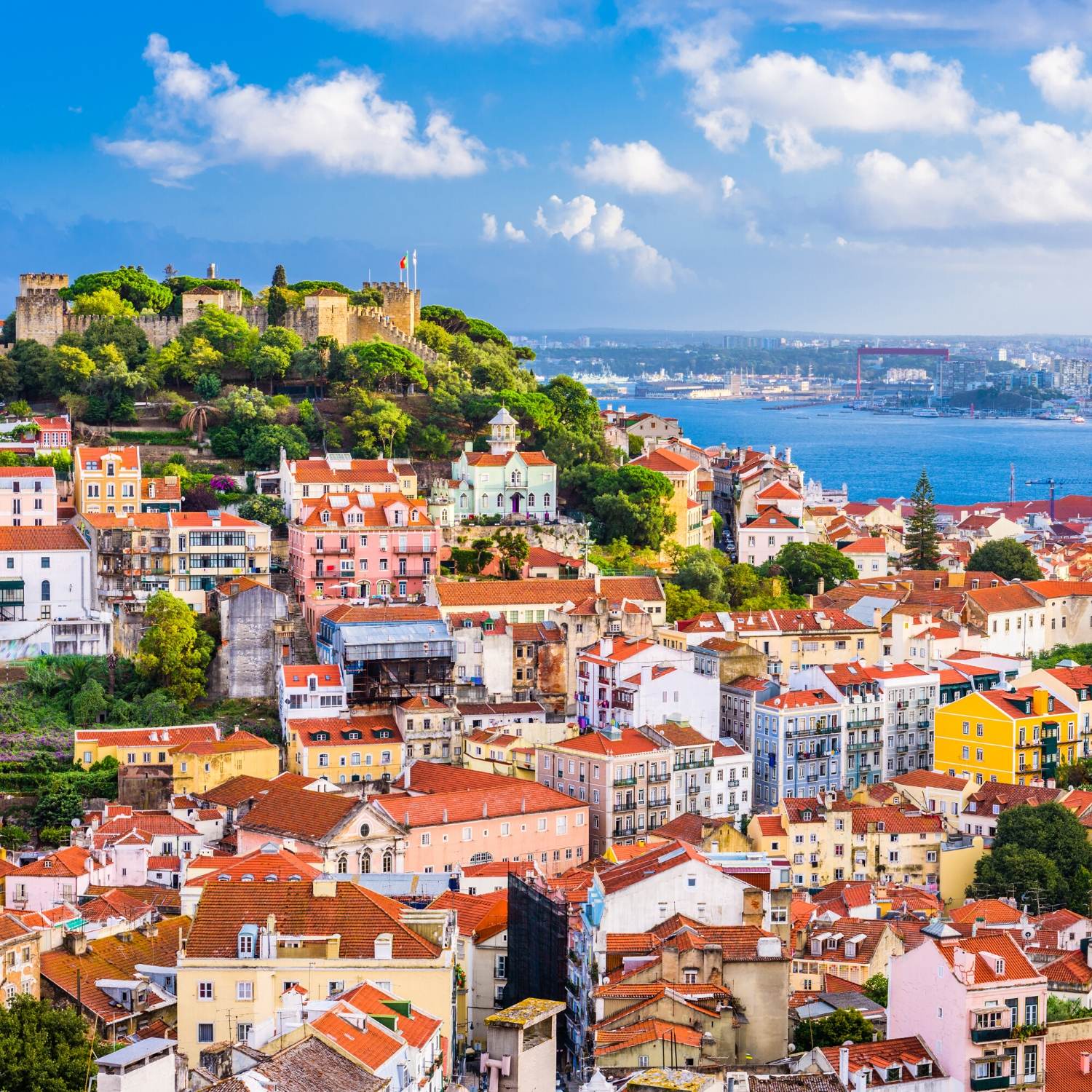
Lissabon (portugiesisch Lisboa [liʒˈβoɐ]) ist die Hauptstadt und die größte Stadt Portugals sowie des gleichnamigen Regierungsbezirks und liegt an einer Bucht der Flussmündung des Tejo im äußersten Südwesten Europas an der Atlantikküste der Iberischen Halbinsel.
Der Handelshafen an der Tejo-Bucht wurde vor der römischen Herrschaft Alis Ubbo genannt. Lissabon, eine Gründung der Phönizier, erhielt zu Zeiten Julius Caesars unter dem Namen Colonia Felicitas Iulia römisches Stadtrecht. 711 fiel der Ort wie der größte Teil der Iberischen Halbinsel an die Mauren; im Kontext des Zweiten Kreuzzugs wurde Lissabon 1147 portugiesisch und damit wieder unter christliche Herrschaft gestellt. Nach der Verlegung des Königssitzes von Coimbra wurde die Stadt im Jahr 1256 unter König Afonso III. zur Hauptstadt des Königreichs Portugal. Um 1500 erlebte Lissabon einen brillanten Aufstieg zu einer der glanzvollsten Handels- und Hafenstädte der damaligen Zeit.
Ein gewaltiges Erdbeben besiegelte im Jahr 1755 den wirtschaftlichen Niedergang der Stadt, der bereits Jahrzehnte zuvor schleichend eingesetzt hatte, und sorgte in ganz Europa für Aufsehen. Im 19. Jahrhundert erlebte Lissabon einen Wiederaufstieg.
In den letzten Jahren ist die Stadt allerdings massiv geschrumpft (von über 800.000 Einwohnern um 1980 auf etwa 500.000[3] um 2017); viele Menschen sind in das Umland gezogen. Lissabon hat mit erheblichen strukturellen Problemen zu kämpfen, unter denen vor allem die marode Bausubstanz vieler Gebäude und der enorme Straßenverkehr herausragen.
Als noch immer größte Stadt Portugals mit dem wichtigsten Hafen, dem Regierungssitz, den obersten Staats- und Regierungsbehörden, mehreren Universitäten und der Akademie der Wissenschaften ist Lissabon heute das politische, wirtschaftliche und kulturelle Zentrum des Landes.
Lissabon ist Sitz einiger Agenturen der Europäischen Union, darunter der Europäischen Beobachtungsstelle für Drogen und Drogensucht und der Europäischen Agentur für die Sicherheit des Seeverkehrs. Auch die Gemeinschaft der Portugiesischsprachigen Länder (CPLP) hat ihren Hauptsitz in Lissabon.
里斯本(葡萄牙语:Lisboa),亦称为葡京,是葡萄牙共和国的首都和最大都市。其位置位于葡萄牙中南部大西洋沿岸,城北为辛特拉山,城南为特茹河出海口,与伦敦、巴黎、罗马等同为西欧历史最悠久的城市。市区面积84.6平方公里、人口547,631人(2011年)。包含卫星城的都会区人口超过300万,相当于葡萄牙人口的27%左右。公元前205年起为罗马人统治,当时的统治者凯撒把这个地区升格为市,并命名为拉丁语:Felicitas Julia(意为“祝贺凯撒”)。1256年起正式成为葡萄牙王国的首都,从此发展成为欧洲和地中海一带重要的港口与贸易城市。地理大发现时代很多航海家都是由里斯本出发到世界不同的地方探险的,此后成为葡萄牙殖民帝国富甲一方的政治与商业中心,现今与波尔图同为葡萄牙两大代表性城市。
リスボン(ポルトガル語: Lisboa IPA: [ɫiʒˈboɐ] (![]() 音声ファイル)[1]、[liʒˈβoɐ] リジュボア[2]、英語: Lisbon IPA: [ˈlɪzbən])は、ポルトガルの首都で同国最大の都市である。市域人口は547,631人を擁し[3]、市域面積は84.8 km2 (33 sq mi)に過ぎないが、そのぶん高い人口密度を保持している。リスボンの都市的地域は行政区としての市域を越えて広がっており、人口は300万人を超え[4]、面積は958 km2 (370 sq mi)[4]を占めており、欧州連合域内では11番目に大きな都市圏 (en) を形成している。約3,035,000人[5][6] の人々が、リスボン都市圏に暮らし、ポルトガルの全人口の約27%を占めている。リスボンはヨーロッパの大都市では最も西にある都市であると同時に、ヨーロッパの中で最も西側に位置する政府首都でもある。ヨーロッパ諸国の首都のなかで唯一の大西洋岸にあるリスボンは、イベリア半島の西側、テージョ川の河畔に位置している。
音声ファイル)[1]、[liʒˈβoɐ] リジュボア[2]、英語: Lisbon IPA: [ˈlɪzbən])は、ポルトガルの首都で同国最大の都市である。市域人口は547,631人を擁し[3]、市域面積は84.8 km2 (33 sq mi)に過ぎないが、そのぶん高い人口密度を保持している。リスボンの都市的地域は行政区としての市域を越えて広がっており、人口は300万人を超え[4]、面積は958 km2 (370 sq mi)[4]を占めており、欧州連合域内では11番目に大きな都市圏 (en) を形成している。約3,035,000人[5][6] の人々が、リスボン都市圏に暮らし、ポルトガルの全人口の約27%を占めている。リスボンはヨーロッパの大都市では最も西にある都市であると同時に、ヨーロッパの中で最も西側に位置する政府首都でもある。ヨーロッパ諸国の首都のなかで唯一の大西洋岸にあるリスボンは、イベリア半島の西側、テージョ川の河畔に位置している。
リスボンは金融や商業、出版、娯楽、芸術、貿易、教育、観光と言った様々な分野で重要な都市であることから、世界都市と見なされている。[7][8] ポルテラ空港は2012年に1,530万人の旅客を扱い、高速道路Auto-estradaや高速列車アルファ・ペンドゥラールによりポルトガルの他の主要都市と結ばれている。[9]南ヨーロッパではイスタンブール、ローマ、バルセロナ、マドリード、アテネ、ミラノに次いで7番目に多くの観光客が訪れる都市で、2009年には1,740,000人の観光客が訪れた。[10]リスボンの総所得は世界の都市で32番目に高い位置を占めている。[11] ポルトガルの多国籍企業の本社はほとんどがリスボン地域に置いており、世界では9番目に多くの国際会議が開かれる都市でもある。[12]
また、ポルトガルの政治の中心でポルトガル政府の首府やポルトガルの大統領官邸が置かれている他、リスボン地域やリスボン県の中心でもある。
世界的にも古い歴史がある都市の一つで、西ヨーロッパでは最古の都市であり現代のヨーロッパの他の首都であるロンドンやパリ、ローマなどよりも数百年遡る。ガイウス・ユリウス・カエサルはフェリキタス・ユリアFelicitas Juliaと呼ばれるムニキピウムを創建し、オリピソOlissipoの名に加えた。5世紀から一連のゲルマン人部族により支配され、8世紀にはムーア人により攻略された。1147年、ポルトガル王国の建国者アフォンソ1世下のレコンキスタでのリスボン攻防戦で、ポルトガルはムーア人からリスボンを奪回する。以来、リスボンはポルトガルの主要な政治、経済、文化の中心となっている。ほとんどの首都と異なり、リスボンのポルトガルの首都としての地位は法令や書面の形式では公式に認められたり確認されていない。首都としての地位は憲法制定会議を通じて事実上の首都としてポルトガルの憲法に定められている。
リスボンには欧州薬物・薬物依存監視センター(EMCDDA)と欧州海上保安機関(EMSA)の2つの欧州連合の専門機関が置かれている。「ルゾフォニアの世界の首都」と呼ばれポルトガル語諸国共同体の本部がペナフィエル伯宮殿に置かれている。ベレンの塔とジェロニモス修道院の2つはUNESCOの世界遺産に登録されている。さらに1994年、リスボンは欧州文化首都になり、1998年にはリスボン国際博覧会が開催された。
Lisbon (/ˈlɪzbən/; Portuguese: Lisboa, IPA: [liʒˈboɐ] (![]() listen))[2] is the capital and the largest city of Portugal, with an estimated population of 505,526[1] within its administrative limits in an area of 100.05 km2.[3] Its urban area extends beyond the city's administrative limits with a population of around 2.8 million people, being the 11th-most populous urban area in the European Union.[4] About 3 million people live in the Lisbon Metropolitan Area (which represents approximately 27% of the country's population).[5] It is mainland Europe's westernmost capital city and the only one along the Atlantic coast. Lisbon lies in the western Iberian Peninsula on the Atlantic Ocean and the River Tagus. The westernmost areas of its metro area form the westernmost point of Continental Europe, which is known as Cabo da Roca, located in the Sintra Mountains
listen))[2] is the capital and the largest city of Portugal, with an estimated population of 505,526[1] within its administrative limits in an area of 100.05 km2.[3] Its urban area extends beyond the city's administrative limits with a population of around 2.8 million people, being the 11th-most populous urban area in the European Union.[4] About 3 million people live in the Lisbon Metropolitan Area (which represents approximately 27% of the country's population).[5] It is mainland Europe's westernmost capital city and the only one along the Atlantic coast. Lisbon lies in the western Iberian Peninsula on the Atlantic Ocean and the River Tagus. The westernmost areas of its metro area form the westernmost point of Continental Europe, which is known as Cabo da Roca, located in the Sintra Mountains
Lisbon is recognised as an alpha-level global city by the Globalization and World Cities (GaWC) Study Group because of its importance in finance, commerce, media, entertainment, arts, international trade, education and tourism.[6] Lisbon is the only Portuguese city besides Porto to be recognised as a global city.[7][8] It is one of the major economic centres on the continent, with a growing financial sector and one of the largest container ports on Europe's Atlantic coast.[9] Additionally, Humberto Delgado Airport served 26.7 million passengers in 2017, being the busiest airport in Portugal, the 3rd busiest in the Iberian Peninsula and the 20th busiest in Europe,[10] and the motorway network and the high-speed rail system of Alfa Pendular links the main cities of Portugal (such as Braga, Porto and Coimbra) to Lisbon.[11] The city is the 9th-most-visited city in Southern Europe, after Rome, Istanbul, Barcelona, Milan, Venice, Madrid, Florence and Athens, with 3,320,300 tourists in 2017.[12] The Lisbon region contributes with a higher GDP PPP per capita than any other region in Portugal. Its GDP amounts to 96.3 billion USD and thus $32,434 per capita.[13][14] The city occupies the 40th place of highest gross earnings in the world.[15] Most of the headquarters of multinationals in the country are located in the Lisbon area.[16] It is also the political centre of the country, as its seat of Government and residence of the Head of State.
Lisbon is one of the oldest cities in the world, and one of the oldest in Western Europe, predating other modern European capitals such as London, Paris and Rome by centuries. Julius Caesar made it a municipium called Felicitas Julia, adding to the name Olissipo. Ruled by a series of Germanic tribes from the 5th century, it was captured by the Moors in the 8th century. In 1147, the Crusaders under Afonso Henriques reconquered the city and since then it has been a major political, economic and cultural centre of Portugal. Unlike most capital cities, Lisbon's status as the capital of Portugal has never been granted or confirmed officially – by statute or in written form. Its position as the capital has formed through constitutional convention, making its position as de facto capital a part of the Constitution of Portugal.
Lisbonne [liz.bɔn]2 (en portugais : Lisboa [liʒˈboɐ]3 Écouter) est la capitale et la plus grande ville du Portugal. Considérée comme une « ville mondiale » selon le classement 2010 du Réseau d’étude sur la mondialisation et les villes mondiales (GaWC)4 comme Taipei, Miami, Varsovie ou Munich, Lisbonne est également le chef-lieu du district de Lisbonne, du Grand Lisbonne et de la zone métropolitaine de Lisbonne. Ses habitants sont habituellement appelés Lisboètes (du portugais lisboeta), mais on rencontre aussi les termes Lisbonnin et Lisbonnais.
D'après le recensement de 2011, la municipalité compterait une population de 545 733 habitants5, répartie sur une surface de 83,7 km2. L'agglomération de Lisbonne (Grand Lisbonne) compte une population légèrement supérieure à 2,042 millions d'habitants (NUTS III), ce qui en fait la 15e agglomération européenne en importance. Son aire urbaine (Région de Lisbonne) compte quant à elle 2 821 876 habitants (NUTS II), représentant 26,7 % de la population portugaise. C'est la ville la plus riche du Portugal, avec un PIB par habitant supérieur au PIB moyen de l'Union européenne.
Située à l'embouchure du Tage, la municipalité est divisée en 24 freguesias (paroisses civiles ou arrondissements). Elle est limitée par les communes de Odivelas et Loures au nord, Oeiras à l'ouest, Amadora au nord-ouest et l'estuaire du Tage (la mer de Paille) au sud-est, au travers duquel, la ville est au contact des municipalités de la rive sud : Almada, Seixal, Barreiro, Moita, Montijo et Alcochete.
Deux agences européennes ont leur siège à Lisbonne : l'Observatoire européen des drogues et des toxicomanies et l'Agence européenne pour la sécurité maritime, toutes les deux avec des projets de nouveaux sièges près du fleuve. L'organisation de la Communauté des pays de langue portugaise a également ses bureaux dans la capitale portugaise.
Lisbona (/liz'bona/; in portoghese: Lisboa, /liʒ'boɐ/) è la capitale e principale città del Portogallo, con una popolazione di circa 506 892 abitanti all'interno dei suoi confini amministrativi, mentre circa 2,8 milioni sono gli abitanti della sua area urbana (undicesima nell'Unione Europea). È la capitale europea più occidentale (isole escluse) e l'unica ad affacciarsi sull'Oceano Atlantico. La città è situata nella parte occidentale della Penisola iberica, presso l'estuario del fiume Tago, ed inoltre la parte più occidentale della sua area urbana è la zona geografica più occidentale dell'intera Europa continentale.
Lisbona è considerata una città globale in virtù della sua discreta importanza in settori come finanza, commercio, editoria, arte, commercio internazionale, istruzione e turismo. È un importante centro economico, con un settore finanziario in crescita ed uno tra i più importanti porti affaccianti sull'Atlantico. L'aeroporto di Lisbona serve circa 20 milioni di passeggeri all'anno e importanti strade e autostrade collegano la capitale alle altre città portoghesi. La città è la settima più visitata nel Sud Europa, dopo Istanbul, Roma, Barcellona, Madrid, Atene e Milano, con 1 740 000 turisti nel 2009. La regione di Lisbona ha un PIL procapite considerevolmente più alto della media nazionale, classificandosi al decimo posto nella UE con 110 miliardi di euro e 39.375€ pro capite, dato del 40% più alto rispetto alla media dell'unione. La maggior parte dei quartier generali delle multinazionali portoghesi è localizzata in città, che è anche il maggior centro politico dello stato, essendo sede del Governo e della Presidenza della Repubblica.
Lisboa (pronunciación en portugués: ![]() [liʒˈβoɐ] (?·i)) es la capital1 y mayor ciudad de Portugal. Situada en la desembocadura del río Tajo (Tejo), es la capital del país, capital del distrito de Lisboa, de la región de Lisboa, del Área Metropolitana de Lisboa, y es también el principal centro de la subregión de la Gran Lisboa. La ciudad tiene una población de 547 773 habitantes y su área metropolitana se sitúa en los 2 810 923 en una superficie de 2921,90 km². Esta área contiene el 20 % de la población del país. Lisboa es la ciudad más rica de Portugal[cita requerida].
[liʒˈβoɐ] (?·i)) es la capital1 y mayor ciudad de Portugal. Situada en la desembocadura del río Tajo (Tejo), es la capital del país, capital del distrito de Lisboa, de la región de Lisboa, del Área Metropolitana de Lisboa, y es también el principal centro de la subregión de la Gran Lisboa. La ciudad tiene una población de 547 773 habitantes y su área metropolitana se sitúa en los 2 810 923 en una superficie de 2921,90 km². Esta área contiene el 20 % de la población del país. Lisboa es la ciudad más rica de Portugal[cita requerida].
El municipio de Lisboa, que coincide con la ciudad propiamente dicha (excluyendo la aglomeración urbana continua, más grande, que la rodea), tiene una extensión de 100,05 km², en los que en 2011 vivían 547 733 habitantes.2 Su densidad demográfica es de 5 474,59 hab/km². El municipio se subdivide en 24 freguesias (parroquias) y limita al norte con los municipios de Odivelas y Loures, al oeste con Oeiras, al noroeste con Amadora y al sureste con el estuario del Tajo. A través del estuario, Lisboa se une a los municipios de la Margen Sur: Almada, Seixal, Barreiro, Moita, Montijo y Alcochete.
Лиссабо́н[4], Лисабо́н[5][6] (порт. Lisboa, МФА (порт.): [liʒˈβoɐ]) — столица, крупнейший город и главный порт Португалии.
Лиссабон является одним из старейших городов мира и старейшим городом Западной Европы, на века превосходя в возрасте такие современные европейские столицы, как Лондон, Париж.
В Лиссабоне средиземноморский климат. В нём самые теплые зимы среди всех европейских метрополий — средние температуры с декабря по февраль составляют 18 °C днем и 11 °C ночью. Типичный летний сезон длится около шести месяцев — с мая по октябрь, хотя и в апреле температура порой достигает 25-32 °C.

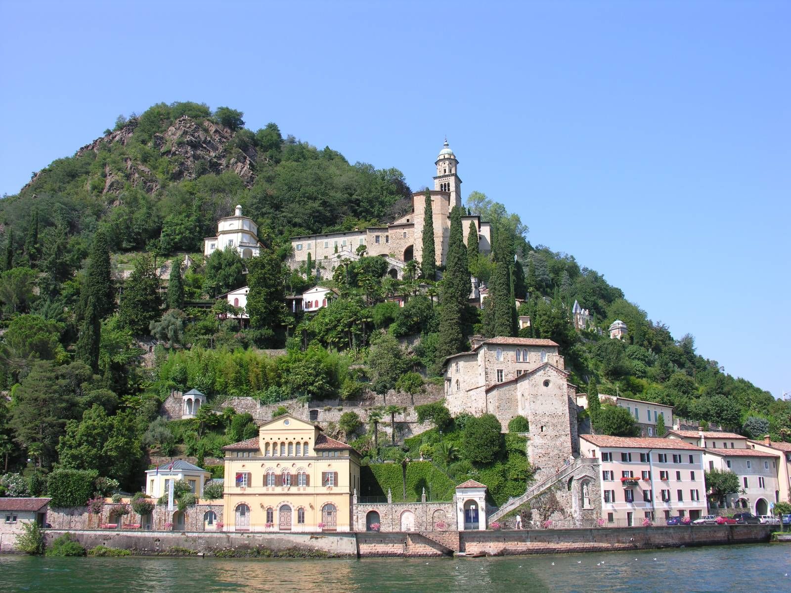
Luganoⓘ/? (lombardisch Lügàn [lyˈgaŋ, lyˈgeɲ],[6] deutsch veraltet Lauis, rätoromanisch Ligiaunⓘ/?) ist eine Stadt und politische Gemeinde im Bezirk Lugano des Schweizer Kantons Tessin. Sie liegt im Sottoceneri und ist die grösste politische Gemeinde des Kantons. Sie ist in die Kreise Lugano West, Lugano Ost und seit 2013 auch Lugano Nord gegliedert.
Die Stadt ist nach Zürich und Genf der drittgrösste Finanzplatz der Schweiz. Seit den Eingemeindungen von Brè-Aldesago, Castagnola-Cassarate im Jahr 1972, Breganzona, Cureggia, Davesco-Soragno, Gandria, Pambio-Noranco, Pazzallo, Pregassona und Viganello (2004), dann Barbengo, Carabbia und Villa Luganese im Jahr 2008 und von Bogno, Cadro, Carona, Certara, Cimadera, Sonvico und Val Colla im Jahr 2013 ist Lugano flächenmässig die siebtgrösste Schweizer Stadt, belegt den neunten Platz hinsichtlich der Einwohnerzahl und den zehnten Platz bezüglich der vorhandenen Arbeitsplätze. In der Agglomeration der Stadt leben rund 150'000 Menschen.
Die Buchstaben LVGA im Wappen stehen für die Anfangsbuchstaben des Ortsnamens.[7] Die Stadt ist die grösste italienischsprachige politische Gemeinde ausserhalb Italiens.
卢加诺(义大利语:Lugano,意大利语发音:[luˈɡaːno];德语:Lauis)是瑞士提契诺州的一个意大利语区城市,也是最南端的城市。人口63,583(2015年10月),面积26.2平方公里,是瑞士第九大城市,也是提契诺州最大的城市,同时也是意大利之外最大的意大利语聚集区。官方语言是意大利语。城市地处卢加诺湖,被卢加诺山脉所包围。
卢加诺(Lugano,Lauis)建于公元六世纪,是瑞士Ticino州的首府,同时也是是瑞士南边与意大利接壤的一个湖边乐园,瑞士意大利语区的一个 重镇,人口3万多,主要信仰罗马天主教。卢加诺环境与气候宜人,即使在冬季也是充满温暖的阳光。在巍峨高山的怀抱和齐花异草的簇拥之中,这是一个在卢加诺 湖畔散发这光明和活力的城市。由于禁止汽车通行所以环境份外整洁清净。卢加诺的特色购物设施齐全,环境优美,珠宝店钟表店比比皆是。市内多为意大利风格的 建筑物,置身其中仿如在意大利的市镇,游客可悠闲漫步其间,绿树成荫,景色怡人。地中海的气候和悠闲的环境令人流连忘返,与多数欧美市镇大不一样的是,该 市入夜后仍非常热闹。 主要收入来自于观光业和国际金融,卢加诺的两个最具象征性的建筑物是圣罗伦佐天主教堂和圣玛利亚大教堂。
卢加诺滨临卢加诺湖(Luganer See)而建,湖跨越瑞,意边界,湖畔苍翠的树木犹如一道油绿滚边,周围岩峰矗立,繁花争艳,使城墙像个五官俏丽的少女.到了夜晚,岸上辉煌灯火倒映湖 中,更添妖媚姿态。卢加诺湖正对面即为圣萨尔瓦多山(Mounte San Salvatore),山上即为卢加诺市郊住宅区,湖船也是连结卢加诺与临近湖边小镇的重要交通工具,如Carona、Gandria、Bissone, 这些都还维持着中世纪小渔村所特有的古典风情.
卢加诺有着多彩的文化、户外活动、能满足旅客的各种需要,尤其是每年七月都会举办爵士音乐节,至今已有19年,由世界著名音乐家免费露天表演。 每年八月底举行大型乐曲、爵士乐、流行音乐和乡谣音乐的庆典活动,合共有100多个小时的免费音乐会。 6月中旬至8月放映湖边电影系列。(Quelle: http://www.offid.net/travel/c449/brief.html)
 欧洲联盟
欧洲联盟
 欧盟的历史
欧洲联盟
*创始国
欧洲流行歌曲大赛
欧盟的历史
欧洲联盟
*创始国
欧洲流行歌曲大赛
 财政金融
***全球金融中心
财政金融
***全球金融中心
 地理
地理
***IMF发达国家
地理
地理
***IMF发达国家
 历史
公元 1500 - 2000
历史
公元 2000 - 2100
历史
公元 1500 - 2000
历史
公元 2000 - 2100
 国际城市
*欧洲文化之都
国际城市
欧洲城市
IMF发达国家
IMF发达国家
第六级
卢森堡
国际城市
*欧洲文化之都
国际城市
欧洲城市
IMF发达国家
IMF发达国家
第六级
卢森堡
 北约会员国
北约会员国
 欧洲国家
欧洲国家

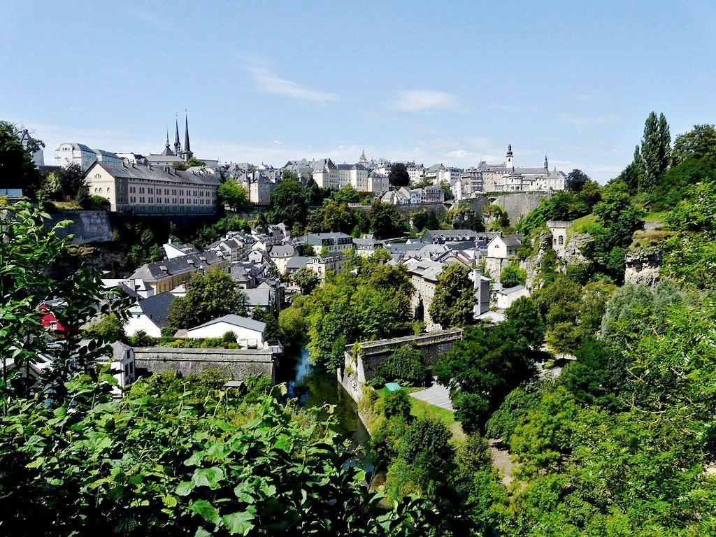
Das Großherzogtum Luxemburg (luxemburgisch Groussherzogtum Lëtzebuerg [ˈgʀəʊsˌhɛχtsoːktuːm ˈlətsəbuəɕ], französisch Grand-Duché de Luxembourg [ɡʁɑ̃ dyʃe də lyksɑ̃buʁ]) ist ein demokratischer Staat in Form einer parlamentarischen Monarchie[1] im Westen Mitteleuropas. Es ist das letzte Großherzog- bzw. Großfürstentum (von einst zwölf) in Europa. Das Land gehört zum mitteldeutschen Sprachraum. Landessprache ist Luxemburgisch, Verwaltungs- und Amtssprachen sind Französisch, Deutsch und Luxemburgisch. Gemeinsam mit seinem Nachbarn Belgien und mit den Niederlanden bildet Luxemburg die Beneluxstaaten.
卢森堡大公国(卢森堡语:Groussherzogtum Lëtzebuerg,法语:Grand-Duché de Luxembourg,德语:Großherzogtum Luxemburg),简称“卢森堡”,位于欧洲西北部,被邻国法国、德国和比利时包围,是一个内陆小国,也是现今欧洲大陆仅存的大公国,首都卢森堡市。因国土小、古堡多,又有“袖珍王国”、“千堡之国”的称呼 。
卢森堡地形富于变化,在历史上又处于德法要道,地势险要,一直是西欧重要的军事要塞,有北方直布罗陀的称号 。
卢森堡是一个高度发达的资本主义国家,也是欧盟和北约创始成员国之一,拥有欧盟多个下设机构,如欧洲法院、欧洲审计院以及欧洲投资银行,被称为继布鲁塞尔和斯特拉斯堡之后的欧盟“第三首都”。同时是高度发达的工业国家,还是欧元区内最重要的私人银行中心,及全球第二大仅次于美国的投资信托中心。金融、广播电视、钢铁是其三大经济支柱产业,该国失业率极低,人均寿命80岁。
卢森堡大公国(卢森堡语:Groussherzogtum Lëtzebuerg[注 1];法语:Grand-Duché de Luxembourg; 德语:Großherzogtum Luxemburg[注 2]),通称卢森堡(卢森堡语:Lëtzebuerg;法语:Luxembourg;德语:Luxemburg),被邻国法国、德国和比利时包围,是一个位于欧洲的内陆国家,也是现今欧洲大陆仅存的大公国,首都卢森堡市。卢森堡是欧盟成员国,因境内有欧洲法院、欧洲审计院、欧洲投资银行等多个欧盟机构被称为继布鲁塞尔和斯特拉斯堡之后的欧盟“第三首都”。
ルクセンブルク大公国(ルクセンブルクたいこうこく)、通称ルクセンブルクは、西ヨーロッパに位置する立憲君主制国家。首都は国名と同名のルクセンブルク市。隣接国は、南のフランス、西と北のベルギー、東のドイツである。ベルギー、オランダと併せてベネルクスと呼ばれる。
Luxembourg (/ˈlʌksəmbɜːrɡ/ ( listen)) (Luxembourgish: Lëtzebuerg [ˈlətsəbuə̯ɕ] ( listen); French: Luxembourg ; German: Luxemburg), officially the Grand Duchy of Luxembourg,[note 2] is a small landlocked country in western Europe. It is bordered by Belgium to the west and north, Germany to the east, and France to the south. Its capital, Luxembourg City, together with Brussels and Strasbourg, is one of the three official capitals of the European Union[6] and the seat of the European Court of Justice, the highest judicial authority in the EU. Its culture, people, and languages are highly intertwined with its neighbours, making it essentially a mixture of French and German cultures, as evident by the nation's three official languages: French, German, and the national language, Luxembourgish (sometimes considered a dialect of German). The repeated invasions by Germany, especially in World War II, resulted in the country's strong will for mediation between France and Germany and, among other things, led to the foundation of the European Union.[7]
With an area of 2,586 square kilometres (998 sq mi), it is one of the smallest sovereign states in Europe.[8] In 2016, Luxembourg had a population of 576,249, which makes it one of the least-populous countries in Europe,[9] but by far the one with the highest population growth rate.[10] Foreigners account for nearly half of Luxembourg's population.[11] As a representative democracy with a constitutional monarch, it is headed by Grand Duke Henri and is the world's only remaining grand duchy. Luxembourg is a developed country, with an advanced economy and one of the world's highest GDP (PPP) per capita. The City of Luxembourg with its old quarters and fortifications was declared a UNESCO World Heritage Site in 1994 due to the exceptional preservation of the vast fortifications and the old city.[12]
The history of Luxembourg is considered to begin in 963, when count Siegfried I acquired a rocky promontory and its Roman-era fortifications known as Lucilinburhuc, ′little castle′, and the surrounding area from the Imperial Abbey of St. Maximin in nearby Trier.[13][14] Siegfried's descendants increased their territory through marriage, war and vassal relations. At the end of the 13th century, the Counts of Luxembourg reigned over a considerable territory. [15] In 1308, Henry VII, Count of Luxembourg became King of the Germans and Holy Roman Emperor. The House of Luxembourg produced four Holy Roman Emperors at the high time of the Middle Ages. In 1354, Charles IV elevated the County to the Duchy of Luxembourg. Since Sigismund had no male heir, the Duchy became part of the Burgundian Circle and then one of the Seventeen Provinces of the Habsburg Netherlands.[16] Over the centuries, the City and Fortress of Luxembourg, of great strategic importance situated between the Kingdom of France and the Habsburg territories, was gradually built up to be one of the most reputed fortifications in Europe. After belonging to both the France of Louis XIV and the Austria of Maria Theresia, Luxembourg became part of the First French Republic and Empire under Napoleon.[17]
The present-day state of Luxembourg first emerged at the Congress of Vienna in 1815. The Grand-Duchy, with its powerful fortress, became an independent state under the personal possession of William I of the Netherlands with a Prussian garrison to guard the city against another invasion from France. [18] In 1839, following the turmoil of the Belgian Revolution, the purely Oil-speaking part of Luxembourg was ceded to Belgium and the Luxembourgish-speaking part (except the Arelerland, the area around Arlon) became what is the present state of Luxembourg. [19]
The steel industry exploiting the Red Lands' rich iron-ore grounds in the beginning of the 20th century drove the country's industrialisation. ArcelorMittal, the world's largest steel producer with headquarters in Luxembourg City, is still a reminder of these times. After the decline of the steel industry in the 1970s, the country focused on establishing itself as a global financial centre and developed into the banking hub it is reputed for. Since the beginning of the 21st century, its governments have focused on developing the country into a knowledge economy, with the founding of the University of Luxembourg and a national space programme, projecting the first involvement in a robotic lunar expedition by 2020.[20]
Luxembourg is a founding member of the European Union, OECD, United Nations, NATO, and Benelux. The city of Luxembourg, which is the country's capital and largest city, is the seat of several institutions and agencies of the EU. Luxembourg served on the United Nations Security Council for the years 2013 and 2014, which was a first in the country's history.[21] In 2016 Luxembourgish citizens had visa-free or visa-on-arrival access to 172 countries and territories, ranking the Luxembourgish passport 15th in the world, tied with countries such as Canada and Switzerland.[22]
Le Luxembourg, en forme longue le Grand-Duché de Luxembourg2,b,c ou le grand-duché de Luxembourgd, en luxembourgeois Lëtzebuerg et Groussherzogtum Lëtzebuerg, en allemand Luxemburg et Großherzogtum Luxemburg, est un pays d'Europe de l'Ouest sans accès à la mere Il est bordé par la Belgique à l'ouest et au nord, l'Allemagne à l'est, et la France au sud. Il comprend deux régions principales : l'Oesling au nord, qui est une partie du massif des Ardennes, et le Gutland au sud, prolongement de la Lorraine au sens géologique du terme. Le Luxembourg compte 602 005 habitants au 1er janvier 20181, et s'étend sur une superficie de 2 586 km2, faisant de lui l'une des plus petites nations souveraines d'Europe.
Le Luxembourg est une démocratie représentative et une monarchie constitutionnelle avec un grand-duc pour chef d'État, faisant du pays le seul grand-duché encore existant. Son économie dynamique en fait un des pays les plus riches et des plus prospères du monde, avec le PIB par habitant le plus élevé du monde selon le FMI en 2014. L'économie est principalement centrée sur les activités financières (environ la moitié du produit intérieur brut), favorisée par une fiscalité attractive voire dérisoire dans certains domaines (quasi-exonération d'impôts pour les bénéfices issus de l'exploitation de brevets ou de logiciels). La localisation centrale du territoire luxembourgeois en Europe a historiquement fait de lui un lieu d'une grande importance stratégique pour de nombreuses puissances, depuis sa fondation en tant que fortin romain7, son accueil d'un château franc durant le Haut Moyen Âge, et son rôle de bastion pour le chemin des Espagnols entre les XVIe et XVIIe siècles.
Le Luxembourg est le plus petit membre fondateur de l'Union européenne, de la zone euro, de l'OTAN, de l'OCDE, de l'ONU, de l'OSCE, du Conseil de l'Europe8,9,10,11 et du Benelux, reflétant son consensus politique en faveur de l'intégration économique, politique et militaire. La ville de Luxembourg, sa capitale et sa plus grande ville, est le siège de plusieurs établissements et institutions de l'UE. En 2012, le Luxembourg a été élu pour la première fois de son histoire à un siège temporaire au Conseil de sécurité des Nations unies. En raison de sa position géographique, la culture luxembourgeoise est une fusion de l'Europe germanique et romane, intégrant chacune des deux. De ce fait, le Luxembourg est un pays trilingue : le luxembourgeois, le français et l'allemand sont les trois langues officielles et, depuis 1984, le luxembourgeois a légalement le statut de « langue nationale »12.
Il Granducato di Lussemburgo (in francese: le Grand-Duché de Luxembourg; in lussemburghese: Groussherzogtum Lëtzebuerg; in tedesco: Großherzogtum Luxemburg) è un paese membro dell'Unione europea situato tra Germania, Francia e Belgio. È uno stato senza sbocco sul mare.
Membro fondatore dell'Unione europea, della NATO, del Benelux e delle Nazioni Unite, la sua capitale, l'omonima città di Lussemburgo, è sede di numerose istituzioni e agenzie europee oltre ad essere uno snodo finanziario di primaria importanza.
È l'unico granducato rimasto al mondo.
Luxemburgo, oficialmente denominado Gran Ducado de Luxemburgo (luxemburgués: Groussherzogtum Lëtzebuerg, francés: Grand-Duché de Luxembourg, alemán: Großherzogtum Luxemburg), es un pequeño país de Europa Central que forma parte de la Unión Europea. Se trata de un Estado sin litoral, rodeado por Francia, Alemania y Bélgica. Luxemburgo cuenta con una población de medio millón de habitantes sobre un área de 2586 kilómetros cuadrados.1
El gobierno de Luxemburgo es una monarquía constitucional y parlamentaria, siendo el único gran ducado soberano en la actualidad. El Estado tiene una economía altamente desarrollada, con el mayor producto interior bruto por cápita del mundo de acuerdo al Banco Mundial, y el segundo de acuerdo al Fondo Monetario Internacional.
Luxemburgo es miembro de la Unión Europea, la Organización del Tratado del Atlántico Norte, la Organización para la Cooperación y el Desarrollo Económico, las Naciones Unidas y el Benelux, reflejando la orientación política a favor de la integración económica, política y militar. Su capital, Luxemburgo, es sede de numerosas instituciones y agencias de la Unión Europea.
Luxemburgo posee culturas y tradiciones diversas por encontrarse entre la Europa romana y la Europa germánica. El país tiene tres lenguas oficiales: alemán, francés y luxemburgués. La localidad Schengen, que dio su nombre al espacio de Schengen, está ubicada en Luxemburgo.
Люксембу́рг (люксемб. Lëtzebuerg), официально Вели́кое Ге́рцогство Люксембу́рг (люксемб. Groussherzogtum Lëtzebuerg, фр. Grand-Duché de Luxembourg, нем. Großherzogtum Luxemburg) — государство (великое герцогство) в Западной Европе. Граничит с Бельгией на севере, на западе и на юге с Францией, на востоке с Германией, не имеет выхода к морю. Название происходит от древневерхненемецкого «lucilinburch» — «малый город». Общая площадь Люксембурга составляет 2586,4 км², что делает его одним из самых маленьких суверенных государств в Европе[5]. Население на 1 января 2018 года составляет 602 005 человек[2].
Член Европейского союза с 1957 года, также является членом НАТО, ОЭСР и ООН. Вместе с Бельгией и Нидерландами входит в состав Бенилюкса.