漢德百科全書 | 汉德百科全书

       
Chinese — German
Catalog Ningxia Huizu Zizhiqu-NX

Plateau der Inneren Mongolei
内蒙古高原是中国四大高原中的第二大高原,为蒙古高原的一部分,又称北部高原,狭义上的内蒙古高原位于阴山山脉之北,大兴安岭以西,北至国界,西至东经106°附近。介于北纬40°20′~50°50′,东经106°~121°40′。面积约34万平方千米。广义的内蒙古高原还包括阴山以南的鄂尔多斯高原和贺兰山以西的阿拉善高原,面积约70万平方千米。内蒙古高原是中国重要的牧场,草原面积约占高原面积的80%,属欧亚温带草原区的一部分,是中国最大的绵羊及山羊放牧区和中国骆驼主要产区之一。内蒙古高原平均每平方千米仅3人,为蒙古族、达斡尔族、鄂温克族、鄂伦春族和汉族等各族人民长期从事畜牧业生产活动的地区。
 http://www.net4info.de/photos/cpg/albums/userpics/10001/Nei20Meng20Gu20Gao20Yuan20.jpg

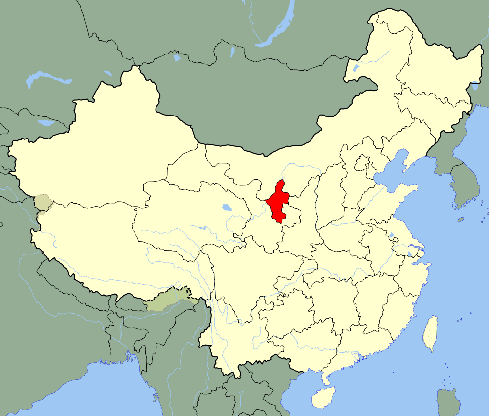
Das Plateau der Inneren Mongolei (內蒙古高原, Nei Menggu gaoyuan) ist ein sich quer über den Norden Chinas erstreckendes Hochland. Zusammen mit seiner west- und nördlichen Fortsetzung (Mongolisches Plateau) ist es das zweitgrößte Hochland Chinas nach dem Qinghai-Tibet-Plateau. Es reicht im Osten vom Großen Hinggan-Gebirge bis im Westen zum Mazu-Gebirge (馬鬃山 Mazu Shan) und Sukexielu Shan 苏克斜鲁山, im Süden entlang der Großen Mauer und im Norden grenzt es an die Mongolische Volksrepublik.

Das Plateau der Inneren Mongolei umfasst das gesamte Gebiet der Inneren Mongolei und einen Teil von Gansu, Ningxia und Hebei. Von West nach Ost ist es über 2000 Kilometer lang und von Nord nach Süd ca. 500 Kilometer. Das Plateau ist im Allgemeinen 1000 bis 1400 m hoch. Im Osten ist es niederschlagsreicher als im Westen.

Den Südteil des Plateaus bilden das Ordos-Plateau (鄂爾多斯高原) und die schmale fruchtbare Hetao-Ebene (河套平原, Hetao pingyuan). Im Ostteil und Nordteil liegen das Hulun-Buir-Plateau (呼倫貝爾高原), das Ujumqin-Becken (乌珠穆沁盆地, Wuzhumuqin pendi), das Xilin-Gol-Plateau (錫林郭勒高原) und das Ulanqab-Plateau (烏蘭察布高原), im Westen das Bayan-Nur-Plateau (巴彥淖爾高原) und das Alxa-Plateau (阿拉善高原). Das in Ostwest-Richtung verlaufende Yinshan-Gebirge (阴山, Yin Shan) liegt in seiner Mitte.


This image, video or audio may be copyrighted. It is used for educational purposes only. If you find it, please notify us byand we will remove it immediately.
Najiahu-Moschee
/assets/contentimages/Na20Jia20Hu20Qing20Zhen20Si20.jpg
This image, video or audio may be copyrighted. It is used for educational purposes only. If you find it, please notify us byand we will remove it immediately.
Nanguan-Moschee
/assets/contentimages/Yin20Chuan20Nan20Guan20Qing20Zhen20Si20.jpg
This image, video or audio may be copyrighted. It is used for educational purposes only. If you find it, please notify us byand we will remove it immediately.
Ningxia-Museum
This image, video or audio may be copyrighted. It is used for educational purposes only. If you find it, please notify us byand we will remove it immediately.
Ningxia-Universität
http://www.net4info.de/photos/cpg/albums/userpics/10002/Zhu20Xia20Da20Xue20.jpg
This image, video or audio may be copyrighted. It is used for educational purposes only. If you find it, please notify us byand we will remove it immediately.
Ningxia Television
This image, video or audio may be copyrighted. It is used for educational purposes only. If you find it, please notify us byand we will remove it immediately.
Ningxia-Reisekarte
http://www.net4info.de/photos/cpg/albums/userpics/10002/Zhu20Xia20Lu20You20Di20Tu20.png
This image, video or audio may be copyrighted. It is used for educational purposes only. If you find it, please notify us byand we will remove it immediately.
Ningxia-Ebene
宁夏平原又称银川平原,位于宁夏回族自治区中部黄河两岸。 宁夏平原北起石嘴山,南止黄土高原,东到鄂尔多斯高原,西接贺兰山。北部是黄河冲积平原——宁夏平原,面积1.7万平方公里,滔滔黄河斜贯其间,流程397公里,水面宽阔,水流平缓。 宁夏平原沿黄两岸地势平坦,早在2000多年以前先民们就凿渠引水,灌溉农田,秦渠、汉渠、唐渠延名、流淌,形成了大面积的自流灌溉区。

 /assets/contentimages/Zhu20Xia20Ping20Yuan20.jpg

宁夏平原又称银川平原,位于宁夏回族自治区中部黄河两岸。北起石咀山,南止黄土高原,东到鄂尔多斯高原,西接贺兰山。北部是黄河冲积平原——宁夏平原,面积1.7万平方公里,滔滔黄河斜贯其间,流程397公里,水面宽阔,水流平缓。沿黄两岸地势平坦,早在2000多年以前先民们就凿渠引水,灌溉农田,秦渠、汉渠、唐渠延名至今,流淌至今,形成了大面积的自流灌溉区。

This image, video or audio may be copyrighted. It is used for educational purposes only. If you find it, please notify us byand we will remove it immediately.
Ningxia Medical University
/assets/contentimages/Zhu20Xia20Yi20Ke20Da20Xue20.jpeg
This image, video or audio may be copyrighted. It is used for educational purposes only. If you find it, please notify us byand we will remove it immediately.
Autonomes Gebiet Ningxia
/assets/contentimages/Zhu20Xia20Hui20Zu20Zi20Zhi20Qu20.png
This image, video or audio may be copyrighted. It is used for educational purposes only. If you find it, please notify us byand we will remove it immediately.
Volksregierung der autonomen Region Ningxia der Hui-Nationalität/People´s Government of Ningxia Hui Autonomous Region
http://www.net4info.de/photos/cpg/albums/userpics/10001/Zhu20Xia20Hui20Zu20Zi20Zhi20Qu20Ren20Min20Zheng20Fu20.png
This image, video or audio may be copyrighted. It is used for educational purposes only. If you find it, please notify us byand we will remove it immediately.
Ningxia Daily
This image, video or audio may be copyrighted. It is used for educational purposes only. If you find it, please notify us byand we will remove it immediately.