
Deutsch-Chinesische Enzyklopädie, 德汉百科
 Croatia
 History
 Afghanistan
Egypt
Albania
Antigua and Barbuda
Argentina
Armenia
Azerbaijan
Bahrain
Bangladesh
Barbados
Beijing Shi-BJ
Belarus
Belgium
Amber Road
Bolivia
Bosnia Herzegovina
Bulgaria
Chile
China
Chongqing Shi-CQ
Columbia
Costa Rica
Cuba
Demokratische Republik Timor-Leste
Dominica
Dominikanische Republik
Ecuador
Eritrea
Fidschi
Fujian Sheng-FJ
Gansu Sheng-GS
Georgia
Grenada
Greece
Guangdong Sheng-GD
Guangxi Zhuangzu Zizhiqu-GX
Guyana
Hainan Sheng-HI
 Hand in Hand
Hebei Sheng-HE
Heilongjiang Sheng-HL
Henan Sheng-HA
Honduras
Hongkong Tebiexingzhengqu-HK
Indonesia
Iraq
Iran
Jamaika
Yemen
Jiangsu Sheng-JS
Jiangxi Sheng-JX
Jilin Sheng-JL
Jordan
Cambodia
Kasachstan
Katar
Kenya
Kenya
Kyrgyzstan
Croatia
Kuwait
Laos
Latvia
Liaoning Sheng-LN
Libanon
Lithuania
Luxembourg
Madagaskar
Malaysia
Malediven
Malta
Moldawien
 Mongolei
Montenegro
Myanmar
Nei Mongol Zizhiqu-NM
Nepal
New Zealand
Nicaragua
Ningxia Huizu Zizhiqu-NX
Nordmazedonien
Oman
Austria
Pakistan
Palestine
Papua-Neuguinea
Peru
Poland
Portugal
Qinghai Sheng-QH
Republik El Salvador
Republic of Korea
Republic of the Sudan
Romania
Russia
Switzerland
Silk road
Serbia
Serbia
Shaanxi Sheng-SN
Shanghai Shi-SH
Sichuan Sheng-SC
Singapore
Slovakia
Slovenia
Somalia
Sri Lanka
South Africa
Suriname
Syria
Tajikistan
Taiwan Sheng-TW
Thailand
Tianjin Shi-TJ
Trinidad und Tobago
Turkey
Turkmenistan
Ukraine
Hungary
Uruguay
Uzbekistan
Venezuela
United Arab Emirates
Vietnam
 World Heritage
 Economy and trade
Xinjiang Uygur Zizhiqu-XJ
Zhejiang Sheng-ZJ
Zhejiang Sheng-ZJ
Cyprus

丝绸之路(德语:Seidenstraße;英语:Silk Road),常简称为丝路,此词最早来自于德意志帝国地理学家费迪南·冯·李希霍芬男爵于1877年出版的一套五卷本的地图集。[1]
丝绸之路通常是指欧亚北部的商路,与南方的茶马古道形成对比,西汉时张骞以长安为起点,经关中平原、河西走廊、塔里木盆地,到锡尔河与乌浒河之间的中亚河中地区、大伊朗,并联结地中海各国的陆上通道。这条道路也被称为“陆路丝绸之路”,以区别日后另外两条冠以“丝绸之路”名称的交通路线。因为由这条路西运的货物中以丝绸制品的影响最大,故得此名。其基本走向定于两汉时期,包括南道、中道、北道三条路线。但实际上,丝绸之路并非是一条 “路”,而是一个穿越山川沙漠且没有标识的道路网络,并且丝绸也只是货物中的一种。[1]:5
广义的丝绸之路指从上古开始陆续形成的,遍及欧亚大陆甚至包括北非和东非在内的长途商业贸易和文化交流线路的总称。除了上述的路线之外,还包括约于前5世纪形成的草原丝绸之路、中古初年形成,在宋代发挥巨大作用的海上丝绸之路和与西北丝绸之路同时出现,在宋初取代西北丝绸之路成为路上交流通道的南方丝绸之路。
虽然丝绸之路是沿线各君主制国家共同促进经贸发展的产物,但很多人认为,西汉的张骞在前138—前126年和前119年曾两次出使西域,开辟了中外交流的新纪元,并成功将东西方之间最后的珠帘掀开。司马迁在史记中说:“于是西北国始通于汉矣。然张骞凿空,其后使往者皆称博望侯,以为质与国外,外国由此信之”,称赞其开通西域的作用。从此,这条路线被作为“国道”踩了出来,各国使者、商人、传教士等沿着张骞开通的道路,来往络绎不绝。上至王公贵族,下至乞丐狱犯,都在这条路上留下了自己的足迹。这条东西通路,将中原、西域与大伊朗、累范特、阿拉伯紧密联系在一起。经过几个世纪的不断努力,丝绸之路向西伸展到了地中海。广义上丝路的东段已经到达了朝鲜、日本,西段至法国、荷兰。通过海路还可达意大利、埃及,成为亚洲和欧洲、非洲各国经济文化交流的友谊之路。
丝绸之路经济带和21世纪海上丝绸之路(英语:The Silk Road Economic Belt and the 21st-century Maritime Silk Road[1]),简称一带一路(英语:The Belt and Road Initiative,缩写B&R)[1],是中华人民共和国政府于2013年倡议[2]并主导的跨国经济带[3]。
一带一路范围涵盖历史上丝绸之路和海上丝绸之路行经的中国、中亚、北亚和西亚、印度洋沿岸、地中海沿岸的国家和地区。中国政府指出,“一带一路”倡议坚持共商、共建、共享的原则,努力实现沿线区域基础设施更加完善,更加安全高效,以形成更高水平的陆海空交流网络。同时使投资贸易的便利化水平更有效的提升,建立高品质、高标准的自由贸易区域网。以使沿线各国经济联系更加紧密,政治互信更加的深入,人文交流更加的广泛[4]。
Als Seidenstraße (chinesisch 絲綢之路 / 丝绸之路, Pinyin Sīchóu zhī Lù ‚die Route / Straße der Seide‘; mongolisch ᠲᠣᠷᠭᠠᠨ ᠵᠠᠮ Tôrgan Jam; kurz: 絲路 / 丝路, Sīlù) bezeichnet man ein altes Netz von Karawanenstraßen, dessen Hauptroute den Mittelmeerraum auf dem Landweg über Zentralasien mit Ostasien verband. Die Bezeichnung geht auf den im 19. Jahrhundert lebenden deutschen Geografen Ferdinand von Richthofen zurück, der den Begriff 1877 erstmals verwendet hat.
Auf der antiken Seidenstraße wurde in westliche Richtung hauptsächlich Seide, gen Osten vor allem Wolle, Gold und Silber gehandelt.[1] Nicht nur Kaufleute, Gelehrte und Armeen nutzten ihr Netz, sondern auch Ideen, Religionen und ganze Kulturkreise diffundierten und migrierten auf den Routen von Ost nach West und umgekehrt: hierüber kamen z. B. der Nestorianismus (aus dem spätantiken Römischen Reich) und der Buddhismus (von Indien) nach China.[1]
Die 6.400 Kilometer[1] lange Route begann in Xi’an und folgte dem Verlauf der Chinesischen Mauer in Richtung Nordwesten, passierte die Taklamakan-Wüste, überwand das Pamirgebirge und führte über Afghanistan in die Levante; von hier wurden die Handelsgüter dann über das Mittelmeer verschifft. Nur wenige Kaufleute reisten auf der gesamten Route, die Waren wurden eher gestaffelt über Zwischenhändler transportiert.
Ihre größte Bedeutung erreichte das Handels- und Wegenetz zwischen 115 v. Chr. und dem 13. Jahrhundert n. Chr. Mit dem allmählichen Verlust römischen Territoriums in Asien und dem Aufstieg Arabiens in der Levante wurde die Seidenstraße zunehmend unsicher und kaum noch bereist. Im 13. und 14. Jahrhundert wurde die Strecke unter den Mongolen wiederbelebt, u. a. benutzte sie zu der Zeit der Venezianer Marco Polo um nach Cathay (China) zu reisen. Nach weit verbreiteter Ansicht war die Route einer der Hauptwege, über die Mitte des 14. Jahrhunderts Pestbakterien von Asien nach Europa gelangten und dort den Schwarzen Tod verursachten.[1]
Teile der Seidenstraße sind zwischen Pakistan und dem autonomen Gebiet Xinjiang in China heute noch als asphaltierte Fernstraße vorhanden (-> Karakorum Highway). Die alte Straße inspirierte die Vereinten Nationen zu einem Plan für eine transasiatische Fernstraße. Von der UN-Wirtschafts- und Sozialkommission für Asien und den Pazifik (UNESCAP) wird die Einrichtung einer durchgehenden Eisenbahnverbindung entlang der Route vorangetrieben, der Trans-Asian Railway.[1]
Die "Neue Seidenstraße", das "One Belt, One Road"-Projekt der Volksrepublik China unter ihrem Staatspräsident Xi Jinping umfasst landgestützte (Silk Road Economic Belt) und maritime (Maritime Silk Road) Infrastruktur- und Handelsrouten, Wirtschaftskorridore und Transportlinien von China über Zentralasien und Russland bzw. über Afrika nach Europa, dazu werden verschiedenste Einrichtungen (z. B. Tiefsee- oder Containerterminals) und Verbindungen (wie Bahnlinien oder Gaspipelines) entwickelt bzw. ausgebaut. Bestehende Korridore sind einerseits Landverbindungen über die Türkei oder Russland und andererseits Anknüpfungen zum Hafen von Shanghai, über Hongkong und Singapur nach Indien und Ostafrika, Dubai, den Suez-Kanal, den griechischen Hafen Piräus nach Venedig.[2]
Das Projekt One Belt, One Road (OBOR, chinesisch 一帶一路 / 一带一路, Pinyin Yídài Yílù ‚Ein Band, Eine Straße‘, neuerdings Belt and Road, da „One“ zu negativ besetzt war) bündelt seit 2013 die Interessen und Ziele der Volksrepublik China unter Staatspräsident Xi Jinping zum Auf- und Ausbau interkontinentaler Handels- und Infrastruktur-Netze zwischen der Volksrepublik und zusammen 64 weiteren Ländern Afrikas, Asiens und Europas. Die Initiative bzw. das Gesamtprojekt betrifft u. A. rund 62 % der Weltbevölkerung und ca. 35 % der Weltwirtschaft.[1][2]
Umgangssprachlich wird das Vorhaben auch „Belt and Road Initiative“ (B&R, BRI) bzw. ebenso wie das Projekt Transport Corridor Europe-Caucasus-Asia (TRACECA) auch „Neue Seidenstraße“ (新絲綢之路 / 新丝绸之路, Xīn Sīchóuzhīlù) genannt. Es bezieht sich auf den geografischen Raum des historischen, bereits in der Antike genutzten internationalen Handelskorridors „Seidenstraße“; zusammengefasst handelt es sich um zwei Bereiche, einen nördlich gelegenen zu Land mit sechs Bereichen unter dem Titel Silk Road Economic Belt und einen südlich gelegenen Seeweg namens Maritime Silk Road.
シルクロード(絹の道、英語: Silk Road, ドイツ語: Seidenstraße, 繁体字:絲綢之路, 簡体字:丝绸之路)は、中国と地中海世界の間の歴史的な交易路を指す呼称である。絹が中国側の最も重要な交易品であったことから名付けられた。その一部は2014年に初めて「シルクロード:長安-天山回廊の交易路網」としてユネスコの世界遺産に登録された。
「シルクロード」という名称は、19世紀にドイツの地理学者リヒトホーフェンが、その著書『China(支那)』(1巻、1877年)においてザイデンシュトラーセン(ドイツ語:Seidenstraßen;「絹の道」の複数形)として使用したのが最初であるが、リヒトホーフェンは古来中国で「西域」と呼ばれていた東トルキスタン(現在の中国新疆ウイグル自治区)を東西に横断する交易路、いわゆる「オアシスの道(オアシスロード)」を経由するルートを指してシルクロードと呼んだのである。リヒトホーフェンの弟子で、1900年に楼蘭の遺跡を発見したスウェーデンの地理学者ヘディンが、自らの中央アジア旅行記の書名の一つとして用い、これが1938年に『The Silk Road』の題名で英訳されて広く知られるようになった。
シルクロードの中国側起点は長安(陝西省西安市)、欧州側起点はシリアのアンティオキアとする説があるが、中国側は洛陽、欧州側はローマと見る説などもある。日本がシルクロードの東端だったとするような考え方もあり、特定の国家や組織が経営していたわけではないのであるから、そもそもどこが起点などと明確に定められる性質のものではない。
現在の日本でこの言葉が使われるときは、特にローマ帝国と秦・漢帝国、あるいは大唐帝国の時代の東西交易が念頭に置かれることが多いが、広くは近代(大航海時代)以前のユーラシア世界の全域にわたって行われた国際交易を指し、南北の交易路や海上の交易路をも含める。つまり、北方の「草原の道(ステップロード)」から南方の「海の道(シーロード)」までを含めて「シルクロード」と呼ばれるようになっているわけである。
シルクロード経済ベルトと21世紀海洋シルクロード(シルクロードけいざいベルトと21せいきかいようシルクロード、拼音: Sīchóu zhī lù jīngjìdài hé èrshíyī shìjì hǎishàng sīchóu zhī lù、英語: The Silk Road Economic Belt and the 21st-century Maritime Silk Road)とは、2014年11月10日に中華人民共和国北京市で開催されたアジア太平洋経済協力首脳会議で、習近平総書記が提唱した経済圏構想である。
略称は一帯一路(いったいいちろ、拼音: Yídài yílù、英語: The Belt and Road Initiative, BRI; One Belt, One Road Initiative, OBOR)。
The Silk Road was an ancient network of trade routes that connected the East and West. It was central to cultural interaction between the regions for many centuries.[1][2][3] The Silk Road refers to both the terrestrial and the maritime routes connecting East Asia and Southeast Asia with East Africa, West Asia and Southern Europe.
The Silk Road derives its name from the lucrative trade in silk carried out along its length, beginning in the Han dynasty (207 BCE–220 CE). The Han dynasty expanded the Central Asian section of the trade routes around 114 BCE through the missions and explorations of the Chinese imperial envoy Zhang Qian.[4] The Chinese took great interest in the safety of their trade products and extended the Great Wall of China to ensure the protection of the trade route.[5]
Trade on the Road played a significant role in the development of the civilizations of China, Korea,[6] Japan,[2] India, Iran, Afghanistan, Europe, the Horn of Africa and Arabia, opening long-distance political and economic relations between the civilizations.[7] Though silk was the major trade item exported from China, many other goods were traded, as well as religions, syncretic philosophies, sciences, and technologies. Diseases, most notably plague, also spread along the Silk Road.[8] In addition to economic trade, the Silk Road was a route for cultural trade among the civilizations along its network.[9]
Traders in ancient history included the Bactrians, Sogdians, Syrians, Jews, Arabs, Iranians, Turkmens, Chinese, Malays, Indians, Somalis, Greeks, Romans, Georgians, Armenians, and Azerbaijanis.[10]
In June 2014, UNESCO designated the Chang'an-Tianshan corridor of the Silk Road as a World Heritage Site. The Indian portion is on the tentative site list.
The Belt and Road Initiative (BRI) or the Silk Road Economic Belt and the 21st-century Maritime Silk Road is a development strategy adopted by the Chinese government. The 'belt' refers to the overland interconnecting infrastructure corridors; the Silk Road Economic Belt (SREB) component. The 'road' refers to the sea route corridors; the 21st Century Maritime Silk Road (MSR) component.[2] The initiative focuses on connectivity and cooperation between Eurasian countries, primarily the People's Republic of China (PRC).
Until 2016 the initiative was known in English as the One Belt and One Road Initiative (OBOR) but the Chinese came to consider the emphasis on the word "one" as misleading.[3]
The Chinese government calls the initiative "a bid to enhance regional connectivity and embrace a brighter future".[4] Independent observers, however, see it as a push for Chinese dominance in global affairs with a China-centered trading network.[5][6]
La route de la soie est un réseau ancien de routes commerciales entre l'Asie et l'Europe, reliant la ville de Chang'an (actuelle Xi'an) en Chine à la ville d'Antioche, en Syrie médiévale (aujourd'hui en Turquie). Elle tire son nom de la plus précieuse marchandise qui y transitait : la soie.
La route de la soie était un faisceau de pistes par lesquelles transitaient de nombreuses marchandises, et qui monopolisa les échanges Est-Ouest pendant des siècles. Les plus anciennes traces connues de la route de la soie, comme voie de communication avec les populations de l'Ouest, remontent à « 2000 avant notre ère au moins ». Les Chinois en fixent l'ouverture au voyage de Zhang Qian en 138-1261. Mais la route de la soie s'est développée surtout sous la dynastie Han (221 av. J.-C. - 220 ap. J.-C.), en particulier Han Wudi.
Puis sous la dynastie Tang (618-907). À partir du XVe siècle, la route de la soie est progressivement abandonnée, l'instabilité des guerres turco-byzantines, puis la chute de Constantinople poussent en effet les Occidentaux à chercher une nouvelle route maritime vers les Indes. L'abandon de la route de la soie correspond ainsi au début de la période des « Grandes découvertes » durant laquelle les techniques de transport maritime deviennent de plus en plus performantes. Du côté chinois, les empereurs Ming Yongle, puis Ming Xuanzong chargent, à la même époque, l'amiral Zheng He d'expéditions maritimes similaires.
La nouvelle route de la soie ou la Ceinture et la Route2 (stratégie aussi appelée OBOR en anglais pour One Belt, One Road3) est à la fois un ensemble de liaisons maritimes et de voies ferroviaires entre la Chine et l'Europe passant par le Kazakhstan, la Russie, la Biélorussie, la Pologne, l'Allemagne, la France et le Royaume-Uni.
Le nouveau nom est Initiative route et ceinture (Belt and Road Initiative, B&R selon l’acronyme anglais) afin de marquer le fait que ce projet ne se limite pas à une seule route4.
Outre l'amélioration de la connectivité ferroviaire, il s'agit aussi d'une stratégie de développement pour promouvoir la coopération entre les pays sur une vaste bande s'étendant à travers l'Eurasie et pour renforcer la position de la Chine sur le plan mondial, par exemple en préservant la connexion de la Chine avec le reste du monde en cas de tensions militaires sur ses zones côtières5.
La Nouvelle route de la soie a été dévoilée à l'automne 2013 par le gouvernement chinois en tant que pendant terrestre du collier de perles6 ; elle est l'une des priorités de la diplomatie chinoise, sous la présidence de Xi Jinping7.
Selon CNN, ce projet englobera 68 pays représentant 4,4 milliards d’habitants et 62 % du PIB mondial8.
Per via della seta (in cinese: 絲綢之路T, 丝绸之路S, sī chóu zhī lùP; persiano: راه ابریشم, Râh-e Abrisham) s'intende il reticolo, che si sviluppava per circa 8.000 km, costituito da itinerari terrestri, marittimi e fluviali lungo i quali nell'antichità si erano snodati i commerci tra l'impero cinese e quello romano.
Le vie carovaniere attraversavano l'Asia centrale e il Medio Oriente, collegando Chang'an (oggi Xi'an), in Cina, all'Asia Minore e al Mediterraneo attraverso il Medio Oriente e il Vicino Oriente. Le diramazioni si estendevano poi a est alla Corea e al Giappone e, a Sud, all'India. Il nome apparve per la prima volta nel 1877, quando il geografo tedesco Ferdinand von Richthofen (1833-1905) pubblicò l'opera Tagebucher aus China. Nell'Introduzione von Richthofen nomina la Seidenstraße, la «via della seta».
La destinazione finale della seta che su di essa viaggiava (non certo da sola ma insieme a tante altre merci preziose) era Roma, dove per altro non si sapeva con precisione quale ne fosse l'origine (se animale o vegetale) e da dove provenisse. Altre merci altrettanto preziose viaggiavano in senso inverso, e insieme alle merci viaggiavano grandi idee e religioni (concetti fondamentali di matematica, geometria, astronomia) in entrambi i sensi, manicheismo, e nestorianesimo verso oriente. Sulla via della seta compì un complesso giro quasi in tondo anche il buddhismo, dall'India all'Asia Centrale alla Cina e infine al Tibet (il tutto per trovare itinerari che permettessero di evitare le quasi invalicabili montagne dell'Himalaya).
Questi scambi commerciali e culturali furono determinanti per lo sviluppo e il fiorire delle antiche civiltà dell'Egitto, della Cina, dell'India e di Roma, ma furono di grande importanza anche nel gettare le basi del mondo medievale e moderno.
La Nuova via della seta è un'iniziativa strategica della Cina per il miglioramento dei collegamenti e della cooperazione tra paesi nell'Eurasia. Comprende le direttrici terrestri della "zona economica della via della seta" e la "via della seta marittima del XXI secolo" (in cinese: 丝绸之路经济带和21世纪海上丝绸之路S, Sīchóu zhī lù jīngjìdài hé èrshíyī shìjì hǎishàng sīchóu zhī lùP), ed è conosciuta anche come "iniziativa della zona e della via" (一带一路S, tradotta comunemente in inglese con Belt and Road Initiative, BRI) o "una cintura, una via" e col corrispondente iniziale acronimo inglese OBOR (One belt, one road), poi modificato in BRI per sottolineare l'estensione del progetto non esclusivo solo della Cina[1], nonostante la prospettiva sinocentrica, com'è stato illustrato in un recente studio italiano[2].
Partendo dallo sviluppo delle infrastrutture di trasporto e logistica, la strategia mira a promuovere il ruolo della Cina nelle relazioni globali, favorendo i flussi di investimenti internazionali e gli sbocchi commerciali per le produzioni cinesi. L'iniziativa di un piano organico per i collegamenti terrestri (la cintura) è stata annunciata pubblicamente dal presidente cinese Xi Jinping a settembre del 2013, e la via marittima ad ottobre dello stesso anno, contestualmente alla proposta di costituire la Banca asiatica d'investimento per le infrastrutture (AIIB), dotata di un capitale di 100 miliardi di dollari USA, di cui la Cina stessa sarebbe il principale socio, con un impegno pari a 29,8 miliardi e gli altri paesi asiatici (tra cui l'India e la Russia) e dell'Oceania avrebbero altri 45 miliardi (l'Italia si è impegnata a sottoscrivere una quota di 2,5 miliardi).
La Ruta de la Seda fue una red de rutas comerciales organizadas a partir del negocio de la seda china desde el siglo I a. C., que se extendía por todo el continente asiático, conectando a China con Mongolia, el subcontinente indio, Persia, Arabia, Siria, Turquía, Europa y África. Sus diversas rutas comenzaban en la ciudad de Chang'an (actualmente Xi'an) en China, pasando entre otras por Karakórum (Mongolia), el Paso de Khunjerab (China/Pakistán), Susa (Persia), el Valle de Fergana (Tayikistán), Samarcanda (Uzbekistán), Taxila (Pakistán), Antioquía en Siria, Alejandría (Egipto), Kazán (Rusia) y Constantinopla (actualmente Estambul, Turquía) a las puertas de Europa, llegando hasta los reinos hispánicos en el siglo XV, en los confines de Europa y a Somalia y Etiopía en el África oriental.
El término "Ruta de la Seda" fue creado por el geógrafo alemán Ferdinand Freiherr von Richthofen, quien lo introdujo en su obra Viejas y nuevas aproximaciones a la Ruta de la Seda, en 1877. Debe su nombre a la mercancía más prestigiosa que circulaba por ella, la seda, cuya elaboración era un secreto que solo los chinos conocían. Los romanos (especialmente las mujeres de la aristocracia) se convirtieron en grandes aficionados de este tejido, tras conocerlo antes del comienzo de nuestra era a través de los partos, quienes se dedicaban a su comercio. Muchos productos transitaban estas rutas: piedras y metales preciosos (diamantes de Golconda, rubíes de Birmania, jade de China, perlas del golfo Pérsico), telas de lana o de lino, ámbar, marfil, laca, especias, porcelana, vidrio, materiales manufacturados, coral, etc.
En junio de 2014, la Unesco eligió un tramo de la Ruta de la Seda como Patrimonio de la Humanidad con la denominación Rutas de la Seda: red viaria de la ruta del corredor Chang’an-Tian-shan. Se trata de un tramo de 5000 kilómetros de la gran red viaria de las Rutas de la Seda que va desde la zona central de China hasta la región de Zhetysu, situada en el Asia Central, incluyendo 33 nuevos sitios en China, Kazajistán y Kirguistán.1
La Iniciativa del Cinturón y Ruta de la Seda o Belt and Road Initiative, abreviada BRIZNA (también One Belt, One Road, abreviado OBOR y también la Nueva Ruta de la Seda) y NRS (Nueva Ruta de la Seda) por las siglas en español, es el nombre con que se conoce el proyecto político-económico del Secretario General del Partido Comunista de China, Xi Jinping, que propuso en septiembre de 2013 en sus respectivos viajes a Rusia, Kazajistán y Bielorrusia. Bajo el pretexto de que "hace más de dos milenios, las personas diligentes y valientes de Eurasia exploraron y abrieron nuevas vías de intercambio comercial y cultural que unían las principales civilizaciones de Asia, Europa y África, colectivamente llamadas ruta de la seda por generaciones posteriores", el proyecto quiere conectar Europa, Asia del Sur-Oriental, Asia Central y el Oriente Medio, mediante el modelo económico, e implícitamente político, chino.12
El proyecto parte de la reconstrucción de la antigua ruta de la seda y la creación de una ruta marítima paralela, de aquí el nombre de "Cinturón y Ruta". El proyecto afecta a 60 países, el 75% de las reservas energéticas conocidas al mundo, el 70% de la población mundial y generaría el 55% del PIB mundial. El gobierno comunista chino tiene previsto invertir unos 1,4 billones de dólares. Se trataría de un cinturón económico, pero, que algunos comentaristas occidentales ya denominamos "Plan Marshall del siglo XXI al estilo chino". Esta afirmación se sostiene por el hecho que el propio Secretario General Xi Jinping asegura que el proyecto tiene cinco pilares: comunicación política, circulación monetaria, entente entre pueblos, conectividad vital y fluidez. Todo ello se ha visto reflejado de acá el inicio de su puesta en marcha a través de las inversiones importantes con planes de ayuda para empresas chinas interesadas en el mercado exterior. China por el contrario se defiende y argumenta que no se trata de ningún plan Marshall visto que las condiciones políticas impuestas entonces con el Plan Marshall no existen en este proyecto. Pero, artículos de prensa van más allá de las simples afirmaciones de Plan Marshall a la china y hablan directamente de "nuevo orden mundial chino", atrás quedaría la orden mundial norteamericano.3
Nicola Casarini, director de Investigación para Asia del Instituto Affari Internacionali de Roma, sostiene que se trata de una iniciativa ambiciosa que pretende dar cabida en exceso de capacidad interna y a la voluntad de reestructuración de diferentes sectores estratégicos del país, como la industria pesando. La ruta, sin embargo, ha reactivado, a pesar de pretender ser un medio de pacificación de Oriente Medio, las antiguas tensiones del siglo XIX. A la India y Japón, se añade ahora Rusia y los EE.UU. El presidente proyecta la Belt and Road Initiative por unos treinta años. Así el proyecto tendría que estar terminado para el 2049, año donde el país rememoraría los 100 años de fundación de la República Popular.
Вели́кий шёлковый путь — караванная дорога, связывавшая Восточную Азию со Средиземноморьем в древности и в Средние века. В первую очередь использовался для вывоза шёлка из Китая, с чем и связано его название. Путь был проложен во II веке до н. э., вёл из Сианя через Ланьчжоу в Дуньхуан, где раздваивался: северная дорога проходила через Турфан, далее пересекала Памир и шла в Фергану и казахские степи, южная — мимо озера Лоб-Нор по южной окраине пустыни Такла-Макан через Яркенд и Памир (в южной части) вела в Бактрию, а оттуда — в Парфию, Индию и на Ближний Восток вплоть до Средиземного моря. Термин введён немецким географом Фердинандом фон Рихтгофеном в 1877 году.
«Оди́н по́яс и один путь» (кит. 一带一路) — выдвинутое в 2010-х годах Китайской Народной Республикой (КНР) предложение объединённых проектов «Экономического пояса Шёлкового пути» и «Морского Шёлкового пути XXI века».
Предложение было впервые выдвинуто председателем КНР Си Цзиньпином во время визитов в Казахстан и в Индонезию осенью 2013 года[1]. В таких политических документах, как «План социально-экономического развития на 2015 год» и «Доклад о работе правительства», строительство «Одного пояса и одного пути» было включено в список важных задач, поставленных перед новым правительством Китая. Министр иностранных дел Китая Ван И подчеркнул, что осуществление этой инициативы станет «фокусом» внешнеполитической деятельности КНР в 2015 году. Подтверждено, что этот огромный проект будет включён и в план «13-й пятилетки», который будет принят в 2016 году[2]. Суть данной китайской инициативы заключается в поиске, формировании и продвижении новой модели международного сотрудничества и развития с помощью укрепления действующих региональных двусторонних и многосторонних механизмов и структур взаимодействий с участием Китая. На основе продолжения и развития духа древнего Шёлкового пути «Один пояс и один путь» призывает к выработке новых механизмов регионального экономического партнерства, стимулированию экономического процветания вовлечённых стран, укреплению культурных обменов и связей во всех областях между разными цивилизациями, а также содействию мира и устойчивого развития[3]. По официальным данным Китая, «Один пояс и один путь» охватывает большую часть Евразии, соединяя развивающиеся страны, в том числе «новые экономики», и развитые страны. На территории мегапроекта сосредоточены богатые запасы ресурсов, проживает 63 % населения планеты, а предположительный экономический масштаб — 21 трлн долларов США[4].
 International cities
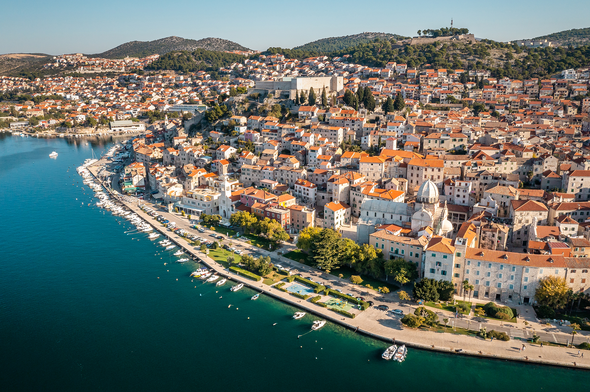
希贝尼克是一座位于克罗地亚亚得里亚海沿岸的历史名城,以其得天独厚的地理位置而闻名——克尔卡河正是在此处汇入大海。这座城市以其保存完好的中世纪老城区、标志性的圣雅各布大教堂(联合国教科文组织世界遗产)以及错落有致的古堡群而著称。
Šibenik ist eine historische Stadt an der kroatischen Adriaküste, die für ihre atemberaubende Lage bekannt ist, wo der Fluss Krka ins Meer mündet. Sie ist berühmt für ihre gut erhaltene mittelalterliche Altstadt, die ikonische Kathedrale des Heiligen Jakob (ein UNESCO-Weltkulturerbe) und ihr Netz aus historischen Festungen.
 Party and government

 Energy resource

 Important port


斯普利特(Split),是一座位于地中海畔、亚得里亚海东岸的克罗地亚南部港市。市内人口约有18万(2001年调查),是达尔马提亚地区最大都市,也是克罗地亚第二大城。同时,斯普利特亦是区内最古老的城市之一,若以古罗马戴克里先宫始建造期(305年)起计算,该市已有1700年历史
Split [ʃplit] (kroatisch Split, italienisch Spalato, entstanden aus griechisch ἀσπάλαθος, aspálathos) ist die zweitgrößte Stadt Kroatiens. Sie ist die größte Stadt Südkroatiens und gilt daher im Volksmund als „Hauptstadt Dalmatiens“, ohne dass ihr dieser Status je offiziell zugesprochen wurde. Die Stadt ist Verwaltungssitz der Gespanschaft Split-Dalmatien (kroatisch Splitsko-dalmatinska županija), die den mittleren Teil Dalmatiens umfasst. Split zählte 2011 etwa 167.000 Einwohner.[2]
Split ist eine bedeutende Hafenstadt und Sitz der katholischen Erzdiözese Split-Makarska. In Split befindet sich zudem eine Universität. Die Ursprünge der Stadt sind auf den Diokletianspalast zurückzuführen. Die Innenstadt von Split mitsamt dem Diokletianspalast wurde 1979 von der UNESCO zum Weltkulturerbe erklärt.
スプリト(クロアチア語: Split、イタリア語: Spalato、ギリシア語: Ασπάλαθος, Aspálathos、ラテン語: Spalatum)は、クロアチア南部スプリト=ダルマチア郡の主都で、ダルマチア最大の都市。アドリア海東海岸の、小さな半島に位置する。
Split (Croatian pronunciation: [splît] ( listen); see other names) is the second-largest city of Croatia and the largest city of the region of Dalmatia, with about 200,000 people living in its urban area. It lies on the eastern shore of the Adriatic Sea and is spread over a central peninsula and its surroundings. An intraregional transport hub and popular tourist destination, the city is linked to the Adriatic islands and the Apennine peninsula.
Home to Diocletian's Palace, built for the Roman emperor in 305 CE, the city was founded as the Greek colony of Aspálathos (Aσπάλαθος) in the 3rd or 2nd century BC. It became a prominent settlement around 650 CE when it succeeded the ancient capital of the Roman province of Dalmatia, Salona. After the Sack of Salona by the Avars and Slavs, the fortified Palace of Diocletian was settled by the Roman refugees. Split became a Byzantine city, to later gradually drift into the sphere of the Republic of Venice and the Kingdom of Croatia, with the Byzantines retaining nominal suzerainty. For much of the High and Late Middle Ages, Split enjoyed autonomy as a free city, caught in the middle of a struggle between Venice and the King of Hungary for control over the Dalmatian cities.
Venice eventually prevailed and during the early modern period Split remained a Venetian city, a heavily fortified outpost surrounded by Ottoman territory. Its hinterland was won from the Ottomans in the Morean War of 1699, and in 1797, as Venice fell to Napoleon, the Treaty of Campo Formio rendered the city to the Habsburg Monarchy. In 1805, the Peace of Pressburg added it to the Napoleonic Kingdom of Italy and in 1806 it was included in the French Empire, becoming part of the Illyrian Provinces in 1809. After being occupied in 1813, it was eventually granted to the Austrian Empire following the Congress of Vienna, where the city remained a part of the Austrian Kingdom of Dalmatia until the fall of Austria-Hungary in 1918 and the formation of Yugoslavia. In World War II, the city was annexed by Italy, then liberated by the Partisans after the Italian capitulation in 1943. It was then re-occupied by Germany, which granted it to its puppet Independent State of Croatia. The city was liberated again by the Partisans in 1944, and was included in the post-war Socialist Yugoslavia, as part of its republic of Croatia. In 1991, Croatia seceded from Yugoslavia amid the Croatian War of Independence.
Split (grec ancien : Ασπάλαθος, Aspálathos, latin : Spalatum, italien : Spalato) est la deuxième ville la plus peuplée de Croatie et le siège du Comitat de Split-Dalmatie. Au recensement de 2011, le comitat comptait 454 798 habitants5, la municipalité 178 102 habitants6, dont 96,23 % de Croates7 et la ville seule comptait 167 121 habitants2.
La ville de Split s'est établie à l'intérieur, puis autour de l'immense palais de l'empereur romain Dioclétien, construit entre 294 et 305, qui s'étendait sur une surface de 39 000 m2. L'empereur était originaire de la ville de Salone (située sur les hauteurs de Split). En 1420, Split fut intégrée dans la République de Venise, jusqu'à sa disparition en 1797. La ville est aujourd'hui inscrite sur la liste du patrimoine mondial par l'UNESCO.
C'est un grand port, industriel et touristique de la côte dalmate.
Spalato (Spàlato; in croato Split; in dalmatico Spalatro; in greco antico Ασπάλαθος, Aspálathos) è una città della Croazia, capoluogo della regione spalatino-dalmata, principale centro della Dalmazia e, con i suoi 178.192 abitanti (2011), seconda città del Paese. Spalato è anche sede universitaria e arcivescovile.
Il nome della città deriva dalla ginestra spinosa, arbusto molto comune nella regione, che in greco antico era denominato Aspálathos (Aσπάλαθος). Sotto l'Impero romano la città si chiamò "Spalatum" e nel Medioevo "Spalatro" in lingua dalmatica. In lingua croata viene denominata "Split" mentre in italiano "Spalato". Nei primi anni del XIX secolo il nome divenne "Spljet" per poi tornare di nuovo alla forma "Split".
Split ( [splît] (?·i), en griego antiguo, Ασπάλαθος, Aspálathos; en latín, Spalatum) es una ciudad situada al sur de Croacia, puerto marítimo de la costa dálmata, en el mar Adriático. Cuenta con 221 456 habitantes, según el censo de 2007.
Es la principal ciudad de la región de Dalmacia, la capital del condado de Split-Dalmacia y la segunda ciudad más populosa del país, después de Zagreb, de la que dista 380 km. Es un importante puerto pesquero y base naval del Adriático, así como un centro cultural y turístico importante; la ciudad antigua es una joya arquitectónica, declarada Patrimonio de la Humanidad en 1979. En su entorno existen astilleros, fábricas de cemento y de plástico, industrias madereras, vitivinícolas y de la alimentación.
 Architecture
 Religion

 Sport


Trogir [ˈtrɔ.ɡiːr] (deutsch und ungarisch Trau, altgriechisch Τραγούριον Tragoúrion, lateinisch Tragurium, italienisch Traù) ist eine Hafenstadt in Kroatien. Sie liegt in Mitteldalmatien, etwa 15 Kilometer westlich von Split. Die gesamte Altstadt zählt seit 1997 zum Weltkulturerbe der UNESCO.
特罗吉尔(克罗地亚语:Trogir,意大利语、达尔马提亚语:Traù,拉丁语:Tragurium,希腊语:Tragurion,匈牙利语:Trau)是克罗地亚的一座古城,亚德里亚海港口,2001年人口 13,322人。特罗吉尔古城座落在克罗地亚大陆和契奥沃岛之间的一个小岛上。位在斯普利特以西27公里。
 Geography
Hand in Hand
Hand in Hand
 Institute of Culture and Language
Croatia
 Literature
Austria
Romania
Serbia
Slovakia
Czech Republic
United States

Die tschechische Sprache (veraltet böhmische Sprache; tschechisch: český jazyk bzw. čeština) gehört zum westslawischen Zweig der indogermanischen Sprachfamilie.
Das Tschechische wird von rund 10,6 Millionen Menschen als Muttersprache gesprochen (Stand: 2016), von denen zirka 10,4 Millionen in Tschechien leben, wo es die Amtssprache ist.[2] Seit dem 1. Mai 2004 ist Tschechisch auch eine Amtssprache der EU. Die Wissenschaft, die sich mit der tschechischen Sprache befasst, ist die Bohemistik.
捷克语(čeština),旧称波希米亚语(拉丁语:lingua Bohemica),属于斯拉夫语族西斯拉夫语支的成员。属同一语支的语言还有斯洛伐克语(相互理解性高)、波兰语(相互理解性较低)、卡舒比语、索布语、西里西亚语等语言。捷克语使用者大多数为捷克共和国居民,少数居住于斯洛伐克的城市。此外,世界各地大约有100万捷克人,其中20至30万人使用捷克语。包括二合字母“ch”在内,捷克语共有42个字母。
捷克语拥有丰富的语态,使得捷克语的语句结构较为自由。捷克语有很多独特的发音,如子音“ř”(发音为/r̝/)、音节响音(syllabic sonorant)l 、m 和 r ,因此有许多看似缺乏母音的词汇,如“zmrzl”、“ztvrdl”、“scvrnkl”、“čtvrthrst”、“Strč prst skrz krk”等。一般情况下,重音在第一音节。