
Deutsch-Chinesische Enzyklopädie, 德汉百科
 Finnland
 Architektur
Belarus
Architektur
Belarus
 Berlin
 Brandenburg
 Bremen
Dänemark
Deutschland
Estland
Finnland
Frankreich
Bremen
Dänemark
Deutschland
Estland
Finnland
Frankreich
 Hamburg
Italien
Lettland
Litauen
Hamburg
Italien
Lettland
Litauen
 Mecklenburg-Vorpommern
Niederlande
Mecklenburg-Vorpommern
Niederlande
 Niedersachsen
 Nordrhein-Westfalen
Polen
Nordrhein-Westfalen
Polen
 Rueckblick
Russland
Rueckblick
Russland
 Sachsen
 Sachsen-Anhalt
 Schleswig-Holstein
Schweden
Schweiz
Schleswig-Holstein
Schweden
Schweiz
 Traditionen
 Urlaub und Reisen
Vereinigtes Königreich
Urlaub und Reisen
Vereinigtes Königreich
 Weltkulturerbe

一种特别在德国北海和波罗的海海岸常见的哥特式建筑是用烤砖建造起来的建筑结构.这个十二世纪开始使用那红色的烤砖作为建筑材料的独特建筑风格之所以在北部德国低地如此普及是因为这块地区缺少天然石而且运输也非常困难,由于那片地区和汉萨盟的一 致性,因此它就成为了汉萨同盟的象征.有些历史悠久的建筑也就成了联合国教科文组织世界文化遗产项目之一。
Die Backsteingotik (englisch Brick Gothic, polnisch Gotyk ceglany) umfasst gotische Bauwerke, die aus oder mit sichtbarem Backstein errichtet wurden. Sie ist vor allem in Norddeutschland, dem Ostseeraum und den Niederlanden[1] verbreitet. Ihr Verbreitungsgebiet erstreckt sich im Westen bis an die Straße von Dover und im Südosten bis nach Galizien. Der auch oft verwendete Begriff Norddeutsche Backsteingotik erfasst daher nur einen Teil der gesamten Backsteingotik. Gotische Backsteinarchitektur in Italien und Südfrankreich wird in der Regel allein den dortigen Regionalstilen zugerechnet.
Die mittelalterliche Verwendung von Backstein als Baustoff setzte nördlich der Alpen im 12. Jahrhundert ein. Die ältesten Bauten gehören deshalb noch der so genannten Backsteinromanik an. Im 16. Jahrhundert ging die Backsteingotik in die Backsteinrenaissance über. Die geografische Verbreitung des Bauens aus Backstein und mit sichtbarem Backstein unterlag vom Beginn des Hochmittelalters bis in die frühe Neuzeit aber durchaus Veränderungen. So gab es in Teilen des Münsterlandes zwischen Pionierbauten der Romanik und dem starken Backsteineinsatz in Renaissance und Barock eine zeitliche Lücke.
Viele von der Backsteingotik geprägte Altstädte und Einzelbauten wurden in die Liste des UNESCO-Welterbes aufgenommen.
Brick Gothic (German: Backsteingotik, Polish: Gotyk ceglany, Dutch: Baksteengotiek) is a specific style of Gothic architecture common in Northwest and Central Europe especially in the regions in and around the Baltic Sea, which do not have resources of standing rock, but in many places a lot of glacial boulders. The buildings are essentially built using bricks. Buildings classified as Brick Gothic (using a strict definition of the architectural style based on the geographic location) are found in Belgium (and the very north of France), Netherlands, Germany, Poland, Lithuania, Latvia, Estonia, Kaliningrad (former East Prussia), Sweden and Finland.
As the use of baked red brick arrived in Northwestern and Central Europe in the 12th century, the oldest such buildings are classified as the Brick Romanesque. In the 16th century, Brick Gothic was superseded by Brick Renaissance architecture.
Brick Gothic is characterised by the lack of figural architectural sculpture, widespread in other styles of Gothic architecture. Typical for the Baltic Sea region is the creative subdivision and structuring of walls, using built ornaments and the colour contrast between red bricks, glazed bricks and white lime plaster. Nevertheless, these characteristics are neither omnipresent nor exclusive. Many of the old town centres dominated by Brick Gothic, as well as some individual structures, have been listed as UNESCO World Heritage sites.
The real extent and the real variety of this brick architecture has to be distinguished from the view of late 19th and early 20th century, especially the years around the end of World War I, when it was instrumentalized, politically.
Indeed, about a quarter of medieval Gothic brick architecture is standing in the Netherlands, in Flanders and in French Flanders. Some dominant buildings combinations of brick and stone. But the criterion "no stone at all" looks like a trick to exclude them.[according to whom?] The towers of St Mary church in Lübeck, the very top Brick Gothic church of the Baltic Sea region, have corners of granite ashley. And many village churches in northern Germany and Poland have Brick Gothic design, but most of their walls are formed by boulders.
L'architettura gotica dei paesi baltici è una varietà regionale dell'architettura gotica, in particolare del gotico tedesco. Le aree coinvolte in questa forma di architettura medievale si affacciano sul mar Baltico e sul Mare del Nord e, da un punto di vista politico, comprendevano gli stati settentrionali del Sacro Romano Impero, le città della Lega Anseatica, i possedimenti dell'Ordine Teutonico. Il periodo interessato va dal XIII secolo al XV secolo.
Le caratteristiche distintive sono che si tratta di un'architettura prevalentemente in laterizio e di una rielaborazione originale e per certi aspetti molto distante dall'iniziale gotico francese. I paesi europei attuali che hanno testimonianze di questa architettura sono Germania, Polonia, Lituania, Lettonia, Estonia, e nell'area della storica Prussia Orientale, (Oblast di Kaliningrad Russia); alcune testimonianze sono anche presenti in Scandinavia.
Le gothique de brique (allemand : Backsteingotik) est un style d´architecture gothique du Nord de l´Europe, et plus particulièrement du Nord de l'Allemagne et des régions autour de la mer Baltique. Il s'est surtout répandu dans les villes culturellement allemandes de l'ancienne Ligue Hanséatique à partir du XIIIe siècle, puis bien au-delà par influence (Scandinavie, Flandres, toute la Pologne, Allemagne du Sud). Les bâtiments sont essentiellement constitués de briques et le style de la décoration s'est adapté aux possibilités et aux limites de ce matériaux, conférant à cette architecture une identité bien particulière.
Il existe d'autres styles d'architecture gothique en brique en Europe, plus ou moins indépendants, comme en Italie et dans la région Toulousaine en France. Le style gothique baltique ne comprend pas tout le gothique en brique d'Europe.
El gótico báltico (en alemán, Norddeutsche Backsteingotik), forma la parte mayor del gótico de ladrillos (en alemán: Backsteingotik). Es una variante de la arquitectura gótica y neogótica que apareció en la Europa septentrional. Sin la especificación "Baltico" es estendido del estrecho de Calais a la Galicia de los Cárpatos. Con la especificación "Baltico" esta concentrada en el norte de Alemania y las zonas aledañas al mar Báltico. En todas estas regiones mancan recursos naturales para construir edificios de piedra. Se extendió principalmente en las ciudades culturalmente alemanas de la antigua Liga Hanseática desde el siglo XIII, y luego por influencia (Escandinavia, toda Polonia, el sur de Alemania). Los edificios son esencialmente de ladrillo y el estilo de decoración se ha adaptado a las posibilidades y límites de este material, dando a esta arquitectura una identidad muy particular.
Кирпичная, ганзейская или северогерманская готика — разновидность готического стиля архитектуры, распространённая в Северной Германии, Польше, Белоруссии и Прибалтике в XIII—XVI веках. Красный керамический кирпич как строительный материал стал использоваться в Северной Европе в XII веке, поэтому самые древние кирпичные образцы относятся ещё к так называемой «кирпичной романике». В XVI в. кирпичную готику сменил «кирпичный ренессанс».
Для кирпичной готики характерны, с одной стороны, отсутствие скульптурных украшений, которые невозможно выполнить из кирпича, и, с другой стороны, богатство орнаментальных деталей кладки и структуризация плоскостей за счёт чередования красного либо глазурованного кирпича и известковой побелки стен.
Многие города, внешний облик которых украшают готические сооружения из красного кирпича, являются объектами Всемирного культурного наследия ЮНЕСКО.
 Automobil

 Europäische Union
Belgien
Deutschland
Estland
Europäische Zentralbank
Europäische Union
Belgien
Deutschland
Estland
Europäische Zentralbank
 Finanz
Finnland
Frankreich
Griechenland
Finanz
Finnland
Frankreich
Griechenland
 Hand in Hand
Irland
Italien
Kroatien
Lettland
Litauen
Luxemburg
Malta
Niederlande
Österreich
Portugal
Slowakei
Slowenien
Spanien
Hand in Hand
Irland
Italien
Kroatien
Lettland
Litauen
Luxemburg
Malta
Niederlande
Österreich
Portugal
Slowakei
Slowenien
Spanien
 Wirtschaft und Handel
Zypern
Wirtschaft und Handel
Zypern

Eurovision Song Contest,ESC
Finnland
 Geographie
Geographie
Geographie
 *Lebenswerteste Städte der Welt
 Internationale Städte
*Kulturhauptstadt Europas
Internationale Städte
*World Design Capital
Olympische Sommerspiele
Internationale Städte
*Kulturhauptstadt Europas
Internationale Städte
*World Design Capital
Olympische Sommerspiele
 Wichtiger Hafen
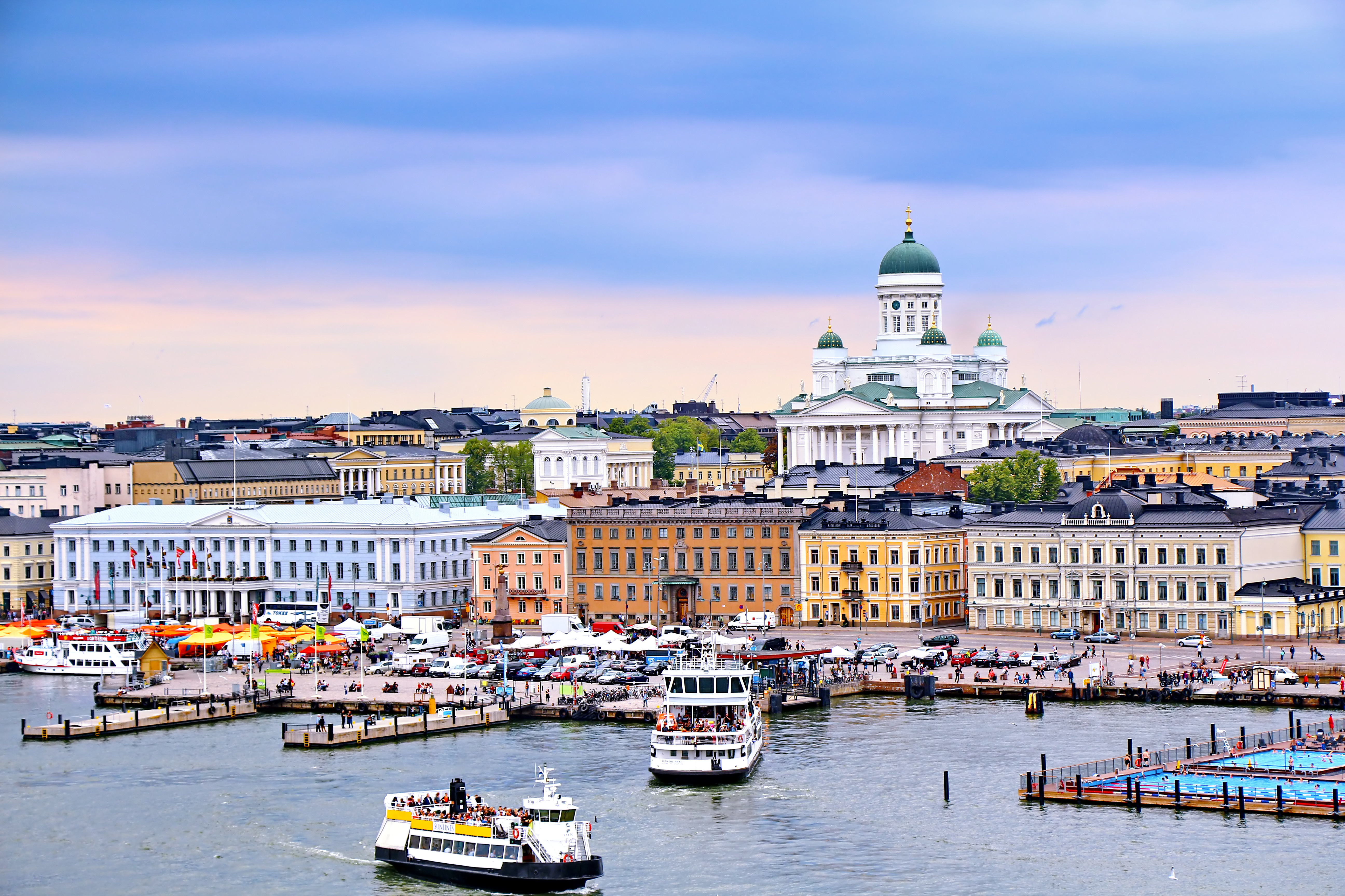
赫尔辛基(芬兰语:Helsinki [ˈhelsiŋki]  聆听;瑞典语:Helsingfors [ˌhɛlsɪŋˈfɔʂː] 聆听),是芬兰的首都以及全国最大城市,芬兰语和瑞典语同为官方语言。赫尔辛基位于新地区,芬兰南端的芬兰湾岸边。在2017年底,赫尔辛基人口为643,272人[4]。所谓“大赫尔辛基”是由赫尔辛基和埃斯波、万塔、考尼艾宁四个城市一起组成的首都地区及周边市镇所组成的都会区,在2014年底的统计中有1,420,284人[5]。
赫尔辛基在爱沙尼亚塔林北部约80公里处,距离西南的瑞典斯德哥尔摩约400公里,距离东边的俄罗斯圣彼得堡约300公里。这三座城市与赫尔辛基在历史上有着密切联系。
Helsinki (finnisch [ˈhɛlsiŋki], schwedisch [hɛlsɪŋˈfɔrs]) ist die Hauptstadt Finnlands. Sie liegt in der Landschaft Uusimaa im Süden des Landes an der Küste des Finnischen Meerbusens und ist die nördlichste Hauptstadt eines Mitgliedstaates der EU. Mit 648.042 Einwohnern (Stand 31. Dezember 2018) ist Helsinki mit Abstand die größte Stadt Finnlands und drittgrößte Stadt der Nordischen Länder, nach Stockholm und Oslo.
Zusammen mit den Nachbarstädten Espoo, Vantaa und Kauniainen bildet es die sogenannte Hauptstadtregion, einen Ballungsraum mit etwa 1,49 Millionen Einwohnern und damit den nördlichsten Ballungsraum der Welt mit über einer Million Einwohnern.[3] Helsinki ist das politische, wirtschaftliche, wissenschaftliche und kulturelle Zentrum Finnlands. Rund sechs Prozent der Einwohner Helsinkis sind schwedischsprachig, offiziell ist die Stadt zweisprachig.
Helsinki liegt 80 km nördlich von Tallinn, Estland, 400 km östlich von Stockholm, Schweden, und 300 km westlich von Sankt Petersburg, Russland. Es hat enge historische Verbindungen zu diesen drei Städten.
Die Stadt wurde, unter dem schwedischen Namen Helsinge fors[4], im Jahr 1550 während der Zugehörigkeit Finnlands zu Schweden gegründet, blieb aber lange unbedeutend. Kurz nachdem Finnland unter russische Herrschaft gekommen war, wurde Helsinki 1812 zur Hauptstadt des neugegründeten Großfürstentums Finnland bestimmt und löste so Turku als wichtigste Stadt des Landes ab. Der offizielle Gebrauch des finnisierten Namens Helsinki begann erst in dieser Zeit.[5]
Seit 1917 ist Helsinki Hauptstadt des unabhängigen Finnlands.
ヘルシンキ (フィンランド語: Helsinki,フィンランド語発音: [ˈhe̞l.siŋ.k̟i])  listen; スウェーデン語: Helsingfors, listen)は、フィンランドの首都で同国最大の都市である。また、バルト海東部のフィンランド湾に面した同国南部のウーシマー県の県庁所在地である。人口は616,042人(2013年2月28日現在)[4]、都市的地域の人口は 1,176,976人(2012年12月31日現在)[5]、ヘルシンキ都市圏である大ヘルシンキの人口は約140万人でフィンランドではもっとも人口の多い自治体と都市域を形成している。
ヘルシンキは、ロシアの旧都サンクトペテルブルク、エストニアの首都タリンと同じく、フィンランド湾に面する主要都市の一つである。ヘルシンキからの距離は、東のサンクトペテルブルクまでは300キロメートル (190 mi)、南のタリンまでは85キロメートル (53 mi)である[6]。 なお、西に400キロメートル (250 mi)の距離に位置するバルト海の対岸のスウェーデンの首都ストックホルムも加え、これらの都市とヘルシンキは歴史的に密接な関係にあった。
ヘルシンキ都市圏には核となるヘルシンキの都市的地域とエスポーやヴァンター、カウニアイネン、周辺のベッドタウンが含まれる[7]。ヘルシンキは100万人以上が住む都市圏としては最北に位置する都市圏で欧州連合加盟国の首都としては最北に位置する都市であり、フィンランドの政治や教育、金融、文化、調査センターなど様々な分野の中心都市で、ヨーロッパでも最北の大都市である。
フィンランドで事業を行う外国企業の70%はヘルシンキ地域で事業を行っており[8]、2009年に、2012年の世界デザイン首都[9]に国際インダストリアルデザイン団体協議会により選ばれ、僅差でアイントホーフェンを破っている。
エコノミスト・インテリジェンス・ユニットは2012年8月に住むのに適した都市の調査で、ヘルシンキは総合で8位にランクした[10]。2011年、モノクルマガジンの調査Liveable Cities Index 2011でヘルシンキは最も住むのに適した都市に位置している[11]。
Helsinki (/ˈhɛlsɪŋki/ HEL-sink-ee or /hɛlˈsɪŋki/ ( listen) hel-SINK-ee;[7][8] Finnish: [ˈhelsiŋki] (listen); Swedish: Helsingfors [hɛlsɪŋˈfɔʂː] (listen), Finland Swedish: [helsiŋˈforsː] (listen)) is the capital, primate and most populous city of Finland. Located on the shore of the Gulf of Finland, it is the seat of the region of Uusimaa in southern Finland, and has a population of 650,058.[9] The city's urban area has a population of 1,268,296,[10] making it by far the most populous urban area in Finland as well as the country's most important center for politics, education, finance, culture, and research; while Tampere in the Pirkanmaa region, located 179 kilometres (111 mi) to the north from Helsinki, is the second largest urban area in Finland. Helsinki is located 80 kilometres (50 mi) north of Tallinn, Estonia, 400 km (250 mi) east of Stockholm, Sweden, and 300 km (190 mi) west of Saint Petersburg, Russia. It has close historical ties with these three cities.
Together with the cities of Espoo, Vantaa, and Kauniainen, and surrounding commuter towns,[11] Helsinki forms the Greater Helsinki metropolitan area, which has a population of nearly 1.5 million. Often considered to be Finland's only metropolis, it is the world's northernmost metro area with over one million people as well as the northernmost capital of an EU member state. After Stockholm and Oslo, Helsinki is the third largest municipality in the Nordic countries. Finnish and Swedish are both official languages. The city is served by the international Helsinki Airport, located in the neighboring city of Vantaa, with frequent service to many destinations in Europe and Asia.
Helsinki was the World Design Capital for 2012,[12] the venue for the 1952 Summer Olympics, and the host of the 52nd Eurovision Song Contest in 2007.
Helsinki has one of the world's highest urban standards of living. In 2011, the British magazine Monocle ranked Helsinki the world's most liveable city in its liveable cities index.[13] In the Economist Intelligence Unit's 2016 liveability survey, Helsinki was ranked ninth among 140 cities.[14]
Helsinki (prononcé /ɛl.siŋ.ˈki/ ; Helsinki /ˈhɛl.siŋ.ki/ Écouter en finnois et Helsingfors /hɛl.sɪŋ.ˈfɔrs/ Écouter en suédois), est la capitale et la plus grande ville de la Finlande avec 642 045 habitants4 dans la commune et 1 456 619 dans le Grand Helsinki. Helsinki est la capitale la plus septentrionale du monde après Reykjavik, capitale de l'Islande. La ville a la plus forte population immigrée de tout le pays. Il y a plus de 130 nationalités résidant dans la ville d'Helsinki. Elle s'étale sur une presqu'île entourée d'un grand nombre d'îles et est fortement caractérisée par la présence de l'eau. Helsinki est un port marchand ouvert sur le golfe de Finlande.
Ses habitants sont appelés les Helsinkiens ; en finnois Helsinkiläiset, en suédois Helsingforsare.
Helsinki (pronuncia italiana [ˈɛlsiŋki][3]; in finlandese [ˈhelsiŋki] ; in svedese , pronuncia [hɛlsɪŋˈfɔrs]) è la capitale e la città più grande della Finlandia, con 648.650 abitanti (dato 2018)[4], situata nella regione dell'Uusimaa. La città è bilingue, le lingue ufficiali sono il finlandese e lo svedese.
Helsinki è geograficamente situata nella parte meridionale del Paese sulle rive del golfo di Finlandia, parte del mar Baltico, di fronte alla capitale dell'Estonia, Tallinn, e si estende su più isole.
L'area metropolitana di Helsinki include l'area urbana della città, Espoo, Vantaa, Kauniainen e paesi limitrofi[5]. È l'area metropolitana più a nord nel mondo, con il suo milione di abitanti è la città e capitale più a nord degli Stati membri dell'Unione europea.
A Helsinki hanno sede il parlamento, il governo, sette università e le sedi dei vescovi evangelico-luterani, cattolici e russo-ortodossi.
Nello slang di Helsinki la città è chiamata Stadi (per il vocabolo svedese stad, "città") o Hesa (forma abbraviata di "Helsinki" con il suffisso gergale -sa), lasciando intendere che chi usa il termine Stadi sia nativo della città[6]. Helsset è il termine usato dai sami del Nord per Helsinki.
Helsinki (en finlandés: Helsinki [ˈhɛlsiŋki] (?·i); en sueco: Helsingfors [hɛlsɪŋˈfɔrs] (?·i)) es la capital y la ciudad más grande de Finlandia. Está situada en la costa sur del país, a la orilla del golfo de Finlandia. Helsinki forma parte de la región de Uusimaa.
Las influencias del Este y el Oeste se encuentran presentes en la vida diaria de Helsinki. Arquitectura, gastronomía, diseño, costumbres y hasta el argot local de las calles atestiguan un pasado bajo dominio ruso y sueco.
Situada junto al mar Báltico, la línea de costa de Helsinki se extiende unos 100 kilómetros, y acoge 300 islas frente al continente. 665 281 personas viven en la propia ciudad de Helsinki (Enero 2020)145 y el área metropolitana (municipios de Helsinki, Espoo, Vantaa y Kauniainen) tiene una población un millón de habitantes en total. Incluyendo otros municipios cercanos la población es de alrededor de 1,4 millones de personas.2 Uno de cada cuatro finlandeses vive en Helsinki.
Helsinki es el mayor centro político, educativo, financiero, cultural y de investigación, así como una de las ciudades más importantes del norte de Europa. Aproximadamente el 70 % de las empresas extranjeras que operan en Finlandia se han establecido en la región de Helsinki.6
Helsinki fue elegida Capital Mundial del Diseño para el año 2012,7 sede de los Juegos Olímpicos en 1952 y del 52º Festival de Eurovisión en 2007. Helsinki es conocida a nivel mundial por su gran diseño, el cual es bien evidente en sus calles, comercios y edificios, formando parte de la red de ciudades creativas por la UNESCO desde 2014.8
En la edición de agosto de 2012, el estudio del Economist Intelligence Unit colocó en octavo lugar a Helsinki en el ranking general de las mejores ciudades para vivir a nivel mundial.9 En 2011 la revista Monocle estableció a la ciudad de Helsinki como la mejor ciudad para vivir y desarrollarse en el mundo entero.
Хе́льсинки (фин. Helsinki, швед. Helsingfors , до 1926 года в русском языке официально использовалось шведское название Гельсингфорс[3]) — столица и крупнейший город Финляндии, административный центр провинции Уусимаа (Нюланд). Расположен на юге страны, на берегу Финского залива Балтийского моря. Население — 655 281 человека (31.1.2020)[4]. Иностранные граждане составляют около 10 % населения города.
Хельсинки вместе с городами-спутниками Вантаа (Ванда), Эспоо (Эсбy[5]) и Кауниайнен (Гранкулла) образует столичный регион с населением более миллиона человек. Население Большого Хельсинки, территория которого включает 12 коммун, превышает 1,3 миллиона человек[2]. Хельсинки является центром бизнеса, образования, культуры и науки в Финляндии. В Большом Хельсинки расположены 8 университетов и 6 технологических парков[6]. 70 % иностранных компаний, работающих в Финляндии, расположены в столичном регионе[6]. Миграция населения из провинции делает Хельсинки одним из самых быстрорастущих муниципальных районов в Европе. Главным международным авиаузлом в Финляндии является Аэропорт Хельсинки-Вантаа, расположенный в 20 километрах от центра столицы и осуществляющий прямые перелёты по всему миру. Путь от Хельсинки до Таллина занимает 1,5 часа по морю и 18 минут на вертолёте (расстояние составляет 80 км). В два других крупных города, Тампере и Турку, можно попасть за 1,5—2 часа на поезде и 1,5—2,5 часа на машине. На скоростном поезде «Аллегро» до Санкт-Петербурга можно добраться за 3,5 часа (390 км).
В 2014 году в рейтинге 25 лучших городов мира, составленном британским журналом Monocle[en], Хельсинки занял пятое место (на первом месте — Копенгаген)[7]. В 2011 году в опубликованном международной консалтинговой компанией Mercer рейтинге наиболее безопасных городов мира Хельсинки разделил 2—4 места с Цюрихом и Берном (на первом месте — Люксембург)[8][9]. В начале 2012 года газета The New York Times в ежегодно публикуемом ею списке мест нашей планеты, которые стоит посетить в наступившем году, поставила Хельсинки на второе место (на первом месте — Панама, на третьем — Мьянма)[10][11].
По опросам общественного мнения в 2012 году Хельсинки занимает четвёртое место по уровню привлекательности для проживания среди финских граждан[12].
В 2013 году по расчетам консалтингового агентства ECA International Хельсинки занял двадцатое место в рейтинге самых дорогих городов планеты (первое место — Осло)[13], а международная деловая газета Financial Times представила ряд районов финской столицы в лучшем свете как мест для вложений в недвижимость[14].
День города отмечается ежегодно 12 июня[15].
 Transport und Verkehr
Airbus A320
A319-100
Airbus A320
A320-100 / -200
Airbus A320
A321-100 / -200
Airbus A330
A330-300
Airbus A350
A350-900
ATR
72-500
Embraer E-Jet family
E190
Finnair
Finnland
Transport und Verkehr
Airbus A320
A319-100
Airbus A320
A320-100 / -200
Airbus A320
A321-100 / -200
Airbus A330
A330-300
Airbus A350
A350-900
ATR
72-500
Embraer E-Jet family
E190
Finnair
Finnland
 Luft- und Raumfahrt
Oneworld
Luft- und Raumfahrt
Oneworld
 Unternehmen
 Bernsteinstraße
Dänemark
Deutschland
Estland
Finnland
Geographie
Lettland
Litauen
Mecklenburg-Vorpommern
Nord-Ostsee-Kanal
Polen
Russland
Schleswig-Holstein
Schweden
Bernsteinstraße
Dänemark
Deutschland
Estland
Finnland
Geographie
Lettland
Litauen
Mecklenburg-Vorpommern
Nord-Ostsee-Kanal
Polen
Russland
Schleswig-Holstein
Schweden
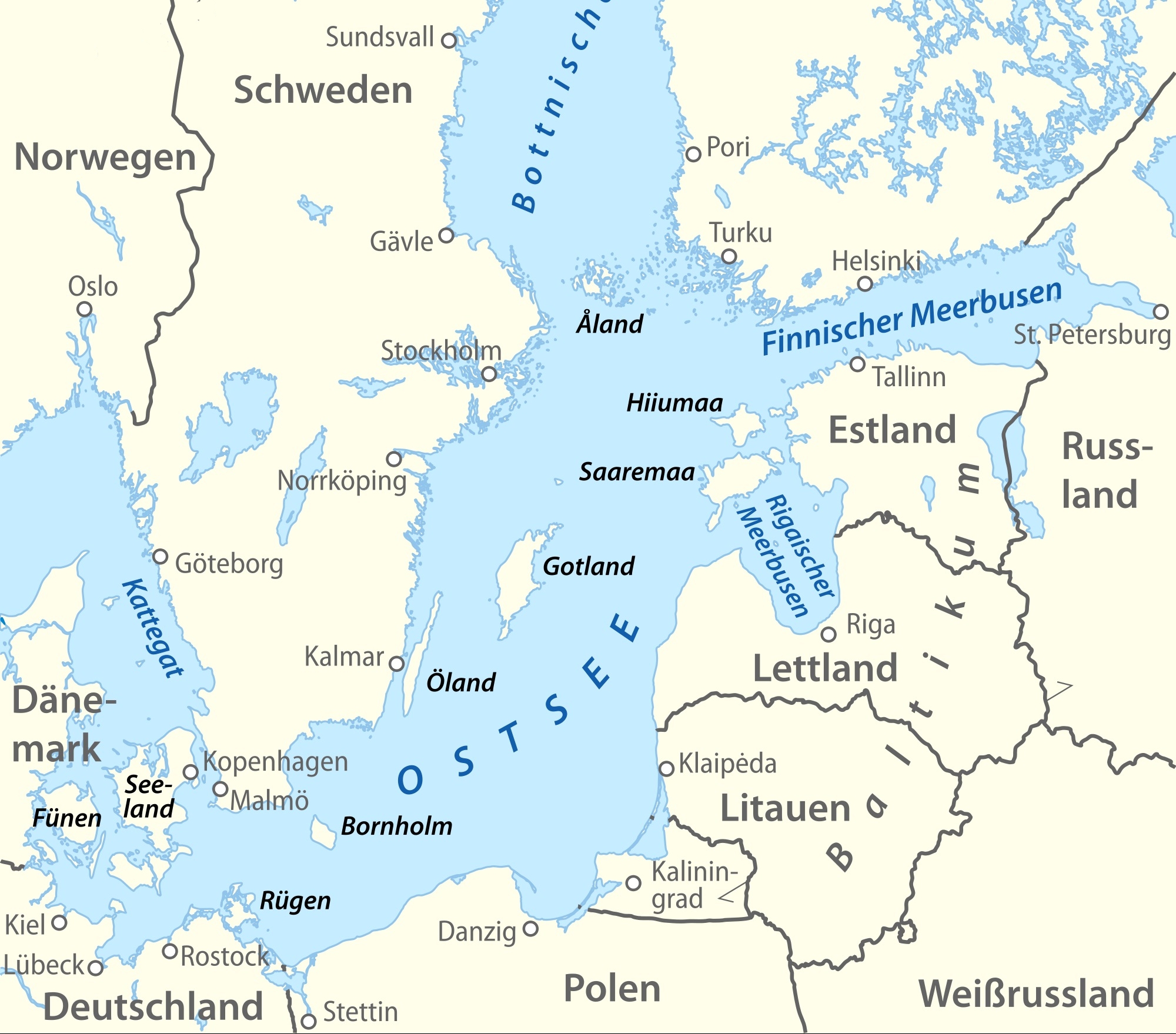
波罗的海是中欧和北欧之间的陆间海,海域横贯北纬53度至北纬66度,东经10度至东经30度,介于斯堪的纳维亚半岛的瑞典部分、欧洲大陆和丹麦诸岛之间。
波罗的海由厄勒海峡、大贝尔特海峡和小贝尔特海峡注入卡特加特海峡,而后者则通过斯卡格拉克海峡注入北海,最后进入大西洋;此外它还通过白海运河同白海相连,通过基尔运河同北海相连。
波罗的海在北端与波的尼亚湾相邻,在东北端与芬兰湾相邻,在东端与里加湾相邻。这些海湾同样可以被看作是波罗的海的一部分。
Die Ostsee (auch Baltisches Meer, von lat. Mare Balticum, oder auch Baltische See genannt) ist ein 412.500 km²[2] großes und bis zu 459 m tiefes Binnenmeer in Europa und gilt als das größte Brackwassermeer der Erde, auch wenn in der westlichen Ostsee aufgrund des Wasseraustausches mit der Nordsee zumeist ein höherer Salz- und Sauerstoffgehalt beobachtet werden kann. Der Rauminhalt des Meeres beträgt rund 20.000 km³. Im Ostseeraum leben, je nachdem, wie weit man diese Region eingrenzt, zwischen 50 und 85 Millionen Menschen.[3]
バルト海(バルトかい、Baltic Sea)は、北ヨーロッパに位置する地中海。ヨーロッパ大陸とスカンディナビア半島に囲まれた海域である。ユーラシア大陸に囲まれた海域と説明されることもある[1]。
西岸にスウェーデン、東岸は、北から順にフィンランド、ロシア、エストニア、ラトビア、リトアニア、南岸は、東から西にポーランド、ドイツ、デンマークが位置する。
The Baltic Sea is a marginal sea of the Atlantic Ocean, enclosed by Finland, Sweden, Denmark, Estonia, Latvia, Lithuania, Russia, Poland, Germany and the North and Central European Plain.
The sea stretches from 53°N to 66°N latitude and from 10°E to 30°E longitude. A mediterranean sea of the Atlantic, with limited water exchange between the two bodies, the Baltic Sea drains through the Danish islands into the Kattegat by way of the straits of Øresund, the Great Belt, and the Little Belt. It includes the Gulf of Bothnia, the Bay of Bothnia, the Gulf of Finland, the Gulf of Riga, and the Bay of Gdańsk.
The Baltic Proper is bordered on its northern edge, at the latitude 60°N, by the Åland islands and the Gulf of Bothnia, on its northeastern edge by the Gulf of Finland, on its eastern edge by the Gulf of Riga, and in the west by the Swedish part of the southern Scandinavian Peninsula.
The Baltic Sea is connected by artificial waterways to the White Sea via the White Sea Canal and to the German Bight of the North Sea via the Kiel Canal.
La mer Baltique est une mer intracontinentale et intérieure de 364 800 km2 située dans le Nord de l'Europe et reliée à l'océan Atlantique par la mer du Nord. Elle communique au sud-ouest avec la mer du Nord par le Cattégat et le Skagerrak. Trois golfes principaux intègrent cet espace : le golfe de Botnie au nord, le golfe de Finlande à l'est et le golfe de Riga au sud-est.
Les pays riverains sont :
- la Suède à l'ouest et au nord ;
- la Finlande au nord-est ;
- la Russie (par le golfe de Finlande) et l'Estonie à l'est ;
- la Lettonie au sud-est ;
- la Lituanie, la Russie (à Kaliningrad) et la Pologne au sud;
- l'Allemagne et le Danemark au sud-ouest.
Ces pays riverains, ainsi que la mer proprement dite, font l'objet, depuis 2009, d'une « stratégie de la Commission européenne en faveur du développement de la région de la mer Baltique »1, incluant un effort de dépollution de la Baltique et un système commun de surveillance maritime.
Il mar Baltico è un mare interno dell'oceano Atlantico settentrionale e si trova nell'Europa nord-orientale, circondato dalla Penisola scandinàva (meno correttamente scandìnava)[1], dalla terraferma dell'Europa centrale e orientale e dalle Isole danesi. Sfocia nel Kattegat e nel mare del Nord passando attraverso le isole danesi in tre stretti, l'Øresund, il Piccolo Belt e il Grande Belt.
Sfociano nel mar Baltico cinque grandi fiumi: l'Oder, la Vistola, il Njemen, la Daugava (o Dvina Occidentale) e la Neva. Le coste del Baltico tendono a ghiacciare d'inverno specie in occasione di eventi meteorologici particolarmente freddi.
Viene indicato come "mare dell'Est" in diverse lingue dell'Europa continentale, precisamente in danese (Østersøen), tedesco (Ostsee), finlandese (Itämeri), olandese (Oostzee), norvegese (Østersjøen), e svedese (Östersjön). In estone viene invece chiamato "mare Occidentale" (Läänemeri). Oltre all'italiano, viene chiamato mar Baltico in francese (mer Baltique), inglese (Baltic Sea), polacco (Morze Bałtyckie), russo (Baltijskoe more, Балтийское море), lituano (Baltijos Jūra), lettone (Baltijas Jūra) e greco (Baltiké thálassa, Βαλτική Θάλασσα).
El mar Báltico (del latín: Mare Balticum) es un mar interior de agua salobre del norte de Europa abierto al mar del Norte y, finalmente, al océano Atlántico a través de los estrechos de Kattegat y Skagerrak. Los países que lo rodean son (empezando por la península Escandinava y siguiendo en sentido horario): Suecia, Finlandia, Rusia (óblast de Leningrado y Kaliningrado), Estonia, Letonia, Lituania, Polonia, Alemania y Dinamarca.
Su superficie es de 432 800 km² e incluye dos grandes golfos: el golfo de Finlandia, entre el sur de este país y Estonia, y el golfo de Botnia, entre la costa oriental de Suecia y el occidental de Finlandia. Geológicamente es muy joven: sólo existe desde el VI milenio a.C. Es muy poco profundo (la media es de 57 m; la profundidad máxima es de 459 m al norte de la isla sueca de Gotland), lo que, unida a la poca apertura al océano, hace la renovación de las aguas muy lenta y favorece los problemas de contaminación. Las mareas son de muy pequeña amplitud.
El mar Báltico es también, el mayor depósito de ámbar del mundo y, además, su calidad es de las mejores: de los veinte depósitos del mundo que hay de ámbar, se dice que el del mar báltico sólo es superado por los de México y la República Dominicana, siendo el que más ámbar de conífera produce y el de mejor calidad. De él se extraen de 500 a 800 millones de toneladas de ámbar.
La cuenca que drena al mar Báltico abarca la totalidad de algunos países ribereños como las repúblicas bálticas, Polonia y la región rusa de Kaliningrado. Además, estos ríos nacen en, o atraviesan territorios pertenecientes a otros países que, a pesar de no poseer costas, se comunican al mar por vía fluvial. Tal es el caso de la República Checa, Eslovaquia, Ucrania y Bielorrusia, quienes acaban aportando agua (indirectamente) al mar Báltico.
Балти́йское мо́ре (Варяжское[1], польск. Morze Bałtyckie, нем. Ostsee, н.-нем. Oostsee, швед. Östersjön, дат. Østersøen, фин. Itämeri, эст. Läänemeri, латыш. Baltijas jūra, лит. Baltijos jūra) — внутриматериковое море Евразии, расположенное в Северной Европе (частично омывает также берега Западной и Восточной Европы). Относится к бассейну Атлантического океана.
Крайняя северная точка Балтийского моря находится вблизи Северного полярного круга (65°40' с. ш.), крайняя южная — около города Висмара (53°45' с. ш.).
Крайняя западная точка расположена в районе Фленсбурга (9°10' в. д.), крайняя восточная — в районе Санкт-Петербурга (30°15' в. д.)
Площадь поверхности моря (без островов) — 415 тыс. км². Объём воды — 21,5 тыс. км³. Из-за огромного стока рек вода имеет низкую солёность и потому море является солоноватоводным. Является крупнейшим в мире морем с такой особенностью[2].
Участок континентальной коры, на котором лежит современное Балтийское море, является частью устойчивой Русской тектонической плиты (Фенносарматия). Как единый массив он сложился около 1,8 миллиарда лет назад и с тех пор пребывал в относительной стабильности. Бо́льшая часть территории, соответствующей дну современной Балтики, бо́льшую часть времени находилась выше уровня моря, хотя южная и восточная части этого пространства продолжительное время были покрыты мелководными шельфовыми морями, о чём свидетельствует мощный слой донных осадков в этих областях. Балтийский кратон образовался в южном полушарии, дрейфовал на запад, находясь в эдиакарии в районе Южного Полярного круга, а далее на север, пересёк экватор около 375 млн л. н., и около 30 миллионов лет назад уже приблизился к современному положению. В разное время он был составной частью различных материков (Нуна, Нена, Родиния, Протолавразия, Паннотия, Лавруссия, Пангея, Лавразия, Евразия), а некоторое время также отдельным материком Балтикой.
Примерно 40 миллионов лет назад, когда контуры северной, центральной и восточной Европы уже сложились на близких к современным широтах, на месте будущего Балтийского моря возникла долина реки Эридан, протекавшей в юго-западном направлении параллельно Скандинавским горам — то есть приблизительно так же, как будет расположено Балтийское море: исток брала в Лапландии, а сильно ветвистая дельта в районе современных Нидерландов впадала в древнее Северное море, и в области нынешнего Финского залива располагался крупный приток. С наступлением четвертичного оледенения, примерно 700 тыс. л. н. Эридан прекратил существование, поскольку его долина, как и вся северная Европа, скрылась под ледниковым щитом. По берегам Эридана росла тайга. После образования ледника смола хвойных деревьев превратилась в янтарь.
ности и другие параметры Литоринового моря стали близки к современным — начинается около 4 тысяч лет назад. Примерно в это же время возникает и Нева.
AI-Ran-Allianz
Finnland

 IT-Times
Games-Industrie
IT-Times
Spätklassik, Romantik (Früh, Mittel, Spät)
IT-Times
Artificial Intelligence
IT-Times
Games-Industrie
IT-Times
Spätklassik, Romantik (Früh, Mittel, Spät)
IT-Times
Artificial Intelligence
 Leben und Style
Unternehmen
*Jahrhundertealte Unternehmen der Welt
Leben und Style
Unternehmen
*Jahrhundertealte Unternehmen der Welt
 Wissenschaft und Technik
Global Innovators
Wissenschaft und Technik
Global Innovators

Nokia Oyj [ˈnɔkiɑ] bzw. Nokia Corporation ist ein Telekommunikationskonzern mit Hauptsitz im finnischen Espoo, der weltweit Mobile-, Festnetz- und Cloud-Netzwerklösungen anbietet.
 Projekt und Baumaschinen

 Astronomie
Belgien
Brasilien
Dänemark
Deutschland
European Southern Observatory
Finnland
Frankreich
Italien
Luft- und Raumfahrt
Niederlande
Österreich
Portugal
Schweden
Schweiz
Spanien
Tschechien
Vereinigtes Königreich
Wissenschaft und Technik
Astronomie
Belgien
Brasilien
Dänemark
Deutschland
European Southern Observatory
Finnland
Frankreich
Italien
Luft- und Raumfahrt
Niederlande
Österreich
Portugal
Schweden
Schweiz
Spanien
Tschechien
Vereinigtes Königreich
Wissenschaft und Technik
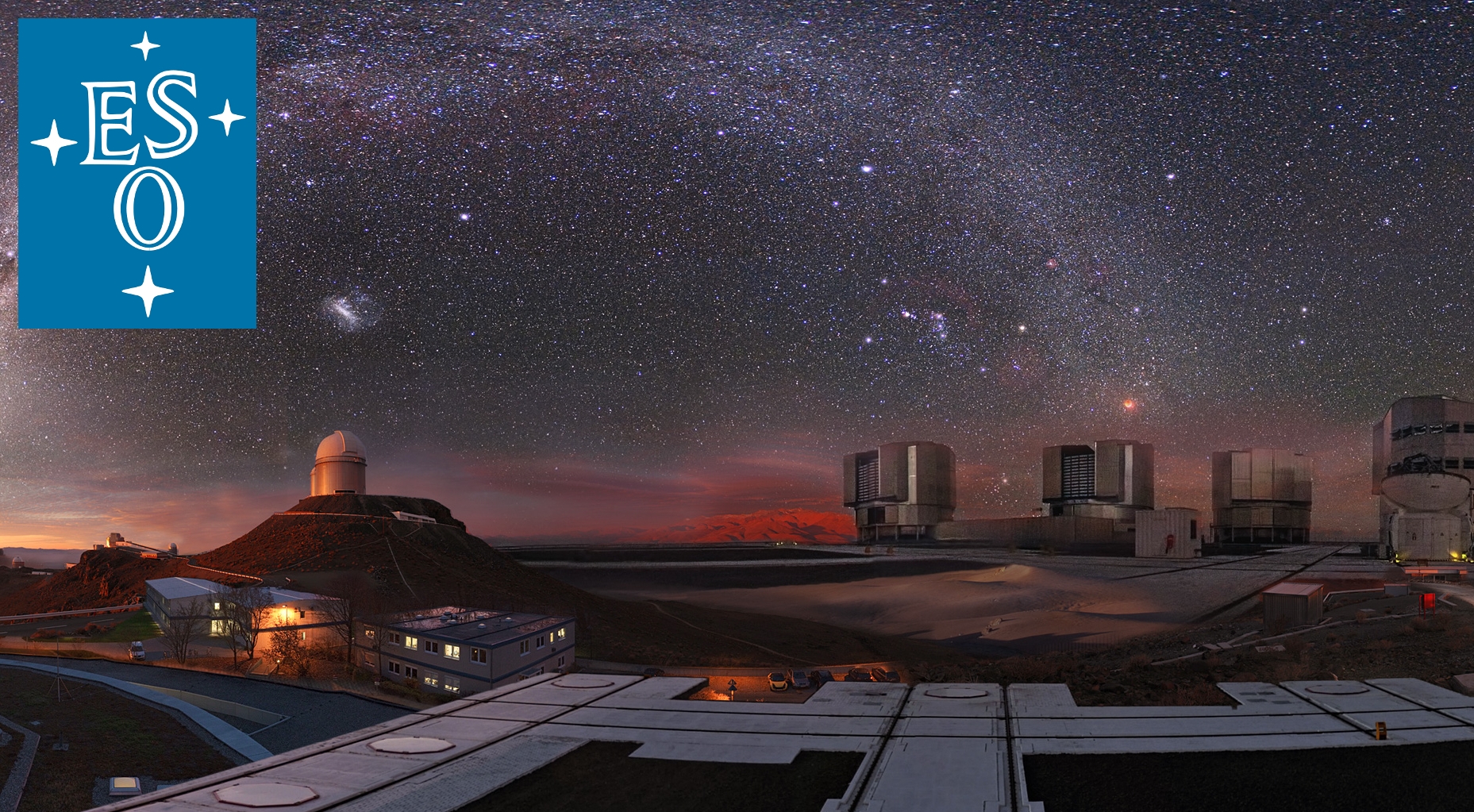
欧洲南方天文台 (The European Southern Observatory,ESO) 是为在南半球研究天文学,在政府间组织的一个研究机构,由15个国家组成和支援的一个天文研究组织。它成立于1962年,目的是为欧洲的天文学家提供先进的设施和捷径以研究南方的天空。这个组织的总部设在德国慕尼黑附近的加兴,雇用了约700名工作人员,每年并接受成员国约135亿欧元的经费[1]。
欧洲南方天文台建设和经营一些已知规模最大和技术最先进的望远镜,包括首创主动光学技术的新技术望远镜、和由4个8米等级的望远镜和4个1.8米辅助望远镜组成的甚大望远镜。目前由ESO进行的计划包括亚他加马大型毫米波阵列和欧洲极大望远镜。
ALMA是下一个十年最大的地面天文专案,将成为在毫米与次毫米波尺度下观测的主要新工具。他的建设正在进行中,预计于2013年完成。ALMA专案是欧洲各国、亚洲、北美洲和智利之间的国际合作计划。欧洲的执行权由ESO代表行使,并且还主持ALMA区域中心[2]。
E-ELT是40米等级的望远镜,目前还在细部设计阶段,将是世界上观测天空最大的巨眼。 欧洲极大望远镜,它将极有力的推动天文物理学的知识,能够仔细研究的天体,包括围绕着其它恒星的行星、宇宙中的第一个天体、超大质量黑洞、和主宰宇宙的暗 物质与暗能量的自然本质和分布。从2005年底,ESO就一直与工作和使用社群的欧洲天文学家和天文物理学家共同来定义此新的聚型望远镜[3]。
ESO的观测机构已经作出许多重大的天文发现和一些天体目录[4]。最近的研究结果包括发现最遥远的伽玛射线暴和我们的星系,银河系,中心有黑洞的证据。在2004年,甚大望远镜让天文学家获得第一张在173光年外环绕着的棕矮星的系外行星2M1207b轨道的绝佳影像。安装在ESO另一架望远镜上的仪器,高精度径向速度行星搜索器发现许多的系外行星,包括迄今发现最小的系外行星格利泽581c。甚大望远镜还发现了迄今距离人类最遥远星系的候选者阿贝尔1835 IR1916。
Die Europäische Organisation für astronomische Forschung in der südlichen Hemisphäre (englisch European Organisation for Astronomical Research in the Southern Hemisphere) oder in der Kurzform Europäische Südsternwarte (engl. European Southern Observatory, ESO) ist ein europäisches Forschungsinstitut, das Teleskope in Chile betreibt.
Die vielen Beobachtungseinrichtungen der ESO verhalfen der Astronomie zu zahlreichen Entdeckungen und produzierten einige astronomische Kataloge.
Unter anderen wurden an ESO-Observatorien der bis heute am weitesten entfernte Gammablitz beobachtet sowie Beweise für die Existenz eines Schwarzen Lochs im Zentrum unserer Milchstraße gefunden.
Die Zunahme der Expansionsgeschwindigkeit des Universums konnte basierend auf Beobachtungen weit entfernter Supernovae mit den Teleskopen auf La Silla gezeigt werden.[2]
Das Very Large Telescope (VLT, deutsch sehr großes Teleskop) konnte zum ersten Mal Kohlenmonoxid-Moleküle in einer Galaxie in einer Entfernung von etwa elf Milliarden Lichtjahren analysieren. Dies ermöglichte die Erlangung der präzisesten Messergebnisse der Temperatur für eine derart entfernte Epoche.[3]
Ebenso mit dem VLT konnten Astronomen das größte gemessene Alter eines Sterns in unserer Milchstraße bestimmen. Mit seinen 13,2 Milliarden Jahren wurde der Stern in einer der frühesten Phasen der Sternentstehung im Universum geboren.[4]
2004 konnte mit Hilfe des VLT das erste Bild eines extrasolaren Planeten (2M1207 b) aufgenommen werden. Seither konnten mit dem Spektrografen HARPS viele weitere extrasolare Planeten aufgespürt werden.
Nach in Summe über 1000 Beobachtungsnächten auf La Silla, die sich über 15 Jahre hin erstreckten, konnten die Bewegungsmuster von mehr als 14.000 sonnenähnlichen Sternen in Nachbarschaft der Sonne bestimmt werden. Es konnte somit gezeigt werden, dass unsere Heimatgalaxie ein turbulenteres und chaotischeres Leben durchmachte als zuvor angenommen wurde.[5]
ヨーロッパ南天天文台(ヨーロッパなんてんてんもんだい、European Southern Observatory、略称:ESO)は、ヨーロッパ14ヶ国およびブラジルが共同で運営する天文観測施設である。1964年に設立された。チリにある天文台を運営している。本部はミュンヘン近郊のGarchingにある。ラ・シヤ天文台(La Silla Observatory)、パラナル天文台(Paranal Observatory)、チャナントール天文台(Llano de Chajnantor Observatory)がおもな施設である。
The European Southern Observatory (ESO), formally the European Organisation for Astronomical Research in the Southern Hemisphere[2], is a 16-nation intergovernmental research organization for ground-based astronomy. Created in 1962, ESO has provided astronomers with state-of-the-art research facilities and access to the southern sky. The organisation employs about 730 staff members and receives annual member state contributions of approximately €162 million.[3] Its observatories are located in northern Chile.
ESO has built and operated some of the largest and most technologically advanced telescopes. These include the 3.6 m New Technology Telescope, an early pioneer in the use of active optics, and the Very Large Telescope (VLT), which consists of four individual 8.2 m telescopes and four smaller auxiliary telescopes which can all work together or separately. The Atacama Large Millimeter Array observes the universe in the millimetre and submillimetre wavelength ranges, and is the world's largest ground-based astronomy project to date. It was completed in March 2013 in an international collaboration by Europe (represented by ESO), North America, East Asia and Chile.[4][5]
Currently under construction is the Extremely Large Telescope. It will use a 39.3-metre-diameter segmented mirror, and become the world's largest optical reflecting telescope when operational in 2024. Its light-gathering power will allow detailed studies of planets around other stars, the first objects in the universe, supermassive black holes, and the nature and distribution of the dark matter and dark energy which dominate the universe.
ESO's observing facilities have made astronomical discoveries and produced several astronomical catalogues.[6] Its findings include the discovery of the most distant gamma-ray burst and evidence for a black hole at the centre of the Milky Way.[7][8] In 2004, the VLT allowed astronomers to obtain the first picture of an extrasolar planet (2M1207b) orbiting a brown dwarf 173 light-years away.[9] The High Accuracy Radial Velocity Planet Searcher (HARPS) instrument installed on the older ESO 3.6 m telescope led to the discovery of extrasolar planets, including Gliese 581c—one of the smallest planets seen outside the solar system.[10]
L’Observatoire européen austral (en anglais, European Southern Observatory : ESO), officiellement nommé l'Organisation européenne pour des observations astronomiques dans l’hémisphère austral1 (European Organisation for Astronomical Research in the Southern Hemisphere), est une organisation intergouvernementale pour l’astronomie fondée en 1962 par cinq pays européens, afin de créer un observatoire astronomique de pointe au sol dans l'hémisphère austral à disposition des astronomes.
L'ESO est l'acteur principal de l'astronomie observationnelle européenne. Il possède des télescopes allant de 2,2 à 8,20 mètres de diamètre, un parc d'une vingtaine d'instruments, dont 15 à Paranal, permettant des observations en imagerie, photométrie, spectroscopie, interférométrie dans à peu près toutes les longueurs d'onde allant du proche ultraviolet à l'infrarouge thermique (vers 20 microns). L'organisation possède également un système complet d'archivage des données, en partenariat avec l'agence de coordination entre l'Europe et le télescope spatial Hubble.
Son siège se trouve à Garching bei München près de Munich en Allemagne ; il dispose de bureaux au Chili à Vitacura dans la capitale Santiago du Chili. En 2018, l'organisation compte 16 états membres et trois sites d'observations, tous au Chili : l'Observatoire de La Silla, l'Observatoire du Cerro Paranal, où se trouve le Very Large Telescope, et l'Observatoire du Llano de Chajnantor.
L’Osservatorio Europeo Australe (ESO, dall'inglese European Southern Observatory, formalmente Organizzazione europea per la ricerca astronomica nell'emisfero australe) è un'organizzazione astronomica internazionale, di cui a settembre 2018 fanno parte sedici nazioni.[1] Creata nel 1962, l'ESO fornisce agli astronomi strumenti all'avanguardia e un accesso al cielo australe. L'organizzazione impiega circa 730 persone e riceve contributi annui di circa 143 milioni di Euro da parte degli Stati membri.[2]
ESO ha costruito e gestito alcuni dei più grandi e più avanzati telescopi del mondo, come il New Technology Telescope (NTT), il telescopio che lanciò la tecnologia dell'ottica attiva e il VLT (Very Large Telescope), composto da quattro telescopi principali (UT) con specchi primari di 8,2 metri di diametro e quattro telescopi ausiliari mobili (in inglese, Auxiliary Telescope, AT) di 1,8 metri di diametro. Ultimo progetto sviluppato da ESO è l'Atacama Large Millimeter Array (ALMA), mentre in fase di sviluppo si trova l'European Extremely Large Telescope (E-ELT).
Atacama Large Millimeter Array (ALMA) è un osservatorio rivoluzionario per l'osservazione dell'universo nelle radiazioni millimetriche/submillimetriche ed è attualmente il più grande progetto astronomico da terra. La sua costruzione è stata completata nel 2013. Il progetto ALMA è una collaborazione internazionale tra l'Europa (rappresentata da ESO), il sud est asiatico, l'America del Nord e la Repubblica del Cile.[3][4]
Uno dei più ambiziosi progetti di ESO è l'E-ELT (che sta per European Extremely Large Telescope), un telescopio di 39 metri di diametro, basato su un design innovativo con 5 specchi. Una volta costruito l'E-ELT sarà il più grande telescopio ottico/infrarosso al mondo. ESO ha cominciato la fase di design di questo telescopio all'inizio del 2006, con lo scopo di essere pronti a costruirlo nel 2014.[5] L'E-ELT dovrebbe essere pronto nel 2025. La grande capacità di accumulare la luce dell'E-ELT permetterà studi dettagliati di pianeti attorno ad altre stelle, dei primi oggetti dell'universo, di buchi neri supermassicci e della natura e della distribuzione della materia e dell'energia oscura che dominano l'universo.
I numerosi strumenti di osservazione di ESO hanno permesso molte scoperte astronomiche e prodotto diversi cataloghi astronomici.[6] Tra le più recenti scoperte: il più distante lampo gamma e il buco nero al centro della nostra galassia, la Via Lattea.[7][8] Nel 2004 il VLT ha dato agli astronomi la possibilità di ottenere la prima foto di un pianeta extra-solare, 2M1207b, che orbita attorno ad una nana bruna distante 173 anni-luce.[9] Lo spettrografo HARPS ha permesso la scoperta di molti altri pianeti extra-solari, incluso un pianeta 5 volte più pesante della Terra che orbita attorno ad una nana rossa, chiamato Gliese 581c.[10] Il VLT ha anche scoperto la galassia più lontana mai vista dall'uomo, Abell 1835 IR1916.
La Organización Europea para la Investigación Astronómica en el Hemisferio Austral (en inglés European Organisation for Astronomical Research in the Southern Hemisphere o European Southern Observatory), más conocida como el Observatorio Europeo Austral o Del Sur es una organización astronómica intergubernamental creada en el año 1962, dedicada a la astrofísica y al desarrollo y operación de telescopios en la Zona Norte de Chile.
Sus oficinas centrales están en Garching, cerca de Múnich, Alemania, y además cuenta con una oficina en Santiago, Chile.
Uno de los proyectos más destacados del ESO es el Telescopio Europeo Extremadamente Grande, la propuesta para la nueva generación de telescopios ópticos terrestres.
Европейская южная обсерватория, (англ. ESO, European Southern Observatory, официальное название — Европейская организация астрономических исследований в Южном полушарии) — международная исследовательская организация, членами которой являются 15 европейских государств и Бразилия.
Идея создания объединённой европейской обсерватории появилась в Лейденской обсерватории в Нидерландах весной 1953 года у Вальтера Бааде и Яна Оорта. 21 июня того же года Оорт собрал группу астрономов в Лейдене, чтобы обсудить возможность её создания. Позднее этот вопрос был поднят на Гронингской конференции, также проводившейся в Нидерландах. 26 января 1954 года декларация ESO была подписана ведущими астрономами шести европейских стран за создание совместной европейской обсерватории в южном полушарии.[1]
Выбор южного полушария был обоснован тем, что все крупные рефлекторные телескопы на тот момент находились в северном полушарии. Кроме того, многие объекты, такие как центральная часть Млечного Пути и Магеллановы облака, доступны только из южного полушария. Изначально планировалось, что телескопы будут располагаться в Южной Африке, однако в ходе наблюдений выяснилось, что условия в Южных Андах более предпочтительны, и 15 ноября 1963 года местом расположения обсерватории была выбрана Республика Чили.[2]
До принятия этого решения 5 октября 1962 года Бельгией, Германией, Францией, Нидерландами и Швецией была подписана Конвенция ESO, а на должность генерального директора был назначен Отто Хекман.
Первые телескопы ESO, расположенные в Ла-Силье, начали работать в 1966 году.[1] В 1980 году штаб-квартира европейского департамента ESO была перенесена в Гархинг под Мюнхеном, Германия.
 Fahrschule
Ägypten
Australien
Belgien
Brasilien
Dänemark
Deutschland
Finnland
Frankreich
Griechenland
Hand in Hand
Hand in Hand
Führerschein
Indien
Indonesien
Italien
Japan
Kanada
Kasachstan
Kroatien
Malaysia
Mexiko
Fahrschule
Ägypten
Australien
Belgien
Brasilien
Dänemark
Deutschland
Finnland
Frankreich
Griechenland
Hand in Hand
Hand in Hand
Führerschein
Indien
Indonesien
Italien
Japan
Kanada
Kasachstan
Kroatien
Malaysia
Mexiko
 Mongolei
Neuseeland
Niederlande
NuetzlicheInfo
Österreich
Portugal
Republik Korea
Russland
Saudi-Arabien
Schweden
Schweiz
Singapur
Spanien
Südafrika
Thailand
Tschechien
Türkei
Ungarn
Urlaub und Reisen
Vereinigte Arabische Emirate
Vereinigte Staaten
Vereinigtes Königreich
Mongolei
Neuseeland
Niederlande
NuetzlicheInfo
Österreich
Portugal
Republik Korea
Russland
Saudi-Arabien
Schweden
Schweiz
Singapur
Spanien
Südafrika
Thailand
Tschechien
Türkei
Ungarn
Urlaub und Reisen
Vereinigte Arabische Emirate
Vereinigte Staaten
Vereinigtes Königreich

国际驾驶执照(International Driving Permit)依照1949年日内瓦国际道路交通公约及1968年维也纳国际道路交通公约,由公约签署国政府签发,方便本国驾驶员在其他签约国驾驶私人车辆。国际驾驶执照为附加在一国驾驶执照之上的一本附加多国语言的说明,标注了驾驶人的基本信息以及允许驾驶的对应车辆种类等,解决驾驶员与其他国家的交通管理部门之间的沟通障碍。国际驾照不能独立存在,当驾驶员同时持有一国驾照与该国政府签发的国际驾照时,此国际驾照才视作有效。[1]
国际驾驶执照之内容及格式依照维也纳道路交通会议制订,但并非各国均批准该公约。
Ein Internationaler Führerschein ist ein Dokument, das von den Straßenverkehrsbehörden oder Automobilclubs[1] eines Landes aufgrund zwischenstaatlicher Verträge ausgestellt wird. Er soll vor allem der Polizei eines anderen Landes die Feststellung ermöglichen, ob ein ausländischer Kraftfahrer die Fahrerlaubnis hat, die für sein aktuelles Fahrzeug erforderlich ist.
An International Driver's Permit (IDP) allows you to drive a vehicle in another country, as long as you also have a valid driver's license issued by your state. It is also recognized as a proper form of identification in over 175 countries and by many major car rental companies internationally.
Getting an International Driver's Permit (sometimes incorrectly called an international driver's license) can take anywhere from a day to a few weeks, depending on whether you're going through walk-in processing or applying via mail, so make sure to plan ahead if you're planning to drive on your international trip. There are only two locations in the United States that issue these documents: The American Automobile Association (AAA) and the American Automobile Touring Alliance (AATA).
In the United States, International Driver Permits (IDPs) are only issued by the American Automobile Association and the American Automobile Touring Alliance, and the State Department recommends against purchasing an IDP from other outlets as they are all entirely illegal to buy, carry, or sell.
IDPs can be issued to anyone over 18 who has had a valid driver's license for six months or longer. They typically remain valid for one year or the expiration of your existing state driving license. It's essential to investigate an IDP before your trip and make sure you know the requirements.
Both AAA and AATA are excellent sources for these documents, so once you've selected a provider, go to either the AAA's or NAATA's website, print out the International Driving Permit Application, complete all applicable fields, and submit it.
Once you have the application completed, you can send it in via the mail or visit a local office of an organization like AAA; you'll also need two original passport-sized photos and a signed copy of your valid U.S. driver's license as well as an enclosed check for the fee.
Tips to Getting and Using Your Permit
AAA offices can process IDPs during your visit, but processing generally takes 10 to 15 business days if you send the application in. However, expedited services may be available to get your license within one or two business days for an additional fee.
When applying, you'll need a computer and printer, a completed application, a copy of your valid U.S. driver's license, two passport photos, and a check, money order, or credit card to complete the process. Remember to bring these with you if you're applying in person.
Always make sure to carry your valid United States driver's license when driving internationally, as your IDP is invalid without this accompanying proof of eligibility to drive. IDPs only translate domestically-accepted licenses and do not allow those without government-issued driver's licenses to drive abroad.
You'll also want to make sure to enclose the proper fees (the fee for the IDP, as well as any shipping and handling fees), photos, and photocopies of your license when submitting your application to AAA or AATA as omitting any of these required documents will result in your application being rejected.
You should also check the driving requirements and laws for the countries you will be driving in on your vacation, so you'll know what will be required in the event you get stopped by local authorities. (Quelle:https://www.tripsavvy.com/)
 Finnland
Fußball-Europameisterschaft 2020
Gruppe J
Finnland
Fußball-Europameisterschaft 2020
Gruppe J
 Sport
(F)UEFA Nations League
UEFA Nations League
UEFA Nations League C - Group 2
Sport
(F)UEFA Nations League
UEFA Nations League
UEFA Nations League C - Group 2
