
漢德百科全書 | 汉德百科全书
 New Zealand
 Animal world

 Transport and traffic

 International cities
Women's Soccer World Cup 2023
ITU World Championship Series
New Zealand
International cities
Women's Soccer World Cup 2023
ITU World Championship Series
New Zealand
 Sport
Sport
 Triathlon
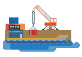 Important port
Wellington, offizielle Bezeichnung: Wellington City (Māori Te Whanganui-a-Tara, wobei damit der Wellington Harbour und seine Umgebung gemeint ist), ist die Hauptstadt von Neuseeland und stellt zusammen mit den angrenzenden Städten Lower Hutt, Upper Hutt und Porirua nach Auckland den zweitgrößten Ballungsraum des Landes dar. Die Stadt Wellington selbst hat rund 190.000 Einwohner.
Wellington City liegt am südlichen Ende der Nordinsel. Die Stadt verfügt über eine reine Landfläche von 290 km² und zählte zum Census im Jahr 2013 190.959 Einwohner.[2] Damit ist die Stadt zwar flächenmäßig die zweitkleinste Stadt der vier eigenständigen Städte in der Region Wellington, ist aber mit 658,7 Einwohner pro km² die Stadt mit der dritthöchsten Bevölkerungsdichte des Landes, hinter Hamilton und Tauranga.
Im Norden und Nordosten der Stadt bilden die Stadtgebiete von Porirua City und Hutt City die Grenze, im Westen tut dies die Küstenlinie der Tasmansee, im Süden die Küstenlinie der Cook Strait und im Osten der Wellington Harbour.[3] Der westliche Teil der Stadt ist durch eine Berglandschaft geprägt, die mit dem 537 m hohen Outlook Hill an der Südspitze ihre Höhepunkt findet.
Die Gegenden im Westen des bebauten Gebiets von Wellington steigen relativ steil zu einer hügeligen Mittelgebirgskette an, so dass die dort gelegenen Stadtteile mitunter um einiges höher als das Stadtzentrum liegen. Aufgrund seiner geographischen Beschaffenheit wird Wellington oft mit San Francisco verglichen. Der südlich des Stadtzentrums gelegene Mount Victoria ist ein beliebter Aussichtspunkt und eine der markantesten geographischen Besonderheiten der Stadt. Die Miramar Peninsula (spanisch; Seeblick) bildet den östlichsten Punkt der Stadt. Auf dem zu dieser Halbinsel führenden Isthmus befindet sich der Internationale Flughafen der Stadt und direkt östlich dieser Halbinsel die Hafeneinfahrt in den Wellington Harbour mit dem berüchtigten Barrett-Riff, dem schon zahlreiche Schiffe zum Opfer fielen. Die Wahine, die 1968 an dem Riff gesunken ist und 52 Menschen in den Tod gerissen hat, ist das wohl bekannteste Opfer. Im Naturhafen selbst gibt es die drei Inseln Matiu/Somes Island, Ward (Makaro) und Mokopuna, von denen nur die erste bewohnt ist. Im Norden mündet einer der großen Flüsse der Nordinsel, der Hutt River in die Bucht. In seinem Tal, dem Hutt Valley befinden sich die Städte Upper Hutt im Norden und Lower Hutt südlich davon. Die beiden Städte werden westlich von den Bergen des Akatarawa Forest als Ausläufer der Tararua Range und östlich von der Rimutaka Range eingegrenzt.
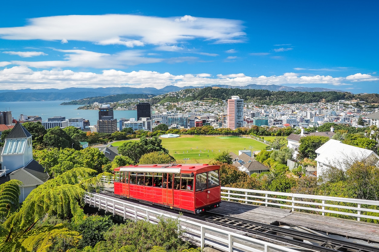
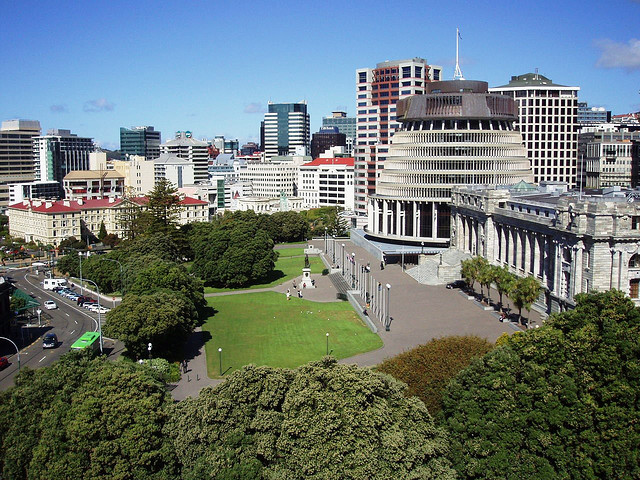
Bekannte Sehenswürdigkeiten sind das ältere neuseeländischen Parlamentsgebäude und das 1979 fertiggestellte Regierungsgebäude, Beehive (Bienenstock) genannt, in dem der Prime Minister und die Minister des Kabinetts ihre Büros haben und das Kabinett tagt; das historische Wellington Cable Car und der dadurch an die City angeschlossene Botanische Garten mitsamt Aussichtspunkt oberhalb der Victoria University of Wellington; das Old Government Building als größtes Holzgebäude der Südhalbkugel (heute die juristische Fakultät der Universität) sowie Mount Victoria als einer der besten Aussichtspunkte der Stadt. Old Saint Paul’s, die erste anglikanische Kathedrale, wurde ab 1855 als Holzkirche in neugotischen Formen errichtet. 1964 ging ihre Funktion an die neu erbaute Cathedral of Saint Paul über. Bischofskirche des römisch-katholischen Erzbistums Wellington ist die 1901 vollendete Sacred Heart Cathedral.
Während der Stadtentwicklung sind um den Beginn des 20. Jahrhunderts eine Reihe von Profanbauten entstanden, welche das Bild der Innenstadt mitbestimmen. Dazu zählen die Aida Konditorei und das Barber Building in der Cuba Street, das Thistle Inn als einer der ältesten Pubs Neuseelands, das Albemarle Hotel in der Ghuznee Street, das Antrim House inmitten höherer moderner Gebäude, Alcohol and Drug Dependence Centre Building, das Appraisal House in der Willis Street, das Ashleigh Court Private Hotel sowie der Aqua Vitae Bottle Store, als seltenes Zeugnis der frühen kolonialen Bebauung.
惠灵顿(英语:Wellington、毛利语:Te Whanganui-a-Tara 或 Poneke)是新西兰的首都,位于新西兰北岛南端,人口约四十万。它是新西兰的第二大城市,与悉尼和墨尔本一起成为大洋洲的文化中心。许多艺术家在此定居或活动,它还有许多艺术咖啡馆和生动的夜生活。
惠灵顿位于北岛的南端,与南岛隔库克海峡相望。在晴朗的日子里,人们可以隔海峡看到南岛上凯库拉岭的雪峰。城市北面是卡培提市的金色海岸。城市东面的里姆塔卡山将城市与盛产葡萄酒的怀拉拉帕平原隔开。
惠灵顿是世界最南方的首都,其纬度高达41度。由于港口和周围山脉之间的可用地带有限,它比新西兰其它城市的人口密度要高。由于它位于纬度40度的咆哮西风带,以及库克海峡对风的影响,他在当地有“多风的惠灵顿”之称号。
惠灵顿市中心的商业区是它的最重要部分,约6.2万人在那里工作(比较:奥克兰的居民数是惠灵顿的三倍,而它的中心商业区工作人员的数目仅比惠灵顿多4千)。惠灵顿的艺术和夜生活主要集中在中心商业区的南部,Te Aro区是新西兰最大的娱乐中心。
惠灵顿以其美丽的自然港口和绿色的山坡而著称。山坡上点缀着殖民时期遗留下来的盖瓦洋房。城市的中心商业区位于港口的附近。惠灵顿的尼可森海港的走向沿着一个活跃的地质断层。向西地势骤然高起,因此惠灵顿的许多市区高于市中心。
惠灵顿的南端是密拉马半岛,它与北岛的其它部分通过一条狭窄的地峡相连。惠灵顿国际机场也在这里。
ウェリントン(英語: Wellington、マオリ語: Te Whanga-nui-a-Tara)は、ニュージーランドの首都。同国2番目の都市圏で、オセアニアの首都の中では最も人口が多い。オセアニア有数の世界都市でもある。ウェリントン広域自治体(Wellington Region)に属し、ニュージーランド北島の南端にあり、ちょうど同国の国土の中央に位置する。マオリ語ではテ・ワンガヌイ=ア=タラあるいはポネケ(Poneke)という。
ニュージーランドの主要な金融機関はウェリントンとオークランドに分かれ、幾つかの企業は本社を両都市に置いている。ウェリントンはニュージーランドの政治の中心地であり、ニュージーランド議会とすべての行政機関の本庁舎が置かれている。
またウェリントンは、ニュージーランドの映画・演劇産業の中心地である。テ・パパ(Te Papa ニュージーランド国立博物館)、ニュージーランド交響楽団 (New Zealand Symphony Orchestra)、そしてロイヤル・ニュージーランド・バレエ団 (Royal New Zealand Ballet) が本拠地を置いている。隔年でニュージーランド国際アートフェスティバル (New Zealand International Arts Festival) も開催される。
小さくまとまった都心部では、都市の大きさのわりに大規模なアートシーンやカフェ文化、ナイトライフが展開されている。
ウェリントンの名前は、ワーテルローの戦いでナポレオン1世に勝利した初代ウェリントン公爵アーサー・ウェルズリーに敬意を表してつけられたものである。そしてその「ウェリントン」の爵号は、イングランド・サマセット州のウェリントンという町の名に由来する。
マオリ語ではウェリントンは2つの名前で呼ばれる。「テ・ワンガヌイ=ア=タラ (Te Whanganui-a-Tara)」はウェリントン港を指すもので、「タラ(ポリネシアの神話に登場する女神)の大いなる港」を意味する。もう一つの名称の「ポネケ」の方は、港のかつての名称「ポート・ニコルソン (Port Nicholson)」を縮めた愛称である「ポート・ニック (Port Nick)」の音訳でしかないと信じられているため、必ずしもマオリ語名とは言えないとされることも多い。
ウェリントンの都市圏は単独の地方自治体の境界を大きく越えて広がっている。「大ウェリントン (Greater Wellington)」あるいは「ウェリントン地方 (Wellington Region)」と呼ばれるのは、都市圏全体に加え、それを構成する市の市街地以外の部分、カピティ海岸 (Kapiti Coast)、それにリムタカ山脈 (Rimutaka Range) を挟んでワイララパ (Wairarapa) に至る範囲である。
Wellington (Māori: Te Whanganui-a-Tara [tɛ ˈfaŋanʉi a taɾa]) is the capital city and second most populous urban area of New Zealand, with 418,500 residents.[3] It is located at the south-western tip of the North Island, between Cook Strait and the Remutaka Range. Wellington is the major population centre of the southern North Island, and is the administrative centre of the Wellington Region, which also includes the Kapiti Coast and Wairarapa. Its latitude is 41°17′S, making it the world's southernmost capital of a sovereign state.[4] Wellington features a temperate maritime climate and is the world's windiest city, with an average wind speed of over 26 km/h (16 mph).[5]
The Wellington urban area comprises four local authorities: Wellington City, on the peninsula between Cook Strait and Wellington Harbour, contains the central business district and about half the population; Porirua on Porirua Harbour to the north is notable for its large Māori and Pacific Island communities; Lower Hutt and Upper Hutt are largely suburban areas to the northeast, together known as the Hutt Valley.
Situated near the geographic centre of the country, Wellington was well placed for trade. In 1839 it was chosen as the first major planned settlement for British immigrants coming to New Zealand. The settlement was named in honour of Arthur Wellesley, the first Duke of Wellington and victor of the Battle of Waterloo.
As the nation's capital since 1865, the New Zealand Government and Parliament, Supreme Court and most of the public service are based in the city. Architectural sights include the Government Building—one of the largest wooden buildings in the world—as well as the iconic Beehive. Wellington is also home to several of the largest and oldest cultural institutions in the nation such the National Archives, the National Library, the Museum of New Zealand Te Papa Tongarewa, and numerous theatres. It plays host to many artistic and cultural organisations, including the New Zealand Symphony Orchestra and Royal New Zealand Ballet. One of the world's most liveable cities, the 2014 Mercer Quality of Living Survey ranked Wellington 12th in the world.[6]
Wellington's economy is primarily service-based, with an emphasis on finance, business services, and government. It is the centre of New Zealand's film and special effects industries, and increasingly a hub for information technology and innovation,[7] with two public research universities. Wellington is one of New Zealand's chief seaports and serves both domestic and international shipping. The city is served by Wellington International Airport, the third busiest airport in the country. Wellington's transport network includes train and bus lines which reach as far as the Kapiti Coast and Wairarapa, and ferries connect the city to the South Island.
Wellington est la capitale de la Nouvelle-Zélande depuis 1865 et la deuxième ville la plus peuplée du pays. Elle est située à l'extrémité sud de l'île du Nord, dans la région de Wellington, au centre du pays. Cette situation en fait la capitale de pays la plus australe. Comme beaucoup de villes, l'aire urbaine de Wellington s'étend au-delà des frontières de son administration territoriale. Le Grand Wellington ou la région de Wellington comprend toute l'aire urbaine ainsi que les villes, les régions rurales, le Kapiti Coast, la chaine des monts Rimutaka et la Wairarapa.
Les principales institutions financières néo-zélandaises sont réparties entre Wellington et Auckland, et certaines organisations ont des bureaux dans les deux villes. Wellington est en revanche le centre politique de la Nouvelle-Zélande, le siège du parlement, des ministères et des départements d'État. Son centre-ville dense est le foyer d'une scène artistique, d'une culture des cafés et d'une vie nocturne que pourraient lui envier bon nombre de villes de taille similaire. Elle accueille également une industrie cinématographique d'échelle mondiale, ainsi qu'une scène théâtrale importante, Te Papa Tongarewa (le musée national), l'Orchestre symphonique de Nouvelle-Zélande et le Ballet national de Nouvelle-Zélande.
Wellington è la capitale della Nuova Zelanda, ed è la seconda città del paese, dopo Auckland.
Wellington è situata sulla punta sud-occidentale dell'isola del Nord e si trova tra lo Stretto di Cook e la zona di Rimutaka. È la città capitale più meridionale del mondo, ed è nel contempo anche la più remota capitale poiché lontana da qualsiasi altra.
L'area urbana di Wellington è il centro principale del sud dell'Isola del Nord, ed è il capoluogo della Regione di Wellington, che oltre alla zona urbana copre la costa Kapiti e Wairarapa.
La zona metropolitana della città comprende quattro quartieri: "Wellington City", sulla penisola tra lo stretto di Cook ed il porto, "Porirua City", a nord, "Lower Hutt City" e Upper Hutt City.
Wellington, inoltre, ha tre isole: Matiu, Makaro e Mokopuna. La prima di queste isole è stata usata come luogo di quarantena per le persone e gli animali, e anche come campo di internamento durante i due conflitti mondiali; oggi è un luogo di conservazione, in cui vengono protette specie in pericolo, proprio come Kapiti, che si trova più avanti rispetto alla costa. È possibile raggiungere queste isole tramite il traghetto Dominion Post.
Wellington ha subito gravi danni in una serie di terremoti nel 1848 (8,2 della scala Richter) e nel 1855. Questi terremoti trasformarono l'area intorno al porto in una palude; la zona è stata successivamente recuperata ed oggi vi si trova il Central Business District, il quartiere degli affari.
Una leggenda maori racconta che il grande navigatore polinesiano Kupe scoprì ed esplorò intorno al X secolo la zona dove sorge la città.
Il primo insediamento europeo si stabilì con l'arrivo dei coloni a bordo della nave Tory, il 20 settembre 1839; altre 150 persone arrivarono sulla nave Aurora il 22 gennaio 1840. I coloni costruirono le loro case alla foce della zona pianeggiante del fiume Hutt.
Nel 1865 Wellington divenne la capitale della Nuova Zelanda, in sostituzione di Auckland, dove William Hobson, l'aveva posta nel 1841. Il primo ministro della Nuova Zelanda, Alfred Domett, presentò al Parlamento una proposta di legge, in cui si esprimeva la necessità di trasferire la capitale in una località adatta.
Wellington (en maorí: Te Whanganui-a-Tara o Pōneke) es la capital de Nueva Zelanda, así como de la región de Wellington. Está localizada al sur de la isla Norte (North Island en inglés), en la que Wellington es la ciudad principal. Con 179 463 habitantes en 2006,1 es la tercera ciudad más poblada del país, después de Auckland y Christchurch.
Como muchas otras grandes ciudades y capitales, la ciudad se extiende más allá de los límites de su término municipal, y su área metropolitana o Gran Wellington incluye las poblaciones y áreas rurales cercanas, la costa de Kapiti y los montes Rimutaka hasta la región de Wairarapa. El área urbana incluye cuatro ciudades: Wellington, entre el estrecho de Cook y el puerto de Wellington, abarca la mitad de la población de todas las áreas y por lo tanto es su centro económico; al norte se encuentra Porirua, se caracteriza por su gran afluencia de maoríes y procedentes de las islas del pacífico; Lower Hutt y Upper Hutt al noreste, situadas junto al valle de Hutt.
La ciudad es un importante centro financiero y de negocios en el país. Es también un importante centro cultural, que alberga el museo Te Papa ("nuestro lugar" en lengua maorí), el ballet, la orquesta sinfónica y la producción cinematográfica en Nueva Zelanda. Fue fundada a finales de 1830 y se convirtió en la capital de Nueva Zelanda en 1865, en sustitución de Auckland. La ciudad está situada a 41 grados latitud sur y es la capital nacional más austral en el mundo.
Веллингто́н, Уэ́ллингтон (англ. Wellington) — столица Новой Зеландии, второй по численности населения город страны с учётом агломерации, крупнейшая столица среди стран Океании и самая южная столица в мире[2]. Город расположен в регионе Веллингтон в южной части острова Северный. Маорийское название Веллингтона — Те Фанауи-а-Тара (маори Te Whanganui-a-Tara). В начале XIX века начался процесс захвата европейцами земель коренного населения маори. В 1839 году полковник Уильям Уэйкфилд, служивший в Новозеландской компании, основал город немного северней его современного расположения. Однако в 1840 году сильные разливы реки Хатт заставили переселиться южнее. Первые переселенцы назвали город Веллингтоном в честь фельдмаршала герцога Артура Уэлсли Веллингтона, командующего объединёнными англо-голландскими войсками, в благодарность за ту помощь, которую он оказал первым переселенцам. Сильное землетрясение 1848 года вызвало серьёзные разрушения в городе, а в 1854 году по той же причине погибло много людей. В 1865 году Веллингтон стал столицей Новой Зеландии, которой остается и поныне. Веллингтон — красивый и уютный город, с большим количеством мостов, виадуков, тоннелей, парков и скверов. Многообразен его архитектурный облик: эклектические сооружения, относящееся к XIX — первой половине XX веков, на улицах города сочетаются со зданиями современного стиля и массовой деревянной застройкой. Одной из интереснейших построек столицы является круглое здание парламента, которое горожане называют ульем. Напротив парламента расположен бывший дворец правительства, являющейся второй в мире по величине постройкой из дерева. Также привлекает внимание собор Святого Павла. Впечатляет столичный ботанический сад, который расположился на склоне высокой горы. Особой гордостью города можно также считать зоопарк, в котором животные размещаются чаще всего не в клетках, а в просторных открытых вольерах.

 Eat and Drink

Christchurch [ˈkɹaɪsttʃɜːtʃ] ist eine an der Ostküste der Südinsel Neuseelands in der Region Canterbury gelegene Stadt mit 341,469 Einwohnern.
Christchurch gilt als die „englischste“ Stadt Neuseelands, was sich heute noch in der Architektur nachvollziehen lässt. Der Māori-Name der Stadt ist Ōtautahi, benannt nach einem Häuptling der Māori, der am Avon River siedelte.
 Financial

Source: Building Societies Association updated for subsequent mergers
| Name | Group assets [11] | Other building society trading names | Number of branches & agencies | No. of full time staff | No. of part time staff | Provides current account | |
|---|---|---|---|---|---|---|---|
| 1 | Nationwide Building Society | £208,939m | 650 branches | c.14,400 | c.4000 | Yes | |
| 2 | Yorkshire Building Society | £39,600m | Uses the former Norwich & Peterborough and Chelsea building societies as trading names. | 230 branches & 96 agencies | 3599 | 96 | No |
| 3 | Coventry Building Society[* 1] | £38,300m | 70 branches & 19 agencies | 1592 | 642 | No (Basic bank account with cash card available instead) | |
| 4 | Skipton Building Society[12][13] | £19,000m | 95 branches & 3 agencies (87 by 30/09/17) | 1398 | 374 | No | |
| 5 | Leeds Building Society | £15,900m | Formerly Leeds and Holbeck Building Society. Adopted current name after the un-connected Leeds Permanent Building Society merged with the Halifax Building Society in 1995 | 57 branches | 1027 | 214 | No |
| 6 | Principality Building Society | £8,202m | 53 branches & 18 agencies | 887 | 232 | No | |
| 7 | West Bromwich Building Society | £5,737m | 37 branches | 615 | 138 | No | |
| 8 | Newcastle Building Society | £3,622m | 27 branches (25 by Dec 17) & 1 agency | 672 | 279 | No | |
| 9 | Nottingham Building Society | £3,600m | 56 branches | 477 | 201 | No | |
| 10 | Cumberland Building Society | £2,130m | 34 branches | 311 | 191 | Yes (If customer resides within their branch operating area) | |
| 11 | Progressive Building Society[* 1] | £1,794m | 12 branches & 39 agencies | 120 | 58 | No | |
| 12 | National Counties Building Society | £1,569m | Uses the Family Building Society as a trading name. | 1 branch | 130 | 13 | No |
| 13 | Cambridge Building Society | £1,194m | 13 branches | 143 | 49 | No | |
| 14 | Saffron Building Society | £1,115m | 11 branches & 7 agencies | 146 | 35 | No | |
| 15 | Monmouthshire Building Society | £1,073m | 11 branches & 18 agencies | 85 | 60 | No | |
| 16 | Leek United Building Society | £891m | 12 branches & 2 agencies | 120 | 44 | No | |
| 17 | Furness Building Society | £883m | 9 branches & 14 agencies | 96 | 81 | No | |
| 18 | Newbury Building Society | £869m | 11 branches | 107 | 40 | No | |
| 19 | Hinckley & Rugby Building Society | £636m | 8 branches & 4 agencies | 87 | 29 | No | |
| 20 | Ipswich Building Society[* 1] | £584m | 9 branches & 4 agencies | 71 | 52 | No | |
| 21 | Darlington Building Society | £532m | 10 branches | 86 | 27 | No | |
| 22 | Market Harborough Building Society | £427m | 6 branches & 1 agency | 68 | 50 | No | |
| 23 | Melton Mowbray Building Society[* 1] | £419m | 3 branches | 58 | 30 | No | |
| 24 | Marsden Building Society | £416m | 8 branches | 63 | 16 | No | |
| 25 | Scottish Building Society | £389m | 6 branches & 62 agencies | 52 | 19 | No | |
| 26 | Manchester Building Society | £382m | 1 branch & 4 agencies | 43 | 7 | No | |
| 27 | Hanley Economic Building Society | £378m | 6 branches & 1 agency | 51 | 22 | No | |
| 28 | Tipton & Coseley Building Society[* 1] | £372m | 4 branches | 53 | 30 | No | |
| 29 | Dudley Building Society | £354m | 6 branches | 52 | 39 | No | |
| 30 | Mansfield Building Society[* 1] | £329m | 4 branches | 53 | 20 | No | |
| 31 | Harpenden Building Society[* 1] | £317m | 6 branches | 41 | 23 | No | |
| 32 | Loughborough Building Society[* 1] | £303m | 3 branches & 2 agencies | 42 | 13 | No | |
| 33 | Vernon Building Society | £300m | 6 branches | 43 | 25 | No | |
| 34 | Bath Building Society | £299m | 2 branches & 6 agencies | 53 | 14 | No | |
| 35 | Stafford Railway Building Society[* 1] | £271m | 1 branch | 12 | 19 | No | |
| 36 | Swansea Building Society | £268m | 3 branches | 22 | 14 | No | |
| 37 | Teachers Building Society | £253m | 1 branch | 29 | 10 | No | |
| 38 | Buckinghamshire Building Society[* 1] | £225m | 1 branch | 25 | 14 | No | |
| 39 | Chorley & District Building Society[* 1] | £220m | 3 branches | 36 | 14 | No | |
| 40 | Beverley Building Society[* 1] | £191m | 1 branch | 15 | 7 | No | |
| 41 | Holmesdale Building Society[* 1] | £190m | 1 branch | 21 | 3 | No | |
| 42 | Ecology Building Society[* 1] | £146m | 1 branch | 23 | 2 | No | |
| 43 | Earl Shilton Building Society[* 1] | £124m | 2 branches | 17 | 10 | No | |
| 44 | Penrith Building Society[* 1] | £106m | 1 branch | 14 | 7 | No |
 Economy and trade
Australia
Belgium
Chile
Denmark
Germany
Estonia
Finland
France
Greece
Ireland
Iceland
Israel
Italy
Japan
Canada
Luxembourg
Mexico
New Zealand
Netherlands
Norwegen
OECD
Emiel van Lennep
OECD
Don Johnston
OECD
Jean-Claude Paye
OECD
José Ángel Gurría
OECD
Staffan Sohlman
OECD
Thorkil Kristensen
Austria
Poland
Portugal
Republic of Korea
Sweden
Switzerland
Slovakia
Slovenia
Spain
Czech Republic
Turkey
Hungary
United States
United Kingdom
Economy and trade
Australia
Belgium
Chile
Denmark
Germany
Estonia
Finland
France
Greece
Ireland
Iceland
Israel
Italy
Japan
Canada
Luxembourg
Mexico
New Zealand
Netherlands
Norwegen
OECD
Emiel van Lennep
OECD
Don Johnston
OECD
Jean-Claude Paye
OECD
José Ángel Gurría
OECD
Staffan Sohlman
OECD
Thorkil Kristensen
Austria
Poland
Portugal
Republic of Korea
Sweden
Switzerland
Slovakia
Slovenia
Spain
Czech Republic
Turkey
Hungary
United States
United Kingdom
 Important International Organizations

経済協力開発機構(けいざいきょうりょくかいはつきこう)は、国際経済全般について協議することを目的とした国際機関。公用語の正式名称は、英語では"Organisation[1] for Economic Co-operation and Development"(イギリス英語表記)、フランス語では"Organisation de Coopération et de Développement Economiques"。略称は英語ではOECD、フランス語ではOCDE。
本部事務局はパリ16区の旧ラ・ミュエット宮殿に置かれている。事務総長はアンヘル・グリア。
The Organisation for Economic Co-operation and Development (OECD; French: Organisation de Coopération et de Développement Économiques, OCDE) is an intergovernmental economic organisation with 37 member countries,[1] founded in 1961 to stimulate economic progress and world trade. It is a forum of countries describing themselves as committed to democracy and the market economy, providing a platform to compare policy experiences, seek answers to common problems, identify good practices and coordinate domestic and international policies of its members. Generally, OECD members are high-income economies with a very high Human Development Index (HDI) and are regarded as developed countries. As of 2017, the OECD member countries collectively comprised 62.2% of global nominal GDP (US$49.6 trillion)[3] and 42.8% of global GDP (Int$54.2 trillion) at purchasing power parity.[4] The OECD is an official United Nations observer.[5]
In 1948, the OECD originated as the Organisation for European Economic Co-operation (OEEC),[6] led by Robert Marjolin of France, to help administer the Marshall Plan (which was rejected by the Soviet Union and its satellite states).[7] This would be achieved by allocating United States financial aid and implementing economic programs for the reconstruction of Europe after World War II. (Similar reconstruction aid was sent to the war-torn Republic of China and post-war Korea, but not under the name "Marshall Plan".)[8]
In 1961, the OEEC was reformed into the Organisation for Economic Co-operation and Development by the Convention on the Organisation for Economic Co-operation and Development and membership was extended to non-European states.[9][10] The OECD's headquarters are at the Château de la Muette in Paris, France.[11] The OECD is funded by contributions from member countries at varying rates and had a total budget of €386 million in 2019.[2]
Although OECD does not have a power to enforce its decisions, which further require unanimous vote from its members, it is recognized as highly influential publisher of mostly economic data through publications as well as annual evaluations and rankings of members countries.[12]
L'Organisation de coopération et de développement économiques (OCDE) est une organisation internationale d'études économiques, dont les pays membres — des pays développés pour la plupart — ont en commun un système de gouvernement démocratique et une économie de marché. Elle joue essentiellement un rôle d'assemblée consultative1.
L'OCDE a succédé à l'Organisation européenne de coopération économique (OECE) issue du plan Marshall et de la Conférence des Seize (Conférence de coopération économique européenne) qui a existé de 1948 à 1960. Son but était l'établissement d'une organisation permanente chargée en premier lieu d'assurer la mise en œuvre du programme de relèvement commun (le plan Marshall), et, en particulier, d'en superviser la répartition2.
En 2020, l'OCDE compte 37 pays membres et regroupe plusieurs centaines d'experts. Elle publie fréquemment des études économiques et sociales — analyses, prévisions et recommandations de politique économique — et des statistiques, principalement concernant ses pays membres.
Le siège de l'OCDE se situe à Paris (16e), au château de la Muette. L'organisation possède également des bureaux dans plusieurs autres métropoles, notamment à Berlin, Mexico, Tokyo et Washington.
L'Organizzazione per la cooperazione e lo sviluppo economico (OCSE) – in inglese Organization for Economic Co-operation and Development (OECD), e in francese Organisation de coopération et de développement économiques (OCDE) – è un'organizzazione internazionale di studi economici per i paesi membri, paesi sviluppati aventi in comune un'economia di mercato.
L'organizzazione svolge prevalentemente un ruolo di assemblea consultiva che consente un'occasione di confronto delle esperienze politiche, per la risoluzione dei problemi comuni, l'identificazione di pratiche commerciali e il coordinamento delle politiche locali e internazionali dei paesi membri[1]. Ha sede a Parigi nello Château de la Muette[2].
Gli ultimi paesi ad aver aderito all'OCSE sono la Colombia (28 aprile 2020),la Lettonia (1º luglio 2016) e la Lituania (5 luglio 2018), per un totale di 36 paesi membri.
La Organización para la Cooperación y el Desarrollo Económico1 (OCDE) es un organismo de cooperación internacional, compuesto por 37 estados,34 cuyo objetivo es coordinar sus políticas económicas y sociales. La OCDE fue fundada en 1961 y su sede central se encuentra en el Château de la Muette en París (Francia). Los idiomas oficiales de la entidad son el francés y el inglés.2
En la OCDE, los representantes de los países miembros se reúnen para intercambiar información y armonizar políticas con el objetivo de maximizar su crecimiento económico y colaborar a su desarrollo y al de los países no miembros.
Conocida como «club de los países ricos»,56 a partir de 2017, sus países miembros comprendieron colectivamente el 62,2 % del PIB nominal global (US$49,6 billones) y el 42,8 % del PIB global (Int US$54,2 billones).7
Организа́ция экономи́ческого сотру́дничества и разви́тия (сокр. ОЭСР, англ. Organisation for Economic Co-operation and Development, OECD) — международная экономическая организация развитых стран, признающих принципы представительной демократии и свободной рыночной экономики.
Создана в 1948 году под названием Организа́ция европе́йского экономи́ческого сотру́дничества (англ. Organisation for European Economic Co-operation, OEEC) для координации проектов экономической реконструкции Европы в рамках плана Маршалла.
Штаб-квартира организации располагается в Шато де ла Мюетт, в Париже. Генеральный секретарь (с 2006 года) — Хосе Анхель Гурриа Тревиньо (Мексика). Руководящим органом ОЭСР является совет представителей стран — членов организации. Все решения в нём принимаются на основе консенсуса.
По данным на 2011 год, в странах ОЭСР проживало 18 % населения мира[2].
 Geography


Nobel prize
Nobel Memorial Prize in Economic Sciences
Nobel prize
Nobel Prize in Chemistry
Nobel prize
University/Institute

