
Deutsch-Chinesische Enzyklopädie, 德汉百科
 Kenya
Kenya
 Geography
Amapá
Amazonas
Brazil
Columbia
Demokratische Republik Kongo
Ecuador
Gabun
Indonesia
Kenya
Pará
Republik Kongo
Roraima
Sao Tome und Principe
Somalia
Uganda
Geography
Amapá
Amazonas
Brazil
Columbia
Demokratische Republik Kongo
Ecuador
Gabun
Indonesia
Kenya
Pará
Republik Kongo
Roraima
Sao Tome und Principe
Somalia
Uganda
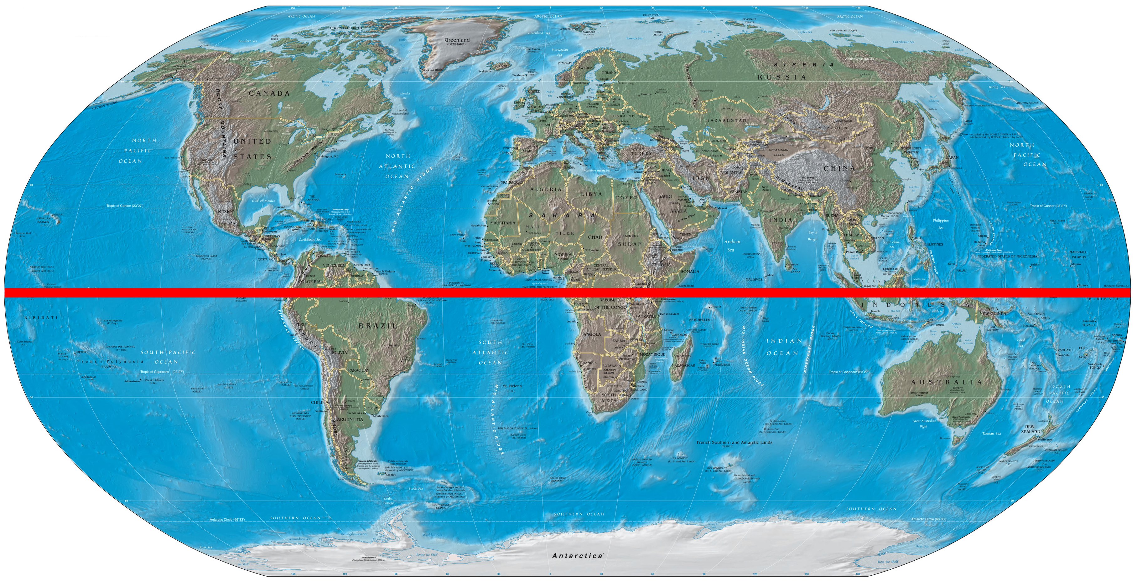
赤道通常指地球表面的点随地球自转产生的轨迹中周长最长的圆周线,长约40,000公里。如果把地球看做一个绝对的球体的话,赤道距离南北两极相等。它把地球分为南北两半球,其以北是北半球,以南是南半球,是划分纬度的基线,赤道的纬度为0°。赤道的78.7%被海洋覆盖,余下的21.3%为陆地。
赤道的纬度被定义为0°,与两条极圈及两条回归线——北回归线和南回归线组成地球表面五条重要的纬线,而赤道又是其中唯一一个大圆。地球赤道在天球上的投影则是天球赤道。
在太阳的季节性视运动中,每年经过赤道两次,分别在春分、秋分。此时太阳光在赤道处与地球表面垂直,即直射赤道。
由于太阳几乎全年都垂直地升落,赤道上看到的日出和日落是地球表面最快的。赤道上的昼长(日出到日落)也几乎全年保持不变[1];由于大气折射[2],以及日出日落是太阳的边缘而非中心触及地平线的缘故,每天的白昼都比夜晚长约14分钟。
Der Äquator eines Planeten oder sonstigen rotationsellipsoiden Himmelskörpers ist der auf seiner Oberfläche angenommene Großkreis, auf dessen Ebene (der Äquatorebene) die Rotationsachse senkrecht steht.[1] Die Erdoberfläche wird vom Äquator in eine Nord- und eine Südhälfte unterteilt, woher der lat. Name „Gleichmacher“ (veraltet „Gleicher“) stammt. Er ist Bezugskreis für die parallelen Kleinkreise, die zur Bemaßung der Erde in Nord-Süd-Richtung mit Hilfe von Breitenkreisen verwendet werden. Er selbst hat die geographische Breite 0°.
Der Schnitt der Äquatorebene der Erde mit der um die Erde gedachten Himmelskugel ist der Himmelsäquator.
In der Geometrie wird der Begriff Äquator allgemein auf die Kugel in Verbindung mit einer durch ihren Mittelpunkt festgelegten Achse angewendet.
 Economy and trade
 Afghanistan
Egypt
Albania
Angola
Antigua and Barbuda
Argentina
Armenia
Australia
Bahrain
Bangladesh
Barbados
Belgium
Belize
Benin
Bolivia
Botsuana
Brazil
Brunei Darussalam
Bulgaria
Burkina Faso
Burundi
Chile
China
Columbia
Costa Rica
Côte d´Ivoire
Cuba
Denmark
Demokratische Republik Kongo
Germany
Dominica
Dominikanische Republik
Djibouti
Ecuador
Estonia
Afghanistan
Egypt
Albania
Angola
Antigua and Barbuda
Argentina
Armenia
Australia
Bahrain
Bangladesh
Barbados
Belgium
Belize
Benin
Bolivia
Botsuana
Brazil
Brunei Darussalam
Bulgaria
Burkina Faso
Burundi
Chile
China
Columbia
Costa Rica
Côte d´Ivoire
Cuba
Denmark
Demokratische Republik Kongo
Germany
Dominica
Dominikanische Republik
Djibouti
Ecuador
Estonia
 European Union
Fidschi
European Union
Fidschi
 Financial
Finland
France
Gabun
Gambia
Georgia
Ghana
Grenada
Greece
Guatemala
Guinea
Guinea-Bissau
Guyana
Honduras
Hongkong Tebiexingzhengqu-HK
India
Indonesia
Ireland
Iceland
Israel
Italy
Jamaika
Japan
Yemen
Jordan
Cambodia
Cameroon
Canada
Kap Verde
Kasachstan
Katar
Kenya
Kyrgyzstan
Croatia
Kuwait
Laos
Lesotho
Latvia
Liberia
Liechtenstein
Lithuania
Luxembourg
Macau Tebiexingzhengqu-MO
Madagaskar
Malawi
Malta
Morocco
Mauritania
Mauritius
Mexico
Moldawien
Financial
Finland
France
Gabun
Gambia
Georgia
Ghana
Grenada
Greece
Guatemala
Guinea
Guinea-Bissau
Guyana
Honduras
Hongkong Tebiexingzhengqu-HK
India
Indonesia
Ireland
Iceland
Israel
Italy
Jamaika
Japan
Yemen
Jordan
Cambodia
Cameroon
Canada
Kap Verde
Kasachstan
Katar
Kenya
Kyrgyzstan
Croatia
Kuwait
Laos
Lesotho
Latvia
Liberia
Liechtenstein
Lithuania
Luxembourg
Macau Tebiexingzhengqu-MO
Madagaskar
Malawi
Malta
Morocco
Mauritania
Mauritius
Mexico
Moldawien
 Mongolei
Montenegro
Mosambik
Myanmar
Namibia
Nepal
New Zealand
Nicaragua
Netherlands
Niger
Nigeria
Nordmazedonien
Norwegen
Oman
Austria
Pakistan
Panama
Papua-Neuguinea
Paraguay
Peru
Philippines
Poland
Portugal
Republik El Salvador
Republik Haiti
Republik Kongo
Republic of Korea
Ruanda
Romania
Russia
Salomonen
Sambia
Samoa
Saudi Arabia
Sweden
Sweden
Switzerland
Mongolei
Montenegro
Mosambik
Myanmar
Namibia
Nepal
New Zealand
Nicaragua
Netherlands
Niger
Nigeria
Nordmazedonien
Norwegen
Oman
Austria
Pakistan
Panama
Papua-Neuguinea
Paraguay
Peru
Philippines
Poland
Portugal
Republik El Salvador
Republik Haiti
Republik Kongo
Republic of Korea
Ruanda
Romania
Russia
Salomonen
Sambia
Samoa
Saudi Arabia
Sweden
Sweden
Switzerland
 Genf
Senegal
Seychellen
Sierra Leone
Simbabwe
Singapore
Slovakia
Slovenia
Spain
Sri Lanka
Saint Kitts and Nevis
St. Lucia
St. Vincent and the Grenadines
South Africa
Suriname
Swasiland
Tajikistan
Taiwan Sheng-TW
Tansania
Thailand
Togo
Tonga
Trinidad und Tobago
Tschad
Czech Republic
Tunisia
Turkey
Uganda
Ukraine
Hungary
Uruguay
Vanuatu
Venezuela
United Arab Emirates
United States
United Kingdom
Vietnam
Genf
Senegal
Seychellen
Sierra Leone
Simbabwe
Singapore
Slovakia
Slovenia
Spain
Sri Lanka
Saint Kitts and Nevis
St. Lucia
St. Vincent and the Grenadines
South Africa
Suriname
Swasiland
Tajikistan
Taiwan Sheng-TW
Tansania
Thailand
Togo
Tonga
Trinidad und Tobago
Tschad
Czech Republic
Tunisia
Turkey
Uganda
Ukraine
Hungary
Uruguay
Vanuatu
Venezuela
United Arab Emirates
United States
United Kingdom
Vietnam
 Important International Organizations
World Trade Organization
Roberto Azevêdo
World Trade Organization
Mike Moore
World Trade Organization
Ngozi Okonjo-Iweala
World Trade Organization
Pascal Lamy
World Trade Organization
Peter Sutherland
World Trade Organization
Renato Ruggiero
World Trade Organization
Supachai Panitchpakdi
Central African Republic
Cyprus
Important International Organizations
World Trade Organization
Roberto Azevêdo
World Trade Organization
Mike Moore
World Trade Organization
Ngozi Okonjo-Iweala
World Trade Organization
Pascal Lamy
World Trade Organization
Peter Sutherland
World Trade Organization
Renato Ruggiero
World Trade Organization
Supachai Panitchpakdi
Central African Republic
Cyprus

世界贸易组织(简称世贸组织或世贸;英语:World Trade Organization,缩写为 WTO;法语:Organisation Mondiale du Commerce,缩写为 OMC;西班牙语:Organización Mundial del Comercio,缩写为 OMC)是负责监督成员经济体之间各种贸易协议得到执行的一个国际组织,前身是1948年起实施的关税及贸易总协定的秘书处。
世贸总部位于瑞士日内瓦,现任总干事是罗伯托·阿泽维多。截至2016年7月29日,世界贸易组织共有164个成员。[5]世界贸易组织的职能是调解纷争,加入WTO不算签订一种多边贸易协议,但其设置的入会门槛可以做为愿意降低关税、法政上配合、参与国际贸易的门票,它是贸易体制的组织基础和法律基础,是众多贸易协定的管理者,是各成员贸易立法的监督者,是就贸易提供解决争端和进行谈判的场所。该机构是当代最重要的国际经济组织之一,其成员间的贸易额占世界贸易额的绝大多数,被称为“经济联合国”。
Die Welthandelsorganisation (englisch World Trade Organization, WTO; französisch Organisation mondiale du commerce, OMC; spanisch Organización Mundial de Comercio, OMC) ist eine internationale Organisation mit Sitz in Genf, die sich mit der Regelung von Handels- und Wirtschaftsbeziehungen beschäftigt. Sie wurde am 15. April 1994 aus dem General Agreement on Tariffs and Trade (GATT) in der Uruguay-Runde nach siebenjähriger Verhandlungszeit gegründet. Am 1. Januar 1995 nahm sie ihre Arbeit in Genf auf. Die WTO ist neben dem IWF und der Weltbank eine der zentralen internationalen Organisationen, die Handels- und Wirtschaftspolitik mit globaler Reichweite verhandelt.
世界貿易機関(せかいぼうえききかん、英: World Trade Organization、略称:WTO)は、自由貿易促進を主たる目的として創設された国際機関である。常設事務局がスイスのジュネーブに置かれている。
GATT(ガット)ウルグアイ・ラウンドにおける合意によって、世界貿易機関を設立するマラケシュ協定(WTO設立協定)に基づいて1995年1月1日にGATTを発展解消させて成立した。
本来GATTは、第二次世界大戦後の安定を見据え、国際通貨基金および国際復興開発銀行とともに設立が予定されていた国際貿易機関(ITO)の設立準備の際に、暫定協定として結ばれたものであった。国際貿易機関の設立が廃案となり、GATTがその代替として発展強化されていくうちに、再びこの分野の常設機関が求められ、WTOが設立されることとなった。発展解消であるため、GATTの事務局及び事務局長もWTOへと引き継がれることとなった[4]。
WTOはGATTを継承したものであるが、GATTが協定(Agreement)に留まったのに対し、WTOは機関(Organization)であるのが根本的な違いである。
を基本原則としている。また、物品貿易だけでなく金融、情報通信、知的財産権やサービス貿易も含めた包括的な国際通商ルールを協議する場である。
対抗処置の発動では、紛争処理機関(パネル)の提訴に対し全加盟国による反対がなければ採択されるというネガティブ・コンセンサス方式(逆コンセンサス方式)を採用した強力な紛争処理能力を持つ。これは国際組織としては稀な例であり、コンセンサス方式を採っていたGATTとの大きな違いで、WTOの特徴の一つといえる。
新多角的貿易交渉(新ラウンド)は、2001年11月にカタールのドーハで行われた第4回WTO閣僚会議で開始を決定し、ドーハ・ラウンドと呼ばれていた。2002年2月1日の貿易交渉委員会で新ラウンドがスタートした。しかし9年に及ぶ交渉は先進国と、急速に台頭してきたBRICsなど新興国との対立によって中断と再開を繰り返した末、ジュネーブで行われた第4回WTO閣僚会議(2011年12月17日)で「交渉を継続していくことを確認するものの、近い将来の妥結を断念する」(議長総括)となり事実上停止状態になった。
その後、2013年のバリ島における閣僚会議で、貿易円滑化協定を含む合意が成立し、2014年7月まで貿易円滑化協定をWTO協定に加える(附属書1Aに追加)するための文書を一般理事会で採択すべきとされた[5]。しかしインドが合意を蒸し返す状態で反対したため期限までに採択できなかった[6]。その後食糧備蓄への補助金の問題で先進国側が譲歩することでようやくインドが合意し、2014年11月27日の一般理事会で貿易円滑化協定が採択された[6]。WTO加盟国の3分の2が改正を受諾した日に発効することになっており、2017年2月22日にこの要件を満たし、協定が発効した。
The World Trade Organization (WTO) is an intergovernmental organization that regulates international trade. The WTO officially commenced on 1 January 1995 under the Marrakesh Agreement, signed by 124 nations on 15 April 1994, replacing the General Agreement on Tariffs and Trade (GATT), which commenced in 1948. It is the largest international economic organization in the world.[5][6]
The WTO deals with regulation of trade in goods, services and intellectual property between participating countries by providing a framework for negotiating trade agreements and a dispute resolution process aimed at enforcing participants' adherence to WTO agreements, which are signed by representatives of member governments[7]:fol.9–10 and ratified by their parliaments.[8] The WTO prohibits discrimination between trading partners, but provides exceptions for environmental protection, national security, and other important goals.[9] Trade-related disputes are resolved by independent judges at the WTO through a dispute resolution process.[9]
The WTO's current Director-General is Roberto Azevêdo,[10][11] who leads a staff of over 600 people in Geneva, Switzerland.[12] A trade facilitation agreement, part of the Bali Package of decisions, was agreed by all members on 7 December 2013, the first comprehensive agreement in the organization's history.[13][14] On 23 January 2017, the amendment to the WTO Trade Related Aspects of Intellectual Property Rights (TRIPS) Agreement marks the first time since the organization opened in 1995 that WTO accords have been amended, and this change should secure for developing countries a legal pathway to access affordable remedies under WTO rules.[15]
Studies show that the WTO boosted trade,[16][17][9] and that barriers to trade would be higher in the absence of the WTO.[18] The WTO has highly influenced the text of trade agreements, as "nearly all recent [preferential trade agreements (PTAs)] reference the WTO explicitly, often dozens of times across multiple chapters... in many of these same PTAs we find that substantial portions of treaty language—sometime the majority of a chapter—is copied verbatim from a WTO agreement."[19]
L'Organisation mondiale du commerce (OMC ; en anglais : World Trade Organization, WTO, en espagnol : Organización Mundial del Comercio, OMC) est une organisation internationale qui s'occupe des règles régissant le commerce international entre les pays. Au cœur de l'organisation se trouvent les accords de l'OMC, négociés et signés en avril 1994 à Marrakech1 par la majeure partie des puissances commerciales du monde2 et ratifiés par leurs assemblées parlementaires. L'OMC a pour but principal de favoriser l'ouverture commerciale. Pour cela, elle tâche de réduire les obstacles au libre-échange, d'aider les gouvernements à régler leurs différends commerciaux et d'assister les exportateurs, les importateurs et les producteurs de marchandises et de services dans leurs activités.
Depuis 2001, le cycle de négociation mené par l'OMC est le Cycle de Doha3. Bien que l'OMC ne soit pas une agence spécialisée de l'ONU, elle entretient des liens avec cette dernière4. Le siège de l'OMC est au Centre William-Rappard, à Genève. Depuis le 1er septembre 2013, l'organisation est présidée par le Brésilien Roberto Azevêdo qui a été élu directeur général.
L'Organizzazione mondiale del commercio, abbreviato in OMC (in inglese: World Trade Organization, WTO), è un'organizzazione internazionale creata allo scopo di supervisionare numerosi accordi commerciali tra gli stati membri. Vi aderiscono[3] 164 Paesi, a cui se ne aggiungono altri 22 con ruolo di osservatori,[4] comprendendo così oltre il 95% del commercio mondiale di beni e servizi.[5]
La sede dell'OMC si trova, dal 1995, presso il Centro William Rappard a Ginevra, Svizzera.[6]
La Organización Mundial del Comercio (OMC) fue establecida en 1995. Tiene su sede en Ginebra, Suiza, y sus idiomas oficiales son el inglés, el francés y el español. La OMC no forma parte del sistema de las Naciones Unidas, y tampoco de los organismos de Bretton Woods como el Banco Mundial o el FMI.Nota 1
Всеми́рная торго́вая организа́ция (ВТО; англ. World Trade Organization (WTO), фр. Organisation mondiale du commerce (OMC), исп. Organización Mundial del Comercio) — международная организация, созданная 1 января 1995 года с целью либерализации международной торговли и регулирования торгово-политических отношений государств-членов. ВТО образована на основе Генерального соглашения по тарифам и торговле (ГАТТ), заключенного в 1947 году и на протяжении почти 50 лет фактически выполнявшего функции международной организации, но не являвшегося тем не менее международной организацией в юридическом смысле.
ВТО отвечает за разработку и внедрение новых торговых соглашений, а также следит за соблюдением членами организации всех соглашений, подписанных большинством стран мира и ратифицированных их парламентами. ВТО строит свою деятельность, исходя из решений, принятых в 1986—1994 годах в рамках Уругвайского раунда и более ранних договоренностей ГАТТ. Обсуждения проблем и принятие решений по глобальным проблемам либерализации и перспективам дальнейшего развития мировой торговли проходят в рамках многосторонних торговых переговоров (раунды). К настоящему времени проведено 8 раундов таких переговоров, включая Уругвайский, а в 2001 году стартовал девятый в Дохе, Катар. Организация пытается завершить переговоры по Дохийскому раунду переговоров, который был начат с явным акцентом на удовлетворение потребностей развивающихся стран. По состоянию на декабрь 2012 года будущее раунда переговоров в Дохе остаётся неопределённым: программа работы состоит из 21 части, а первоначально установленный окончательный срок 1 января 2005 года был давно пропущен[3]. В ходе переговоров возник конфликт между стремлением к свободной торговле и стремлением множества стран к протекционизму, особенно в плане сельскохозяйственных субсидий. До сих пор эти препятствия остаются главными и мешают любому прогрессу для запуска новых переговоров в рамках Дохийского раунда. По состоянию на июль 2012 года, существуют различные группы переговоров в системе ВТО для решения текущих вопросов в плане сельского хозяйства, что приводит к застою в самих переговорах[4].
Штаб-квартира ВТО расположена в Женеве, Швейцария. Глава ВТО (генеральный директор) — Роберту Карвалью ди Азеведу, в штате самой организации около 600 человек[5].
На 26 апреля 2015 года в ВТО состояли 162 страны[6].
Правила ВТО предусматривают ряд льгот для развивающихся стран. В настоящее время развивающиеся страны — члены ВТО имеют (в среднем) более высокий относительный уровень таможенно-тарифной защиты своих рынков по сравнению с развитыми. Тем не менее, в абсолютном выражении общий размер таможенно-тарифных санкций в развитых странах гораздо выше, вследствие чего доступ на рынки высокопередельной продукции из развивающихся стран серьёзно ограничен[7].
Правила ВТО регулируют только торгово-экономические вопросы. Попытки США и ряда европейских стран начать дискуссию об условиях труда (что позволило бы считать недостаточную законодательную защиту работников конкурентным преимуществом) были отвергнуты из-за протестов развивающихся стран, которые утверждали, что такие меры только ухудшат благосостояние работников в связи с сокращением числа рабочих мест, снижением доходов и уровня конкурентоспособности[7].
Mitglieder der WTO
| Staat | Beitrittsdatum |
|---|---|
 Ägypten Ägypten |
30. Juni 1995 |
 Afghanistan Afghanistan |
29. Juli 2016 |
 Albanien Albanien |
8. September 2000 |
 Angola Angola |
23. November 1996 |
 Antigua und Barbuda Antigua und Barbuda |
1. Januar 1995 |
 Argentinien Argentinien |
1. Januar 1995 |
 Armenien Armenien |
5. Februar 2003 |
 Australien Australien |
1. Januar 1995 |
 Bahrain Bahrain |
1. Januar 1995 |
 Bangladesch Bangladesch |
1. Januar 1995 |
 Barbados Barbados |
1. Januar 1995 |
 Belgien Belgien |
1. Januar 1995 |
 Belize Belize |
1. Januar 1995 |
 Benin Benin |
22. Februar 1996 |
 Bolivien Bolivien |
12. September 1995 |
 Botswana Botswana |
31. Mai 1995 |
 Brasilien Brasilien |
1. Januar 1995 |
 Brunei Brunei |
1. Januar 1995 |
 Bulgarien Bulgarien |
1. Dezember 1996 |
 Burkina Faso Burkina Faso |
3. Juni 1995 |
 Burundi Burundi |
23. Juli 1995 |
 Chile Chile |
1. Januar 1995 |
 Volksrepublik China Volksrepublik China |
11. Dezember 2001 |
 Costa Rica Costa Rica |
1. Januar 1995 |
 Dänemark Dänemark |
1. Januar 1995 |
 Deutschland Deutschland |
1. Januar 1995 |
 Dominica Dominica |
1. Januar 1995 |
 Dominikanische Republik Dominikanische Republik |
9. März 1995 |
 Dschibuti Dschibuti |
31. Mai 1995 |
 Ecuador Ecuador |
21. Januar 1996 |
 El Salvador El Salvador |
7. Mai 1995 |
 Elfenbeinküste Elfenbeinküste |
1. Januar 1995 |
 Estland Estland |
13. November 1999 |
 Eswatini Eswatini |
1. Januar 1995 |
 Europäische Union Europäische Union |
1. Januar 1995 |
 Fidschi Fidschi |
14. Januar 1996 |
 Finnland Finnland |
1. Januar 1995 |
 Frankreich Frankreich |
1. Januar 1995 |
 Gabun Gabun |
1. Januar 1995 |
 Gambia Gambia |
23. Oktober 1996 |
 Georgien Georgien |
14. Juni 2000 |
 Ghana Ghana |
1. Januar 1995 |
 Grenada Grenada |
22. Februar 1996 |
 Griechenland Griechenland |
1. Januar 1995 |
 Guatemala Guatemala |
21. Juli 1995 |
 Guinea Guinea |
25. Oktober 1995 |
 Guinea-Bissau Guinea-Bissau |
31. Mai 1995 |
 Guyana Guyana |
1. Januar 1995 |
 Haiti Haiti |
30. Januar 1996 |
 Honduras Honduras |
1. Januar 1995 |
 Hongkong Hongkong |
1. Januar 1995 |
 Indien Indien |
1. Januar 1995 |
 Indonesien Indonesien |
1. Januar 1995 |
 Irland Irland |
1. Januar 1995 |
 Island Island |
1. Januar 1995 |
 Israel Israel |
21. April 1995 |
 Italien Italien |
1. Januar 1995 |
 Jamaika Jamaika |
9. März 1995 |
 Jemen Jemen |
26. Juni 2014 |
 Japan Japan |
1. Januar 1995 |
 Jordanien Jordanien |
11. April 2000 |
 Kambodscha Kambodscha |
13. Oktober 2004 |
 Kamerun Kamerun |
13. Dezember 1995 |
 Kanada Kanada |
1. Januar 1995 |
 Kap Verde Kap Verde |
23. Juli 2008 |
 Kasachstan Kasachstan |
30. November 2015 |
 Katar Katar |
13. Januar 1996 |
 Kenia Kenia |
1. Januar 1995 |
 Kirgisistan Kirgisistan |
20. Dezember 1998 |
 Kolumbien Kolumbien |
30. April 1995 |
 Demokratische Republik Kongo Demokratische Republik Kongo |
1. Januar 1997 |
 Republik Kongo Republik Kongo |
27. März 1997 |
 Kroatien Kroatien |
30. November 2000 |
 Kuba Kuba |
20. April 1995 |
 Kuwait Kuwait |
1. Januar 1995 |
 Laos Laos |
2. Februar 2013 |
 Lesotho Lesotho |
31. Mai 1995 |
 Lettland Lettland |
10. Februar 1999 |
 Liberia Liberia |
14. Juli 2016 |
 Liechtenstein Liechtenstein |
1. September 1995 |
 Litauen Litauen |
31. Mai 2001 |
 Luxemburg Luxemburg |
1. Januar 1995 |
 Macau Macau |
1. Januar 1995 |
 Madagaskar Madagaskar |
17. November 1995 |
 Montenegro Montenegro |
29. April 2012 |
 Malawi Malawi |
31. Mai 1995 |
 Malaysia Malaysia |
1. Januar 1995 |
 Malediven Malediven |
31. Mai 1995 |
 Mali Mali |
31. Mai 1995 |
 Malta Malta |
1. Januar 1995 |
 Marokko Marokko |
1. Januar 1995 |
 Mauretanien Mauretanien |
31. Mai 1995 |
 Mauritius Mauritius |
1. Januar 1995 |
 Nordmazedonien Nordmazedonien |
4. April 2003 |
 Mexiko Mexiko |
1. Januar 1995 |
 Moldau Moldau |
26. Juli 2001 |
 Mongolei Mongolei |
29. Januar 1997 |
 Mosambik Mosambik |
26. August 1995 |
 Myanmar Myanmar |
1. Januar 1995 |
 Namibia Namibia |
1. Januar 1995 |
 Nepal Nepal |
23. April 2004 |
 Neuseeland Neuseeland |
1. Januar 1995 |
 Nicaragua Nicaragua |
3. September 1995 |
 Niederlande Niederlande |
1. Januar 1995 |
 Niger Niger |
13. Dezember 1996 |
 Nigeria Nigeria |
1. Januar 1995 |
 Norwegen Norwegen |
1. Januar 1995 |
 Oman Oman |
9. November 2000 |
 Österreich Österreich |
1. Januar 1995 |
 Pakistan Pakistan |
1. Januar 1995 |
 Panama Panama |
6. September 1997 |
 Papua-Neuguinea Papua-Neuguinea |
9. Juni 1996 |
 Paraguay Paraguay |
1. Januar 1995 |
 Peru Peru |
1. Januar 1995 |
 Philippinen Philippinen |
1. Januar 1995 |
 Polen Polen |
1. Juli 1995 |
 Portugal Portugal |
1. Januar 1995 |
 Ruanda Ruanda |
22. Mai 1996 |
 Rumänien Rumänien |
1. Januar 1995 |
 Russland Russland |
22. August 2012 |
 Salomonen Salomonen |
26. Juli 1996 |
 Sambia Sambia |
1. Januar 1995 |
 Saudi-Arabien Saudi-Arabien |
11. Dezember 2005 |
 Samoa Samoa |
10. Mai 2012 |
 Schweden Schweden |
1. Januar 1995 |
 Schweiz Schweiz |
1. Januar 1995 |
 Senegal Senegal |
1. Januar 1995 |
 Seychellen Seychellen |
26. April 2015 |
 Sierra Leone Sierra Leone |
23. Juli 1995 |
 Simbabwe Simbabwe |
5. März 1995 |
 Singapur Singapur |
1. Januar 1995 |
 Slowakei Slowakei |
1. Januar 1995 |
 Slowenien Slowenien |
30. Juli 1995 |
 Spanien Spanien |
1. Januar 1995 |
 Sri Lanka Sri Lanka |
1. Januar 1995 |
 St. Kitts und Nevis St. Kitts und Nevis |
21. Februar 1996 |
 St. Lucia St. Lucia |
1. Januar 1995 |
 St. Vincent und die Grenadinen St. Vincent und die Grenadinen |
1. Januar 1995 |
 Südafrika Südafrika |
1. Januar 1995 |
 Südkorea Südkorea |
1. Januar 1995 |
 Suriname Suriname |
1. Januar 1995 |
 Tadschikistan Tadschikistan |
2. März 2013 |
 Taiwan[1] Taiwan[1] |
1. Januar 2002 |
 Tansania Tansania |
1. Januar 1995 |
 Thailand Thailand |
1. Januar 1995 |
 Togo Togo |
31. Mai 1995 |
 Tonga Tonga |
27. Juli 2007 |
 Trinidad und Tobago Trinidad und Tobago |
1. März 1995 |
 Tschad Tschad |
19. Oktober 1996 |
 Tschechien Tschechien |
1. Januar 1995 |
 Tunesien Tunesien |
29. März 1995 |
 Türkei Türkei |
26. März 1995[2] |
 Uganda Uganda |
1. Januar 1995 |
 Ukraine Ukraine |
16. Mai 2008 |
 Ungarn Ungarn |
1. Januar 1995 |
 Uruguay Uruguay |
1. Januar 1995 |
 Venezuela Venezuela |
1. Januar 1995 |
 Vereinigte Arabische Emirate Vereinigte Arabische Emirate |
10. April 1996 |
 Vereinigtes Königreich Vereinigtes Königreich |
1. Januar 1995 |
 Vereinigte Staaten Vereinigte Staaten |
1. Januar 1995 |
 Vanuatu Vanuatu |
24. August 2012 |
 Vietnam Vietnam |
11. Januar 2007 |
 Zentralafrikanische Republik Zentralafrikanische Republik |
31. Mai 1995 |
 Zypern Zypern |
30. Juli 1995 |


 Transport and traffic
Boeing 737
737-300
Boeing 737
737-700
Boeing 737
737-800
Boeing 777
777-300ER
Boeing 787
Boeing 787-8
Embraer E-Jet family
E190
Kenya
Kenya Airways
Transport and traffic
Boeing 737
737-300
Boeing 737
737-700
Boeing 737
737-800
Boeing 777
777-300ER
Boeing 787
Boeing 787-8
Embraer E-Jet family
E190
Kenya
Kenya Airways
 Aerospace
SkyTeam
Aerospace
SkyTeam
 Companies

 United Nations

 Animal world
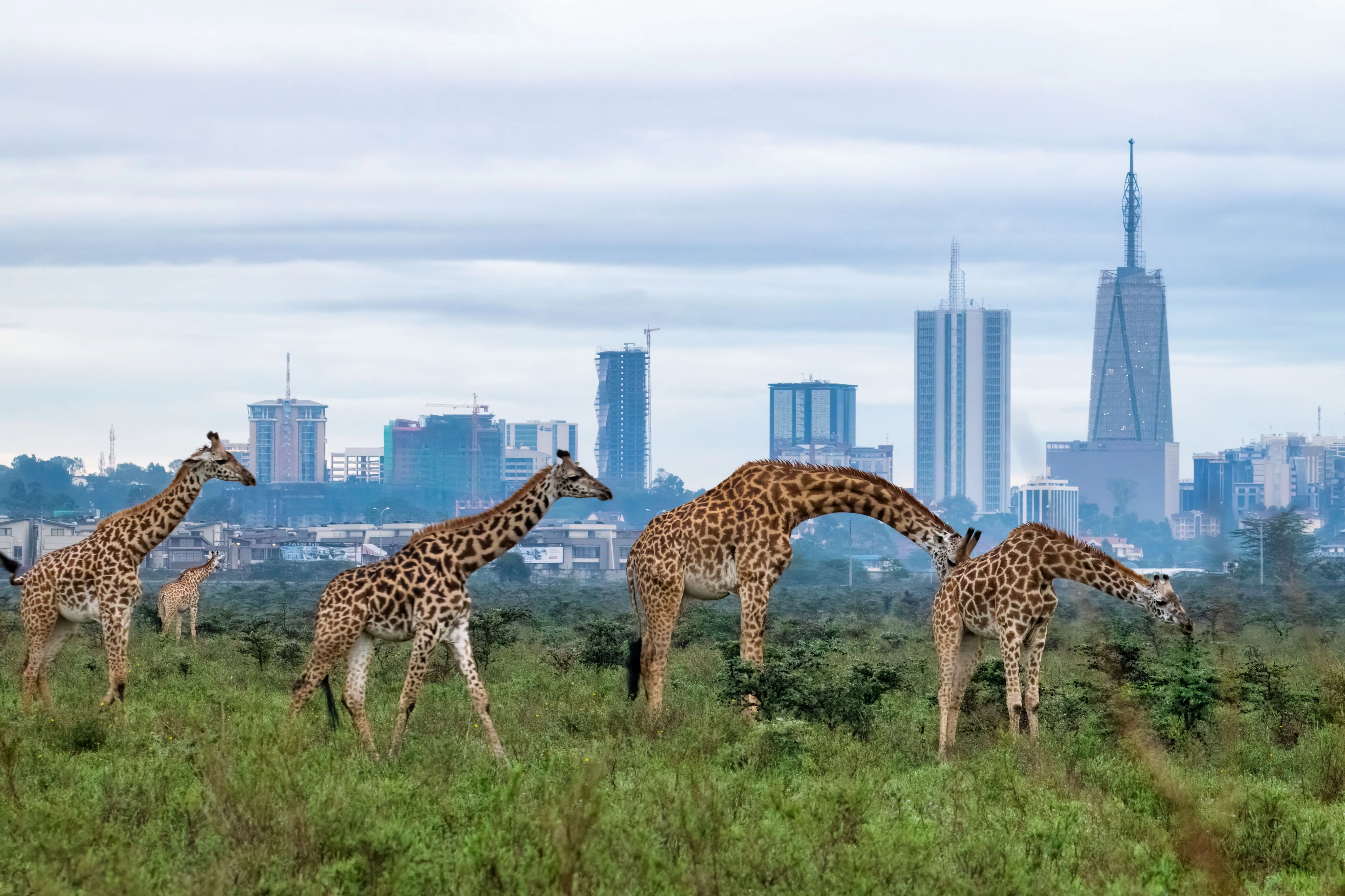
内罗毕国家公园,是肯尼亚的一个国家公园,位于首都内罗毕以南7公里。该国家公园成立于1946年,是肯尼亚第一个国家公园。总面积117.21平方公里,海拔位于1,533米至1,760米之间。
内罗毕国家公园与内罗毕市区仅有栅栏相隔,在公园内甚至能看到市区的高楼。
国家公园内有非洲水牛,狒狒,黑犀牛、豹、狮子等野生动物。 一年中最适宜看野生动物的月份是五月。
Der Nairobi-Nationalpark ist Kenias erster Nationalpark und wurde 1946 eröffnet. Der Nationalpark beheimatet etwa 80 Säugetierarten sowie über 500 Vogelarten. Er ist eines der erfolgreichsten Schutzgebiete für Nashörner in Kenia.
Der Park ist nur etwa 7 km vom Stadtzentrum Nairobis, der Hauptstadt Kenias, entfernt. Die Skyline der Großstadt kann vom Park aus gesehen werden. Nur ein Zaun trennt die Tiere von der Stadt. Diese Nähe verursacht Konflikte mit der einheimischen Bevölkerung, vor allem weil es die Wanderrouten der Huftierherden gefährdet.
Im Jahr 1989 ließ der damalige Präsident Daniel arap Moi im Nairobi-Nationalpark öffentlich Elfenbein im Wert von 760.000 US-Dollar verbrennen, um ein Zeichen gegen Wilderei zu setzen. Noch heute erinnert ein Mahnmal an dieses Ereignis.
 International cities
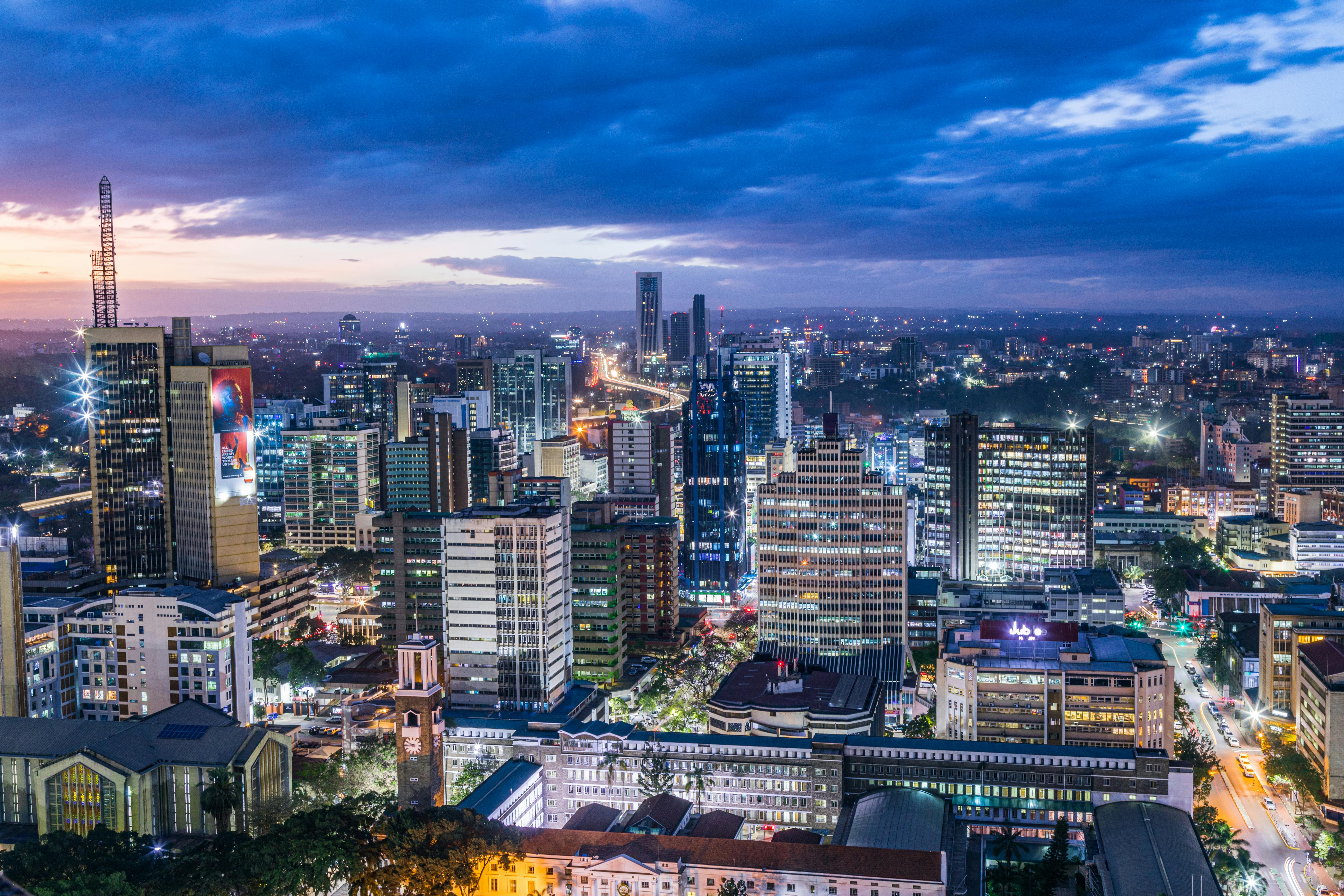

Nairobi [na͜iˈroːbi] ist die Hauptstadt Kenias mit 4.397.073 Einwohnern (Zensus im August 2019),[1][2] die auf einer Fläche von etwa 704 Quadratkilometern leben. Bis 2010 war Nairobi auch die Hauptstadt einer der acht Provinzen des Landes, heute liegt Nairobi im Nairobi County.
Der Name der Stadt kommt von dem Maa-Ausdruck Engare Nyarobie, was etwa „kühler Fluss“ bedeutet.
内罗毕(英语:Nairobi)是东非国家肯尼亚的首都,也是非洲的大城市之一。内罗毕的命名是由当地马赛族的话Enkare Nyirobi(“冰水”)而来的,冰水指的是流过内罗毕的内罗毕河。根据2019年普查的资料,内罗毕市域的人口有约440万人[1][2]。居民大多说英文与斯瓦希里语(非洲东部的代表性语言)。
内罗毕成立于1899年,一开始是乌干达铁路的补给站,负责肯尼亚南方城市蒙巴萨和乌干达之间的补给。1900年代时在突然爆发的瘟疫之后开始重建,当时英属东非殖民地开始兴建,内罗毕就变成了殖民者的重镇。因为其高海拔、温带气候以及水源充足等原因而受到重视[3]。1907年英属东非殖民地将内罗毕设为首都[4]。
肯尼亚于1963年独立后,继续将这里当成首都[5]。在肯尼亚建国初期,内罗毕是咖啡、苶及剑麻产业的中心[6][7]。内罗毕位在肯尼亚的南部中心地带,海拔1,795米(5,889英尺)。
内罗毕是许多国际组织总部的所在地,例如联合国人居署(UNHABITAT)、环境署(UNEP)的总部、联合国内罗毕办事处、国际民航组织(ICAO)的非洲东部、南部办事处都设于此市。内罗毕是成熟的商业中心以及文化中心。内罗毕证券交易所(NSE)是非洲最大的证券交易所之一,也是非洲历史第二的证券交易所。若以交易量来看,内罗毕证券交易所每日交易量100亿,在非洲排名第四。内罗毕也有自然生态保护区-内罗毕国家公园。内罗毕在2010年加入UNESCO的全球学习城市网络。
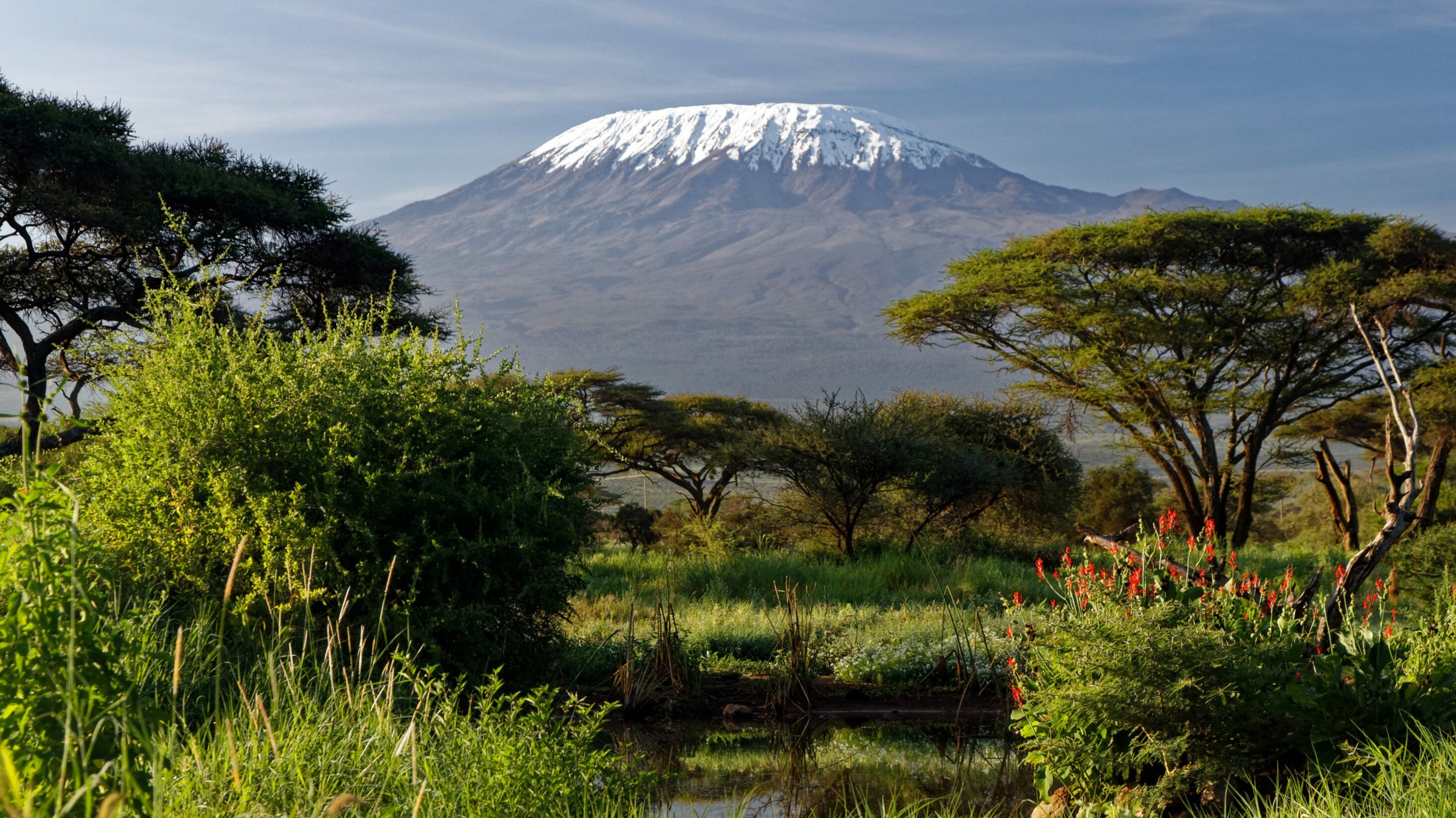
乞力马扎罗山(斯瓦希里语:Kilimanjaro,发音: /ˌkɪlɪmənˈdʒɑːroʊ/,又译克里曼加罗山,意为“灿烂发光的山”)位于坦桑尼亚东北的乞力马扎罗区,临近肯尼亚边界,是非洲的最高山,常被称为“非洲屋脊”、“非洲之王”[5]。其最高峰为基博峰(也称乌呼鲁峰),海拔5,895米(19,341英尺)[6][7]。乞力马扎罗山的部分山区被指定为乞力马扎罗国家公园,并登录为联合国世界遗产。
Der Kilimandscharo (auch Kilimandscharo-Massiv, von 1902 bis 1964 Kaiser-Wilhelm-Spitze oder auch Wilhelmskuppe, englisch Kilimanjaro oder Mount Kilimanjaro)[1] ist ein Bergmassiv im Nordosten Tansanias. Der höchste Berg des Massivs ist mit 5895 m Höhe der Kibo. Der Kibo ist der höchste Berg Afrikas und gehört damit zu den Seven Summits, den jeweils höchsten Bergen der sieben Kontinente.
Im Jahr 1987 wurde die Landschaft von der UNESCO zum Weltnaturerbe erklärt.[2] Bereits seit 1973 gibt es den Kilimandscharo-Nationalpark. Die Eiskappe des Kilimandscharo ist stark und in zunehmendem Maße von der globalen Erwärmung betroffen: So hat sich zwischen 1912 und 2020 die Eisschicht bereits um 85 Prozent verringert und wird bis 2030 voraussichtlich vollends verschwunden sein.
 Eat and Drink

Das ostafrikanische Land grenzt zwischen Somalia und Tansania an den Indischen Ozean und bedeckt eine Fläche von 580.367 km² (Rang 49).
Das Klima reicht von tropisch entlang der Küste bis hin zu wüstenhaft im Landesinneren.
Niedrig gelegene Ebenen steigen zum zentralen Hochland an, das durch den Ostafrikanischen Grabenbruch geteilt wird. Im Westen befindet sich eine fruchtbare Hochebene. Den höchsten Punkt markiert der zweithöchste Berg Afrika´s, der Mount Kenya (5.199m), der teilweise von Gletschern bedeckt ist.
Das kenianische Hochland umfasst eines der ertragreichsten landwirtschaftlichen Anbaugebiete Afrika´s.
*Mediterranean Sea
Egypt
 Ancient Egypt
Ethiopia
Burundi
Demokratische Republik Kongo
Kenya
Republic of the Sudan
Republik Südsudan
Ruanda
Tansania
Uganda
Ancient Egypt
Ethiopia
Burundi
Demokratische Republik Kongo
Kenya
Republic of the Sudan
Republik Südsudan
Ruanda
Tansania
Uganda

尼罗河(英语:Nile,阿拉伯语:النيل,埃及语:Ḥ'pī / iteru,科普特语:ⲫⲓⲁⲣⲟ / phiaro)是一条流经非洲东部与北部的河流,与中非地区的刚果河以及西非地区的尼日尔河并列非洲最大的四个河流系统。尼罗河长6650千米,是世界上第一长的河流[2]。2007年虽有来自巴西的学者宣称亚马逊河长度更胜一筹,但尚未获全球地理学界的普遍认同[3]。尼罗河有两条主要的支流,白尼罗河和蓝尼罗河。发源于埃塞俄比亚高原的青尼罗河是尼罗河下游大多数水和营养来源,但白尼罗河则是两条支流中最长的。它源于非洲中部的大湖地区,其最远的源头位于卢旺达( 2°16′55.92″S 29°19′52.32″E / 2.2822000°S 29.3312000°E),向北它流经坦桑尼亚并注入维多利亚湖,再从此湖中溢出注入艾伯特湖,往北流入乌干达和苏丹共和国南部,并于后者处形成大面积沼泽湿地。蓝尼罗河源于埃塞俄比亚的塔纳湖(12°2′8.8″N 37°15′53.11″E / 12.035778°N 37.2647528°E),从东南流入苏丹。在苏丹首都喀土穆附近,白尼罗河蓝尼罗河相汇,形成尼罗河。
尼罗河从苏丹首都向北穿过苏丹和埃及,所经过的地方均是沙漠。从古代开始埃及的文明就依靠尼罗河而形成和兴旺。除海港和海岸附近的城市外埃及所有的城市和大多数居民住在阿斯旺以北的尼罗河畔,几乎所有的古埃及遗址均位于尼罗河畔。 在其入海口尼罗河形成一个巨大的三角洲,在这里它注入地中海。
一般にはヴィクトリア湖を源流だとする約5,760kmの大河だと思われているが、ヴィクトリア湖には多数の流入河川が存在し、一方でヴィクトリア湖からの流出河川はナイル川しか存在しないため、ヴィクトリア湖をナイル川水系に含み、そこに流れ込む河川の長さもナイル川の長さに加算するのが普通である。ヴィクトリア湖に流れ込む河川のうちで最大最長のものは、ルワンダに源を持ち、ルワンダとブルンジやタンザニアの国境をなし、さらにタンザニアとウガンダの国境をなした後タンザニアのブコバ市北方でヴィクトリア湖に流れ込むカゲラ川である。そのカゲラ川の支流のうちでもっとも長いものは、ブルンジ南部のブルリ県を水源とするルヴィロンザ川(Ruvyironza)であり、これがナイル川の最上流であるとされる。
ヴィクトリア湖(標高1134m)は赤道直下のサバナ気候であり、降水量も多い。ヴィクトリア湖から下流はヴィクトリアナイルとも呼ばれその長さは約5,760kmである。ヴィクトリア湖からのナイル川の流出口は湖北部のジンジャであり、流出口には記念碑が建てられているほか、オーエン・フォールズ・ダムが建設され、発電をおこなっている。ヴィクトリア湖から約500km下流に行くとキオガ湖を経て、120mの高さのあるマーチソン・フォールズをとおり、アルバート湖(標高619m)に着く[1]。アルバート湖には、ほかにもウガンダ南西部のジョージ湖からカジンガ水路、エドワード湖を通って流れてきたセムリキ川が注いでいる。アルバート湖からはアルバートナイルとも呼ばれる。南スーダンに入り、急流を一つ越えると首都ジュバである。ジュバからは勾配が非常に緩やかとなり、少し北のモンガラ市周辺からはスッドの影響を受けるようになる。支流のバハル・エル=ガザル川(Bahr el Ghazal)とノ湖で合流し、そこからは白ナイル川とよばれる。このあたりはスッドと呼ばれる大湿原となっており、ここで蒸発して流量が激減する。帆船時代はここは複雑な流路と生い茂る水草によって南北の交通を阻む障壁となってきたが、蒸気船の登場以後は航路が設定されるようになった。さらに、スッドの出口であるマラカル市の南でソバト川を合わせる。マラカルからハルツームまでの800kmの標高差は12mにすぎず、非常に緩やかな流れとなる[2]。
白ナイル川はスーダンのハルツームで、エチオピアのタナ湖から流れてくる青ナイル川と合流する。ハルツームを過ぎて80kmほどで、ナイル川には再び急流が出現する。これは北から数えて6番目の急流のため、第6急流と呼ばれる。ここからエジプトのアスワンまでの間にある6つの急流は、エジプトとスーダンの間の舟運を拒み、交通の障害となってきた。しかし、この急流の区間は古くからエジプトの影響を受け、ヌビアと呼ばれて独自の古代王国を築いていた。第6急流の北、200kmほどのところには古代のクシュ王国の都であったメロエ(Meroë)がある。さらにその北、ハルツームから約300km下流のアトバラで支流のアトバラ川と合流する。これ以北は完全な砂漠気候であり、ナイル河谷を除いてほとんど人は住まなくなる。また、これ以北ではナイルに注ぎ込む常時水流のある支流は存在せず、わずかに降水時に水の流れるワジが点在するのみとなる。第4急流付近には、メロエ以前にクシュの首都であったナパタ(ゲベル・バルカル)がある。この付近に2009年メロウェダム(Merowe Dam)が完成し、大規模な発電を開始した。エジプトに入ると、アスワン・ハイ・ダムとそれによって出来たナセル湖がある。ナセル湖の長さは550kmに及び、その南端はスーダン最北の町ワジハルファを越えさらに南まで延びている。アスワン以北は古くからの「エジプト」であり、幅5kmほどのナイル河谷に人が集住するようになる。アスワンからカイロまでは上エジプトと呼ばれる。この区間ではナイル川はほぼ一本の河川であるが、北西へと流れる支流があり、カイロ南西にファイユーム・オアシスを作ってカルーン湖に注ぎ込む。それからさらに北へ流れ、カイロから北は三角州が発達している。ナイル川三角州は下エジプトとも呼ばれる。三角州はアレクサンドリアからポートサイドまで約240kmの幅を持ち、東のロゼッタ支流と西のダミエッタ支流という二つの主流と多くの分流に別れ、地中海に注いでいる。
The Nile (Arabic: النيل, romanized: an-Nīl, Arabic pronunciation: [an'niːl], Bohairic Coptic: ⲫⲓⲁⲣⲟ Pronounced [pʰjaˈro][4], Nobiin: Áman Dawū[5]) is a major north-flowing river in northeastern Africa, and is the longest river in Africa and the disputed longest river in the world,[6][7] as the Brazilian government says that the Amazon River is longer than the Nile.[8][9] The Nile is about 6,650 km (4,130 mi)[n 1] long and its drainage basin covers eleven countries: Tanzania, Uganda, Rwanda, Burundi, the Democratic Republic of the Congo, Kenya, Ethiopia, Eritrea, South Sudan, Republic of the Sudan, and Egypt.[11] In particular, the Nile is the primary water source of Egypt and Sudan.[12]
The Nile has two major tributaries – the White Nile and the Blue Nile. The White Nile is considered to be the headwaters and primary stream of the Nile itself. The Blue Nile, however, is the source of most of the water, containing 80% of the water and silt. The White Nile is longer and rises in the Great Lakes region of central Africa, with the most distant source still undetermined but located in either Rwanda or Burundi. It flows north through Tanzania, Lake Victoria, Uganda and South Sudan. The Blue Nile begins at Lake Tana in Ethiopia[13] and flows into Sudan from the southeast. The two rivers meet just north of the Sudanese capital of Khartoum.[14]
The northern section of the river flows north almost entirely through the Sudanese desert to Egypt, then ends in a large delta and flows into the Mediterranean Sea. Egyptian civilization and Sudanese kingdoms have depended on the river since ancient times. Most of the population and cities of Egypt lie along those parts of the Nile valley north of Aswan, and nearly all the cultural and historical sites of Ancient Egypt are found along river banks.
Le Nil (prononcé [nil]) est un fleuve d'Afrique. Avec une longueur d'environ 6 700 km, c'est avec le fleuve Amazone, le plus long fleuve du mondenotes 1. Il est issu de la rencontre du Nil Blanc et du Nil Bleu. Le Nil blanc (Nahr-el-Abiad) prend sa source au lac Victoria (Ouganda, Kenya, Tanzanie) ; le Nil bleu (Nahr-el-Azrak) est issu du lac Tana (Éthiopie). Ses deux branches s'unissant à Khartoum, capitale du Soudan actuel, le Nil se jette dans la Méditerranée en formant un delta au nord de l'Égypte. En comptant ses deux branches, le Nil traverse le Rwanda, le Burundi, la Tanzanie, l'Ouganda, l'Éthiopie, le Soudan du Sud, le Soudan et l'Égypte. Il longe également le Kenya et la République démocratique du Congo (respectivement avec les lacs Victoria et Albert), et son bassin versant concerne aussi l'Érythrée grâce à son affluent du Tekezé.
Le Nil est la voie qu'empruntaient les Égyptiens pour se déplacer. Il apporte la vie en fertilisant la terre et garantit l'abondance. Il joua un rôle très important dans l'Égypte antique, du point de vue économique, social (c'était autour de lui que se trouvaient les plus grandes villes), agricole (grâce au précieux limon des crues) et religieux. Fleuve nourricier de cette civilisation, il fut divinisé sous le nom d'Hâpynotes 2, personnifiant la crue du Nil dans la mythologie égyptienne.
La crue du Nil, qui avait lieu chaque été et qui apportait le limon noir permettant la culture de ses rives, est restée longtemps un phénomène inexpliqué. C'est de ce limon noir que vient le nom antique de l'Égypte, Kemet, qui veut dire « la terre noire ».
De nos jours, les eaux limoneuses du Nil sont captées et redistribuées sur les terres agricoles grâce aux barrages de Ziftah, d'Assiout, d'Hammadi, d'Esna et surtout aux deux barrages géants d'Assouan, l'ancien et le grand barrage, dont la construction dans les années 1970 a nécessité le déplacement de plusieurs temples dont ceux d'Abou Simbel, qui auraient été noyés dans la retenue du lac Nasser.
Il Nilo (in arabo: نهر النيل, Nahr al-Nīl) è un fiume africano lungo 6 852 Km. Tradizionalmente considerato il fiume più lungo del mondo, contende il primato della lunghezza al Rio delle Amazzoni.[1]
Possiede due grandi affluenti, il Nilo Bianco e il Nilo Azzurro; quest'ultimo contribuisce con un maggior apporto di acqua e di limo fertile, ma il primo è il più lungo. Il Nilo Bianco nasce convenzionalmente dal Lago Vittoria a Jinja in Uganda, ma le sue fonti si spingono fino al Ruanda ed al Burundi; scorre poi verso nord in Uganda e in Sudan meridionale. Il Nilo Azzurro invece nasce convenzionalmente dal Lago Tana in Etiopia, e scorre attraverso il Sudan sud-orientale. I due fiumi s'incontrano e si fondono presso la capitale sudanese Khartum.
La sezione settentrionale del fiume scorre quasi interamente attraverso il Sahara, dal Sudan all'Egitto, un paese la cui civiltà è dipesa dal fiume fin dai tempi antichi e più remoti. La maggior parte della popolazione egiziana e tutte le sue città (con l'eccezione di quelle situate lungo la costa) si trovano lungo la valle del Nilo a nord di Assuan, e quasi tutti i siti storici e culturali dell'Antico Egitto si trovano lungo le sponde del fiume.
Alla fine il Nilo si dirama in un grande delta e sfocia nel Mar Mediterraneo.
Dalle sorgenti al delta il Nilo attraversa sette paesi africani: Burundi, Ruanda, Tanzania, Uganda, Sudan del Sud, Sudan ed Egitto, ma il suo bacino idrografico include porzioni della Repubblica Democratica del Congo, Kenya, Etiopia ed Eritrea.
El río Nilo (en árabe: النيل, alnayl) es el mayor río de África, que fluye en dirección norte a través de diez países —Burundi, Ruanda, Tanzania, Uganda, Kenia, República Democrática del Congo, Sudán del Sur, Sudán, Egipto y Etiopía— hasta desaguar en el extremo sureste del mar Mediterráneo, formando el gran delta del Nilo, sobre el que están situadas las ciudades de El Cairo y Alejandría. Tiene una longitud de 6853 km, el segundo río más largo del mundo, tras el Amazonas.
Durante siglos fue considerado el río más largo del mundo;2 sin embargo, mediciones de los años 2007 y 2008 han redefinido el nacimiento del Amazonas en la cuenca del río Apurimac al sur del Perú, designándolo como el río más largo del mundo.34
La fuente más lejana del lago Victoria es el río Kagera, localizado al oeste de Tanzania. Si se considera este como fuente del Nilo, su nacimiento sería el curso de agua más largo de los que desembocan en el Mediterráneo, siendo el Nilo-Kagera el segundo río más largo del mundo, con una longitud de 6853 kilómetros.5
El Nilo tomó su actual configuración al final de la Era Terciaria. Está ubicado al nordeste del continente. Nace en Burundi y tiene dos ramales o fuentes principales: el Nilo Blanco y el Nilo Azul. El primero atraviesa los Grandes Lagos de África, teniendo su fuente más distante en Ruanda, y fluye hacia el norte por Tanzania, el lago Victoria, Uganda, Sudán del Sur y Sudán, mientras que el Nilo Azul nace en el lago Tana, en Etiopía, y cruza el sudeste de Sudán. Ambos se encuentran cerca de la capital sudanesa, Jartum.
La parte del norte del río fluye casi completamente por el desierto, entre Sudán y Egipto, una zona cuya civilización ha dependido del río desde hace milenios. La mayor parte de la población de Egipto y todas sus ciudades —a excepción de las del delta del Nilo y los oasis— se encuentran a lo largo del valle del Nilo (al norte de Asuán), y la mayoría de los lugares de interés cultural e histórico se hallan en las riberas del río. La desembocadura del río conforma el delta del Nilo, a orillas del mar Mediterráneo.
Нил (араб. النيل, Эн-Ниль[1]; англ. Nile, егип. jtrw Ятрау или ḥꜥpj Хапи, копт. Ⲫⲓⲁⲣⲟ (p(h)iaro)) — река в Африке, одна из величайших по протяжённости речных систем в мире. Слово «Нил» происходит от греческого названия реки «Нейлос» (Νεῖλος).
Река берёт начало на Восточно-Африканском плоскогорье и впадает в Средиземное море, образуя дельту площадью 24 тыс. км²[2]. Среднегодовой расход воды в устье Нила 2900 м³/сек[3]. В верхнем течении принимает крупные притоки — Эль-Газаль (левый) и Асуа, Собат, Голубой Нил и Атбара (правые). Ниже устья правого притока Атбары Нил течёт по полупустыне, не имея притоков на протяжении последних 3000 км[4].
Водная система Нила считается самой длинной на Земле[5]. Однако, по мнению бразильских исследователей, самая длинная речная система у Амазонки — по этим данным, её длина составляет 6992 километра, в то время как длина системы Нила — 6852 километра[6]. Площадь бассейна реки Нил составляет 3349 тыс. км²[5]. Исток находится в Руанде, это река Рукарара, впадающая в реку Кагера. Сток воды сильно и резко изменяется в течение года. Суммарная длина судоходных участков составляет 3,2 тыс. км. Воды реки используются для орошения и производства электроэнергии. В дельте и долине Нила проживает почти все население и базируется почти вся экономика Египта. Крупнейшими городами являются Каир, Хартум, Асуан, Александрия[2].
 Sport
Sport
 *UK political system
Antigua and Barbuda
Australia
Bahamas
Bangladesh
Barbados
Belize
Botsuana
Brunei Darussalam
Commonwealth of Nations
Dominica
*UK political system
Antigua and Barbuda
Australia
Bahamas
Bangladesh
Barbados
Belize
Botsuana
Brunei Darussalam
Commonwealth of Nations
Dominica
 History
M 1500 - 2000 AD
History of the United Kingdom
Ghana
Grenada
Guyana
India
Jamaika
Cameroon
Canada
Kenya
Kiribati
Lesotho
Malawi
Malaysia
Malediven
Malta
Mosambik
Namibia
Nauru
New Zealand
Nigeria
Pakistan
Papua-Neuguinea
Salomonen
Sambia
Samoa
Seychellen
Sierra Leone
Singapore
Sri Lanka
Saint Kitts and Nevis
St. Vincent and the Grenadines
South Africa
Swasiland
Tansania
Tonga
Trinidad und Tobago
Tuvalu
Uganda
Vanuatu
United Kingdom
Important International Organizations
Cyprus
History
History
M 1500 - 2000 AD
History of the United Kingdom
Ghana
Grenada
Guyana
India
Jamaika
Cameroon
Canada
Kenya
Kiribati
Lesotho
Malawi
Malaysia
Malediven
Malta
Mosambik
Namibia
Nauru
New Zealand
Nigeria
Pakistan
Papua-Neuguinea
Salomonen
Sambia
Samoa
Seychellen
Sierra Leone
Singapore
Sri Lanka
Saint Kitts and Nevis
St. Vincent and the Grenadines
South Africa
Swasiland
Tansania
Tonga
Trinidad und Tobago
Tuvalu
Uganda
Vanuatu
United Kingdom
Important International Organizations
Cyprus
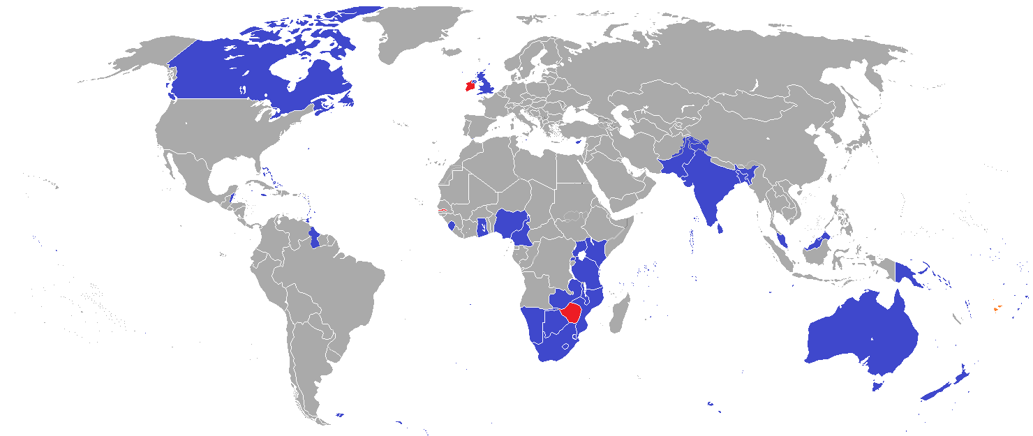
英联邦(英语:Commonwealth of Nations,新马作共和联邦,台湾作大英国协),是一个现代的国际组织,由56个英语系的主权国家联合而成。
英联邦不是一个统一的联邦国家,而是一个国际组织,英联邦也无权约束旗下任何成员国内政。英联邦元首通常由英国君主兼任,其首任元首是乔治六世,现任是查尔斯三世,但元首并无实权,秘书长才是英联邦实际上的掌权者[4][5]。该组织的成员国基本由英国及其旧殖民地组成,也以英式英语为共通语言,但英国的地位并没有凌驾于他国之上,所有成员国一律平等。目前英联邦有56个成员国,其中15个属于英联邦王国,英联邦王国的国家元首、英联邦元首均和英国的一致,即现在的查尔斯三世;另外5个属于独立君主国,它们不以英国君主为自己的元首,而是自立君主,这五国是文莱、斯威士兰、莱索托、马来西亚、汤加;其余的36个均属于共和国,没有君主。
The Commonwealth of Nations, generally known simply as the Commonwealth,[3] is a political association of 53 member states, nearly all of them former territories of the British Empire.[4] The chief institutions of the organisation are the Commonwealth Secretariat, which focuses on intergovernmental aspects, and the Commonwealth Foundation, which focuses on non-governmental relations between member states.[5]
The Commonwealth dates back to the first half of the 20th century with the decolonisation of the British Empire through increased self-governance of its territories. It was originally created as the British Commonwealth of Nations[6] through the Balfour Declaration at the 1926 Imperial Conference, and formalised by the United Kingdom through the Statute of Westminster in 1931. The current Commonwealth of Nations was formally constituted by the London Declaration in 1949, which modernised the community and established the member states as "free and equal".[7]
The human symbol of this free association is the Head of the Commonwealth, currently Queen Elizabeth II, and the 2018 Commonwealth Heads of Government Meeting appointed Charles, Prince of Wales to be her designated successor, although the position is not technically hereditary. The Queen is the head of state of 16 member states, known as the Commonwealth realms, while 32 other members are republics and five others have different monarchs.
Member states have no legal obligations to one another, but are connected through their use of the English language and historical ties. Their stated shared values of democracy, human rights and the rule of law are enshrined in the Commonwealth Charter[8] and promoted by the quadrennial Commonwealth Games.
The countries of the Commonwealth cover more than 29,958,050 km2 (11,566,870 sq mi), equivalent to 20% of the world's land area, and span all six inhabited continents.
Le Commonwealth ou Commonwealth of Nations (littéralement, la « Communauté des Nations ») est une organisation intergouvernementale composée de 53 États membres qui sont presque tous d'anciens territoires de l'Empire britannique.
Le Commonwealth a émergé au milieu du XXe siècle pendant le processus de décolonisation. Il est formellement constitué par la Déclaration de Londres de 1949 qui fait des États membres des partenaires « libres et égaux ». Le symbole de cette libre association est la reine Élisabeth II qui est chef du Commonwealth. La reine est également le chef d'État monarchique des 16 royaumes du Commonwealth. Les autres États membres sont 32 républiques et cinq monarchies dont le monarque est différent.
Les États membres n'ont aucune obligation les uns envers les autres. Ils sont réunis par la langue, l'histoire et la culture et des valeurs décrites dans la Charte du Commonwealth telles que la démocratie, les droits humains et l'état de droit.
Les États du Commonwealth couvrent 29 958 050 km2 de territoire sur les cinq continents habités. Sa population est estimée à 2,328 milliards d'habitants.
Il Commonwealth delle Nazioni o Commonwealth (acronimo CN) è un'organizzazione intergovernativa di 53 Stati membri indipendenti, tutti accomunati, eccetto il Mozambico e il Ruanda, da un passato storico di appartenenza all'Impero britannico, del quale il Commonwealth è una sorta di sviluppo su base volontaria. La popolazione complessiva degli stati che vi aderiscono è di oltre due miliardi di persone. La parola Commonwealth deriva dall'unione di common (comune) e wealth (benessere), cioè benessere comune.
In passato fu noto anche come Commonwealth britannico, benché tale definizione esistette formalmente solo dalla fondazione nel 1926 fino al 1948.
La Mancomunidad de Naciones (en inglés: Commonwealth of Nations)?, antiguamente Mancomunidad Británica de Naciones (British Commonwealth of Nations), es una organización compuesta por 53 países soberanos independientes y semi independientes que, con la excepción de Mozambique y Ruanda,1 comparten lazos históricos con el Reino Unido. Su principal objetivo es la cooperación internacional en el ámbito político y económico, y desde 1950 la pertenencia a ella no implica sumisión alguna a la Corona británica, aunque se respeta la figura de la reina del Reino Unido. Con el ingreso de Mozambique, la organización ha favorecido el término Mancomunidad de Naciones para subrayar su carácter internacionalista. Sin embargo, el adjetivo británico se sigue utilizando con frecuencia para diferenciarla de otras mancomunidades existentes a nivel internacional.
La reina Isabel II del Reino Unido es la cabeza de la organización, según los principios de la Mancomunidad, «símbolo de la libre asociación de sus miembros».
Содру́жество на́ций (англ. Commonwealth of Nations, до 1946 года — Британское Содружество наций — англ. British Commonwealth of Nations), кратко именуемое просто Содружество (англ. The Commonwealth) — добровольное объединение суверенных государств, в которое входят Великобритания и почти все её бывшие доминионы, колонии и протектораты. Членами Содружества также являются Мозамбик, Руанда, Намибия и Камерун[2].