
漢德百科全書 | 汉德百科全书
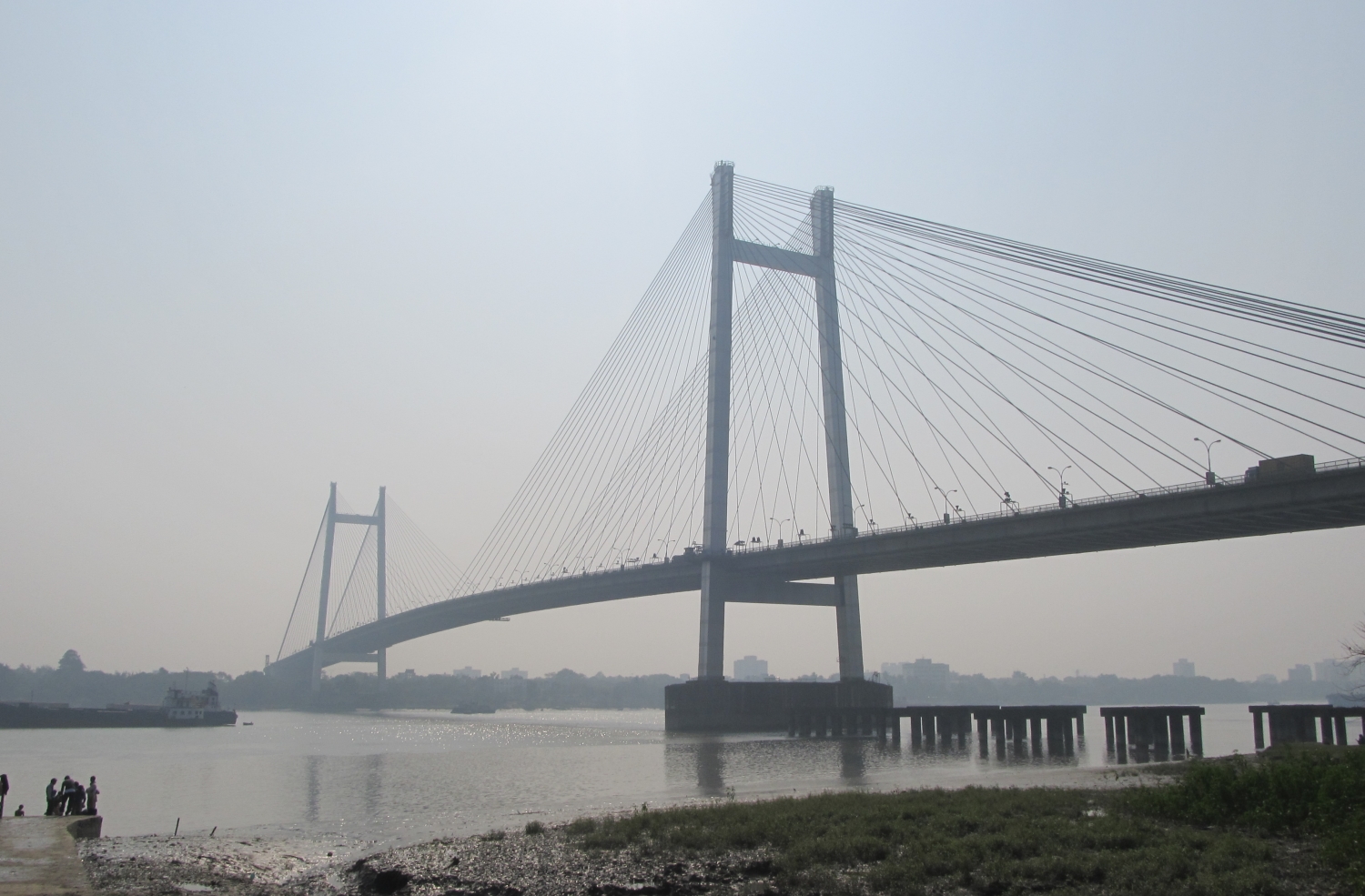
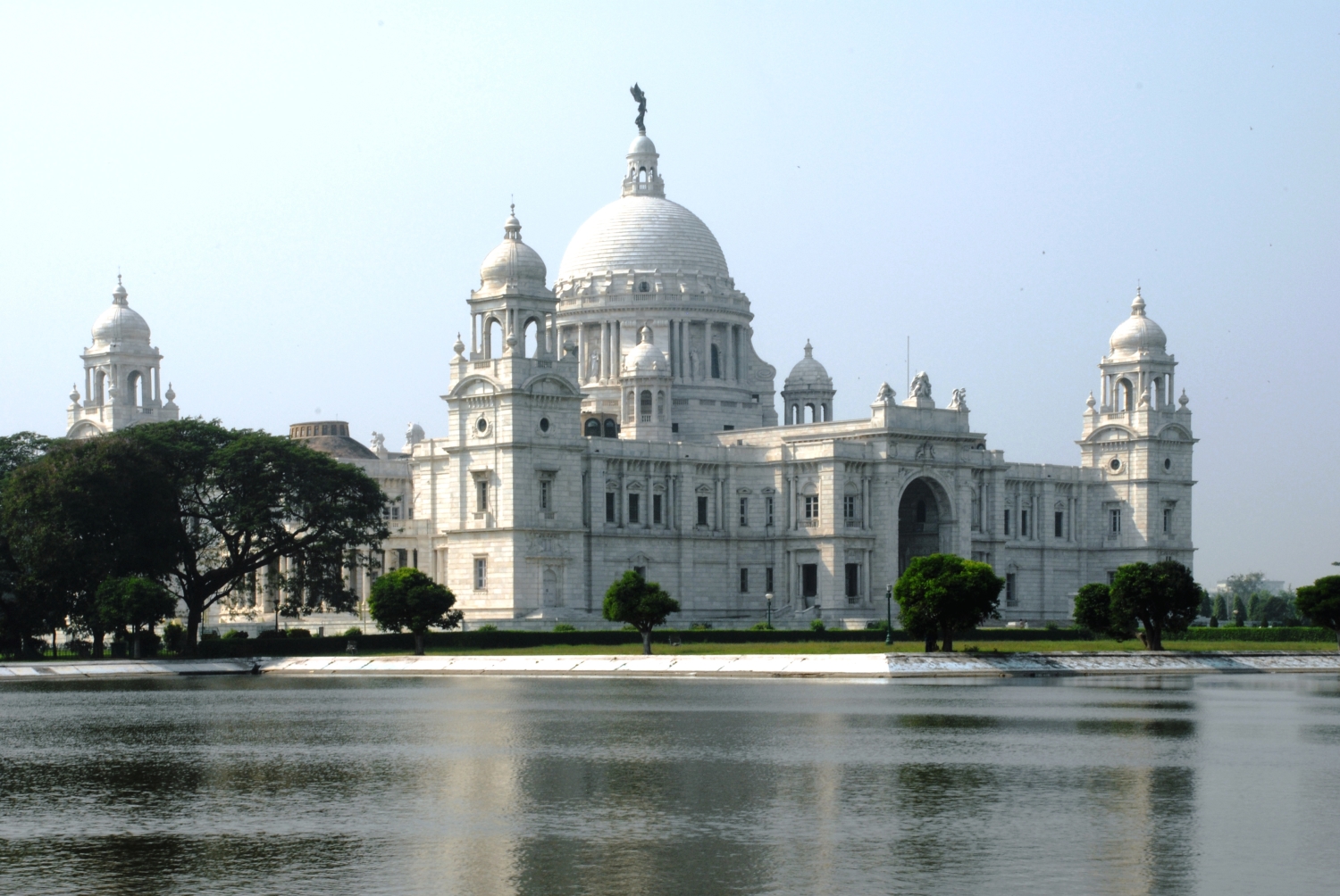
 India
India
 Companies

 IT-Times

 Architecture

 Bahrain
 Hand in Hand
Hand in Hand
Hand in Hand
 Institute of Culture and Language
India
Katar
National Capital Territory
Oman
Saudi Arabia
Uttar Pradesh
United Arab Emirates
Institute of Culture and Language
India
Katar
National Capital Territory
Oman
Saudi Arabia
Uttar Pradesh
United Arab Emirates

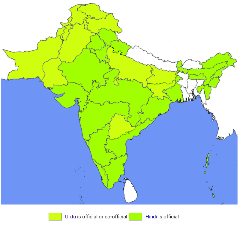
Urdu (anhörenⓘ/?) (persisch: اردو DMG urdū; kurz für زبان اردو معلہ DMG zabān-i urdū-yi muʿalla, deutsch ‚Sprache des königlichen Lagers‘)[1] ist eine indoarische Sprache und gehört zum indoiranischen Zweig der indogermanischen Sprachfamilie. Die Bezeichnung „Urdu“ tauchte erstmals im Jahr 1780 in den Gedichten von Ghulam Hamdani Mushafi auf. Ältere und heute weniger gebräuchliche indigene Namen waren لشکری Laschkarī, abgekürzt von لشکری زبان laschkarī zubān, deutsch ‚Armeesprache‘, کھڑی بولی kharī bolī, deutsch ‚stehende / etablierte Sprache‘ oder einfach ہندوی Hindavī, deutsch ‚indisch‘.
乌尔都语(乌尔都语:اُردُو)是属于印欧语系印度-伊朗语族的印度-雅利安语支。从使用人数来看,乌尔都语大约排名世界第20名,是巴基斯坦的国语,也是印度的24种规定语言之一。如果从宏观角度来看,乌尔都语可看成是印度斯坦语的一部分,所有印度斯坦语言构成世界上第四大的语言。在1200年到1800年,南亚在德里苏丹国和莫卧儿帝国的统治下,乌尔都语受到波斯语、突厥语、库尔德语和阿拉伯语的影响。
 Animal world
 Geography
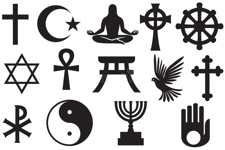 Religion

Die Sikh-Religion (Panjabi: ਸਿੱਖੀ, sikhī) ist eine im 15. Jahrhundert entstandene monotheistische Religion, die auf den Wanderprediger Guru Nanak zurückgeht. Die im Punjab (Nord-Indien) begründete Reformbewegung – im deutschen Sprachraum auch als Sikhismus bezeichnet – hat heute rund 23 Millionen Anhänger, wovon die Mehrzahl in Indien lebt.
Wesentliche Merkmale der Sikh-Religion sind die Betonung der Einheit der Schöpfung, die Abkehr von „Aberglauben“, traditionellen religiösen Riten und sozialer Hierarchisierung nach Religion, Herkunft und Geschlecht. Es existieren jedoch verschiedene formale Vorgaben z. B. bezüglich Kleidung, Namensgebung und Auftreten. Die Sikh-Religion orientiert sich nicht an der Einhaltung religiöser Dogmen, sondern hat das Ziel, religiöse Weisheit für den Alltag nutzbar zu machen. Guru Nanak sowie seine neun nachfolgenden Gurus (religiöse Vorbilder) unterstreichen in ihren Einsichten, die schriftlich in dem Werk Guru Granth Sahib überliefert sind, ihr Verständnis, über vorhandene Religionen hinauszugehen, und distanzieren sich inhaltlich von den dominierenden religiösen Traditionen ihres Zeitalters, darunter Buddhismus, Hinduismus und Islam.
锡克教(旁遮普语:ਸਿੱਖੀ,旁遮普语转写:sikkhī,发音:旁遮普语发音:[ˈsɪkːʰiː],英语:Sikhism ,意为“信徒”)是一种发源自印度的一神宗教,以《古鲁·格兰特·萨希卜》为经典。锡克教在15世纪末发源自旁遮普地区,是现存最年轻的主流宗教之一,目前在全世界有2600万教徒,[1]是世界第六大宗教。约有2300万锡克教徒生活在印度,其中大部分居住在旁遮普邦,其在加拿大、美国和英国也有较多数量的信徒分布。

Über 80 Prozent der rund 25 bis 27 Millionen[2] Sikhs (wörtlich Schüler) leben in der indischen Ursprungsregion: in den Bundesstaaten Punjab und Haryana sowie in den Unionsterritorien Delhi und Chandigarh. Von diesen knapp 19 Millionen indischen Sikhs leben 75 Prozent im Bundesstaat Punjab. In Indien bilden Sikhs mit rund zwei Prozent Bevölkerungsanteil die viertgrößte Religionsgemeinschaft des Landes.
In Kanada (rund 770.000 (Stand 2021)[3]), Großbritannien (rund 230.000) sowie in südostasiatischen Staaten, vor allem in Malaysia, Singapur und Thailand, leben zusammengenommen mehr als eine Million Sikhs. In Deutschland leben über 25.000 Sikhs,[4] vor allem in Ballungszentren wie Frankfurt am Main, Köln, Hamburg, München und Stuttgart. In Österreich lebten 2001 knapp 2.800 Sikhs;[5] für 2021 werden sie nicht eigens ausgewiesen.[6] In der Schweiz sind keine genauen Zahlen bekannt, die Zahl wird auf etwa 1000 geschätzt.[7] Zurzeit gibt es in der deutschsprachigen Schweiz drei Gurdwaras[8] (Gebets- und Schulstätten), in Genf ist ein Gurdwara im Entstehen.[9][10] In Frankreich leben etwa 10.000 Sikhs, fast alle im Großraum Paris[11]. In Italien wird ihre Zahl auf etwa 40.000 bis 70.000 geschätzt, vor allem in den Regionen Lombardei und Emilia-Romagna, wo sie eine wichtige Rolle bei der Herstellung von Parmesan spielen.[12] Im Gegensatz zu Großbritannien, Kanada und den USA, wo Sikhs weithin bekannt sind und auch wichtige staatliche Ämter bekleiden, sind sie in Mitteleuropa aufgrund ihrer relativ geringen Zahl eher unbekannt. In Essen kam es 2016 zu einem Sprengstoffanschlag durch zwei als salafistisch eingestufte Jugendliche auf das Gebetshaus der Sikh-Gemeinde Gurdwara Nanaksar.
| 主要分布地区 | |
|---|---|
| 23,000,000[1] | |
| 770,000[2] | |
| 500,000–700,000[3][4][5] | |
| 432,429[6][7][8] | |
| 150,000[9] | |
| 125,900[10] | |
| 120,000[11] | |
| 70,000[12] | |
| 50,000[13] | |
| 50,000[14] | |
| 50,000[15][16] | |
| 40,908[17] | |
| 10,000–20,000[18] | |
| 15,000[19] | |
| 10.000[20] | |
| 10,000[21] | |
| 5,000[22] | |
| 2,577[23] | |
 Afghanistan
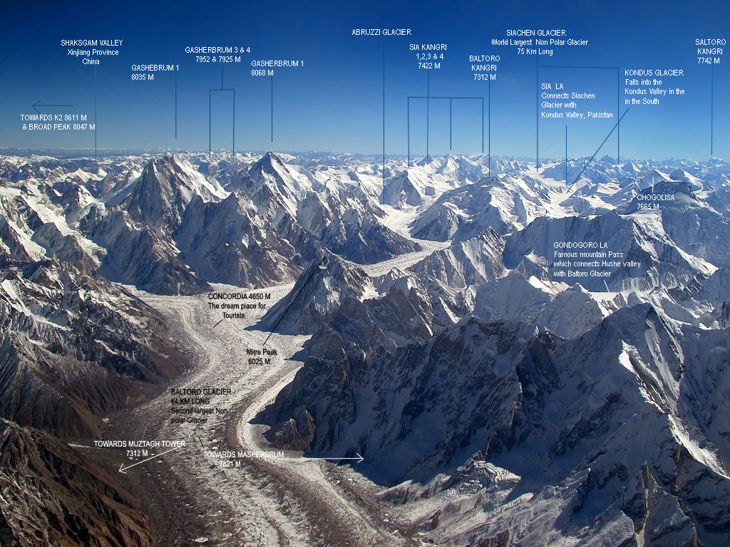
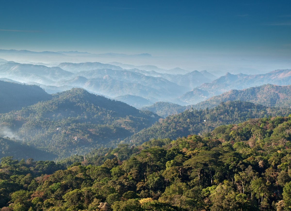
Der Himalaya (auch Himalaja) (Sanskrit: हिमालय, himālaya, deutsch [hiˈmaːlaɪ̯a] oder [himaˈlaɪ̯a]; von hima ‚Schnee‘ und alaya „Ort, Wohnsitz“) ist ein Hochgebirgssystem in Asien. Es ist das höchste Gebirge der Erde und liegt zwischen dem indischen Subkontinent im Süden und dem Tibetischen Hochland im Norden. Das Gebirge erstreckt sich auf einer Länge von etwa 3000 Kilometern von Pakistan bis Myanmar (Burma) und erreicht eine Breite von bis zu 350 Kilometern. Im Himalaya befinden sich zehn der vierzehn Berge der Erde, deren Gipfel mehr als 8000 Meter hoch sind („Achttausender“), darunter der Mount Everest, der mit 8848 m ü. NHN höchste Berg der Erde. Mit seiner südlichen Lage sowie dem sich im Rückraum des Himalaya als ausgedehntes Hochplateau erhebenden Tibetischen Hochland übt der Himalaya großen Einfluss auf das Klima Süd- und Südostasiens aus. So wird der Indische Sommermonsun erst durch die im Sommer thermisch bedingten Ferrel'schen Druckgebilde in Westindien und Tibet erzeugt. An der Haupterhebung des Himalaya gestaut, liegen hier einige der regenreichsten Orte der Erde sowie die Quellgebiete aller großen Flusssysteme Südasiens.
喜马拉雅山脉(梵语:हिमालय IAST:hīmalaya,“雪(hīma)域(laya)”之意[1];藏文:ཧི་མ་ལ་ཡ,藏语拼音:himalaya,威利:hi ma la ya;尼泊尔语:हिमालय)是世界海拔最高的山脉,位于亚洲的中国西藏自治区与巴基斯坦、印度、尼泊尔、不丹等国边境上。东西长2400多公里,南北宽200至300公里[2]。分布于青藏高原南缘,西起克什米尔的南迦-帕尔巴特峰(北纬35°14'21",东经74°35'24",海拔8125米),东至雅鲁藏布江大拐弯处的南迦巴瓦峰(北纬29°37'51",东经95°03'31",海拔7756米),总面积约594,400平方公里[1]。
中国与尼泊尔边界上的主峰珠穆朗玛峰海拔高度8844.43米,为世界第一高峰。喜马拉雅山脉中还有一百多座高度超过7200米的山峰,而喜马拉雅山脉以外的最高峰是世界第二高峰、位于喀喇昆仑山脉的乔戈里峰,高度8611米。喜马拉雅山脉对南亚文化有许多的影响,许多山脉中的高山是佛教及印度教的圣地。
喜马拉雅山脉也有一些较低而走势平行的山麓,第一山麓在最南边,高约一千米,称为西瓦利克山脉,再往北即是高二千到三千米的小喜马拉雅山带。
喜马拉雅山脉横跨了五个国家:印度、尼泊尔、不丹、中国及巴基斯坦,喜马拉雅山脉主要是在前三个国家的国境内[3]。喜马拉雅山脉的西北方是兴都库什山脉和喀喇昆仑山脉,北边是西藏高原,南边则是印度河-恒河平原。
世界上的主要河川中,印度河、恒河及雅鲁藏布江(下游是布拉马普特拉河)都是发源自喜马拉雅山脉。印度河和雅鲁藏布江发源自冈仁波齐峰附近,而恒河发源自印度的北阿坎德邦。这些河的流域中居住约六亿人。
ヒマラヤ山脈(ヒマラヤさんみゃく、Himalayan Range)は、アジアの山脈で、地球上で最も標高の高い地域である。単にヒマラヤということもある。
ヒマラヤは、インド亜大陸とチベット高原を隔てている無数の山脈から構成される巨大な山脈である。西はパキスタン北部インダス川上流域から、東はブラマプトラ川大屈曲部まで続き、ブータン、中国、インド、ネパール、パキスタンの5つの国にまたがる。いずれも最大級の大河であるインダス川、ガンジス川、ブラマプトラ川、黄河、長江の水源となって数々の古代文明を育み、このヒマラヤ水系には約7億5千万人の人々が生活している(これにはバングラデシュの全人口が含まれる)。ヒマラヤは、広義の意味ではユーラシアプレートとインド・オーストラリアプレートの衝突によって形成された周辺の山脈である、カラコルム山脈、ヒンドゥークシュ山脈、天山山脈、崑崙山脈などを含む。
広義のヒマラヤには、最高峰エベレストを含む、地球上で最も高い14の8,000 m級ピークがあり、7,200 m以上の山が100峰以上存在する。一方で、アジアのこの地域以外には7,000 m以上の山は存在せず、アンデス山脈アコンカグアの6,961 mが最高標高である。以下では狭義のヒマラヤについて解説する。
The Himalayas, or Himalaya (/ˌhɪməˈleɪə, hɪˈmɑːləjə/), form a mountain range in Asia, separating the plains of the Indian subcontinent from the Tibetan Plateau.
The Himalayan range has many of the Earth's highest peaks, including the highest, Mount Everest. The Himalayas include over fifty mountains exceeding 7,200 m (23,600 ft) in elevation, including ten of the fourteen 8,000-metre peaks. By contrast, the highest peak outside Asia (Aconcagua, in the Andes) is 6,961 m (22,838 ft) tall.[1]
Lifted by the subduction of the Indian tectonic plate under the Eurasian Plate, the Himalayan mountain range runs west-northwest to east-southeast in an arc 2,400 km (1,500 mi) long.[2] Its western anchor, Nanga Parbat, lies just south of the northernmost bend of Indus river. Its eastern anchor, Namcha Barwa, is just west of the great bend of the Yarlung Tsangpo River (upper stream of the Brahmaputra River). The Himalayan range is bordered on the northwest by the Karakoram and the Hindu Kush ranges. To the north, the chain is separated from the Tibetan Plateau by a 50–60 km (31–37 mi) wide tectonic valley called the Indus-Tsangpo Suture.[3] Towards the south the arc of the Himalaya is ringed by the very low Indo-Gangetic Plain.[4] The range varies in width from 350 km (220 mi) in the west (Pakistan) to 150 km (93 mi) in the east (Arunachal Pradesh).[5] The Himalayas are distinct from the other great ranges of central Asia, although sometimes the term 'Himalaya' (or 'Greater Himalaya') is loosely used to include the Karakoram and some of the other ranges.
The Himalayas are inhabited by 52.7 million people,[5] and are spread across five countries: Nepal, India, Bhutan, China and Pakistan. Some of the world's major rivers — the Indus, the Ganges and the Tsangpo-Brahmaputra — rise in the Himalayas, and their combined drainage basin is home to roughly 600 million people. The Himalayas have a profound effect on the climate of the region, helping to keep the monsoon rains on the Indian plain and limiting rainfall on the Tibetan plateau. The Himalayas have profoundly shaped the cultures of the Indian subcontinent; many Himalayan peaks are sacred in Hinduism and Buddhism.
L'Himalaya Écouter (sanskrit : हिमालय de hima (neige) et ālaya (demeure), littéralement « demeure des neiges »1, népalais : हिमालय, hindi : हिमालय, ourdou : ہمالیہ), ou chaîne de l'Himalaya, est un ensemble de chaînes de montagnes s'étirant sur plus de 2 400 km de long et large de 250 à 400 km, qui sépare le sous-continent indien du plateau tibétain dans le Sud de l'Asie. Au sens strict, il débute à l'ouest au Nanga Parbat au Pakistan et se termine à l'est au Namche Barwa au Tibet. Cet ensemble montagneux, délimité à l'ouest par la vallée du fleuve Indus et à l'est par la vallée du fleuve Brahmapoutre, couvre une aire d'environ 600 000 km2.
Ainsi, l'Himalaya abrite 10 des 14 sommets qui culminent à plus de 8 000 mètres d'altitude, dont le mont Everest, le plus haut de tous ; les 4 autres se situent dans le Karakoram. Ces hauts sommets ont donné lieu à de nombreuses expéditions d'alpinistes renommés et ont tous été conquis.
La limite supérieure des forêts se situe à 3 900 m et la limite inférieure des neiges éternelles vers 5 000 m2.
L'Himalaya fait partie d'un ensemble montagneux plus vaste encore que l'on désigne par « Aire Hindu Kush-Himalaya » (HKH), laquelle comprend les chaînes du Karakoram, de l'Hindou Kouch et du Pamir. Ce vaste ensemble chevauche huit pays et abrite plus de 140 millions de personnes.
L'Himalaya o Himalaia (pron. /imaˈlaja/, tradizionalmente /iˈmalaja/[1]; in sanscrito हिमालय, "dimora delle nevi", dall'unione di hima, "neve", e ālaya, "dimora"), adattata talvolta in italiano come Imalaia[2][3][4], è un sistema montuoso dell'Asia centrale, il cui nome significa «dimora delle nevi»[5], che si innalza a settentrione del bassopiano Indo-gangetico, e a meridione dell'altopiano del Tibet e che forma un gigantesco arco diretto da nord-ovest a sud-est con la convessità rivolta a sud e compreso all'incirca tra 73° e 95° di long. est e 27° e 36° di lat. nord.
Entro i limiti convenzionali, segnati a nord dalle valli superiori dell'Indo e dell'alto Brahmaputra (o Sang-po), a est e a ovest dalle valli degli stessi fiumi, che con brusco cambiamento di direzione scendono da nord verso sud, e a sud dal margine della pianura, il sistema himalayano si sviluppa per una lunghezza di 2200 km su una larghezza variante da 250 a 350 km. Si tratta di rilievi che hanno la stessa età geologica delle Alpi e rappresentano un sistema a pieghe perfettamente analogo a quello alpino per struttura e per paesaggio, però di ben maggiori proporzioni, soprattutto altimetriche[6].
El Himalaya (del sánscrito हिमालय, himālaya [pr. jimaalaia], donde hima, "nieve", y ālaya, "morada", "lugar") es una cordillera situada en el continente asiático, y se extiende por varios países: Bután, Nepal, China e India.
Es la cordillera más alta de la Tierra, con más de cien cimas que superan los 7000 metros y nueve cimas de más de 8000 metros de altura, entre las cuales se halla el Monte Everest, de 8848 msnm, la montaña más alta del planeta sobre el nivel del mar.
Forma parte de un complejo orográfico mayor: el sistema de los Himalayas, un conjunto compuesto por las cordilleras del Himalaya, Karakórum, donde se encuentran los restantes cinco "ochomiles", Hindú Kush y diversas otras subcordilleras que se extienden a partir del Nudo del Pamir y sus subcordilleras adyacentes.
En el Himalaya nacen algunos de los mayores ríos del mundo: el río Ganges, el río Indo, el río Brahmaputra, río Yamuna y el río Yangtsé, en cuyos cauces viven no menos de 1300 millones de personas. Las montañas del Himalaya han influido profundamente sobre las culturas de Asia del Sur, y muchas de ellas son sagradas para el hinduismo y para el budismo.
Гимала́и (санскр. हिमालयः, himālayaḥ IAST «обитель снегов», хинди हिमालय, непальск. हिमालय, тиб. ཧི་མ་ལ་ཡ, кит. упр. 喜马拉雅山脉, кит. упр. 雪域山脉, урду ہمالیہ, англ. Himalayas) — высочайшая горная система Земли. Гималаи расположены между Тибетским нагорьем (на севере) и Индо-Гангской равниной (на юге)[2]. Резко выражен климатический и природный рубеж между горными пустынями Центральной Азии и тропическими ландшафтами Южной Азии.
Гималаи раскинулись на территории Индии, Непала, Тибетского автономного района Китая, Пакистана и Бутана. Предгорья Гималаев также занимают крайнюю северную часть Бангладеш[3].
Горная система Гималаев на стыке Центральной и Южной Азии имеет свыше 2900 км в длину и около 350 км в ширину. Площадь составляет приблизительно 650 тыс. км²[2]. Средняя высота гребней около 6 км, максимальная 8848 м[4] — гора Джомолунгма (Эверест). Здесь находится 10 восьмитысячников — вершин высотой более 8000 м над уровнем моря. На северо-западе от западной цепи Гималаев находится другая высочайшая горная система — Каракорум.
Население в основном занимается земледелием, хотя климат позволяет выращивать лишь несколько видов злаков, картофель и некоторые другие овощи. Поля расположены на наклонных террасах.
 History
Bangladesh
China
Guangdong Sheng-GD
India
Indonesia
Iran
Malaysia
Nepal
Netherlands
Pakistan
Portugal
Spain
Sri Lanka
Turkey
History
Bangladesh
China
Guangdong Sheng-GD
India
Indonesia
Iran
Malaysia
Nepal
Netherlands
Pakistan
Portugal
Spain
Sri Lanka
Turkey
 Veneto
United Kingdom
Veneto
United Kingdom
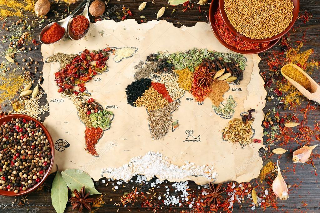
香料贸易在人类历史上有着举足轻重的作用,尤其是中世纪的欧洲,对香料的渴望直接催生了地理大发现。从遥远的东方运送香辛料到欧洲的贸易线路被称为香料之路。香料作为当时最贵重的商品之一,其价值几与黄金相当。英语中“Spice”(香辛料)这个词来源于拉丁语“species”,常用来指代贵重但量小的物品。
在16世纪,葡萄牙统治了东印度的香料贸易,17世纪的霸主是荷兰,而18世纪则是英国。而在16~19世纪初,中国大陆是世界上最大的香料市场,东南亚大部分香料都销往这里;而荷兰、英国、美国等国商人,就由广州运载中国香料返国,广州成为早期东南亚香料的集散中心[1]。
Der Gewürzhandel umfasste historische Zivilisationen in Asien, Nordostafrika und Europa. Gewürze wie Zimt, Kassia, Kardamom, Ingwer, Pfeffer, Muskatnuss, Sternanis, Nelken und Kurkuma waren bereits in der Antike bekannt und wurden in der östlichen Welt gehandelt. Diese Gewürze fanden ihren Weg in den Nahen Osten noch vor Beginn der christlichen Zeitrechnung, wobei fantastische Geschichten ihre wahre Herkunft verschleierten.
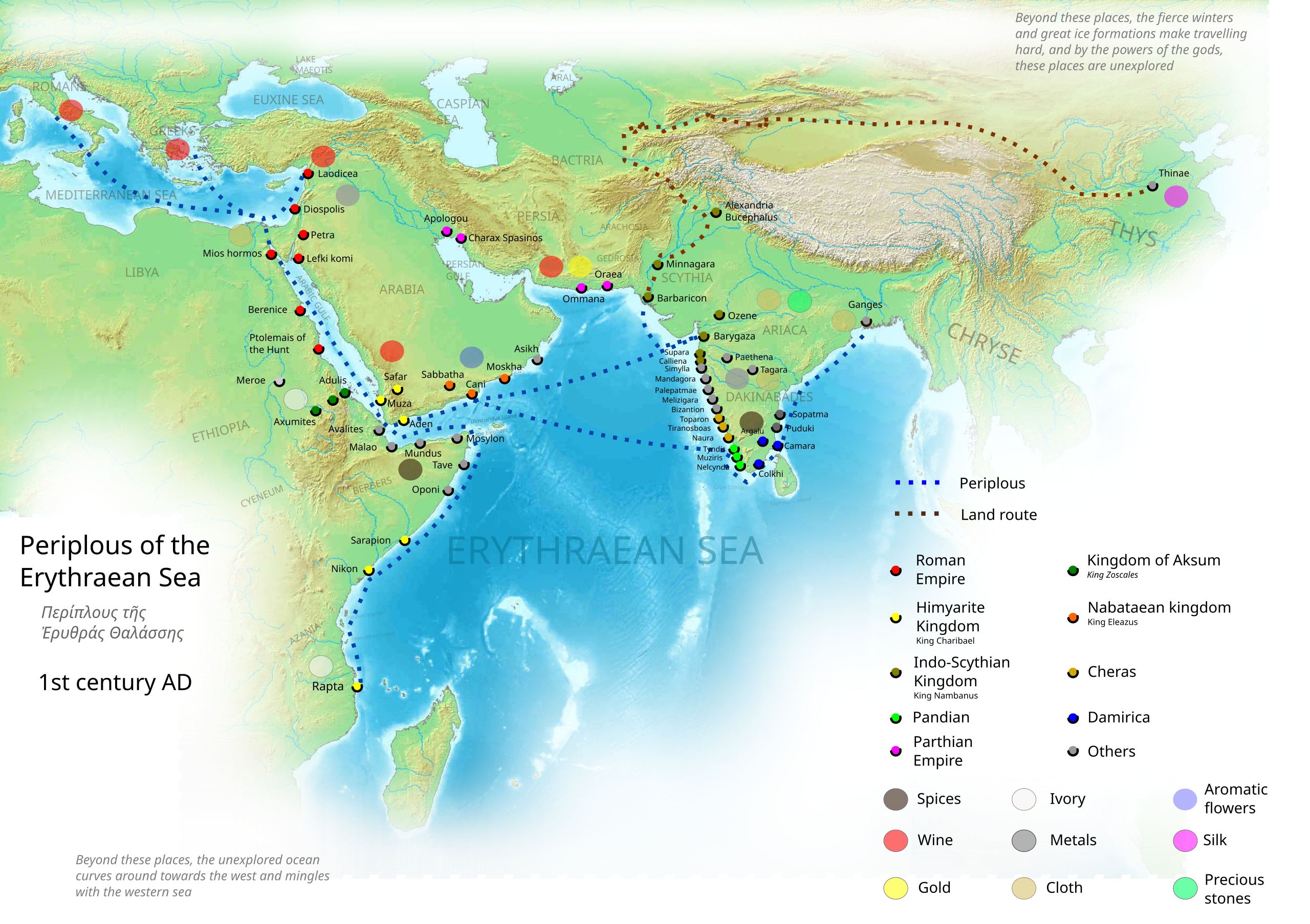
Der maritime Aspekt des Handels wurde von den austronesischen Völkern in Südostasien dominiert, nämlich den alten indonesischen Seefahrern, die bis 1500 v. Chr. Routen von Südostasien nach Sri Lanka und Indien (und später nach China) etablierten. [2] Diese Waren wurden dann von indischen und persischen Händlern über die Weihrauchroute und die römisch-indischen Routen auf dem Landweg zum Mittelmeer und in die griechisch-römische Welt transportiert. Die maritimen Handelswege der Austronesier dehnten sich später bis ins 1. Jahrtausend n. Chr. auf den Nahen Osten und Ostafrika aus, was zur austronesischen Kolonisierung Madagaskars führte.
The spice trade involved historical civilizations in Asia, Northeast Africa and Europe. Spices, such as cinnamon, cassia, cardamom, ginger, pepper, nutmeg, star anise, clove, and turmeric, were known and used in antiquity and traded in the Eastern World.[1] These spices found their way into the Near East before the beginning of the Christian era, with fantastic tales hiding their true sources.[1]
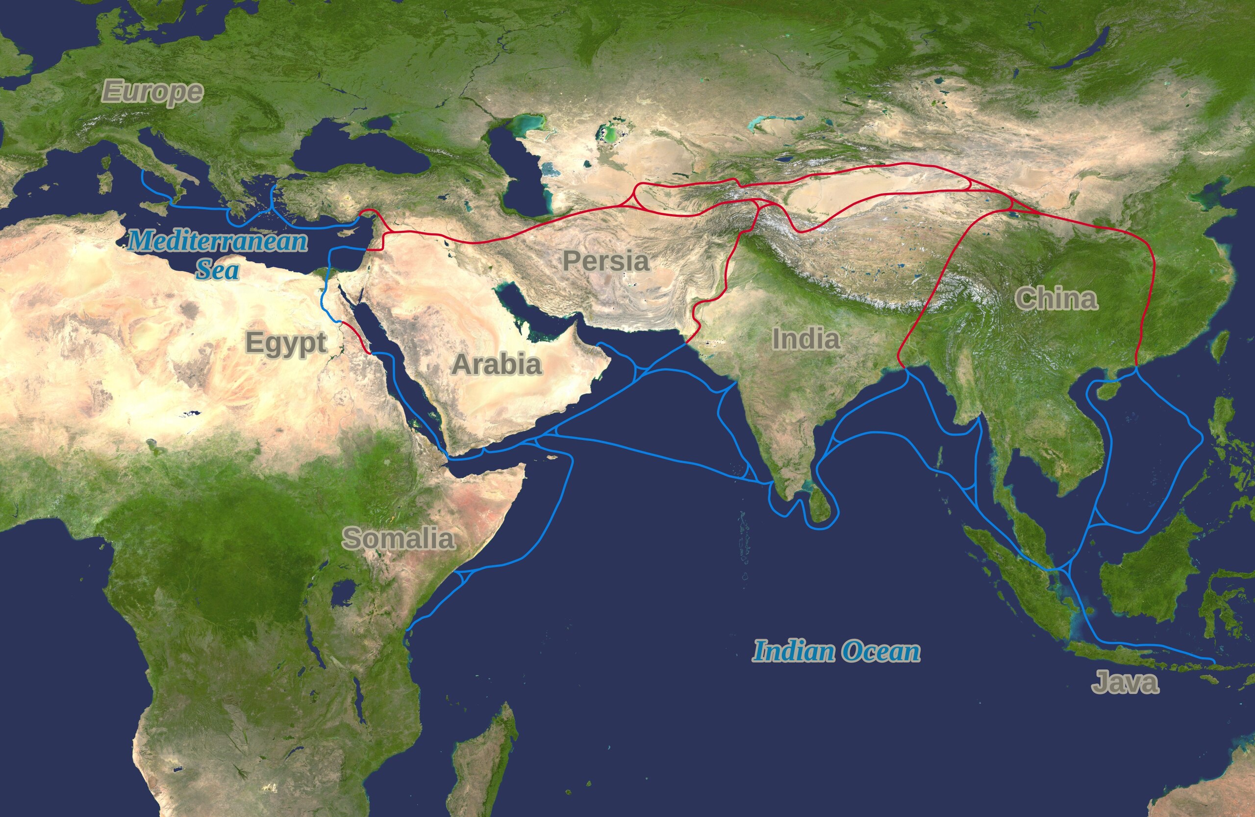
The maritime aspect of the trade was dominated by the Austronesian peoples in Southeast Asia, namely the ancient Indonesian sailors who established routes from Southeast Asia to Sri Lanka and India (and later China) by 1500 BC.[2] These goods were then transported by land toward the Mediterranean and the Greco-Roman world via the incense route and the Roman–India routes by Indian and Persian traders.[3] The Austronesian maritime trade lanes later expanded into the Middle East and eastern Africa by the 1st millennium AD, resulting in the Austronesian colonization of Madagascar.
Within specific regions, the Kingdom of Axum (5th century BC – 11th century AD) had pioneered the Red Sea route before the 1st century AD. During the first millennium AD, Ethiopians became the maritime trading power of the Red Sea. By this period, trade routes existed from Sri Lanka (the Roman Taprobane) and India, which had acquired maritime technology from early Austronesian contact. By the mid-7th century AD, after the rise of Islam, Arab traders started plying these maritime routes and dominated the western Indian Ocean maritime routes.[citation needed]
Arab traders eventually took over conveying goods via the Levant and Venetian merchants to Europe until the rise of the Seljuk Turks in 1090. Later the Ottoman Turks held the route again by 1453 respectively. Overland routes helped the spice trade initially, but maritime trade routes led to tremendous growth in commercial activities to Europe. [citation needed]
The trade was changed by the Crusades and later the European Age of Discovery,[4] during which the spice trade, particularly in black pepper, became an influential activity for European traders.[5] From the 11th to the 15th centuries, the Italian maritime republics of Venice and Genoa monopolized the trade between Europe and Asia.[6] The Cape Route from Europe to the Indian Ocean via the Cape of Good Hope was pioneered by the Portuguese explorer navigator Vasco da Gama in 1498, resulting in new maritime routes for trade.[7]
This trade, which drove world trade from the end of the Middle Ages well into the Renaissance,[5] ushered in an age of European domination in the East.[7] Channels such as the Bay of Bengal served as bridges for cultural and commercial exchanges between diverse cultures[4] as nations struggled to gain control of the trade along the many spice routes.[1] In 1571 the Spanish opened the first trans-Pacific route between its territories of the Philippines and Mexico, served by the Manila Galleon. This trade route lasted until 1815. The Portuguese trade routes were mainly restricted and limited by the use of ancient routes, ports, and nations that were difficult to dominate. The Dutch were later able to bypass many of these problems by pioneering a direct ocean route from the Cape of Good Hope to the Sunda Strait in Indonesia.