
漢德百科全書 | 汉德百科全书
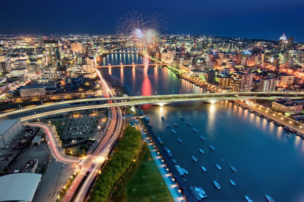
 2002年世界杯足球赛
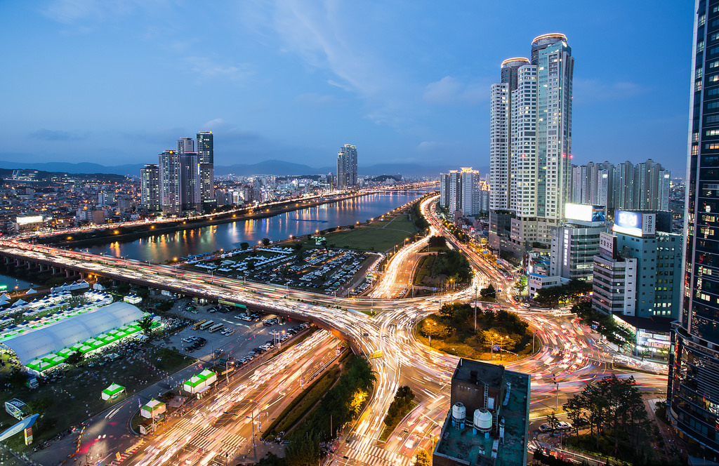
 国际城市
国际城市

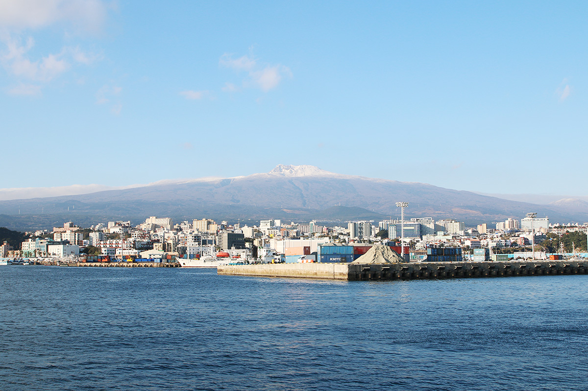
 重要港口
重要港口


Kōbe (jap. 神戸市, -shi) ist eine Großstadt in Japan auf der Insel Honshū. Die Stadt ist Sitz der Präfekturverwaltung von Hyōgo und hat einen der größten Seehäfen Japans. Die moderne, internationale Stadt bildet mit Osaka und Kyōto (Keihanshin) und kleineren Städten das Herz der Kansai-Gegend. Kōbe ist eine der ersten designierten Großstädte von 1956.
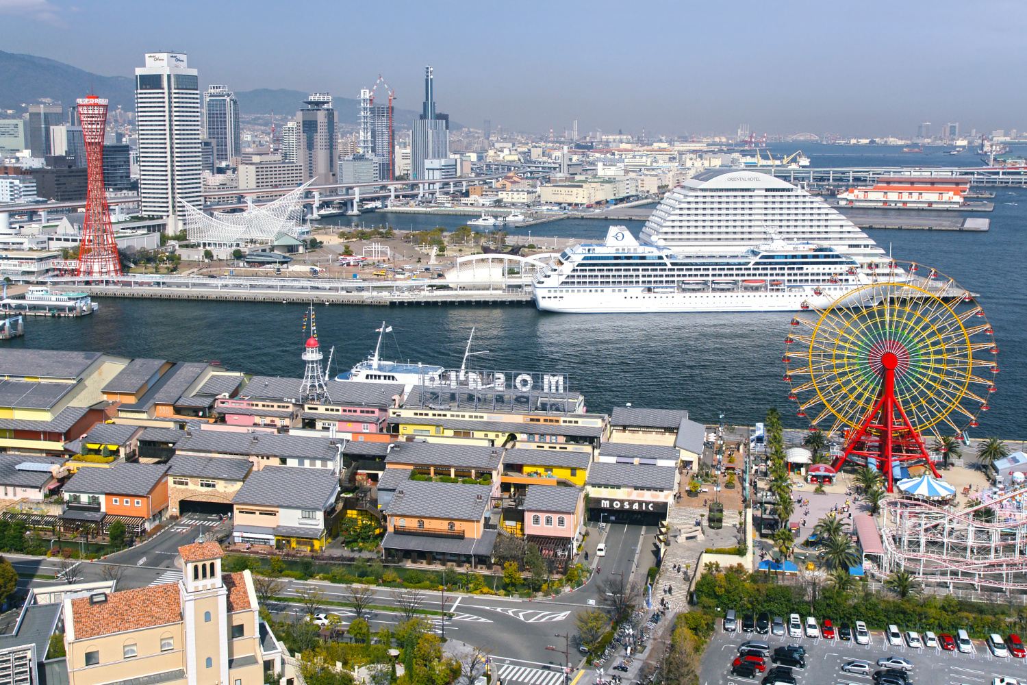
神户市(日语:神戸市/こうべし Kōbe shi */?)是位于日本兵库县东南部的都市,为兵库县首府,也是政令指定都市之一[1],下辖有9个区。神户市的面积为552.83平方公里。2016年6月,神户市有人口1,538,053人[2],是日本人口第七多的都市。神户市与大阪市、京都市并为京阪神都会区的核心都市[3],同时也和其附近的卫星都市组成神户都市圈[4]。
“神户”这一地名是起源于现在神户市中心的三宫、元町地区在古代曾是生田神社的领地,并居住有生田神社的神封户[5]。神户地处大阪湾沿岸,风浪平缓且沿岸水深较深,地形极为适宜建设港口[6]。在古代时期,神户就是京都及大阪的外港之一[7]。1868年,神户成为日本最早开放对外国通商的五个港口之一,之后神户迅速发展为日本最重要的港湾都市之一[8]。也正因其是日本最早的通商港口,神户以开放和国际化的气氛而闻名。1995年的阪神淡路大震灾虽然给神户带来巨大的打击,然而经过多年的重建,神户的都市建设和人口都已超过地震之前的水准[9]。神户也是一座宜居都市,并曾在2007年入选福布斯杂志评出的“世界最清洁的25座城市”[10],其后也于2012年在瑞士的咨询公司ECA国际评选出的世界宜居都市排名中排名第五位,是唯一入选前10位的日本都市[11]。
神戸市(こうべし)は、兵庫県の南部に位置する同県の県庁所在地。垂水区・須磨区・長田区・兵庫区・中央区・灘区・東灘区・北区・西区から構成される政令指定都市。日本の市で6番目の人口を有する。
海と山の迫る東西に細長い市街地を持ち、十分な水深のある扇状の入り江部に発展した理想的な港湾・神戸港を有する日本を代表する港町である。
「神戸」という地名は、現在の三宮・元町周辺が古くから生田神社の神封戸の集落(神戸「かんべ」)であったことに由来する。西国街道の宿場町であり北前船の出発地の一つでもあった兵庫津(ひょうごのつ)に近く、廻船問屋が軒を並べていた神戸村を指していた。神戸三社(神戸三大神社)をはじめとする市内・国内にある神社の神事に使うお神酒の生産にも係わり、前述の有馬温泉や神封戸の形成も市名の由来に関係している。
海運においても古くから盛んで、近代には世界の市場にその名を知られるほどに隆盛していった。以降も貿易・鉄鋼・造船・機械・製造・ゴム・真珠加工・観光等の産業を中心に発展、ファッション・医療・食料品などの産業も近年は盛んである。
1995年1月17日に発生した兵庫県南部地震による阪神・淡路大震災では市内のほぼ全域で震度7を観測。市街地と港、道路、インフラは甚大な被害を受けたが急速に復興を遂げ、2005年には国内3番目の市営空港として神戸空港が開港した。
2008年、アジアの都市で初めて「デザイン都市」としてユネスコに認定された。
2012年、スイスのECAインターナショナルが世界400余りの都市の、気候、医療サービス、インフラ、安全性、大気品質などの生活水準を調査し発表した「世界で最も住みやすい都市」で、日本の都市で唯一トップ10に入り、世界全体で5位、アジア圏ではシンガポールに次ぐ2位に選ばれている。
Kobe (神戸市 Kōbe-shi, Japanese: [koːꜜbe]) is the sixth-largest city in Japan and the capital city of Hyōgo Prefecture. It is located on the southern side of the main island of Honshū, on the north shore of Osaka Bay and about 30 km (19 mi) west of Osaka. With a population around 1.5 million, the city is part of the Keihanshin metropolitan area along with Osaka and Kyoto.[3]
The earliest written records regarding the region come from the Nihon Shoki, which describes the founding of the Ikuta Shrine by Empress Jingū in AD 201.[4][5] For most of its history, the area was never a single political entity, even during the Tokugawa period, when the port was controlled directly by the Tokugawa shogunate. Kobe did not exist in its current form until its founding in 1889. Its name comes from kanbe (神戸, an archaic title for supporters of the city's Ikuta Shrine).[6][7] Kobe became one of Japan's designated cities in 1956.
Kobe was one of the cities to open for trade with the West following the 1853 end of the policy of seclusion and has since been known as a cosmopolitan and nuclear-free zone port city. While the 1995 Great Hanshin earthquake diminished much of Kobe's prominence as a port city, it remains Japan's fourth-busiest container port.[8] Companies headquartered in Kobe include ASICS, Kawasaki Heavy Industries, and Kobe Steel, as well as over 100 international corporations with Asian or Japanese headquarters in the city, such as Eli Lilly and Company, Procter & Gamble, Boehringer Ingelheim, and Nestlé.[9][10] The city is the point of origin and namesake of Kobe beef, as well as the site of one of Japan's most famous hot spring resorts, Arima Onsen.
Kobe (神戸市, Kōbe-shi?, « Kōbe » signifiant « porte des esprits (ou des dieux) »), aussi Kobé, est la plus grande ville et la capitale de la préfecture de Hyōgo, située sur l'île de Honshū proche d'Osaka. La ville possède l'un des plus grands ports du Japon. Elle fait partie du Keihanshin.
Kōbe (神戸市 Kōbe-shi?) è una città del Giappone, di 1,5 milioni di abitanti, situata nell'isola di Honshū. Per circa sei mesi, nel 1180, fu la capitale del Giappone, quando l'imperatore Antoku si trasferì a Fukuhara kyō, che si trovava nell'odierno quartiere cittadino Hyōgo-ku.
Kōbe (神戸市 Kōbe-shi?, literalmente "Puerta de los dioses o espíritus") es una ciudad y municipio de Japón. Con una población de 1,5 millones de habitantes es la capital y ciudad más poblada de la prefectura de Hyōgo, y la sexta ciudad más poblada del país, por delante de Kioto. Se encuentra al sur de la isla de Honshū, en la orilla norte de la bahía de Osaka. Su término municipal se engloba en la región metropolitana de Keihanshin que, con una población de más de 19 millones de personas, constituye la segunda área metropolitana más poblada del país, sólo por detrás de Tokio. De acuerdo al Mercer Quality of Living Survey Kobe es una de las 50 ciudades con mejor calidad de vida del mundo y la tercera en Asia.3
Kobe es uno de los centros económicos más importantes de Japón. Más de cien compañías internacionales tienen su sede asiática o japonesa en la ciudad, como Nestlé, Boehringer Ingelheim, Eli Lilly and Company o Procter & Gamble. Su puerto es también uno de los más importantes de todo el país, aunque su relevancia disminuyó considerablemente tras los estragos del Gran Terremoto de Hanshin-Awaji que azotó a la ciudad en 1995. La ciudad es también lugar de origen y denominación de la ternera de Kobe.
Kobe posee un clima húmedo subtropical con veranos cálidos e inviernos fríos. Las precipitaciones son significativamente más abundantes en verano que en invierno, aunque en general son inferiores con respecto al resto de la isla.
Ко́бе (яп. 神戸市 Ко:бэ-си) — город, определённый указом правительства Японии, расположенный на острове Хонсю, административный центр префектуры Хиого. C VIII века Кобе является одним из главных портов Японии и центром международной торговли. Грузооборот порта около 150 млн тонн (1/3 внешнеторгового оборота страны). Кобе — крупный промышленный центр: здесь сосредоточена металлургия, машиностроение (1/3 тоннажа строящихся в Японии судов), военная, химическая, текстильная промышленность.
Исторически Кобе входил в состав провинции Идзуми и был важным транспортным и торговым пунктом на пути к японской столице Киото. В этом поселении традиционно находилось много контор оптовиков и ростовщиков, а также производителей японского рисового вина — саке. Кроме этого, Кобе было значительным религиозным центром и славился «тремя святынями», синтоистскими святилищами Икута, Нагата и Минатогава. С середины XIX века город стал одним из главных очагов модернизации страны, промышленности и производства искусственных жемчужин. Кобе потерпел страшные разрушения во время землетрясения 1995 года, но быстро восстановил свой потенциал.
 历史
历史
Seoul (kor. 서울, Aussprache: [sʌ.ul]  anhören?/i; siehe auch Namen Seouls) ist die Hauptstadt Südkoreas. Der amtliche koreanische Name lautet „Besondere Stadt Seoul“ (서울특별시, Seoul Teukbyeolsi). Diese Bezeichnung weist auf den Status als Hauptstadt und auf die verwaltungspolitische Gleichstellung gegenüber den Provinzen hin (siehe auch Verwaltungsgliederung Südkoreas).
Bereits 18 v. Chr. bis 475 war Seoul die historische Hauptstadt des Königreichs Baekje. Von 1394 bis 1910 war sie die Hauptstadt der Reiche Joseon und Groß-Korea. Zur Hauptstadt Südkoreas wurde sie im Jahr 1945 erhoben. Auch Nordkoreas Verfassung sah Seoul als rechtmäßige Hauptstadt vor, bis eine Verfassungsänderung von 1972 Pjöngjang zur Hauptstadt der Volksrepublik erhob, wo die nordkoreanische Führung seit Ende des Zweiten Weltkrieges einen provisorischen Regierungssitz eingerichtet hatte.
Die Einwohnerzahl von Seoul beträgt 10 Millionen (2015).[2] Die Stadt ist das Zentrum der Metropolregion Sudogwon (수도권, 首都圈), in der etwa 25,4 Millionen Menschen (2015) leben.[1] Damit konzentriert sich etwa die Hälfte aller Südkoreaner in der Stadt Seoul und deren Satellitenstädten. Sudogwon gilt als einer der fünf größten Ballungsräume der Welt und auch als viertgrößter Wirtschaftsraum der Welt.
Neben ihrem Status als Hauptstadt und bevölkerungsreichste Stadt Koreas ist Seoul zudem das Finanz-, Kultur- und Bildungszentrum Südkoreas. Die Stadt richtete die Olympischen Sommerspiele 1988 aus und war einer der Austragungsorte der Fußball-Weltmeisterschaft 2002.
首尔(朝鲜语:서울 Seoul */? 韩语发音 帮助·信息,官方英语拼法:Seoul,国际音标:[sʌ.ul]),正式名称为首尔特别市。旧中文译名为汉城,2005年更改译名为首尔,是大韩民国的首都和经济、科技、文化中心,亦是朝鲜半岛人口最多的城市。
首尔市位于朝鲜半岛中部,韩国西北部的汉江流域。首尔的位置最早为传疑时代的真番国,公元前18年,朝鲜三国时期的百济首先定都于此地,之后成为高丽王朝的南京。1394年,朝鲜国王李成桂迁都汉阳并改为汉城。第二次世界大战之后至亚洲金融危机,汉城经济快速恢复和发展,一度创造了汉江奇迹,并出现了三星、现代等大型跨国公司。2005年1月,汉城市政府宣布中文译名更改为“首尔”。截至2017年,首尔市人口达1千万,而以首尔市为核心的韩国首都圈总人口达2,400万[8]。
首尔曾举办1986年亚洲运动会、1988年夏季奥林匹克运动会、2002年世界杯足球赛等国际体育赛事与2010年二十国集团峰会等国际会议,曾获选为2010年世界设计之都[9][10]。
首尔市历史悠久,境内有昌德宫、宗庙、朝鲜王陵等3处世界文化遗产以及崇礼门等重要古迹。
ソウル特別市(ソウルとくべつし、韓国語: 서울특별시、英語:Seoul、通称ソウル)は、大韓民国(通称韓国)の首都。かつての朝鮮王朝の首都「漢城府」である。日本統治時代の朝鮮では漢ではなく京を使い「京城府」と呼ばれた。
もとは京畿道に属したが、1946年に分離し「特別市」となる。韓国にはソウル特別市のほか、世宗特別自治市と6つの広域市が存在し、日本の政令指定都市に相当するといえるが、特別市・特別自治市・広域市とも行政道には所属せず、道と同等の広域自治体として運営されている(特別市・広域市の領域では区が基礎自治体となっている)。
朝鮮王朝500年の王都で、四神相応の思想によって建てられた。「ソウル」とは朝鮮語で「都、首都」を意味し、語源については新羅語で首都を意味する「徐羅伐(ソラボル、서라벌)」が由来という説が有力である。なお「ソウル」は、漢字表記(漢城・漢陽・京城・京都など)の変遷に関わらず、朝鮮民族はこの地を「ソウル」と呼んできたとも言われている。朝鮮王朝時代までは漢字で「京都」などと書いて朝鮮語で「ソウル」と読んでいたが、現代の韓国語では漢字の訓読が廃止されているためハングルのみで表記する(後述の「ソウルの中国語表記」も参照)。
ソウルの人口は韓国の経済発展に伴って急増を続け、1975年の680万人から1990年には1061万人にまで到達した。しかし翌年の1092万人をピークにその後は減少傾向が続いている。これはドーナツ化現象が進んだためと見られ、日本の東京が高度経済成長に伴って急速に拡大し、その後都心部の人口が減少していったことと状況が極めて良く似ていた。しかし地価の高騰や少子化・高齢化、雇用の悪化から、近隣の仁川市や京畿道を含めたソウル都市圏そのものも既に人口減少に転じている[2]。それでもなおソウル都市圏には韓国全国民のおよそ半分が在住し、日本同様に一極集中的な傾向が強い。2016年時点での近郊都市を含めた都市圏人口は約2350万人であり、世界屈指の規模の大都市圏を形成している[3]。
アメリカのシンクタンクが2017年に発表した総合的な世界都市ランキングにおいて、世界7位の都市と評価された[4]。また、日本の民間研究所が2017年に発表した「世界の都市総合力ランキング」では、世界6位と評価された[5]。
Seoul (/soʊl/, like soul; Korean: 서울 [sʰʌ.ul] (listen); lit. "Capital"), officially the Seoul Special City, is the capital[9] and largest metropolis of South Korea.[10] With surrounding Incheon metropolis and Gyeonggi province, Seoul forms the heart of the Seoul Capital Area. Seoul is ranked as the fourth largest metropolitan economy in the world and is larger than London and Paris.[11][12]
Strategically situated on the Han River, Seoul's history stretches back over two thousand years, when it was founded in 18 BCE by the people of Baekje, one of the Three Kingdoms of Korea. The city was later designated the capital of Korea under the Joseon dynasty. Seoul is surrounded by a mountainous and hilly landscape, with Bukhan Mountain located on the northern edge of the city. As with its long history, the Seoul Capital Area contains five UNESCO World Heritage Sites: Changdeok Palace, Hwaseong Fortress, Jongmyo Shrine, Namhansanseong and the Royal Tombs of the Joseon Dynasty.[13] More recently, Seoul has been a major site of modern architectural construction – major modern landmarks include the N Seoul Tower, the 63 Building, the Lotte World Tower, the Dongdaemun Design Plaza, Lotte World, Trade Tower, COEX, and the Parc1 Tower. Seoul was named the 2010 World Design Capital. As the birthplace of K-pop and the Korean Wave, Seoul received over 10 million international visitors in 2014,[14] making it the world's 9th most visited city and 4th largest earner in tourism.[15]
Today, Seoul is considered a leading and rising global city, resulting from the South Korean economic boom - commonly referred to as the Miracle on the Han River - which transformed it into the world's 7th largest metropolitan economy with a GDP of US$635.4 billion[16] in 2014 after Tokyo, New York City and Los Angeles. International visitors generally reach Seoul via AREX from the Incheon International Airport, notable for having been rated the best airport for nine consecutive years (2005–2013) by the Airports Council International. In 2015, it was rated Asia's most livable city with the second highest quality of life globally by Arcadis, with the GDP per capita (PPP) in Seoul being $39,786. Inhabitants of Seoul are faced with a high cost of living, for which the city was ranked 6th globally in 2017.[17][18][19] Seoul is also an extremely expensive real estate market, ranked 5th in the world for the price of apartments in the downtown center.[20] With major technology hubs centered in Gangnam and Digital Media City,[21] the Seoul Capital Area is home to the headquarters of 15 Fortune Global 500 companies, including Samsung,[22] LG, and Hyundai. Ranked sixth in the Global Power City Index and Global Financial Centres Index, the metropolis exerts a major influence in global affairs as one of the five leading hosts of global conferences.[23] Seoul has hosted the 1986 Asian Games, 1988 Summer Olympics, 2002 FIFA World Cup, and more recently the 2010 G-20 Seoul summit.
Séoul /se.ul/3 (en coréen : 서울 ; romanisation révisée : Seoul /sʌ.ul/4 Écouter) ; officiellement Ville spéciale de Séoul (en hangeul : 서울특별시 et en hanja : 서울特別市 Écouter) est la capitale et la plus grande ville de la Corée du Sud. Située sur le fleuve Han, au nord-ouest du pays, elle compte une population d'environ dix millions d'habitants intra-muros et 25 620 000 dans son aire urbaine (qui inclut notamment Incheon)5, ce qui fait d'elle la troisième mégapole la plus peuplée au monde après Tokyo et Mexico, et juste devant New York. En outre, la ville est le lieu de résidence de près de la moitié de la population sud-coréenne. La zone démilitarisée (DMZ) est, quant à elle, à environ 45 kilomètres du centre-ville.
Fondée il y a deux mille ans par le royaume Baekje, l'un des Trois Royaumes de Corée, Séoul est pendant plus de cinq cents ans la capitale du royaume de Joseon. À la fin du XIXe siècle, rompant avec une longue tradition d'isolement, Séoul s'ouvre aux étrangers et notamment aux États-Unis : elle est la première ville d'Asie de l'Est à avoir l'électricité, l'eau courante, le téléphone et un réseau de tramway. Occupée par le Japon de 1910 à 1945 et rebaptisée Gyeongseong, la ville devient la capitale de la République de Corée lors de sa proclamation en 1948. Elle sera gravement endommagée lors des conflits de la Guerre de Corée, dont la bataille de Séoul fut l'un des évènements majeurs : le palais de Gyeongbokgung et sa grande porte sont notamment incendiés. Reconstruite dans les années 1960 et 1970 avec l'aide des États-Unis, elle connaît une forte industrialisation et devient le visage d'une Corée du Sud en voie de modernisation. Depuis les années 1990, Séoul a vu sa population croître de manière importante, notamment grâce à l'afflux de migrants d'Asie du Sud-Est.
Siège des plus grandes entreprises coréennes (les chaebol), dont Samsung, LG et Hyundai, Séoul est considérée comme une ville globale. Son niveau de vie très élevé et son PIB - le quatrième au monde pour une aire urbaine après Tokyo, New York et Los Angeles - en font l'un des principaux centres économiques au monde. Le quartier branché de Gangnam et la Digital Media City concentrent des entreprises dans les nouvelles technologies. La ville compte de nombreux bâtiments à l'architecture futuriste, comme le Dongdaemun Design Plaza et la Lotte Super Tower 123, qui atteint les 555 mètres de hauteur en 2016 et dépasse la N Seoul Tower. Symbole de son rayonnement, Séoul a organisé plusieurs grands évènements internationaux, dont les Jeux asiatiques de 1986, les Jeux olympiques d'été de 1988, la Coupe du monde de football de 2002 et le Sommet du G20 de novembre 2010.
Importante destination touristique, Séoul compte trois monuments classés au patrimoine mondial de l'UNESCO : le palais de Changdeokgung, le sanctuaire de Jongmyo et plusieurs tombes royales de la dynastie Joseon. En raison de sa forte densité de population, plus de trois millions de véhicules y sont comptabilisés, ce qui entraîne des embouteillages quotidiens, même au-delà de minuit. Enfin, en tant que cœur culturel du pays, Séoul est le berceau de la K-pop et de la diffusion de la culture coréenne à travers le monde (hallyu).
Seul[2] (anche Seoul,[3][4][5] pronuncia: Soul; in coreano 서울특별시, Seoul Teukbyeolsi ascolta[?·info]; vecchi nomi Gyeongseong, Hanyang, come nome breve 서울, Seoul, pronuncia /sʌ.ul/) è la capitale della Corea del Sud.
Situata nel nord-ovest del Paese, poco più a sud della zona demilitarizzata coreana, sul fiume Han, la città è il centro politico, culturale, sociale ed economico più importante dello Stato. Sede delle multinazionali che operano nel Paese, come capitale della Corea del Sud rappresenta una delle più forti economie mondiali ed è il simbolo visibile di quello che viene chiamato il "miracolo del fiume Han", riferito agli enormi progressi nel campo dell'economia sudcoreana negli ultimi decenni.
Secondo i dati del servizio demografico ONU[6] l'area urbana di Seul contava 9,7 milioni di abitanti nel 2007, occupando il ventiduesimo posto nella classifica delle città più popolose. I dati cambiano notevolmente se si prendono in considerazione l'area metropolitana di Seul, tra cui il maggiore porto, Incheon, e il più grande centro residenziale, Seongnam, con i quali l'agglomerato urbano arriva fino a venticinque milioni di abitanti. L'alta densità abitativa le ha permesso di diventare una delle città più "cablate" dell'economia informatica globale. Il traffico intenso e l'inquinamento industriale hanno spinto il governo metropolitano a prendere severi provvedimenti di natura ecologica, soprattutto per quanto riguarda la lotta contro lo smog e l'inquinamento idrico. A seguito di tali misure la situazione è migliorata, ma resta problematica.
Seúl (hangul: 서울, RR: Seoul, MR: Sŏul)?, pronunciado: [sʌ.ul](![]() escuchar), oficialmente Ciudad Especial de Seúl (hangul: 서울특별시, RR: Seoul-teukbyeolsi, MR: Sŏul-t'ŭkpyŏlshi)?, es la capital de Corea del Sur desde la creación de esta república en 1948, la capital histórica de Corea desde hace más de 600 años y la ciudad más poblada de la península de Corea.
escuchar), oficialmente Ciudad Especial de Seúl (hangul: 서울특별시, RR: Seoul-teukbyeolsi, MR: Sŏul-t'ŭkpyŏlshi)?, es la capital de Corea del Sur desde la creación de esta república en 1948, la capital histórica de Corea desde hace más de 600 años y la ciudad más poblada de la península de Corea.
Situada en el noroeste del país, a unos 50 kilómetros de la zona desmilitarizada que separa las dos Coreas, forma una unidad administrativa propia dentro del Estado. Está atravesada por el río Han.
Hoy en día, Seúl es considerada una ciudad global, resultado de una explosión de crecimiento económico conocido como el Milagro del río Han, que transformó las cenizas producidas por los bombardeos de la Guerra de Corea en la cuarta economía metropolitana del mundo con un PIB de 773 900 millones de dólares estadounidenses, solo por detrás de Tokio, Nueva York y Los Ángeles.
Con unos 10 millones de habitantes en la ciudad propiamente dicha, y 24,5 millones en toda el área metropolitana, que incluye el puerto de Incheon y la provincia de Gyeonggi, es la cuarta área metropolitana más grande del mundo.
En 2012, las Naciones Unidas situaron la calidad de vida de Seúl por encima de ciudades como Nueva York, Londres o Melbourne, y por debajo de Tokio o París.
Сеу́л (кор. 서울 [sʰʌ.ul], Соуль — букв.: «столица») — город, столица Республики Корея. Образует единственный в стране город особого подчинения, разделённый на 25 самоуправляемых районов. Официальное название города — Город особого подчинения Сеул (кор. 서울특별시 Соуль-тхыкпёльси)
Население — 10,1 млн человек (2015), или 19,5 % населения страны. Образует агломерацию Сеул-Инчхон с населением 23,5 млн человек (2015), четвёртую по величине в мире. Расположен на северо-западе Республики Корея вблизи Жёлтого моря, на равнине в окружении гор, на берегах реки Ханган, в 24 км от границы с КНДР.
Главный политический, экономический и культурный центр Республики Корея. Один из ведущих финансовых центров Восточной Азии.
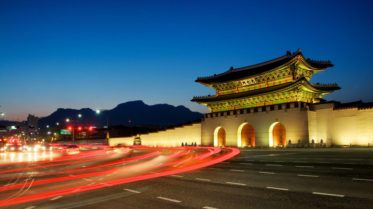
С 1394 года под названием Ханян — столица Кореи, с 1948 года под названием Сеул — столица Республики Корея. Во время Корейской войны город был сильно разрушен. Сохранились остатки крепостной стены с воротами, восстановлен дворцовый комплекс Кёнбоккун XIV века. Имеются объекты Всемирного наследия ЮНЕСКО.
 文化遗产
文化遗产

Suwon ist die größte Stadt und Hauptstadt der Provinz Gyeonggi-do in Südkorea. Sie liegt 48 km südlich von Seoul und ist an deren U-Bahn-Netz mit der Linie 1 angeschlossen. Während der Fußball-Weltmeisterschaft 2002 fanden vier Spiele im am 13. Mai 2001 eröffneten Suwon-World-Cup-Stadion statt.
Samsung Electronics hat seinen Hauptsitz in Suwon.
水原市(朝鮮語:수원시/水原市 Suwon si */?),韩国京畿道首府,地理位置东经127度,北纬37度,大約在首爾以南34公里(21英里),面积121平方公里,人口超118万。
1794年-1796年建成的水原华城是联合国教科文组织世界文化遗产之一。[3]
水原的主要职业球队有韩国职棒联赛KT巫师[4]、韩国职业足球经典联赛水原三星蓝翼[5]、韩国职业足球挑战联赛水原FC[6]。
水原市(スウォンし、韓国語:수원시)は、大韓民国北西部の都市。京畿道の道庁所在地。
ソウル特別市から南35kmに位置する、首都圏南部の中核都市。京畿道庁所在地。中心市街地は、ユネスコの世界遺産に登録されている「華城」の城壁に取り囲まれている城郭都市。名物は水原カルビ(牛カルビの焼肉)。サッカーの水原三星ブルーウィングスも知られる。大韓民国の地方自治法第175条に基づいて特例が適用される特定市に指定されている。
韓国では一般に人口100万人を超える都市は広域市となり道から独立するが、水原市は未だ広域市となっていない。
Suwon[a] (Hangul: 수원; Hanja: 水原, Korean pronunciation: [su.wʌn]) is the capital and largest metropolis of Gyeonggi-do, South Korea's most populous province which surrounds Seoul, the national capital. Suwon lies about 30 kilometres (19 miles) south of Seoul. It is traditionally known as "The City of Filial Piety". With a population close to 1.2 million, it is larger than Ulsan, although it is not governed as a metropolitan city.
Suwon has existed in various forms throughout Korea's history, growing from a small settlement to become a major industrial and cultural center. It is the only remaining completely walled city in South Korea. The city walls are one of the more popular tourist destinations in Gyeonggi Province. Samsung Electronics R&D center and headquarters are in Suwon. The city is served by two motorways, the national railway network, and the Seoul Metropolitan Subway. Suwon is a major educational center, home to 11 universities.[3]
Suwon is home to football club Suwon Samsung Bluewings, which have won the K League on four occasions[4] and AFC Champions League twice. The KT Wiz of the Korea Baseball Organization also plays in Suwon.
Suwon (hangeul : 수원시 prononciation en coréen : /su.wʌn/) est la capitale et la plus grande ville de la province de Gyeonggi en Corée du Sud. Suwon est située environ 30 km au sud de Séoul, sur la ligne ferroviaire nommée Gyeongbu. Certains l'appellent la ville du football coréen, à cause du club Suwon Samsung Bluewings FC, qui est celui qui a le plus de fans en Corée du Sud. Elle est également appelée Samsung City, du fait du nombre important d'employés de Samsung Electronics – environ 40 000 – y vivant et travaillant1. Sa population s'élevait à 1 105 953 habitants au recensement de 2005. La ville est connue pour sa forteresse de Hwaseong, classée au Patrimoine culturel mondial de l’UNESCO en 19972.
Suwon (수원시?, 水原市?, Suwon-siLR) è il capoluogo e la più grande città della provincia di Gyeonggi nella Corea del Sud. Con una popolazione di poco superiore al milione di abitanti è localizzata circa 30 km a sud di Seul. Suwon è famosa per essere l'ultima rimasta delle città fortificate della Corea, e per questo il suo ruolo turistico è molto apprezzato. È inoltre un rinomato centro universitario, con 14 istituti e diversi campus secondari delle università della capitale.
Suwon, oficialmente Ciudad de Suwon (en coreano, 수원시, Suwon-si), es la ciudad capital en la provincia de Gyeonggi al norte de la república de Corea del Sur. Está ubicada al sur de Seúl a unos 30 km y su área es de 121.08 km² y su población total es de 1.098.000. Se conoce tradicionalmente como "La Ciudad de la piedad filial".
Суво́н (кор. 수원시?, 水原市?; Suwon-si) — столица и крупнейший город провинции Кёнгидо Республики Корея. Население ок. 1,2 млн человек. Сувон расположен на 30 километров южнее Сеула. Иногда город называют столицей корейского футбола — в нём располагается самая известная корейская футбольная команда Сувон Самсунг Блюуингз. В городе расположен исследовательский центр ведущих подразделений компании Самсунг Электроникс.
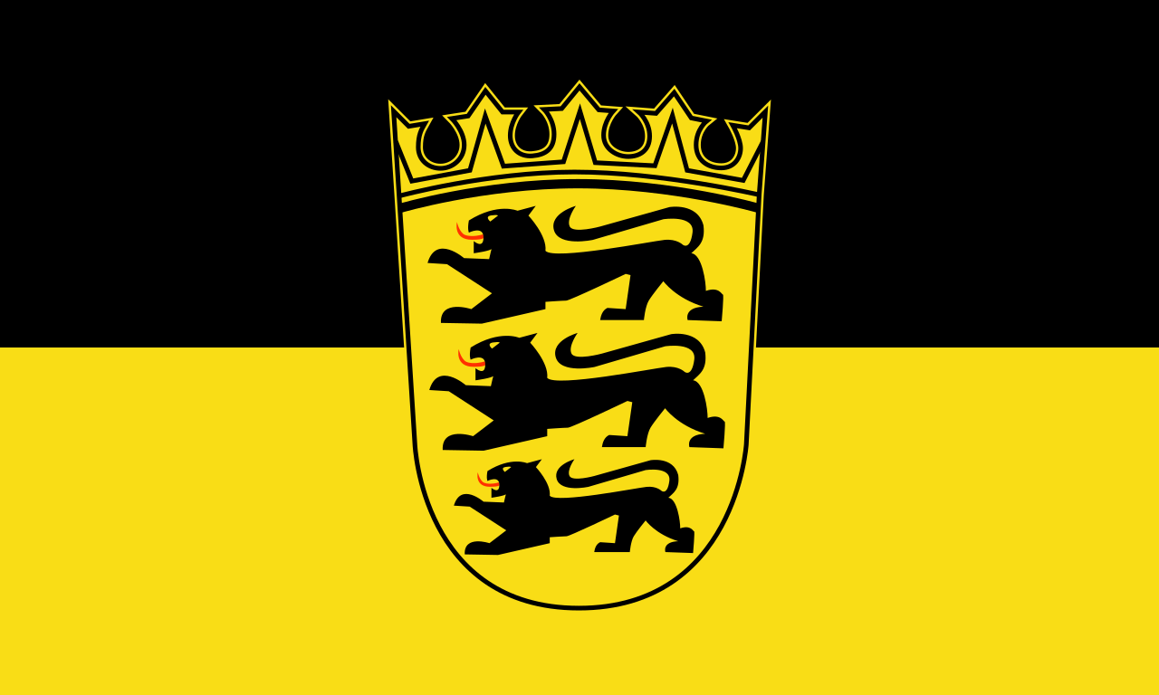 巴登-符藤堡州
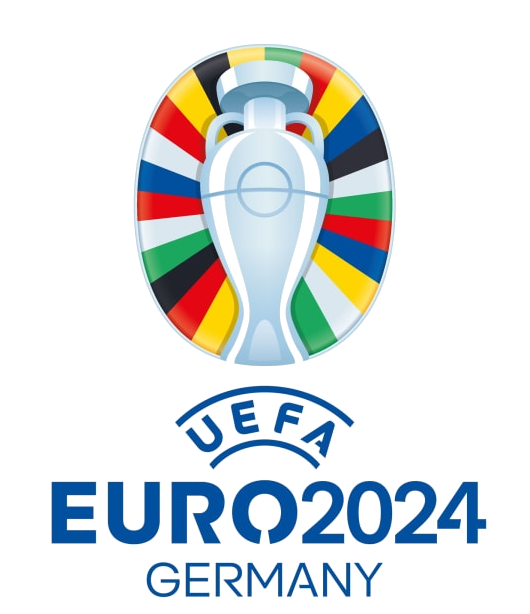 欧洲足球锦标赛 2024
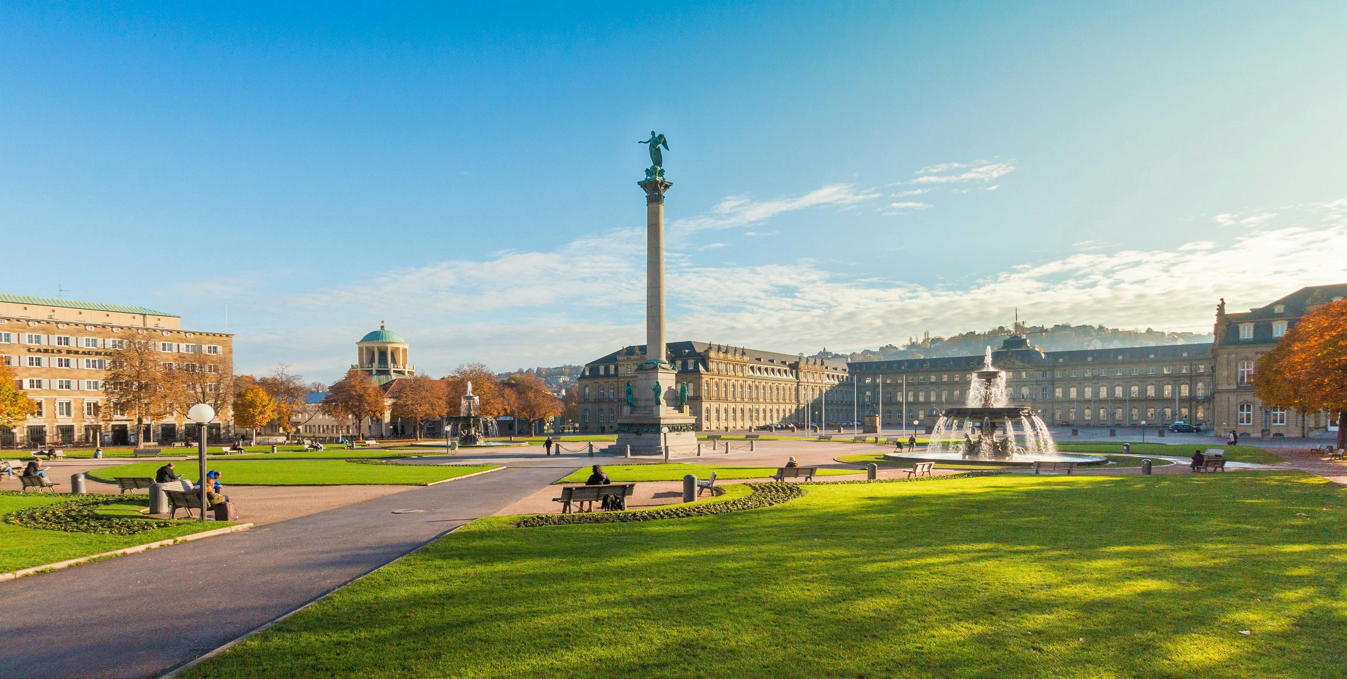

Stuttgart ist die Hauptstadt des deutschen Landes Baden-Württemberg und mit knapp 600.000 Einwohnern dessen größte Stadt. Sie ist die sechstgrößte Stadt Deutschlands und bildet das Zentrum der rund 2,7 Millionen Einwohner zählenden Region Stuttgart. Zudem ist es Kernstadt der siebtgrößten Agglomeration Deutschlands sowie der europäischen Metropolregion Stuttgart (etwa 5,3 Millionen Einwohner), der fünftgrößten in Deutschland. Stuttgart hat den Status eines Stadtkreises und ist in 23 Bezirke gegliedert.
Als Sitz der baden-württembergischen Landesregierung und des Landtags sowie zahlreicher Landesbehörden ist Stuttgart das politische Zentrum des Landes (siehe auch Liste der Behörden und Einrichtungen in Stuttgart). Es ist Sitz des Regierungspräsidiums Stuttgart, das den gleichnamigen Regierungsbezirk verwaltet. In Stuttgart tagt das Regionalparlament der Region Stuttgart, einer der drei Regionen im Regierungsbezirk Stuttgart. Darüber hinaus ist Stuttgart Sitz des evangelischen Landesbischofs von Württemberg (Evangelische Landeskirche in Württemberg) und Teil der katholischen Diözese Rottenburg-Stuttgart. Die Stadt ist ein wichtiger Finanzplatz in Deutschland.
Das Stuttgarter Stadtbild wird durch viele Anhöhen (teilweise Weinberge), Täler (insbesondere der Stuttgarter Talkessel und das Neckartal) und Grünanlagen (unter anderem Rosensteinpark, Schlossgarten) geprägt.
斯图加特是德国西南重镇,巴符州首府。它坐落在内卡河谷地,面积207平方公里,人口58.4万。斯图加特这个地名 源自于德语马场(Stute Garter)二字,古时这里曾是王公贵族的养马场。可是这昔日的马场,今天竟是欧洲经济最发达、人均产值最高的大城市之一,誉满全球的“奔驰”汽车就是 在这里离开生产线。看到城徽上金底黑色骏马,想到斯图加特战后的残破,今日的繁盛,使人不由得赞叹,斯图加特-奔驰的骏马!斯图加特的历史可以追溯到 1000年前。公元950年左右,一位公爵看中这里青山环绕,水草丰美,于是把这里辟为养马场。13世纪这里发展成一座要塞。14世纪符腾堡伯爵迁来府 邸。此后,符腾堡伯国国势日隆,升为公国、王国,都城斯图加特的地位也步步提升,市区逐渐扩大。1871年德意志帝国宣告成立,符腾堡王国作为一邦加入, 斯图加特遂成为帝国西南重镇。从19世纪中叶起,斯图加特开始工业化,各类工厂如雨后春笋破土而出,市区所在的盆地显得过于窄小,于是工厂企业逐渐向坡地 发展,向郊区发展,形成大斯图加特工业区。第二次世界大战中,斯图加特饱经战火,13世纪以来逐渐发展形成的市中心,皆成废墟。现在市中心许多建筑物都是 50年代期间重建的。战后,斯图加特的经济发展更是蒸蒸日上。它已成为德国人均收入最高、失业率最低的城市之一。
斯图加特(德语:Stuttgart,中国大陆、台湾译为斯图加特;香港译为史特加)位于德国西南部的巴登-符腾堡州中部内卡河谷地,靠近黑森林。不仅是该州的州首府,也是州级行政区及斯图加特地区首府和该州的第一大城市。同时也是该州的政治中心:巴符州议会、州政府,和众多的州政府机关部门均设在这里。由于其在经济、文化和行政方面的重要性,是德国最知名的城市之一。
シュトゥットガルト(標準ドイツ語: Stuttgart、アレマン語:Schduagert(シュドゥアガート/シュドゥアゲアト))は、ドイツ連邦共和国の都市。バーデン=ヴュルテンベルク州の州都であり、ドイツ南西部の世界都市。人口は約62万人(2015年)。シュツットガルトとも表記される。
ネッカー川沿いにあり、シュヴァーベン地方北部とフランケン地方南西部であるヴュルテンベルク地方を境目とするドイツを代表する工業都市で、もっとも豊かな地域である。ダイムラー、ポルシェやボッシュなどドイツを代表する世界的な企業の本社がおかれている。一方ではブドウなどの栽培も盛んであり、中央駅のそばには今もブドウ畑が残る。ワインも生産され、農業も盛んな田舎街の側面を併せ持つ。
言語構成は上部ドイツ語の語群であるカトリックであるアレマン語の系統に属するシュヴェービッシュ(シュヴァーベン語)と、プロテスタントである上部フランケン語の系統に属する南フランケン語の一言語であるヴュルテンベルク語などの方言が混合する境界域に位置し、中部・北部ドイツ人たちからは「ドイツの田舎者」と揶揄されることがある。
隣接するエスリンゲン、ルートヴィッヒスブルク、フェルバッハ、ヴァイブリンゲン、などのUバーン(LRT:ライトレールトランジット、ほぼ専用軌道の路面電車)、Sバーン(都市近郊電車)が直通運転される近隣周辺都市を合わせて人口100万人を越えるシュトゥットガルト都市圏を形成する。中央駅正面から歩行者専用道路のケーニッヒストラーセが伸び、通りを進んでいくと左手に新宮殿、広場、旧宮殿、ラートハウス(市役所)、マルクトプラッツ(市場)、ブロイニンガーデパートなどが現われ、市の中心部となる。
欧州議会があるフランス・ストラスブールへ車で1時間半、ミュンヘンへ2時間、フランクフルトへ1時間半、スイス・チューリッヒへ2時間半とヨーロッパのへそともいえる絶好のロケーションに位置する。近隣の都市としては、約40キロ北にハイルブロン、35キロ西にシュヴァルツヴァルトの中心都市プフォルツハイム、60キロ北西にシュヴァルツヴァルトを越えライン川沿いにドイツ連邦最高裁判所、連邦憲法裁判所の所在地であるカールスルーエ、35キロ南にロイトリンゲンが位置している。
Stuttgart (/ˈʃtʊtɡɑːrt/ SHTUUT-gart;[4] German: [ˈʃtʊtɡaɐ̯t] (![]() listen); Swabian: Schduagert, pronounced [ˈʒ̊d̥ua̯ɡ̊ɛʕd̥]; names in other languages) is the capital and largest city of the German state of Baden-Württemberg. Stuttgart is located on the Neckar river in a fertile valley known locally as the "Stuttgart Cauldron." It lies an hour from the Swabian Jura and the Black Forest. Its urban area has a population of 609,219,[5] making it the sixth largest city in Germany.[6] 2.7 million people live in the city's administrative region[7] and another 5.3 million people in its metropolitan area,[8] making it the fourth largest metropolitan area in Germany. The city and metropolitan area are consistently ranked among the top 20 European metropolitan areas by GDP; Mercer listed Stuttgart as 21st on its 2015 list of cities by quality of living,[a][9] innovation agency 2thinknow ranked the city 24th globally out of 442 cities [10][b] and the Globalization and World Cities Research Network ranked the city as a Beta-status world city in their 2014 survey.[11]
listen); Swabian: Schduagert, pronounced [ˈʒ̊d̥ua̯ɡ̊ɛʕd̥]; names in other languages) is the capital and largest city of the German state of Baden-Württemberg. Stuttgart is located on the Neckar river in a fertile valley known locally as the "Stuttgart Cauldron." It lies an hour from the Swabian Jura and the Black Forest. Its urban area has a population of 609,219,[5] making it the sixth largest city in Germany.[6] 2.7 million people live in the city's administrative region[7] and another 5.3 million people in its metropolitan area,[8] making it the fourth largest metropolitan area in Germany. The city and metropolitan area are consistently ranked among the top 20 European metropolitan areas by GDP; Mercer listed Stuttgart as 21st on its 2015 list of cities by quality of living,[a][9] innovation agency 2thinknow ranked the city 24th globally out of 442 cities [10][b] and the Globalization and World Cities Research Network ranked the city as a Beta-status world city in their 2014 survey.[11]
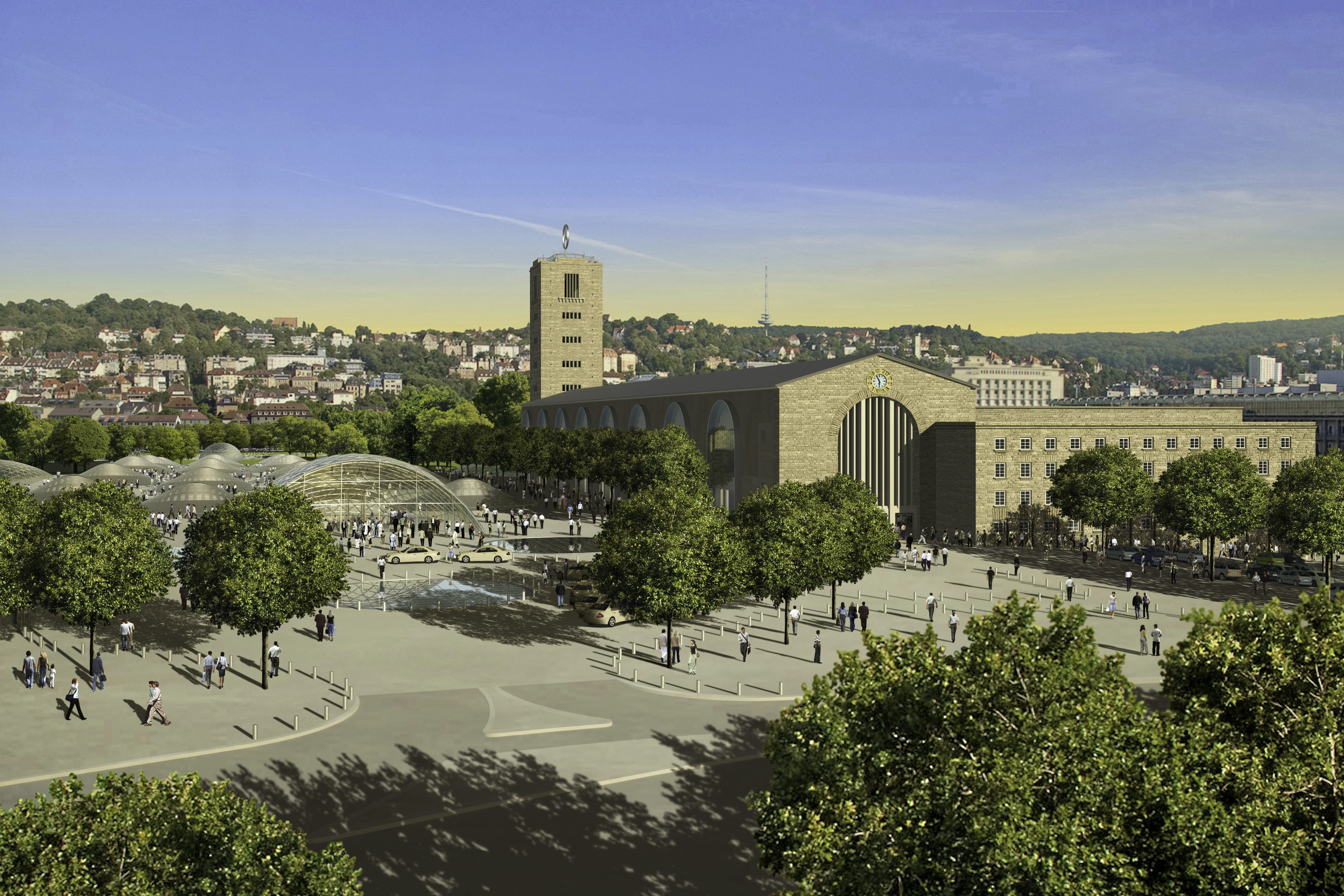
Since the 6th millennium BC, the Stuttgart area has been an important agricultural area and has been host to a number of cultures seeking to utilize the rich soil of the Neckar valley. The Roman Empire conquered the area in 83 AD and built a massive castrum near Bad Cannstatt, making it the most important regional center for several centuries. Stuttgart's roots were truly laid in the 10th century with its founding by Liudolf, Duke of Swabia, as a stud farm for his warhorses. Initially overshadowed by nearby Cannstatt, the town grew steadily and was granted a charter in 1320. The fortunes of Stuttgart turned with those of the House of Württemberg, and they made it the capital of their county, duchy, and kingdom from the 15th century to 1918. Stuttgart prospered despite setbacks in the Thirty Years' War and devastating air raids by the Allies on the city and its automobile production during World War II. However, by 1952, the city had bounced back and it became the major economic, industrial, tourism and publishing center it is today.[12]
Stuttgart is also a transport junction, and possesses the sixth-largest airport in Germany. Several major companies are headquartered in Stuttgart, including Porsche,[13] Bosch,[14] Mercedes-Benz,[15] Daimler AG,[16] and Dinkelacker.[17]
Stuttgart is unusual in the scheme of German cities.[18] It is spread across a variety of hills (some of them covered in vineyards),[19] valleys (especially around the Neckar river and the Stuttgart basin) and parks. This often surprises visitors who associate the city with its reputation as the "cradle of the automobile".[20][21] The city's tourism slogan is "Stuttgart offers more".[22] Under current plans to improve transport links to the international infrastructure (as part of the Stuttgart 21 project), the city unveiled a new logo and slogan in March 2008 describing itself as "Das neue Herz Europas" ("The new Heart of Europe").[23] For business, it describes itself as "Where business meets the future". In July 2010, Stuttgart unveiled a new city logo, designed to entice more business people to stay in the city and enjoy breaks in the area.[24]
Stuttgart is a city with a high number of immigrants. According to Dorling Kindersley's Eyewitness Travel Guide to Germany, "In the city of Stuttgart, every third inhabitant is a foreigner."[25] 40% of Stuttgart's residents, and 64% of the population below the age of five, are of immigrant background.[26]
Stuttgart (prononcé en allemand : [ˈʃtʊtɡaʁt] Écouter, anciennement Stutgard ou Stougard en français2) est la capitale du Land de Bade-Wurtemberg, au sud de l'Allemagne. Sixième plus grande ville d'Allemagne, Stuttgart a une population de 613 392 habitants (recensement de décembre 20111) tandis que la région métropolitaine de Stuttgart en compte 5,3 millions (2008)3.
La ville se trouve au centre d'une région très peuplée et est entourée d'une couronne de petites villes. Cette zone urbaine intérieure appelée « région de Stuttgart » a une population de 2,7 millions d'habitants4, faisant du « Grand Stuttgart » la quatrième plus grande ville-région en Allemagne après la Ruhr, Francfort-sur-le-Main et Berlin.
Stuttgart se trouve sur une série de collines, de vallées et de parcs — fait inhabituel pour les villes allemandes5 et souvent cause de surprise pour les visiteurs qui associent principalement la ville avec sa réputation industrielle de « berceau de l'automobile ».
Stuttgart a le statut de Stadtkreis, ce qui fait d'elle une aire urbaine auto-administrée. La ville est également le siège du parlement régional et du conseil local.
La devise de la ville est « Stuttgart est plus » — pour les touristes et les affaires, Stuttgart se décrit elle-même comme « Standort Zukunft », traduit par la mairie en « Lorsque les affaires rencontrent le futur ». En 2007, le bourgmestre a présenté Stuttgart aux investisseurs étrangers comme « la puissance créatrice de l'Allemagne ». Avec les plans actuels visant à améliorer les liaisons de transport aux infrastructures internationales (dans le cadre du projet Stuttgart 21), la ville a dévoilé un nouveau logo et un slogan en mars 2008, se décrivant comme Das neue Herz Europas (« Le nouveau cœur de l'Europe »)6.
Stuttgart est parfois surnommée la Schwabenmetropole7 (métropole souabe8), une référence au dialecte souabe parlé par les autochtones.
Stoccarda (in tedesco Stuttgart , in dialetto svevo Schdùagert) è una città extracircondariale di circa 600.000 abitanti della Germania meridionale, capitale dello stato federato del Baden-Württemberg e del distretto amministrativo omonimo.
La città si trova in prossimità della Foresta Nera e del fiume Neckar. Ha una superficie di 207 km².
Stuttgart (![]() [ˈʃtʊtɡaʁt] (?·i); antiguamente y en desuso Estucardia en español) es la capital del estado federado alemán Baden-Wurtemberg. Con 600 038 habitantes,2 Stuttgart es la ciudad más grande de Baden-Wurtemberg y la sexta de Alemania. En Stuttgart encontramos el parlamento de su Bundesland y su gobierno correspondiente, así como otras autoridades políticas y de la administración federal. Las grandes ciudades alemanas más importantes y cercanas a Stuttgart son: Fráncfort (240 km al noroeste), Múnich (aproximadamente 220 km al sureste de Stuttgart) y Karlsruhe (a 80 km al noroeste).
[ˈʃtʊtɡaʁt] (?·i); antiguamente y en desuso Estucardia en español) es la capital del estado federado alemán Baden-Wurtemberg. Con 600 038 habitantes,2 Stuttgart es la ciudad más grande de Baden-Wurtemberg y la sexta de Alemania. En Stuttgart encontramos el parlamento de su Bundesland y su gobierno correspondiente, así como otras autoridades políticas y de la administración federal. Las grandes ciudades alemanas más importantes y cercanas a Stuttgart son: Fráncfort (240 km al noroeste), Múnich (aproximadamente 220 km al sureste de Stuttgart) y Karlsruhe (a 80 km al noroeste).
Stuttgart tiene el estatus de ciudad-distrito, unificada por un presidente. También es sede del obispo evangélico de Wurtemberg y de un obispado católico (Bistum Rottenburg-Stuttgart). La ciudad posee dos universidades, escuelas técnicas y es sede de varios institutos de investigación, como el Centro Aeroespacial Alemán (DLR), el Fraunhofer o el Max Planck.
Stuttgart es la puerta de entrada a la Selva Negra y al Jura de Suabia. Rodeada de colinas, bosques y viñedos que llegan hasta el centro. El puerto se sitúa al noreste de la ciudad, a orillas del río Neckar.
Шту́тгарт (нем. Stuttgart [ˈʃtʊtɡaʁt], от нем. Stutengarten — «конюшенный сад», алем. Schduagert) — город в Германии, административный центр земли Баден-Вюртемберг, один из важнейших промышленных центров Германии, а также важный культурный центр. В Штутгарте проживает около 630 тысяч человек (декабрь 2016 года), город занимает по этому показателю шестое место в стране.
Штутгарт был основан в 950 году швабским герцогом Людольфом и до 1496 года оставался главным городом графства Вюртемберг, с 1803 года — курфюршества, с 1806 года — королевства Вюртемберг, а после 1918 года — республики Вюртемберг. После строительства в городе автозаводов будущего концерна Mercedes-Benz город стал известен как «колыбель автомобилестроения».
新潟市(日语:新潟市/にいがたし Niigata shi */?)是位于日本新潟县东北部(下越地方)的市,为新潟县首府,地处日本最长河流信浓川的入海口,是本州日本海侧地区与北陆信越地方的第一大城、以及唯一的政令指定都市[1]。身为港埠都市,新潟的开发历史悠久,至江户时代已是日本海沿岸重要港口之一,为幕末美日修好通商条约开港五港之一[2],现在也是水陆交通的要冲。
Niigata (jap. 新潟市 Niigata-shi, deutsch ‚[kreisfreie] Stadt Niigata‘, englisch Niigata City/City of Niigata/Niigata, Niigata) ist eine designierte Großstadt und der Verwaltungssitz der gleichnamigen japanischen Präfektur Niigata (historisch Provinz Echigo) auf der Hauptinsel Honshū. Niigata liegt an der Mündung des Flusses Shinano und ist eine der größten Hafenstädte an der Küste zum Japanischen Meer.
Niigata hat 790.646 Einwohner und liegt 300 km nördlich von Tokio.
Die Region ist ein Erdöl- und Erdgas-Fördergebiet, daher gibt es hier auch Erdölraffinerien. Daneben spielen die Papier- und Nahrungsmittelindustrie sowie der Maschinen- und Schiffbau eine bedeutende wirtschaftliche Rolle.
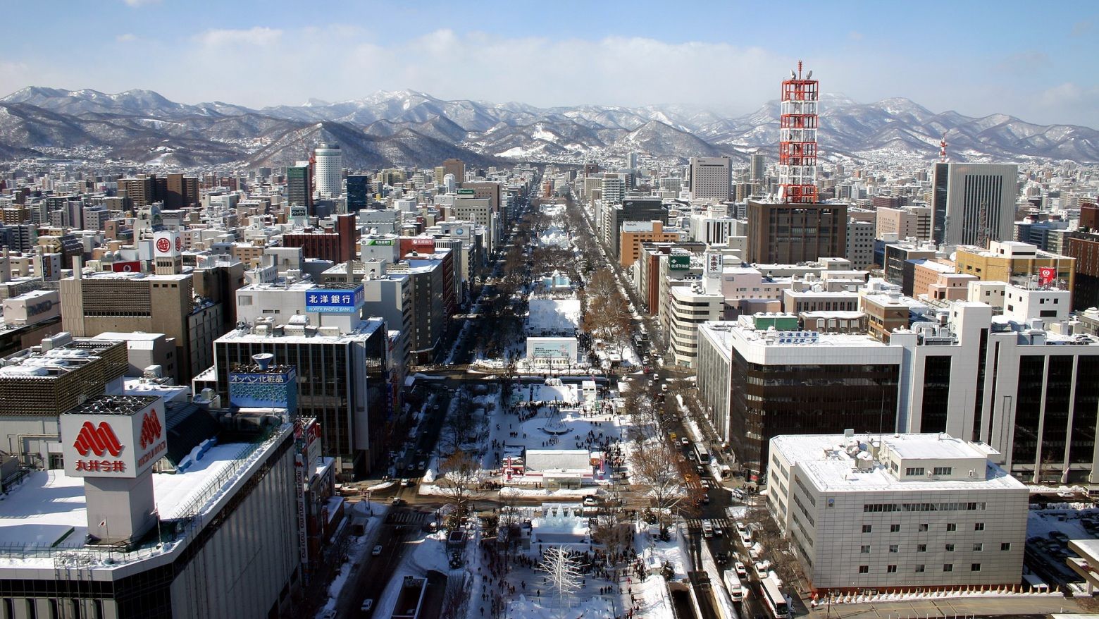
 滑雪旅游
滑雪旅游
Sapporo (jap. 札幌市, -shi, aus Ainu sat poro (pet), dt. „trockener, großer (Fluss)“[1]) ist mit 1,9 Millionen Einwohnern die größte Stadt von Hokkaidō, der nördlichsten der vier japanischen Hauptinseln.
Sapporo ist der Verwaltungssitz der Präfektur Hokkaidō sowie der Unterpräfektur Ishikari.
Sapporo wurde 1869 als Sitz der Kolonialverwaltung Hokkaidōs gegründet, das seit dem 19. Jahrhundert zu Japan gehört. Erst in den 1950er Jahren löste es das nahegelegene und deutlich ältere Otaru als bevölkerungsreichste Stadt Hokkaidōs ab. Die Stadt wurde, ähnlich wie Kyōto oder viele amerikanische Städte, in einem Schachbrettmuster geplant.
Sapporos landwirtschaftliche Universität, die ebenfalls 1869 gegründet wurde und anfangs in Tokio beheimatet war, ist vor allem durch ihren ersten Präsidenten, William Smith Clark, bekannt geworden. Er wurde von der japanischen Regierung als Berater in Erziehungsfragen eingeladen. Vor allem die Abschiedsworte an seine Studenten, von denen er viele zum Christentum bekehrt hatte, haben einen bleibenden Eindruck hinterlassen: Boys, be ambitious! (dt. „Jungs, seid ehrgeizig!“).
In Sapporo fanden die Olympischen Winterspiele 1972 statt, die ersten Olympischen Winterspiele in Asien. Seitdem verbindet eine Städtepartnerschaft Sapporo mit München, dem Austragungsort der Olympischen Sommerspiele desselben Jahres.
札幌市(日语:札幌市/さっぽろし Sapporo shi */?)是位于日本北海道道央地区的都市,为北海道首府、以及石狩振兴局本部所在地,也是政令指定都市之一[1]。其拥有超过190万人口,是北海道最大都市、以及日本人口第五大都市,集中了北海道35%的人口,而札幌都市圈更集中了北海道约半数的人口。虽然地理位置位于北海道西部,但却是北海道铁路、高速公路、航空路线的放射点,因此在交通上也是北海道的中心。
札幌市的历史开始于1869年日本设立开拓使时在此设置札幌本府[1]。札幌的建设计划由时任开拓判官岛义勇提出,他参考京都规划了棋盘状城市,以创成桥东侧为基点,将创成川作为南北轴,渡岛通(现南1条通)作为东西轴[2][3]。而大通公园则是现在札幌市的东西主干线[4]。1972年,札幌市举办了亚洲首届冬季奥运会[5]。此后札幌市举办了多种国际体育赛事。札幌市还是日本著名的观光都市,并且在日本的魅力城市排行榜中亦排名前列[6]。2013年,札幌市加入了联合国教科文组织全球创意城市网络中的媒体艺术城市,是世界第二个和亚洲首个加盟城市[7][8]。
札幌市的市徽外观是一个六角形,代表冰晶(雪花)的形状,是北海道的象征。在六角型内侧的圆形其实是汉字“札”字的变体,而整个圆形又可视为是日文片假名“ロ”字的变形,是札幌的日语片假名写法“サッポロ”中的一部分。市徽中央的五芒星代表北斗星,是北方的象征。并且五芒星的形状又与日文片假名字母“ホ”近似,是日语中“北方”或“北海道”的拼音字首[1]。
札幌市(さっぽろし)は、北海道の政令指定都市。道庁所在地および石狩振興局所在地。
日本最北の政令指定都市であり、全国の市の中では横浜市、大阪市、名古屋市に次ぐ4番目の人口を有しており、北海道全体の人口の約3割強(約36%)を占めている。北海道のプライメイトシティであり、札幌都市圏を形成している。アイヌの人々が暮らしていた蝦夷地は1869年(明治2年)に北海道と改称され開拓使が置かれて札幌本府の建設が始まった[1]。1875年(明治8年)に最初の屯田兵が入植。札幌の建設計画は当時の開拓判官島義勇によって構想され、京都を参考にした街づくりは創成橋東側のたもとを基点に東西の基軸を創成川、南北の基軸を渡島通(現在の南1条通)として区画割を進めていった[2][3][4](現在の南北の基軸は大通公園となっている[5])。その後、周辺町村を編入・合併して市域を拡大していった。
1972年(昭和47年)にはアジア初となる冬季オリンピック(札幌オリンピック)を開催[6]。その後も国際スキー連盟の各種国際大会やアジア冬季競技大会、国際大学スポーツ連盟主催の冬季ユニバーシアード競技大会、FIFAワールドカップ、FIBAバスケットボール・ワールドカップ、世界ラリー選手権など数多くの国際大会が開催されている。札幌市としても各種イベントや展示会、企業の会議や報奨旅行などの誘致・開催 (MICE) への積極的な取り組みを行っており[7]、「国際会議観光都市」に認定されている。毎年1,300万人前後の観光客が訪れる観光都市となっており[8]、市町村の魅力度ランキング調査でも毎年上位にランクインしている都市である[9]。2013年(平成25年)にはユネスコ(国際連合教育科学文化機関)により創設された創造都市ネットワークの「メディアアーツ都市」分野に世界で2都市目に(アジアでは初めて)認定された[10][11]。2026年冬季オリンピック開催地に立候補することを表明して誘致活動を行っていたが[12][13]、立候補および誘致活動を2030年大会に変更する意向を示した。
Sapporo (札幌市 Sapporo-shi) is the fifth largest city of Japan by population, and the largest city on the northern Japanese island of Hokkaido. It is the capital city of Hokkaido Prefecture and Ishikari Subprefecture. It is an ordinance-designated city.
Sapporo hosted the 1972 Winter Olympics (the first ever held in Asia). Its annual Sapporo Snow Festival draws more than 2 million tourists from abroad.[2]
Sapporo (札幌市, Sapporo-shi) est la cinquième ville japonaise en nombre d'habitants et la troisième en superficie. Située dans l'île de Hokkaidō, dont elle est la capitale régionale, elle est traversée par la rivière Toyohira.
Sapporo (札幌市 Sapporo-shi?, ) è una città giapponese di circa 1 910 000 abitanti, capoluogo della prefettura di Hokkaidō e quinta città per grandezza del Giappone. Fa parte della sottoprefettura di Ishikari, situata nella zona sud-occidentale dell'isola di Hokkaidō.
Sapporo è nota fuori dal Giappone per aver ospitato le Olimpiadi Invernali del 1972, le prime tenutesi in Asia, e per il famoso Festival della neve che attira oltre 2 milioni di turisti da tutto il mondo. La città è anche conosciuta per le birrerie Sapporo, che prendono il nome dalla città stessa, e dai biscotti Shiroi Koibito, il classico souvenir acquistato da chi visita la città.
Sapporo (en japonés: 札幌市; Sapporo-shi) (![]() escuchar) es una ciudad de Japón, situada en la parte suroeste interior de la isla de Hokkaidō. Es la capital de la prefectura homónima y su población supera los 1,9 millones de habitantes, lo que la convierte en la quinta localidad más grande del país. El área total del territorio es de 1121 km².
escuchar) es una ciudad de Japón, situada en la parte suroeste interior de la isla de Hokkaidō. Es la capital de la prefectura homónima y su población supera los 1,9 millones de habitantes, lo que la convierte en la quinta localidad más grande del país. El área total del territorio es de 1121 km².
Fue fundada en 1869 como capital de la nueva prefectura de Hokkaidō tras la colonización de la isla durante la era Meiji, en sustitución de Hakodate. Al levantarla de cero, las autoridades niponas recurrieron a consejeros occidentales —en su mayoría, estadounidenses— que tuvieron gran influencia sobre la planificación urbana, el establecimiento de industrias, el estilo arquitectónico y los centros educativos. Se encuentra rodeada por cadenas montañosas y, pese a su crecimiento demográfico, ha mantenido numerosas zonas verdes tanto en el núcleo urbano como en las afueras; cuenta con un total de 2.700 parques,3 algunos tan importantes como el Jardín Botánico y el parque nacional Shikotsu-Tōya.
Presenta temperaturas más bajas que el resto de ciudades japonesas debido a su clima continental húmedo, con continuas nevadas en los meses de invierno y tiempo suave durante el verano. Por esta razón, es un destino turístico especializado en deportes invernales. Durante el siglo XX han surgido eventos que le han dotado de fama internacional, siendo el más importante de ellos el Festival de la nieve de Sapporo que se celebra cada mes de febrero. Dispone de una red desarrollada de transporte por carretera y ferrocarril, con un aeropuerto propio para vuelos regionales (Okadama) y otro internacional en las cercanías (Nuevo Aeropuerto de Chitose), que es el tercero mayor de Japón en número de pasajeros.
Cuenta además con una amplia oferta cultural y educativa. La Universidad de Hokkaidō, fundada por William S. Clark en 1876 como Escuela de Agricultura y reconvertida en 1918 en la actual institución, es una de las siete universidades nacionales de Japón. Tiene un total de 11.600 alumnos de grado y 6.300 de posgrado.4
Sapporo ha organizado los XI Juegos Olímpicos de Invierno de 1972. Además fue una de las sedes de la Copa Mundial de Fútbol de 2002.
Са́ппоро (яп. 札幌市 Саппоро-си, слушать ) — пятый по величине город Японии, важнейший экономический, промышленный, образовательный и культурный центр Хоккайдо, город государственного значения Японии, административный центр губернаторства Хоккайдо. Площадь города составляет 1121,12 км²[2], население — 1 933 787 человек (30 июня 2014)[3], плотность населения — 1724,87 чел./км². В городе расположен университет Хоккайдо.
Саппоро — столица Зимних Олимпийских игр 1972 года и трёх Зимних Азиатских игр 1986, 1990 и 2017 годов. Саппоро — курортное место, в его окрестностях имеется множество горячих источников. Здесь ежегодно проводится Снежный фестиваль, который привлекает более 2 миллионов туристов со всего мира.