
Deutsch-Chinesische Enzyklopädie, 德汉百科
 China
China
 Energy resource
 Geography
 Mongolei
 Architecture

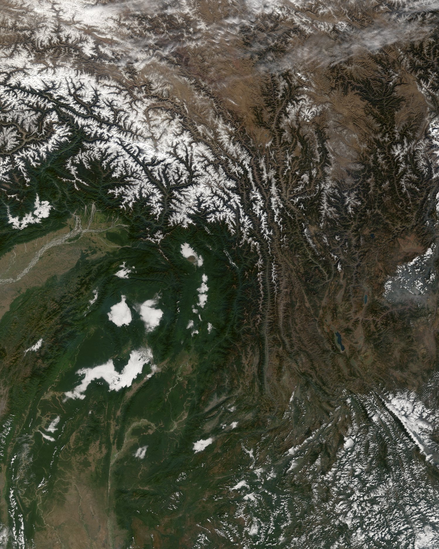
横断山脉(英文:Hengduan Mountain Range)是中国西南部的著名山脉,有广义和狭义的区分。广义的横断山脉位于青藏高原东南部(介于北纬22°~32°05′,东经97°~103°之间),为四川省西部、云南省西北部和西藏自治区东部南北向山脉的总称,是青藏高原的边缘山系。它东起邛崃山,西抵伯舒拉岭-高黎贡山,北达昌都、甘孜至马尔康一线,南抵中缅边境的山区,面积60余万平方公里,是中国最长、最宽和最典型的南北向山系。狭义的横断山脉指三江并流地区的四条山脉,即沙鲁里山、芒康山-云岭、他念他翁山-怒山及伯舒拉岭-高黎贡山。
Hengduan Shan (chinesisch 橫斷山 / 横断山, Pinyin Héngduàn Shān), das auch Hengduan-Gebirge (橫斷山脈 / 横断山脉, Héngduàn Shānmài) genannt wird, erstreckt sich über eine Fläche von 800.000 km²[1] im Südosten des Tibetischen Hochlands in China (Asien). Sein Hauptgipfel Gongga Shan misst 7556 m.[2]
Als östliche Fortsetzung des Gebirgsknotens von Himalaya, Nyainqêntanglha mit der Teilkette des Taniantawang Shan erstreckt sich dieses Gebirge zwischen der Nord- und Ostgrenze von Myanmar und über den äußersten Südosten des Autonomen Gebiets Tibet sowie die beiden chinesischen Provinzen Yunnan und Sichuan zwischen 22° und 32°05′ N und 97° und 103° E.
Die bekanntesten Bergketten des Gebirges sind Gaoligong Shan, Nu Shan und Yun Ling, die die Oberläufe der Flüsse Irrawaddy, Saluen, Mekong und Jangtsekiang voneinander trennen.
横断山脈(おうだんさんみゃく)は中華人民共和国南西部の山脈。チベット高原(青蔵高原)の南東に位置し、四川省西部、雲南省西部、チベット自治区東部の交わるあたりを南北方向に走っている山脈の総称である。
東には邛崍(キョウライ)山脈が、西には伯舒拉嶺(ボシュラ山脈)が走り、北はチャムド(昌都)・カンゼ(甘孜)・バルカム(馬爾康)を結ぶ線に達し、南は中国とミャンマーの国境地帯にあたる。面積は60万平方キロメートル以上。中国にある南北方向の山脈のうち、最も長く、最も幅広い山脈である。
The Hengduan Mountains (simplified Chinese: 横断山脉; traditional Chinese: 橫斷山脈; pinyin: Héngduàn Shānmài) are a group of mountain ranges in southwest China that connect the southeast portions of the Tibetan Plateau with the Yunnan–Guizhou Plateau. The Hengduan Mountains are primarily large north-south mountain ranges that effectively separate lowlands in northern Myanmar from the lowlands of the Sichuan Basin. These ranges are characterized by significant vertical relief originating from the Indian subcontinent's collision with the Eurasian Plate, and further carved out by the major rivers draining the eastern Tibetan Plateau. These rivers, the Yangtze, Mekong, and Salween, are recognized today as the Three Parallel Rivers UNESCO World Heritage Site.
The Hengduan Mountains cover much of western present-day Sichuan province as well as the northwestern portions of Yunnan, the easternmost section of the Tibet Autonomous Region, and touching upon parts of southern Qinghai. Additionally, some parts of eastern Kachin State in neighbouring Myanmar are considered part of the Hengduan group. The Hengduan Mountains are approximately 900 kilometres (560 mi) long, stretching from 33°N to 25°N. Depending on extent of the definition, the Hengduan Mountains are also approximately 400 kilometres (250 mi) wide under the narrowest definition, ranging from 98°E to 102°E. The area covered by these ranges roughly corresponds with the historical region known as Kham.
The Hengduan Mountains subalpine conifer forests is a palaearctic ecoregion in the Temperate coniferous forests biome that covers portions of the mountains.
Les monts Hengduan (chinois simplifié : 横断山脉) sont un massif montagneux situé dans la partie orientale du Xinan, au Sud-Ouest de la Chine. Ils culminent à 7 556 m d'altitude au Minya Konka. Ils forment la partie sud-est du plateau tibétain au contact du bassin du Sichuan et s'étendent jusqu'à la frontière de la Birmanie. Ils couvrent approximativement la province historique du Kham.
Ces montagnes de la Chine occidentale possèdent une forêts de conifères répertoriée comme Écorégion terrestre du WWF. Elles sont considérées par le Conservation International comme un point chaud de biodiversité1. Elles abritent des espèces rares comme le panda géant dans la réserve naturelle nationale de Wolong.
I monti Hengduan (cinese semplificato: 横断山脉; cinese tradizionale: 橫斷山脈; pinyin: Héngduàn Shānmài) sono un sistema montuoso dell'Asia orientale (latitudine: 22-32° N, longitudine: 97-103° E) che forma la parte sud-orientale dell'altopiano tibetano e il confine occidentale del bacino del Sichuan. Sono situati principalmente in Cina, anche se la loro estremità meridionale costituisce la frontiera con il Myanmar (Stato Kachin). Questa vasta regione montuosa occupa la maggior parte occidentale della provincia del Sichuan, nonché l'angolo nord-occidentale dello Yunnan e la sezione orientale della Regione Autonoma del Tibet.
I monti sono situati nella regione del Kham, una delle province culturali del Tibet storico.
Las montañas Hengduan (en chino: 横断 山脉, pinyin: Hengduan Shānmài) son un sistema montañoso del Asia Oriental (latitud: 22° ~ 32°N, longitud: 97° ~ 103° E) que forma la parte sur-oriental de la meseta Tibetana y el límite oeste de la cuenca de Sichuan. Está principalmente en la República Popular de China, aunque las estribaciones meridionales forman la frontera con Birmania, con el estado Kachin. La extensa región montañosa ocupa la mayor parte occidental de la provincia de Sichuan, así como la esquina noroeste de la provincia de Yunnan y la sección oriental de la Región Autónoma del Tíbet.
Las montañas están en la región de Kham, una de las provincias culturales del Tíbet histórico. De aquí es originario el panda rojo, en peligro de extinción.1
Сино-Тибетские горы, также называются Сычуаньские Альпы и Хэндуаньшань (кит. упр. 横断山脉, пиньинь: Héngduàn Shānmài, буквально: «поперечно разломанные горы») — условно выделяемый горный регион в Китае, расположенный к востоку от Тибетского нагорья. Длина около 750 км (от верховий Хуанхэ на севере до среднего течения Янцзы), ширина до 400 км. От запада к востоку высота уменьшается от 5000—6500 м до 1000—1200 м. Самая высокая точка — гора Гонгга (7590 м). По юго-западной части гор проходит граница между Китаем и Мьянмой.
Территория, занимаемая Сино-Тибетскими горами, примерно совпадает с историко-культурным регионом, известным как Кам.
Сино-Тибетские горы не являются чётко обособленной орографической областью, а скорее представляют собой сильно расчленённую окраину Тибетского нагорья на границе с равнинами и низкогорьями Восточного Китая. Состоят из нескольких хребтов, которые разделены глубокими долинами рек Салуин, Меконг, Янцзы и их притоков (глубина ущелий достигает 3000 м). В составе гор выделяют хребты Чола, Шалулишань, Дасюэшань и Цюнлайшань.
Горы очень сейсмичны, по их восточному краю проходит разлом Лунмэньшань, в котором находился эпицентр Сычуаньского землетрясения 2008 года.
В районе Сино-Тибетских гор субтропический климат западной окраины Сычуаньской котловины резко переходит в континентальный климат Тибетского нагорья. В южной части выпадает до 1200 мм осадков, на наветренных склонах гор — более 2000 мм, к западу количество осадков снижается до 600 мм в год.
Регион Сино-Тибетских гор является ареалом находящихся под угрозой вымирания Больших панд.
Anhui Sheng-AH
Beijing Shi-BJ
Chongqing Shi-CQ
Manufacturing and Innovation
 Financial
Financial
Financial
 *China economic data
Fujian Sheng-FJ
Guangdong Sheng-GD
Guangxi Zhuangzu Zizhiqu-GX
Hubei Sheng-HB
Hunan Sheng-HN
Jiangsu Sheng-JS
Jilin Sheng-JL
Liaoning Sheng-LN
Shaanxi Sheng-SN
Shandong Sheng-SD
Shanghai Shi-SH
Sichuan Sheng-SC
*China economic data
Fujian Sheng-FJ
Guangdong Sheng-GD
Guangxi Zhuangzu Zizhiqu-GX
Hubei Sheng-HB
Hunan Sheng-HN
Jiangsu Sheng-JS
Jilin Sheng-JL
Liaoning Sheng-LN
Shaanxi Sheng-SN
Shandong Sheng-SD
Shanghai Shi-SH
Sichuan Sheng-SC
 Companies
 Economy and trade
Zhejiang Sheng-ZJ
Economy and trade
Zhejiang Sheng-ZJ


 Life and Style


恭王府由府邸和花园两部分组成,南北长约330米,东西宽180余米,占地面积约61120平方米,其中府邸占地32260平方米,花园占地28860平方米。
恭王府王府在南,花园在北,由高高的后罩楼将王府与花园分开。
恭王府分中东西三路,分别由多过四合院组成,后为长160米的二层后罩楼。
恭王府花园也分为三路。中路是西洋门,独乐峰,蝠池,安善堂及左右配殿明道堂,棣华轩,福字碑,邀月台,蝠厅;东路是怡神所垂花门,大戏楼,芭蕉院;西路是湖心亭,澄怀撷秀。此外还有龙王庙、榆关、妙香亭、流杯亭、艺蔬圃。
Prince Gong's Mansion,[1] also known as the Prince Kung Mansion, is a museum and tourist attraction located in Xicheng District, Beijing, just north of the Shichahai Lake. It consists of large siheyuan-style mansions and gardens. Originally constructed for Heshen, an official highly favoured by the Qianlong Emperor, it was later renamed after Prince Gong, a Manchu prince and influential statesman of the late Qing dynasty, who inhabited the mansion in the late 19th century.

 Science and technology

 IT-Times

南京高新技术产业开发区(简称南京高新区)是1991年经国务院批准的江苏首家国家级高新区,位于南京市江北新区浦口区,现管辖面积扩展至386平方公里 。该区实行“一区多园”管理模式,构建以江北新区为核心、新港和江宁国家高新园为两翼的协同发展格局。主导产业包括软件及电子信息、生物医药、卫星导航应用、航空航天与新材料,建有南京软件园、生物医药谷、北斗卫星导航产业基地等专业园区。区内有名爵汽车、中车浦镇、国电南瑞、国电南自、焦点科技、爱信诺、微软、萨蒂扬、中华网、台塑网、百敖、盛大网络、鸿鹰动漫、鸿宝影视、药石科技、同仁堂、药明康德、欧加农制药、康海药业、微创科技、苏美达、瑞尔药业和川博生物等企业投资设立的厂区。
Der Hightech-Industriepark Nanjing (kurz: Nanjing High-Tech-Zone) ist der erste staatliche Hightech-Industriepark in der Provinz Jiangsu, der 1991 vom Staatsrat genehmigt wurde. Er befindet sich im Bezirk Pukou des Stadtteils Jiangbei in Nanjing und erstreckt sich mittlerweile über eine Fläche von 386 Quadratkilometern. Der Park verfolgt ein Verwaltungsmodell mit dem Ansatz „ein Park, mehrere Zonen“ und hat ein Modell der koordinierten Entwicklung geschaffen, bei dem der Stadtteil Jiangbei den Kern bildet und die nationalen Hightech-Parks Xingang und Jiangning die beiden Flügel bilden. Zu den führenden Branchen zählen Software und elektronische Informationen, Biomedizin, Satellitennavigationsanwendungen, Luft- und Raumfahrt sowie neue Materialien. Es wurden spezialisierte Parks wie der Nanjing Software Park, das Biomedizin-Tal und die Beidou-Satellitennavigations-Industriebasis errichtet. Schwerpunktbranchen: Software und Informationsdienstleistungen, intelligente Ausrüstung, Biomedizin, neue Materialien. Repräsentative Unternehmen: ZTE Nanjing R&D Center, Fiberhome, Simcere Pharmaceutical, NARI Group. Schwerpunktbranchen: Internet der Dinge, integrierte Schaltkreise, Biomedizin, neue Energien. Repräsentative Unternehmen: SMIC, Hikvision, Envision Energy, WuXi AppTec, China Resources Microelectronics.
 Afghanistan
喜马拉雅山脉(梵语:हिमालय IAST:hīmalaya,“雪(hīma)域(laya)”之意[1];藏文:ཧི་མ་ལ་ཡ,藏语拼音:himalaya,威利:hi ma la ya;尼泊尔语:हिमालय)是世界海拔最高的山脉,位于亚洲的中国西藏自治区与巴基斯坦、印度、尼泊尔、不丹等国边境上。东西长2400多公里,南北宽200至300公里[2]。分布于青藏高原南缘,西起克什米尔的南迦-帕尔巴特峰(北纬35°14'21",东经74°35'24",海拔8125米),东至雅鲁藏布江大拐弯处的南迦巴瓦峰(北纬29°37'51",东经95°03'31",海拔7756米),总面积约594,400平方公里[1]。
中国与尼泊尔边界上的主峰珠穆朗玛峰海拔高度8844.43米,为世界第一高峰。喜马拉雅山脉中还有一百多座高度超过7200米的山峰,而喜马拉雅山脉以外的最高峰是世界第二高峰、位于喀喇昆仑山脉的乔戈里峰,高度8611米。喜马拉雅山脉对南亚文化有许多的影响,许多山脉中的高山是佛教及印度教的圣地。
喜马拉雅山脉也有一些较低而走势平行的山麓,第一山麓在最南边,高约一千米,称为西瓦利克山脉,再往北即是高二千到三千米的小喜马拉雅山带。
喜马拉雅山脉横跨了五个国家:印度、尼泊尔、不丹、中国及巴基斯坦,喜马拉雅山脉主要是在前三个国家的国境内[3]。喜马拉雅山脉的西北方是兴都库什山脉和喀喇昆仑山脉,北边是西藏高原,南边则是印度河-恒河平原。
世界上的主要河川中,印度河、恒河及雅鲁藏布江(下游是布拉马普特拉河)都是发源自喜马拉雅山脉。印度河和雅鲁藏布江发源自冈仁波齐峰附近,而恒河发源自印度的北阿坎德邦。这些河的流域中居住约六亿人。
Der Himalaya (auch Himalaja) (Sanskrit: हिमालय, himālaya, deutsch [hiˈmaːlaɪ̯a] oder [himaˈlaɪ̯a]; von hima ‚Schnee‘ und alaya „Ort, Wohnsitz“) ist ein Hochgebirgssystem in Asien. Es ist das höchste Gebirge der Erde und liegt zwischen dem indischen Subkontinent im Süden und dem Tibetischen Hochland im Norden. Das Gebirge erstreckt sich auf einer Länge von etwa 3000 Kilometern von Pakistan bis Myanmar (Burma) und erreicht eine Breite von bis zu 350 Kilometern. Im Himalaya befinden sich zehn der vierzehn Berge der Erde, deren Gipfel mehr als 8000 Meter hoch sind („Achttausender“), darunter der Mount Everest, der mit 8848 m ü. NHN höchste Berg der Erde. Mit seiner südlichen Lage sowie dem sich im Rückraum des Himalaya als ausgedehntes Hochplateau erhebenden Tibetischen Hochland übt der Himalaya großen Einfluss auf das Klima Süd- und Südostasiens aus. So wird der Indische Sommermonsun erst durch die im Sommer thermisch bedingten Ferrel'schen Druckgebilde in Westindien und Tibet erzeugt. An der Haupterhebung des Himalaya gestaut, liegen hier einige der regenreichsten Orte der Erde sowie die Quellgebiete aller großen Flusssysteme Südasiens.
ヒマラヤ山脈(ヒマラヤさんみゃく、Himalayan Range)は、アジアの山脈で、地球上で最も標高の高い地域である。単にヒマラヤということもある。
ヒマラヤは、インド亜大陸とチベット高原を隔てている無数の山脈から構成される巨大な山脈である。西はパキスタン北部インダス川上流域から、東はブラマプトラ川大屈曲部まで続き、ブータン、中国、インド、ネパール、パキスタンの5つの国にまたがる。いずれも最大級の大河であるインダス川、ガンジス川、ブラマプトラ川、黄河、長江の水源となって数々の古代文明を育み、このヒマラヤ水系には約7億5千万人の人々が生活している(これにはバングラデシュの全人口が含まれる)。ヒマラヤは、広義の意味ではユーラシアプレートとインド・オーストラリアプレートの衝突によって形成された周辺の山脈である、カラコルム山脈、ヒンドゥークシュ山脈、天山山脈、崑崙山脈などを含む。
広義のヒマラヤには、最高峰エベレストを含む、地球上で最も高い14の8,000 m級ピークがあり、7,200 m以上の山が100峰以上存在する。一方で、アジアのこの地域以外には7,000 m以上の山は存在せず、アンデス山脈アコンカグアの6,961 mが最高標高である。以下では狭義のヒマラヤについて解説する。
The Himalayas, or Himalaya (/ˌhɪməˈleɪə, hɪˈmɑːləjə/), form a mountain range in Asia, separating the plains of the Indian subcontinent from the Tibetan Plateau.
The Himalayan range has many of the Earth's highest peaks, including the highest, Mount Everest. The Himalayas include over fifty mountains exceeding 7,200 m (23,600 ft) in elevation, including ten of the fourteen 8,000-metre peaks. By contrast, the highest peak outside Asia (Aconcagua, in the Andes) is 6,961 m (22,838 ft) tall.[1]
Lifted by the subduction of the Indian tectonic plate under the Eurasian Plate, the Himalayan mountain range runs west-northwest to east-southeast in an arc 2,400 km (1,500 mi) long.[2] Its western anchor, Nanga Parbat, lies just south of the northernmost bend of Indus river. Its eastern anchor, Namcha Barwa, is just west of the great bend of the Yarlung Tsangpo River (upper stream of the Brahmaputra River). The Himalayan range is bordered on the northwest by the Karakoram and the Hindu Kush ranges. To the north, the chain is separated from the Tibetan Plateau by a 50–60 km (31–37 mi) wide tectonic valley called the Indus-Tsangpo Suture.[3] Towards the south the arc of the Himalaya is ringed by the very low Indo-Gangetic Plain.[4] The range varies in width from 350 km (220 mi) in the west (Pakistan) to 150 km (93 mi) in the east (Arunachal Pradesh).[5] The Himalayas are distinct from the other great ranges of central Asia, although sometimes the term 'Himalaya' (or 'Greater Himalaya') is loosely used to include the Karakoram and some of the other ranges.
The Himalayas are inhabited by 52.7 million people,[5] and are spread across five countries: Nepal, India, Bhutan, China and Pakistan. Some of the world's major rivers — the Indus, the Ganges and the Tsangpo-Brahmaputra — rise in the Himalayas, and their combined drainage basin is home to roughly 600 million people. The Himalayas have a profound effect on the climate of the region, helping to keep the monsoon rains on the Indian plain and limiting rainfall on the Tibetan plateau. The Himalayas have profoundly shaped the cultures of the Indian subcontinent; many Himalayan peaks are sacred in Hinduism and Buddhism.
L'Himalaya Écouter (sanskrit : हिमालय de hima (neige) et ālaya (demeure), littéralement « demeure des neiges »1, népalais : हिमालय, hindi : हिमालय, ourdou : ہمالیہ), ou chaîne de l'Himalaya, est un ensemble de chaînes de montagnes s'étirant sur plus de 2 400 km de long et large de 250 à 400 km, qui sépare le sous-continent indien du plateau tibétain dans le Sud de l'Asie. Au sens strict, il débute à l'ouest au Nanga Parbat au Pakistan et se termine à l'est au Namche Barwa au Tibet. Cet ensemble montagneux, délimité à l'ouest par la vallée du fleuve Indus et à l'est par la vallée du fleuve Brahmapoutre, couvre une aire d'environ 600 000 km2.
Ainsi, l'Himalaya abrite 10 des 14 sommets qui culminent à plus de 8 000 mètres d'altitude, dont le mont Everest, le plus haut de tous ; les 4 autres se situent dans le Karakoram. Ces hauts sommets ont donné lieu à de nombreuses expéditions d'alpinistes renommés et ont tous été conquis.
La limite supérieure des forêts se situe à 3 900 m et la limite inférieure des neiges éternelles vers 5 000 m2.
L'Himalaya fait partie d'un ensemble montagneux plus vaste encore que l'on désigne par « Aire Hindu Kush-Himalaya » (HKH), laquelle comprend les chaînes du Karakoram, de l'Hindou Kouch et du Pamir. Ce vaste ensemble chevauche huit pays et abrite plus de 140 millions de personnes.
L'Himalaya o Himalaia (pron. /imaˈlaja/, tradizionalmente /iˈmalaja/[1]; in sanscrito हिमालय, "dimora delle nevi", dall'unione di hima, "neve", e ālaya, "dimora"), adattata talvolta in italiano come Imalaia[2][3][4], è un sistema montuoso dell'Asia centrale, il cui nome significa «dimora delle nevi»[5], che si innalza a settentrione del bassopiano Indo-gangetico, e a meridione dell'altopiano del Tibet e che forma un gigantesco arco diretto da nord-ovest a sud-est con la convessità rivolta a sud e compreso all'incirca tra 73° e 95° di long. est e 27° e 36° di lat. nord.
Entro i limiti convenzionali, segnati a nord dalle valli superiori dell'Indo e dell'alto Brahmaputra (o Sang-po), a est e a ovest dalle valli degli stessi fiumi, che con brusco cambiamento di direzione scendono da nord verso sud, e a sud dal margine della pianura, il sistema himalayano si sviluppa per una lunghezza di 2200 km su una larghezza variante da 250 a 350 km. Si tratta di rilievi che hanno la stessa età geologica delle Alpi e rappresentano un sistema a pieghe perfettamente analogo a quello alpino per struttura e per paesaggio, però di ben maggiori proporzioni, soprattutto altimetriche[6].
El Himalaya (del sánscrito हिमालय, himālaya [pr. jimaalaia], donde hima, "nieve", y ālaya, "morada", "lugar") es una cordillera situada en el continente asiático, y se extiende por varios países: Bután, Nepal, China e India.
Es la cordillera más alta de la Tierra, con más de cien cimas que superan los 7000 metros y nueve cimas de más de 8000 metros de altura, entre las cuales se halla el Monte Everest, de 8848 msnm, la montaña más alta del planeta sobre el nivel del mar.
Forma parte de un complejo orográfico mayor: el sistema de los Himalayas, un conjunto compuesto por las cordilleras del Himalaya, Karakórum, donde se encuentran los restantes cinco "ochomiles", Hindú Kush y diversas otras subcordilleras que se extienden a partir del Nudo del Pamir y sus subcordilleras adyacentes.
En el Himalaya nacen algunos de los mayores ríos del mundo: el río Ganges, el río Indo, el río Brahmaputra, río Yamuna y el río Yangtsé, en cuyos cauces viven no menos de 1300 millones de personas. Las montañas del Himalaya han influido profundamente sobre las culturas de Asia del Sur, y muchas de ellas son sagradas para el hinduismo y para el budismo.
Гимала́и (санскр. हिमालयः, himālayaḥ IAST «обитель снегов», хинди हिमालय, непальск. हिमालय, тиб. ཧི་མ་ལ་ཡ, кит. упр. 喜马拉雅山脉, кит. упр. 雪域山脉, урду ہمالیہ, англ. Himalayas) — высочайшая горная система Земли. Гималаи расположены между Тибетским нагорьем (на севере) и Индо-Гангской равниной (на юге)[2]. Резко выражен климатический и природный рубеж между горными пустынями Центральной Азии и тропическими ландшафтами Южной Азии.
Гималаи раскинулись на территории Индии, Непала, Тибетского автономного района Китая, Пакистана и Бутана. Предгорья Гималаев также занимают крайнюю северную часть Бангладеш[3].
Горная система Гималаев на стыке Центральной и Южной Азии имеет свыше 2900 км в длину и около 350 км в ширину. Площадь составляет приблизительно 650 тыс. км²[2]. Средняя высота гребней около 6 км, максимальная 8848 м[4] — гора Джомолунгма (Эверест). Здесь находится 10 восьмитысячников — вершин высотой более 8000 м над уровнем моря. На северо-западе от западной цепи Гималаев находится другая высочайшая горная система — Каракорум.
Население в основном занимается земледелием, хотя климат позволяет выращивать лишь несколько видов злаков, картофель и некоторые другие овощи. Поля расположены на наклонных террасах.