
漢德百科全書 | 汉德百科全书
 UEFA European Championship 2020
Denmark
FIFA Fussball-Weltmeisterschaft 2018
UEFA European Championship 2020
Denmark
FIFA Fussball-Weltmeisterschaft 2018
 Group C
FIFA Fussball-Weltmeisterschaft 2022
FIFA Fussball-Weltmeisterschaft 2022
Group D
UEFA European Championship 2020
Group D
Group C
FIFA Fussball-Weltmeisterschaft 2022
FIFA Fussball-Weltmeisterschaft 2022
Group D
UEFA European Championship 2020
Group D
 UEFA European Championship 2024
 Sport
(F)FIFA Confederations Cup
Sport
(F)European football championship
Sport
(F)UEFA Nations League
Sport
(F)Soccer at the Olympic Games
UEFA Nations League
UEFA Nations League B - Group 4
Sport
(F)FIFA Confederations Cup
Sport
(F)European football championship
Sport
(F)UEFA Nations League
Sport
(F)Soccer at the Olympic Games
UEFA Nations League
UEFA Nations League B - Group 4
 Germany
FIFA Fussball-Weltmeisterschaft 2014
FIFA Fussball-Weltmeisterschaft 2018
Group F
FIFA Fussball-Weltmeisterschaft 2022
FIFA Fussball-Weltmeisterschaft 2022
Group E
FIFA Weltmeister Favoriten Teams *
FIFA-Konföderationen-Pokal 2017
Franz Beckenbauer
UEFA European Championship 2016
UEFA European Championship 2020
Group C
UEFA European Championship 2024
Helmut Schön
Joachim Löw
Sepp Herberger
Sport
(F)FIFA Confederations Cup
Sport
(F)European football championship
Sport
(F)UEFA Nations League
UEFA Nations League
UEFA Nations League A - Group 1
Germany
FIFA Fussball-Weltmeisterschaft 2014
FIFA Fussball-Weltmeisterschaft 2018
Group F
FIFA Fussball-Weltmeisterschaft 2022
FIFA Fussball-Weltmeisterschaft 2022
Group E
FIFA Weltmeister Favoriten Teams *
FIFA-Konföderationen-Pokal 2017
Franz Beckenbauer
UEFA European Championship 2016
UEFA European Championship 2020
Group C
UEFA European Championship 2024
Helmut Schön
Joachim Löw
Sepp Herberger
Sport
(F)FIFA Confederations Cup
Sport
(F)European football championship
Sport
(F)UEFA Nations League
UEFA Nations League
UEFA Nations League A - Group 1

 Eurovision Song Contest,ESC
UEFA European Championship 2020
Eurovision Song Contest,ESC
UEFA European Championship 2020
 History
N 2000 - 2100 AD
History
M 1500 - 2000 AD
History
N 2000 - 2100 AD
History
M 1500 - 2000 AD
 International cities
***Global Urban Economic Competitiveness
International cities
*European Capital of Culture
Ireland
International cities
***Global Urban Economic Competitiveness
International cities
*European Capital of Culture
Ireland

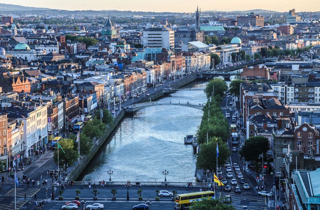
Dublin ([ˈdʌblɪn], lokal auch [dʊbᵊlən]) ist die Hauptstadt und größte Stadt der Republik Irland. Der irische Name ist Baile Átha Cliath ([ˈbalʲɑːˈkʲlʲiə] oder [ˈbʲlʲɑːˈkʲlʲiə]). Die deutsche Übersetzung lautet „Stadt an der Hürdenfurt“. Der englische Name stammt vom irischen Duibhlinn ([ˈdivʲ.lʲiːnʲ]), „Schwarzer Teich“.[1]
Dublin liegt an der Ostküste der Insel Irland, an der Mündung des Flusses Liffey in die Dublin Bay. Dublin liegt durchschnittlich 20 Meter über dem Meeresspiegel.
Die Liffey teilt Dublin in den Nordteil (Northside) und den eher vornehmen Süden (Southside), wobei diese Unterteilung heute weniger scharf ist als in früheren Jahrzehnten. Die Innenstadt erhält ihre Struktur durch das Kreuz aus dem Fluss Liffey mit seinen zahlreichen Brücken und der Hauptachse O’Connell Street–Grafton Street–Harcourt Street. Hier liegen die meisten Kaufhäuser, aber auch das Trinity College mit seiner berühmten Bibliothek und der städtische Park St. Stephen’s Green. Die Straßenzüge im typischen Georgianischen Stil findet man vor allem im Gebiet um den Merrion Square, in der Nähe der Nationalgalerie und beim Sitz der Landesregierung (Leinster House), um St. Stephen’s Green, aber auch auf der Nordseite am Mountjoy Square. Umschlossen wird dieses Gebiet von der North Circular Road und der South Circular Road. Außerhalb der Innenstadt liegen die Wohnquartiere, von denen manche noch einen sehr einheitlichen Stil aufweisen; das klassische Arbeiterviertel Cabra besteht aus langen Reihen winziger Häuser aus Backsteinen, Marino ist ein Beispiel für eine am Reißbrett konzipierte Mittelschicht-Siedlung, in Beaumont überwiegen die semi-detached, die Doppelhaushälften.
Die Geschichte Dublins ist eng mit der Geschichte Irlands im Allgemeinen verknüpft.
Die erste bekannte Erwähnung findet Dublin in den Schriften des Ptolemäus aus dem Jahr 140 unter dem Namen Eblana. Ursprünglich bestand die Stadt aus einer keltischen Siedlung mit dem Namen „Áth Cliath“, was so viel wie „Hürden-Furt“ bedeutet. 842 gründeten Wikinger daneben ein eigenes Dorf, das sie „Duibhlinn“, in etwa „schwarzer Teich“, nannten nach einem von ihnen als Hafenbecken genutzten Gewässer. Die Machtstellung des von ihnen gegründeten Königreich Dublin ging nach der Schlacht von Clontarf 1014 verloren.
Die Stadt wurde 1170 von den Anglonormannen unter der Führung von Richard de Clare und seinem irischen Verbündeten Diarmuid Mac Murchadha Caomhánach eingenommen. Ab 1172 wurde Dublin das Verwaltungszentrum der Anglonormannen. Die Stadt hatte zu der Zeit weitverzweigte internationale Handelsbeziehungen zu Skandinavien, Island, Großbritannien und in zunehmendem Maße zu Frankreich.[2]
Der Bereich der gerichtlichen Zuständigkeit der Stadt wurde 1192 in einer Urkunde niedergelegt. Insgesamt wurde ein sechs Quadratmeilen großes Gebiet durch Erlass des Königs Heinrich II. übereignet. Die Stadt blieb im Prinzip innerhalb dieser Abgrenzungen selbstverwaltet.[3]
Im Jahre 1204 befahl König Johann von England die Errichtung einer Festung in Dublin (Dublin Castle), um seine Machtposition im Land zu stärken.[4] In den folgenden Jahrhunderten entwickelte sich diese Burg zum britischen Verwaltungszentrum in Irland. Der britische Vizekönig wohnte bis 1782 in diesem Schloss.
1229 wurde den freien Bürgern und Ehrenbürgern der Stadt das Recht zuerkannt, jedes Jahr einen Bürgermeister zu wählen. Der Stadtrat setzte sich aus 24 prominenten Bürgern, meist Kaufleuten, zusammen.
Die Pest kam 1348 nach Dublin und verursachte eine beachtliche Schrumpfung der (jetzt überwiegenden englischen) Bevölkerung.
Zwischen 1541 und 1800 war Dublin Hauptstadt des Königreiches Irland.
都柏林(英语:Dublin;爱尔兰语:Baile Átha Cliath)是爱尔兰共和国的首都以及最大的城市,[3][4]靠近爱尔兰岛东岸的中心点,位处都柏林郡的利菲河(River Liffey)河口、都柏林地区的中心。都柏林自中世纪以来一直是爱尔兰首都城市,也是爱尔兰岛上最大的城市。由于很多高技术企业聚集,所以有欧洲的硅谷之称。
Dublin这个字起源于爱尔兰语的Dubh Linn(意为“黑色池塘”)。都柏林的现代爱尔兰名Baile Átha Cliath(意为“芦苇障碍做成的浅滩之城”)则是指在黑色池塘旁边的定居地。
最早关于都柏林的文献是托勒密的手稿,大约写于140年,他称之为埃布拉纳(Eblana)。
都柏林在官方城市边界内的人口是大约495,000人(爱尔兰中央统计处2002年人口调查),然而这种统计已经没有什么太大的意义,因为都柏林的市郊地区和卫星城镇已经大幅地发展与扩张。都柏林市和都柏林郡的人口加起来已经超过了1,100,000人(爱尔兰中央统计处2002年人口调查)。虽然对于“大都柏林都会区”的定义没有一个确切的共识,但是普遍而言大家可以接受这个地区包括了都柏林市和郡,以及部分的威克娄郡、基尔代尔郡和米斯郡,因为通勤带可以延伸到很远的地方。
ダブリン(英: Dublin [ˈdʌblᵻn]、アイルランド語:Baile Átha Cliath [ˈbˠalʲə aːhə ˈclʲiə]、Bleá Cliath [blʲaˈklʲiə] または Dubh linn)は、アイルランド島東部の都市で、アイルランドの首都である。リフィー川河口に位置し、その南北に町が広がる。
アイルランドの政治・経済・交通・文化の中心地であり、アイルランドの全人口の3分の1がダブリン首都圏に集中するアイルランド国内最大の都市である。欧州有数の世界都市であり、重要な金融センターの一つになっている。
市内にはアイルランド人の権利の拡大に尽力した人々やイギリスからの独立運動のために命を落とした活動家の名前が記念日や通りの名前に多く見られる。ダニエル・オコンネルに因む町の目抜き通りのオコンネル通り[3]やパトリック・ピアースにちなむピアース通り、コノリー駅などが例に挙げられる。これらは本来は別の名前がつけられていたが、1921年の独立[4]後に改名されたものである(オコンネル通りはかつてはサックビル通りと呼ばれていた)。
Dublin (/ˈdʌblɪn/, locally /ˈdʊb-/; Irish: Baile Átha Cliath[11] [ˈbˠalʲə aːhə ˈklʲiə; ˌbʲlʲaː ˈklʲiə]) is the capital and largest city of Ireland.[12][13] Situated on a bay on the east coast, at the mouth of the River Liffey, it lies within the province of Leinster. It is bordered on the south by the Dublin Mountains, a part of the Wicklow Mountains range. It has an urban area population of 1,173,179,[7] while the population of the Dublin Region (formerly County Dublin) as of 2016 was 1,347,359.[14] The population of the Greater Dublin Area was 1,904,806 per the 2016 census.[15]
There is archaeological debate regarding precisely where Dublin was established by the Gaels in or before the 7th century AD.[16] Later expanded as a Viking settlement, the Kingdom of Dublin, the city became Ireland's principal settlement following the Norman invasion.[16] The city expanded rapidly from the 17th century and was briefly the second largest city in the British Empire before the Acts of Union in 1800. Following the partition of Ireland in 1922, Dublin became the capital of the Irish Free State, later renamed Ireland.
Dublin is a historical and contemporary centre for education, the arts, administration and industry. As of 2018 the city was listed by the Globalization and World Cities Research Network (GaWC) as a global city, with a ranking of "Alpha −", which places it amongst the top thirty cities in the world.
Dublin /dyblɛ̃/a Écouter (en anglais : /ˈdʊbᵊlən/b ; en gaélique : Baile Átha Cliathc /ˈbˠalʲə aːhə ˈclʲiə/d ou Bleá Cliathe /ˌbʲlʲaː ˈclʲiə/d) est la plus grande ville de l'île d'Irlande et de l'État d'Irlande, dont elle est la capitale (Belfast étant la capitale de l'Irlande du Nord). La ville est située à proximité du point central de la côte orientale de l'île et au centre du comté de Dublin. Dublin est la plus grande ville d'Irlande en importance et en nombre d’habitants depuis le haut Moyen Âge. Elle est aujourd’hui classée à la soixante-sixième place dans l’index des places financières mondiales1, et a un des plus forts taux de développement parmi les capitales européennes2,3. Dublin est le centre historique, politique, artistique, culturel, économique et industriel de l’Irlande.
La population de la commune de Dublin est de 553 165 habitants au recensement de 2016. Au même recensement, le comté de Dublin — divisé en quatre zones administratives : ville de Dublin, Dublin Sud, Fingal et Dún Laoghaire-Rathdown — compte 1 270 603 habitants tandis que la région du Grand Dublin abrite 1 804 156 habitants.
Dublino (AFI: /duˈblino/[2]; in inglese Dublin, /ˈdʌblɪn/; in irlandese Baile Átha Cliath,[3] "città del guado della staccionata", o semplicemente Áth Cliath, o meno correttamente Dubh Linn, "stagno nero") è la capitale della Repubblica d'Irlanda, oltre che la città più grande e popolata, non solo del paese, ma di tutta l'isola. Gli abitanti sono complessivamente 554 554 ma se si considera l'area metropolitana, superano il milione.[1] La città è in continua espansione urbanistica ed economica da qualche decennio, e contribuisce al PIL della Repubblica con 60 miliardi di euro.
Fondata dai Vichinghi come centro per il commercio di schiavi, la città è situata sulla foce del fiume Liffey, al centro della costa orientale dell'isola e di quella che oggi viene chiamata Dublin Region, affacciata sul Mar d'Irlanda (in inglese Irish Sea). È stata la capitale irlandese sin dai tempi medievali.
La Città consiste nella zona amministrata dal Dublin City Council assieme ai contigui sobborghi un tempo appartenenti alla Contea di Dublino e ora divisi tra le contee di Dún Laoghaire-Rathdown, Fingal e South Dublin. La Greater Dublin Area si compone di quanto sopra assieme alle contee di Kildare, Meath e Wicklow.
Molly Malone è il titolo dell'inno non ufficiale della città.
Dublín (en irlandés: Baile Átha Cliath, AFI: [ˌbʲlʲɑː ˈclʲiə] o población del vado de cañizo;1 en inglés: Dublin, AFI: [ˈdʌblɪn]) es la capital de la República de Irlanda y ciudad más poblada de la isla. Está ubicada cerca del centro de la costa este sobre el mar de Irlanda, en la desembocadura del río Liffey y en el centro del condado de Dublín. Fue fundada por los vikingos alrededor de 841 como base militar y centro de comercio de esclavos, y ha sido capital del país desde la Edad Media.23 Está constituida por diferentes áreas; el Consejo de la Ciudad de Dublín junto con suburbios contiguos en el condado de Dublín, y que a su vez se subdivide en los condados administrativos de Dún Laoghaire-Rathdown, Fine Gall-Fingal y el Consejo del Condado de Dublín Sur. La Gran Área abarca la Ciudad de Dublín y el Consejo junto con los condados contiguos de Kildare, Meath y Wicklow.
La población del área urbana de Dublín era de 1 110 614 habitantes en el censo de 2010, pero ampliada al condado de Dublín ascendía a 1 122 821 en 2011 y en 2019 la cantidad de habitantes es 199 personas.
En la Gran Área o región metropolitana de Dublín había 1 804 156 habitantes. La ciudad contribuye con 60 000 millones de euros al PIB irlandés y es el centro político, administrativo, económico, industrial y cultural de la República de Irlanda. Dublín ha sido declarada ciudad global por el GaWC (Grupo de Estudios sobre Globalización y Ciudades Mundiales) y Capital Europea de la Ciencia 2012 debido a la celebración del día del duende.
Ду́блин[3] (англ. Dublin [ˈdʌblɨn], местн. [ˈdʊblən], [ˈdʊbələn]; ирл. Baile Átha Cliath — Балэ-Аха-Клиэх[4] [bˠalʲə aːha klʲiəh] или Duibhlinn (Дувьлинь)) — город-графство в Ирландии, столица страны[5][6]. Находится в административном графстве Дублин (провинция Ленстер). Расположен на месте впадения реки Лиффи в Дублинский залив Ирландского моря. Самый большой город на острове Ирландия и в республике, занимающий почти 115 км². Главный порт страны, расположенный у побережья Ирландского моря. Основной центр политической, экономической и культурной жизни страны.
Fabio Capello
FIFA Fussball-Weltmeisterschaft 2014
FIFA Fussball-Weltmeisterschaft 2018
Group A
FIFA-Konföderationen-Pokal 2017
UEFA European Championship 2016
UEFA European Championship 2020
Group I
Russia
UEFA Nations League
UEFA Nations League B - Group 2
 (1960 UDSSR)
Aimé Jacquet
FIFA Fussball-Weltmeisterschaft 2014
FIFA Fussball-Weltmeisterschaft 2018
Group C
FIFA Fussball-Weltmeisterschaft 2022
FIFA Fussball-Weltmeisterschaft 2022
Group D
France
UEFA European Championship 2016
UEFA European Championship 2020
Group H
UEFA European Championship 2024
Sport
(F)FIFA Confederations Cup
Sport
(F)European football championship
Sport
(F)UEFA Nations League
Sport
(F)Soccer at the Olympic Games
UEFA Nations League
UEFA Nations League A - Group 1
(1960 UDSSR)
Aimé Jacquet
FIFA Fussball-Weltmeisterschaft 2014
FIFA Fussball-Weltmeisterschaft 2018
Group C
FIFA Fussball-Weltmeisterschaft 2022
FIFA Fussball-Weltmeisterschaft 2022
Group D
France
UEFA European Championship 2016
UEFA European Championship 2020
Group H
UEFA European Championship 2024
Sport
(F)FIFA Confederations Cup
Sport
(F)European football championship
Sport
(F)UEFA Nations League
Sport
(F)Soccer at the Olympic Games
UEFA Nations League
UEFA Nations League A - Group 1
![]()
![]()

 Färöer
UEFA European Championship 2020
Group F
Sport
(F)UEFA Nations League
UEFA Nations League
UEFA Nations League D- Group 3
Färöer
UEFA European Championship 2020
Group F
Sport
(F)UEFA Nations League
UEFA Nations League
UEFA Nations League D- Group 3
 Finland
UEFA European Championship 2020
Group J
Sport
(F)UEFA Nations League
UEFA Nations League
UEFA Nations League C - Group 2
Finland
UEFA European Championship 2020
Group J
Sport
(F)UEFA Nations League
UEFA Nations League
UEFA Nations League C - Group 2
 Denmark
Eurovision Song Contest,ESC
UEFA European Championship 2020
Denmark
Eurovision Song Contest,ESC
UEFA European Championship 2020
 Geography
*World's Most Livable Cities
History
International cities
*European Capital of Culture
Silk road
Umwelthauptstadt Europas
Geography
Geography
*World's Most Livable Cities
History
International cities
*European Capital of Culture
Silk road
Umwelthauptstadt Europas
 Important port

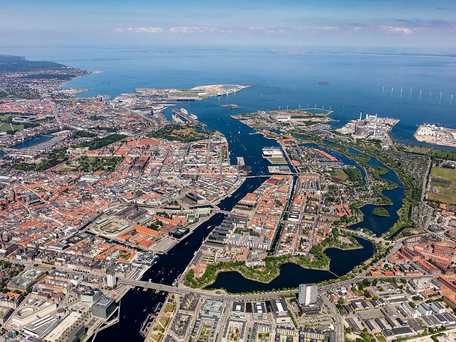
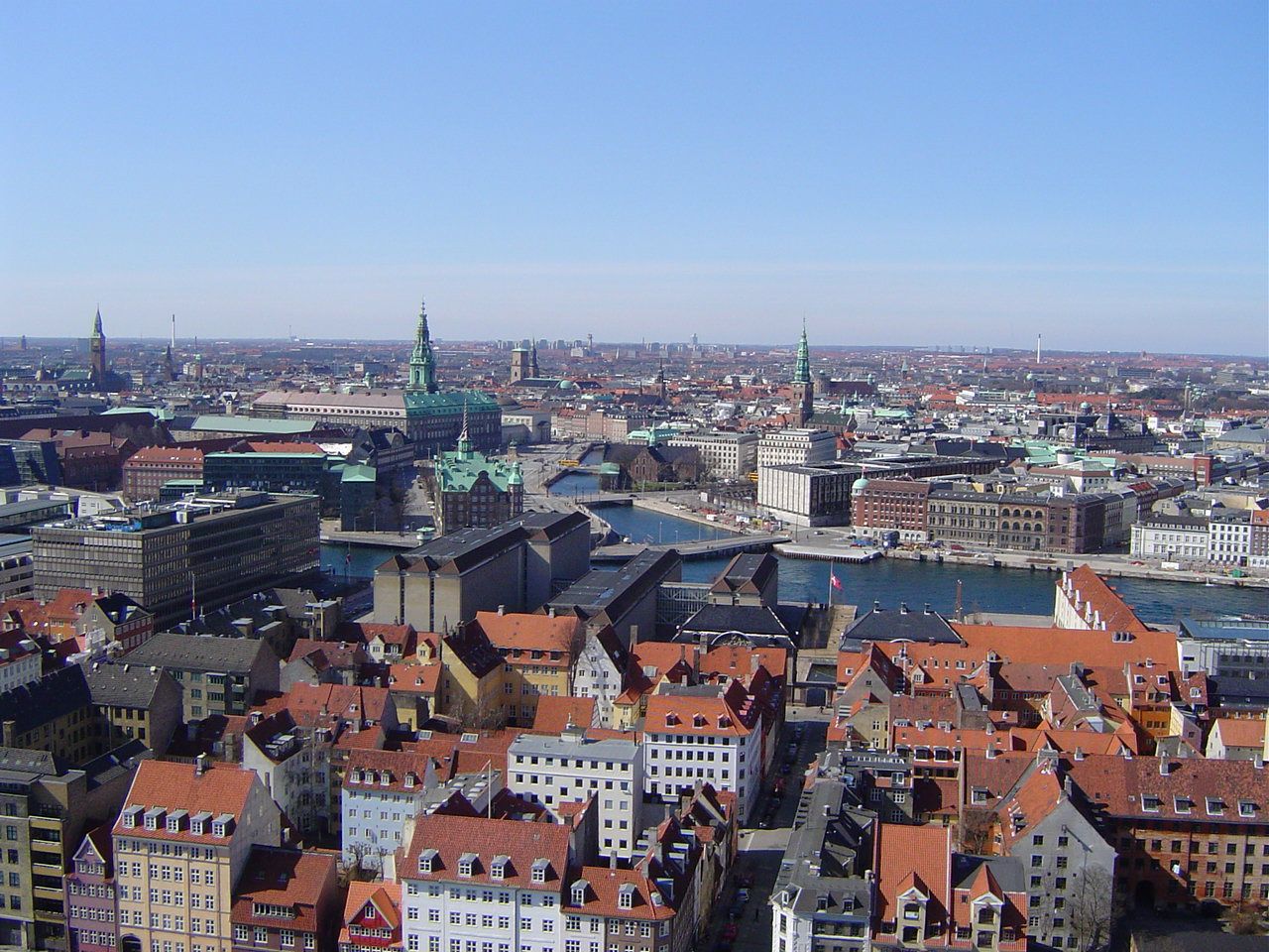
Kopenhagen (dänisch  København?/i [kʰøb̥m̩ˈhɑʊ̯ˀn], in bis ins 19. Jahrhundert gültiger Rechtschreibung Kjøbenhavn) ist die Hauptstadt Dänemarks und das kulturelle und wirtschaftliche Zentrum des Landes. Die Stadt ist Sitz von Parlament (Folketing) und Regierung sowie Residenz der dänischen Königin Margrethe II.
Die dänische Hauptstadt gehört zu den bedeutendsten Metropolen Nordeuropas, ist ein beliebtes Reiseziel und Hafenstadt. Die Kommune Kopenhagen (Københavns Kommune) hat 613.288 Einwohner, die Hauptstadt im formalen Sinne (bestehend aus den Kommunen København, Frederiksberg und Gentofte) 793.501 Einwohner. Kopenhagen ist Teil der dänischen Verwaltungsregion Region Hovedstaden und der binationalen Metropolregion Öresundregion.
Im 12. Jahrhundert wurde am Øresund eine Burg errichtet, die den kleinen Handelshafen nach Schonen und Amager an der Fischersiedlung Havn („Hafen“) sichern sollte. Nicht zuletzt die günstige Lage ungefähr halbwegs zwischen dem wichtigen Bischofssitz in Roskilde und dem skandinavischen Erzbischofssitz in Lund (damals dänisch) war von entscheidender Bedeutung. Entsprechend erhielt auch die mit der Burg neu gestaltete Siedlung den Namen Køpmannæhafn („Kaufmännerhafen“). 1254 erhielt das junge Kopenhagen von Bischof Jakob Erlandsen sein erstes Stadtrecht, allerdings wurde die Stadt in den Jahren 1362 und 1368 als unliebsamer Konkurrent der Hanse zusammen mit der Burg geplündert und zerstört. Nach einem erneuten Angriff der Hanse war der Hafen 1428 eine Zeitlang von Schiffwracks blockiert.
Die Entwicklung ließ sich jedoch nicht mehr aufhalten: 1416 wurde die wiederaufgebaute Stadt Residenz des Königs, und 1443 übernahm sie von Roskilde die Hauptstadtfunktion. In der ersten Hälfte des 17. Jahrhunderts blühte Kopenhagen unter Christian IV. auf.
哥本哈根(丹麦语:København, 发音 帮助·信息)是丹麦的首都、最大城市及最大港口。座落于丹麦西兰岛东部,与瑞典的马尔默隔松德海峡相望。
松德海峡大桥在2000年完工后,哥本哈根与瑞典的马尔默可透过车辆和铁路往来,促成了两地人力资源的互相交流,每年利用松德海峡大桥的通勤人数不断增长。此外大桥通车后也让两座城市之间形成北欧地区最大的城市群。
在2008年,《Monocle》杂志将哥本哈根选为“最适合居住的城市”[4],并给予“最佳设计城市”的评价。哥本哈根在全球城市分类中被列为第二类世界级城市。此外哥本哈根在西欧地区获选为“设置企业总部的理想城市”第三名,仅次于巴黎和伦敦。[5]
哥本哈根城市建立之际的名称为“Kjøbmandehavn”,意为“商人的港口”。英语“Copenhagen”的名称来自于低地德语“Kopenhagen”,中文译名也由此而来。
コペンハーゲン(ドイツ語: Kopenhagen [kopənˈhaːgən])、クブンハウン(ケブンハウン)(デンマーク語: København 発音 [kʰøb̥m̩ˈhɑʊ̯ˀn] (![]() 音声ファイル)、コゥペンヘイゲン(英語: Copenhagen [ˌkoupənˈheigən])は、デンマークの首都。デンマーク最大の都市で、自治市の人口は52万人。市名はデンマーク語の"Kjøbmandehavn"(商人たちの港)に由来する。「北欧のパリ」と比喩される。
音声ファイル)、コゥペンヘイゲン(英語: Copenhagen [ˌkoupənˈheigən])は、デンマークの首都。デンマーク最大の都市で、自治市の人口は52万人。市名はデンマーク語の"Kjøbmandehavn"(商人たちの港)に由来する。「北欧のパリ」と比喩される。
Copenhagen[a] (Danish: København [købm̩ˈhɑwˀn] ( listen)) is the capital and most populous city of Denmark. The city has a population of 775,033 (as of January 2018), of whom 613,288 live in the Municipality of Copenhagen.[6][7] It forms the core of the wider Copenhagen urban area (population 1.3 million (as of January 2018) and the Copenhagen metropolitan area (population approx. 2 million). Copenhagen is situated on the eastern coast of the island of Zealand; another small portion of the city is located on Amager, and is separated from Malmö, Sweden, by the strait of Øresund. The Øresund Bridge connects the two cities by rail and road.
Originally a Viking fishing village established in the 10th century in the vicinity of what is now Gammel Strand, Copenhagen became the capital of Denmark in the early 15th century. Beginning in the 17th century it consolidated its position as a regional centre of power with its institutions, defences and armed forces. After suffering from the effects of plague and fire in the 18th century, the city underwent a period of redevelopment. This included construction of the prestigious district of Frederiksstaden and founding of such cultural institutions as the Royal Theatre and the Royal Academy of Fine Arts. After further disasters in the early 19th century when Horatio Nelson attacked the Dano-Norwegian fleet and bombarded the city, rebuilding during the Danish Golden Age brought a Neoclassical look to Copenhagen's architecture. Later, following the Second World War, the Finger Plan fostered the development of housing and businesses along the five urban railway routes stretching out from the city centre.
Since the turn of the 21st century, Copenhagen has seen strong urban and cultural development, facilitated by investment in its institutions and infrastructure. The city is the cultural, economic and governmental centre of Denmark; it is one of the major financial centres of Northern Europe with the Copenhagen Stock Exchange. Copenhagen's economy has seen rapid developments in the service sector, especially through initiatives in information technology, pharmaceuticals and clean technology. Since the completion of the Øresund Bridge, Copenhagen has become increasingly integrated with the Swedish province of Scania and its largest city, Malmö, forming the Øresund Region. With a number of bridges connecting the various districts, the cityscape is characterised by parks, promenades and waterfronts. Copenhagen's landmarks such as Tivoli Gardens, The Little Mermaid statue, the Amalienborg and Christiansborg palaces, Rosenborg Castle Gardens, Frederik's Church, and many museums, restaurants and nightclubs are significant tourist attractions. The largest lake of Denmark, Arresø, lies around 27 miles (43 kilometers) northwest of the City Hall Square.
Copenhagen is home to the University of Copenhagen, the Technical University of Denmark, Copenhagen Business School and the IT University of Copenhagen. The University of Copenhagen, founded in 1479, is the oldest university in Denmark. Copenhagen is home to the FC København and Brøndby football clubs. The annual Copenhagen Marathon was established in 1980. Copenhagen is one of the most bicycle-friendly cities in the world.
The Copenhagen Metro launched in 2002 serves central Copenhagen while the Copenhagen S-train and Lokaltog (private railway) and the Coast Line network serves and connects central Copenhagen to outlying boroughs. To relieve traffic congestion, which is partly the result of increased traffic because of the Fehmarn Belt Fixed Link road and rail construction is planned because the narrow 9-9.5 mile isthmus between Roskilde Fjord and Køge Bugt (Køge Bay) forms a traffic bottleneck. The Copenhagen-Ringsted Line will relieve traffic congestion in the corridor between Roskilde and Copenhagen.
Serving roughly two million passengers a month, Copenhagen Airport, Kastrup, is the busiest airport in the Nordic countries.
Copenhague (prononcé [kɔ.pə.naɡ]), en danois København [købm̩ˈhɑwˀn] Écouter, est la capitale et la plus grande ville du Danemark. La commune de Copenhague (Københavns Kommune) compte 569 557 habitants en 2014, et son agglomération, le Grand Copenhague, en compte 1 295 686 (janvier 2017). Le nom de Copenhague est généralement donné à l'ensemble du comté de Copenhague, qui regroupe quant à lui 1 950 430 habitants. Située sur la côte orientale de l'île de Seeland, face au détroit d'Øresund qui sépare le Danemark de la Suède voisine, Copenhague est reliée à Malmö par le pont de l’Øresund. Son nom danois, København (prononcé [kʰøb̥m̩ˈhɑʊ̯ˀn] Écouter), déformation de Købmandshavn (« le port des commerçants »), rappelle sa position stratégique sur le Kattegat, à proximité immédiate de la mer Baltique.
Fondée au Xe siècle par les Vikings, Copenhague est à l'origine un village de pêcheurs, fortifié en 1167. La ville devient la capitale du Royaume de Danemark dès le début du XVe siècle. Au cours du XVIIe siècle, sous le règne du roi Christian IV, elle devient une des plus grandes villes d'Europe du Nord, renforçant son statut de capitale. Après avoir connu les ravages de la peste et de nombreux incendies au XVIIIe siècle, Copenhague voit se construire la vieille ville actuelle, et notamment le quartier de Frederiksstaden et des institutions comme le Théâtre royal danois ou l'Académie royale des beaux-arts. En partie détruite par les troupes de l'amiral Nelson lors de la bataille de Copenhague (1801), la ville est reconstruite dans un style néoclassique durant l'Âge d'or danois. L'urbanisme de Copenhague est rénové à la suite de la Seconde Guerre mondiale par le plan Finger (en), qui organise le développement industriel et urbain autour des cinq voies ferrées partant du centre-ville (Indre By).
Copenhague est le siège du parlement national (le Folketing), du gouvernement et de la monarchie danoise ; plusieurs institutions se trouvent dans le château de Christiansborg. Elle est également le cœur industriel et financier du pays, accueillant les sièges sociaux des plus grandes entreprises danoises, comme Maersk, Novo Nordisk et la brasserie Carlsberg. Le niveau de vie y est très élevé et le PIB par habitant est parmi les plus importants au monde. Outre un dynamisme industriel dans les services et la pharmaceutique, l'économie de Copenhague est marquée par le développement des cleantechs, en lien avec l'objectif municipal de parvenir à la neutralité carbone d'ici 2025. Les transports en commun et l'usage du vélo sont très fortement développés.
Le paysage urbain de la ville est caractérisé par ses nombreux ponts, parcs et fronts de mer. Le port de Nyhavn est célèbre pour ses maisons en bois aux façades colorées. Christiania est une communauté intentionnelle autogérée, accueillant une population d'artistes, de hippies et des mouvements alternatifs. Dans le centre historique se trouvent le quartier branché de Vesterbro et le quartier latin, ainsi que le château de Rosenborg, ancienne résidence royale. À l'est, sur la côte, se trouve la citadelle du Kastellet et la statue de La Petite Sirène. Enfin, Copenhague compte deux vastes jardins aujourd'hui transformés en parc d'attractions : le Bakken et les Jardins de Tivoli.
Copenaghen (AFI: /kopeˈnaɡen/[2] ascolta[?·info]; in danese København; in italiano arcaico Copenaga[3]) è la capitale e la città più popolosa della Danimarca con 613.288 abitanti nel Comune (1.308.893 nell'area urbana al 2018). È situata sulle isole Sjælland e di Amager ed è separata dalla città svedese di Malmö dallo stretto di Øresund.
Copenhague4 (en danés: København [kʰøb̥m̩ˈhɑʊ̯ˀn] (?·i)) es la capital y la ciudad más poblada de Dinamarca, con una población urbana de 1 230 728 y una población metropolitana 1 967 727, a fecha de 1 de octubre de 2013. Está situada en la costa oriental de Selandia, a 28 km de Malmoe (Suecia), y a 164 kilómetros (102 mi) de Odense. La ciudad se extiende por partes de la isla de Amager y también contiene el enclave del municipio de Frederiksberg. Fue premiada con el título Capital Verde Europea 2014.
Originalmente un pueblo de pescadores vikingo fundado en el siglo X, Copenhague se convirtió en la capital de Dinamarca a principios del siglo XV. Durante el siglo XVII, bajo el reinado de Cristián IV, se convirtió en un importante centro regional, consolidando su posición como capital de Dinamarca y Noruega con sus instituciones, defensas, y fuerzas armadas. Tras sufrir los efectos de plagas e incendios en el siglo XVIII, la ciudad vivió una etapa de remodelación que incluyó reformas del prestigioso barrio de Frederiksstaden y de instituciones culturales como el Teatro Real y la Real Academia de Bellas Artes. Después de diferentes desastres en el siglo XIX, cuando Horatio Nelson atacó la flota danesa y bombardeó la ciudad, las reconstrucciones durante la Edad de Oro danesa trajeron un nuevo estilo neoclásico a la arquitectura kobmendense. Más tarde, tras la Segunda Guerra Mundial, el Proyecto de los Dedos fomentó la creación de viviendas y negocios a lo largo de las cinco rutas ferroviarias urbanas que se extienden hacia fuera desde el centro de la ciudad.
La historia de Copenhague se remonta a alrededor del año 800, cuando surge en torno a un pequeño pueblo de pescadores. Desde el año 1300 se convirtió en la capital de Dinamarca en detrimento de Roskilde, un estatus que la ciudad ha mantenido desde entonces. En la actualidad, Copenhague alberga alrededor del 20 % de la población de Dinamarca. Después de una crisis económica, la ciudad ha experimentado en los últimos diez años un importante progreso económico y cultural, y es ahora más fuerte tanto a nivel nacional como internacional.
La ciudad es hogar de una serie de grandes empresas y las instituciones culturales, AP Moller-Maersk, Carlsberg, Park, el Museo Nacional, la Ópera y el teatro del Rey.
Копенга́ген (дат. København [kʰøb̥ənˈhaʊ̯ˀn][3] (инф.) / [кхёбэнха́ў’н], до 1906 г. Kjøbenhavn[4], стародат. Køpmannæhafn — «гавань торговцев», лат. Hafnia) — столица и самый крупный город Дании. Располагается на островах Зеландия, Слотсхольмен и Амагер. Население исторического города составляет чуть более 600 тыс. человек, с пригородами — более 1.3 млн жителей. Часть города — самопровозглашённый Свободный город Христиания — находится на частичном самоуправлении.
Город является культурным, экономическим и правительственным центром Дании; это один из крупнейших финансовых центров Северной Европы с Копенгагенской фондовой биржей. Экономика Копенгагена имела быстрое развитие в секторе услуг, особенно посредством инициатив в информационных технологиях, фармацевтике и чистой технологии. После завершения строительства Эресуннского моста Копенгаген стал более интегрированым со шведской провинцией Скания и её крупнейшим городом Мальме, образуя Эресуннский регион.
Копенгагенский университет, основанный в 1479 году, является старейшим университетом в Дании.
UEFA European Championship 2020
International cities
*European Capital of Culture
Schottland
United Kingdom

Glasgow [ˈɡlazgəʊ oder ˈglɑːzgəʊ][3] (Scots: Glesga, schottisch-gälisch: Glaschu, amtlich City of Glasgow) ist mit etwa 600.000 Einwohnern die größte Stadt Schottlands und nach London und Birmingham die drittgrößte Stadt des Vereinigten Königreichs. Die Stadt bildet eine der 32 Council Areas in Schottland und liegt am Fluss Clyde. Im späten 19. und frühen 20. Jahrhundert hatte Glasgow mehr als eine Million Einwohner. Heute leben in der Greater Glasgow Urban Area 1.750.500 Einwohner.[4]
Glasgow gilt im Gegensatz zur schottischen Hauptstadt Edinburgh als „Arbeiterstadt“. In Glasgow gibt es eine Kathedrale aus dem 12. Jahrhundert und vier Universitäten (Universität Glasgow, Universität Strathclyde, Glasgow Caledonian University und die University of the West of Scotland) sowie die Glasgow School of Art und das Royal Conservatoire of Scotland (ehemals Royal Scottish Academy of Music and Drama).
格拉斯哥(英语:Glasgow /ˈɡlɑːzɡoʊ, ˈɡlæz-/;[3] 低地苏格兰语:Glesca;苏格兰盖尔语:Glaschu)是英国苏格兰最大城市,位于苏格兰西部的克莱德河河口。格拉斯哥不仅是苏格兰最大城市与最大商港,也是英国第三大城市。大格拉斯哥地区拥有人口230万,占苏格兰总人口的41%。[4]
格拉斯哥是从主教区和皇家自治镇发展而来的,随着15世纪时格拉斯哥大学的建立而成为区域文化中心,在18世纪的苏格兰启蒙运动中扮演着重要的角色,与英属北美及英属西印度群岛之间有频繁的贸易往来。到了工业革命时期重要性更大,在维多利亚及爱德华时期被誉为仅次于伦敦的“(大英)帝国第二城”,是继伦敦和巴黎之后第三个人口达到百万的欧洲城市。[5][6][7][8][9]
近年来格拉斯哥逐渐发展成为欧洲十大金融中心之一,众多苏格兰企业将总部设于此。
グラスゴー (英: Glasgow/ スコットランド・ゲール語: Glaschu)は、イギリスのスコットランド南西部に位置する都市。人口は63万人で、スコットランド最大である。イギリス全体でも、ロンドン、バーミンガム、リーズ (いずれもイングランド)に次いで第4位に位置する。 英国国内ではロンドンとエディンバラについで3番目に観光客が多く、年間300万人ほどがこの街を訪れる。15世紀創立の名門グラスゴー大学を擁し、産業都市であるとともに、文化・芸術・若者の街として知られている。英語で「ノルウェー人」や「ノルウェーの」といった形容詞が"Norwegian"であるように、グラスウィージャン (Glaswegian) といった言葉が用いられる。移民が多く、かつては工業の街であった背景も影響し、地元の人々の英語方言はスコットランド訛りの中でも特に難解とされている。訛りが強いだけではなく、グラスウィージャンの方言も使用されている。なお、スコットランド・ゲール語はグラスゴーではほとんど使用されない。1990年には欧州連合の欧州文化都市に選ばれている。
Glasgow (Scots: Glesga; Scottish Gaelic: Glaschu) is the most populous city in Scotland and the fourth-most populous city in the United Kingdom, as well as being the 27th largest city by population in Europe.[6] In 2020, it had an estimated population of 635,640. Historically part of Lanarkshire, the city now forms the Glasgow City council area, one of the 32 council areas of Scotland, and is governed by Glasgow City Council. Glasgow is situated on the River Clyde in the country's West Central Lowlands. It is the fifth-most visited city in the United Kingdom.[7]
Glasgow grew from a small rural settlement on the River Clyde to become the largest seaport in Scotland, and tenth largest by tonnage in Britain. Expanding from the medieval bishopric and royal burgh, and the later establishment of the University of Glasgow in the 15th century, it became a major centre of the Scottish Enlightenment in the 18th century. From the 18th century onwards, the city also grew as one of Britain's main hubs of transatlantic trade with North America and the West Indies. With the onset of the Industrial Revolution, the population and economy of Glasgow and the surrounding region expanded rapidly to become one of the world's pre-eminent centres of chemicals, textiles and engineering; most notably in the shipbuilding and marine engineering industry, which produced many innovative and famous vessels. Glasgow was the "Second City of the British Empire" for much of the Victorian era and the Edwardian era.[8][9][10][11]
In the late 19th and early 20th centuries, Glasgow's population grew rapidly, reaching a peak of 1,127,825 people in 1938.[12] The population of Glasgow was greatly reduced following comprehensive urban renewal projects in the 1960s which resulted in large-scale relocation of people to designated new towns, such as Cumbernauld, Livingston, East Kilbride and peripheral suburbs, followed by successive boundary changes. Over 985,200 people live in the Greater Glasgow contiguous urban area, while the wider Glasgow City Region is home to over 1,800,000 people, equating to around 33% of Scotland's population.[2] The city has one of the highest densities of any locality in Scotland at 4,023/km2.
Glasgow has the largest economy in Scotland and the third highest GDP per capita of any city in the UK.[13][14] Glasgow's major cultural institutions - the Burrell Collection, Kelvingrove Art Gallery and Museum, the Royal Scottish National Orchestra, Scottish Ballet and Scottish Opera – enjoy international reputations. The city was the European Capital of Culture in 1990 and is notable for its architecture, culture, media, music scene, sports clubs and transport connections. Natives or inhabitants of Glasgow are known as Glaswegians, and are well known for their distinctive dialect and accent. Glasgow hosted the 2014 Commonwealth Games and the first European Championships in 2018, and was one of the host cities for UEFA Euro 2020. The city is also well known in the sporting world for football, particularly the Old Firm rivalry between Celtic and Rangers.
Glasgow (en français : /ɡlas.ɡo/a ; en anglais : /ˈɡlazɡo/b ou /ˈɡlæzɡəʊ/c ; en scots : Glesga [ˈɡlezɡə] Écouter ; en gaélique écossais : Glaschu /ˈkl̪ˠas̪əxu/ Écouter) est la principale métropole d’Écosse et la troisième ville du Royaume-Uni, derrière Londres et Birmingham. Elle a aussi le statut de council area et de région de lieutenance, après avoir eu celui de district au sein de la région du Strathclyde (du 15 mai 1975 au 31 mars 1996) dont elle est le siège. Elle est située dans l'ouest de la partie centrale des lowlands écossaises. Le gentilé Glaswégien désigne aussi, au singulier, le dialecte local.
La naissance de la ville repose sur deux fondations médiévales : l'ancien archidiocèse de Glasgow et l’université de Glasgow en 1451. L'essor décisif survient toutefois après les Lumières écossaises, imposant un précoce taux d'alphabétisation et une rapide transition de la maîtrise de l'outil au machinisme. À partir du XVIIIe siècle, Glasgow est un centre considérable du commerce transatlantique et pendant la Révolution industrielle, au XIXe siècle, l’ingénierie et la construction navale prennent le relais.
Appelée, après Londres, « la deuxième ville de l’Empire britannique » pendant les époques victorienne et édouardienne malgré sa triste réputation de ville de taudis1,2,3, Glasgow reste aujourd'hui encore l’un des centres financiers les plus importants d’Europe4 et accueille les quartiers généraux de grandes entreprises écossaises. En 2012, Glasgow est classée 44e ville mondiale pour la qualité de ses infrastructures5.
Glasgow (Glaschu in gaelico scozzese; Glesga in scots) è la più grande città della Scozia e la quarta più grande del Regno Unito[1]. Si trova sul fiume Clyde, nelle Lowlands centro-occidentali del paese. I suoi abitanti sono detti Glasvegiani (in inglese Glaswegians).
Capitale economica della Scozia, è la città scozzese con la più alta densità di popolazione, con 3 395 abitanti per chilometro quadrato (dati del censimento del 2011), nonché la terza città britannica per numero di turisti stranieri dopo Londra ed Edimburgo.
La Glasgow city è una delle 32 aree amministrative della Scozia dalla riforma del governo locale del 1999, prima della quale la città era il capoluogo della regione di Strathclyde.
La Glasgow Central Station è tra le principali stazioni ferroviarie della Gran Bretagna.
Glasgow (Glaschu en gaélico escocés, o Glesga en escocés), oficialmente City of Glasgow, es una ciudad y un consejo de Escocia, en el Reino Unido.23 Es la mayor ciudad de Escocia y la tercera del Reino Unido después de Londres y Birmingham, y es el consejo más poblado y la décima área metropolitana más poblada del Reino Unido en su conurbación Gran Glasgow, tras el Gran Londres. Está situada a las orillas del río Clyde en las Tierras Bajas de Escocia. La gente de Glasgow es conocida como Glaswegians. Asimismo, Glaswegian es el nombre con que se conoce al dialecto local escocés.
Antiguamente, fue una royal burgh (ciudad real), y era conocida como la «segunda ciudad del imperio británico» en la época victoriana. Se erigió como un gran puerto de comercio de trasatlánticos durante la Revolución industrial. El Clyde fue uno de los más preeminentes centros mundiales de astilleros, construyéndose en él muchos de los revolucionarios y famosos buques de la línea Cunard como el RMS Lusitania, RMS Aquitania, RMS Queen Mary, RMS Queen Elizabeth y el RMS Queen Elizabeth 2; así como el yate real Britannia.
La ciudad creció a finales del siglo XIX y principios del siglo XX hasta alcanzar una población de más de un millón de habitantes, llegando a 1 089 555 habitantes en 1951.4 No obstante, la población disminuyó debido a los proyectos de renovación urbana, llevando a la gente a nuevas poblaciones a las afueras de la ciudad, como East Kilbride y Cumbernauld, y a los sucesivos cambios de su término municipal de los gobiernos nacionales en un intento de reducir el poder relativo de la ciudad en Escocia, lo que redujo la población de la ciudad a 584 240 habitantes en 2008.4 El Gran Glasgow tenía una población de 1 195 200 habitantes en 20105 y la conurbación que forman Glasgow y su área metropolitana cuenta, aproximadamente, con 2 300 000 habitantes, lo que constituye el 41 % de la población de toda Escocia.6
Al ser un punto neurálgico de comercio, negocios, industria, medios de comunicación y transporte de Escocia, Glasgow es considerada como una ciudad cosmopolita y bulliciosa. Es el tercer destino turístico más visitado del Reino Unido después de Londres y Edimburgo. Asimismo, es el centro económico más importante de comercio y de venta al por menor de Escocia. Glasgow es uno de los veinte centros financieros más importantes de Europa y es la sede de muchos de los negocios a la cabeza en Escocia, lo que hace a la ciudad parte esencial de la economía británica.
Гла́зго (англ. Glasgow [ˈɡlɑːzɡoʊ], скотс. Glesga, гэльск. Glaschu [ˈkɫ̪as̪xu]) — крупнейший город Шотландии и четвёртый по численности населения в Великобритании (после Лондона, Бирмингема и Лидса). Является административным центром округа Глазго-Сити. Расположен на западе центральной части Шотландии, на реке Клайд в 32 км от её устья.
Основанный в середине VI века, в Средние века Глазго считался одним из важных религиозных и образовательных центров Шотландии. Промышленная революция XVIII века превратила его в один из крупных промышленных центров Великобритании (особенно в области судостроения), а в последующее столетие расцвет экономики города принял такие масштабы, что Глазго в те времена считался вторым городом империи (после Лондона). В конце XX века, после пережитого в 1920—1970-х годах кризиса, следствием которого стало резкое сокращение населения и снижение уровня жизни, властями Глазго с успехом был осуществлён ряд программ, направленных на культурное и экономическое возрождение города.
UEFA European Championship 2020
Group D
UEFA European Championship 2024
Georgia
Sport
(F)UEFA Nations League
UEFA Nations League
UEFA Nations League D- Group 1
 UEFA European Championship 2020
Group I
Kasachstan
Sport
(F)UEFA Nations League
UEFA Nations League
UEFA Nations League D- Group 1
UEFA European Championship 2020
Group I
Kasachstan
Sport
(F)UEFA Nations League
UEFA Nations League
UEFA Nations League D- Group 1

 Architecture
