
Deutsch-Chinesische Enzyklopädie, 德汉百科
 Libya
Libya
 Motorsport
Egypt
Algeria
Motorsport
Egypt
Algeria
 Andalusia
Argentina
Andalusia
Argentina
 Automobile
Automobile
Automobile
 PEUGEOT
Automobile
MINI
Automobile
Volkeswagen
Automobile
Kamaz
Automobile
IVECO
Automobile
Mitsubishi
Automobile
MAN
Automobile
Tatra
Automobile
Hino
Automobile
Citroën
Automobile
Porsche
Automobile
DAF
Automobile
Mercedes
Automobile
Renault
Automobile
Land Rover
PEUGEOT
Automobile
MINI
Automobile
Volkeswagen
Automobile
Kamaz
Automobile
IVECO
Automobile
Mitsubishi
Automobile
MAN
Automobile
Tatra
Automobile
Hino
Automobile
Citroën
Automobile
Porsche
Automobile
DAF
Automobile
Mercedes
Automobile
Renault
Automobile
Land Rover
 Auvergne-Rhône-Alpes
Bolivia
Auvergne-Rhône-Alpes
Bolivia
 Cataluña
Chile
France
Cataluña
Chile
France
 Hauts-de-France
 Ile-de-France
Libya
Ile-de-France
Libya
 Madrid
Niger
Portugal
Madrid
Niger
Portugal
 Provence-Alpes-Côte d´Azur
Senegal
Spain
Provence-Alpes-Côte d´Azur
Senegal
Spain
 Sport
South Africa
Tunisia
Sport
South Africa
Tunisia

Die Rallye Dakar (früherer Name Rallye Paris–Dakar) ist ein Rallye-Raid-Wettbewerb, der als die bedeutendste Langstrecken- und Wüstenrallye der Welt gilt. Sie wurde von 1978 bis 2007 einmal jährlich hauptsächlich auf dem afrikanischen Kontinent ausgetragen. Im Jahr 2008 wurde die Rallye Dakar aufgrund einer Terrordrohung abgesagt. Seit 2009 findet sie aus Sicherheitsgründen auf dem südamerikanischen Kontinent statt.
2016 fand die 38. Auflage vom 2. bis 16. Januar in Argentinien und Bolivien statt. Neben einem Prolog von Buenos Aires nach Rosario wurden 13 Etappen und 9246 km Strecke gefahren, 4792 km flossen in die Wertung ein. Aufgrund des Naturphänomens El Niño verzichtete man auf Strecken in Peru.[1]
Die Sieger und Strecken der Rallye Dakar seit 1979
| Jahr | Autos | Motorräder | Trucks | Quads | UTVs | Strecke | |||||
|---|---|---|---|---|---|---|---|---|---|---|---|
| Fahrer | Marke | Fahrer | Marke | Fahrer | Marke | Fahrer | Marke | Fahrer | Marke | ||
| 1979 |  Alain Génestier Alain Génestier |
Range Rover | Cyril Neveu |
Yamaha | – | – | – | – | – | – | Paris–Algier–Dakar |
| 1980 |  Freddy Kottulinsky Freddy Kottulinsky |
Volkswagen | Cyril Neveu |
Yamaha |  Miloud Ataouat Miloud Ataouat |
Sonacome | – | – | – | – | Paris–Algier–Dakar |
| 1981 | René Metge |
Range Rover | Hubert Auriol |
BMW | Adrien Villette |
ALM/ACMAT | – | – | – | – | Paris–Algier–Dakar |
| 1982 | Claude Marreau |
Renault | Cyril Neveu |
Honda | Georges Groine |
Mercedes-Benz | – | – | – | – | Paris–Algier–Dakar |
| 1983 |  Jacky Ickx Jacky Ickx |
Mercedes-Benz | Hubert Auriol |
BMW | Georges Groine |
Mercedes-Benz | – | – | – | – | Paris–Algier–Dakar |
| 1984 | René Metge |
Porsche | Gaston Rahier |
BMW | Pierre Laleu |
Mercedes-Benz | – | – | – | – | Paris–Algier–Dakar |
| 1985 | Patrick Zaniroli |
Mitsubishi | Gaston Rahier |
BMW |  Karl-Friedrich Capito Karl-Friedrich Capito |
Mercedes-Benz | – | – | – | – | Paris–Algier–Dakar |
| 1986 | René Metge |
Porsche | Cyril Neveu |
Honda |  Giacomo Vismara Giacomo Vismara |
Mercedes-Benz | – | – | – | – | Paris–Algier–Dakar |
| 1987 |  Ari Vatanen Ari Vatanen |
Peugeot | Cyril Neveu |
Honda |  Jan de Rooy Jan de Rooy |
DAF | – | – | – | – | Paris–Algier–Dakar |
| 1988 | Juha Kankkunen |
Peugeot | Edi Orioli |
Honda |  Karel Loprais Karel Loprais |
Tatra | – | – | – | – | Paris–Algier–Dakar |
| 1989 | Ari Vatanen |
Peugeot | Gilles Lalay |
Honda | – | – | – | – | – | – | Paris–Tunis–Dakar |
| 1990 | Ari Vatanen |
Peugeot | Edi Orioli |
Cagiva | Giorgio Villa |
Perlini | – | – | – | – | Paris–Tripolis–Dakar |
| 1991 | Ari Vatanen |
Citroën | Stéphane Peterhansel |
Yamaha | Jacques Houssat |
Perlini | – | – | – | – | Paris–Tripolis–Dakar |
| 1992 | Hubert Auriol |
Mitsubishi | Stéphane Peterhansel |
Yamaha | Francesco Perlini |
Perlini | – | – | – | – | Paris–Sirt–Kapstadt |
| 1993 | Bruno Saby |
Mitsubishi | Stéphane Peterhansel |
Yamaha | Francesco Perlini |
Perlini | – | – | – | – | Paris–Tanger–Dakar |
| 1994 | Pierre Lartigue |
Citroën | Edi Orioli |
Cagiva | Karel Loprais |
Tatra | – | – | – | – | Paris–Dakar–Paris |
| 1995 | Pierre Lartigue |
Citroën | Stéphane Peterhansel |
Yamaha | Karel Loprais |
Tatra | – | – | – | – | Granada–Dakar |
| 1996 | Pierre Lartigue |
Citroën | Edi Orioli |
Yamaha |  Wiktor Moskowskich Wiktor Moskowskich |
KAMAZ | – | – | – | – | Granada–Dakar |
| 1997 |  Kenjirō Shinozuka Kenjirō Shinozuka |
Mitsubishi | Stéphane Peterhansel |
Yamaha |  Peter Reif Peter Reif |
Hino | – | – | – | – | Dakar–Agadez–Dakar |
| 1998 | Jean-Pierre Fontenay |
Mitsubishi | Stéphane Peterhansel |
Yamaha | Karel Loprais |
Tatra | – | – | – | – | Paris–Granada–Dakar |
| 1999 | Jean-Louis Schlesser |
Schlesser Buggy | Richard Sainct |
BMW | Karel Loprais |
Tatra | – | – | – | – | Granada–Dakar |
| 2000 | Jean-Louis Schlesser |
Schlesser Buggy | Richard Sainct |
BMW | Wladimir Tschagin |
KAMAZ | – | – | – | – | Dakar–Kairo |
| 2001 | Jutta Kleinschmidt |
Mitsubishi | Fabrizio Meoni |
KTM | Karel Loprais |
Tatra | – | – | – | – | Paris–Dakar |
| 2002 | Hiroshi Masuoka |
Mitsubishi | Fabrizio Meoni |
KTM | Wladimir Tschagin |
KAMAZ | – | – | – | – | Arras–Madrid–Dakar |
| 2003 | Hiroshi Masuoka |
Mitsubishi | Richard Sainct |
KTM | Wladimir Tschagin |
KAMAZ | – | – | – | – | Marseille–Scharm El-Scheich |
| 2004 | Stéphane Peterhansel |
Mitsubishi |  Nani Roma Nani Roma |
KTM | Wladimir Tschagin |
KAMAZ | – | – | – | – | Clermont-Ferrand–Dakar |
| 2005 | Stéphane Peterhansel |
Mitsubishi | Cyril Despres |
KTM | Firdaus Kabirow |
KAMAZ | – | – | – | – | Barcelona–Dakar |
| 2006 | Luc Alphand |
Mitsubishi | Marc Coma |
KTM | Wladimir Tschagin |
KAMAZ | – | – | – | – | Lissabon–Dakar |
| 2007 | Stéphane Peterhansel |
Mitsubishi | Cyril Despres |
KTM | Hans Stacey |
MAN | – | – | – | – | Lissabon–Dakar |
| 2008 | Am 4. Januar 2008, einen Tag vor dem geplanten Start, aus Sicherheitsgründen abgesagt.[17] Ersatzveranstaltung war die Mitteleuropa-Rallye. | Ursprünglich geplante Route: Lissabon–Dakar | |||||||||
| 2009 |  Giniel de Villiers Giniel de Villiers |
Volkswagen | Marc Coma |
KTM | Firdaus Kabirow |
KAMAZ | Josef Macháček |
Yamaha | – | – | Buenos Aires–Valparaíso–Buenos Aires |
| 2010 | Carlos Sainz senior |
Volkswagen | Cyril Despres |
KTM | Wladimir Tschagin |
KAMAZ |  Marcos Patronelli Marcos Patronelli |
Yamaha | – | – | Buenos Aires-Antofagasta–Buenos Aires |
| 2011 |  Nasser Al-Attiyah Nasser Al-Attiyah |
Volkswagen | Marc Coma |
KTM | Wladimir Tschagin |
KAMAZ | Alejandro Patronelli |
Yamaha | – | – | Buenos Aires–Arica–Buenos Aires |
| 2012 | Stéphane Peterhansel |
Mini | Cyril Despres |
KTM | Gerard de Rooy |
Iveco | Alejandro Patronelli |
Yamaha | – | – | Mar del Plata–Lima |
| 2013 | Stéphane Peterhansel |
Mini | Cyril Despres |
KTM | Eduard Nikolajew |
KAMAZ | Marcos Patronelli |
Yamaha | – | – | Lima–Santiago de Chile |
| 2014 | Nani Roma |
Mini | Marc Coma |
KTM | Andrei Karginow |
KAMAZ |  Ignacio Casale Ignacio Casale |
Yamaha | – | – | Rosario–Valparaíso |
| 2015 | Nasser Al-Attiyah |
Mini | Marc Coma |
KTM | Airat Mardejew |
KAMAZ |  Rafał Sonik Rafał Sonik |
Yamaha | – | – | Buenos Aires–Iquique–Buenos Aires |
| 2016 | Stéphane Peterhansel |
Peugeot |  Toby Price Toby Price |
KTM | Gerard de Rooy |
Iveco | Marcos Patronelli |
Yamaha | – | – | Buenos Aires–Rosario |
| 2017 | Stéphane Peterhansel |
Peugeot |  Sam Sunderland Sam Sunderland |
KTM | Eduard Nikolajew |
KAMAZ | Sergei Karjakin |
Yamaha |  Leandro Torres Leandro Torres |
Polaris | Asunción–Rio Cuarto–Buenos Aires |
| 2018 | Carlos Sainz senior |
Peugeot | Matthias Walkner |
KTM | Eduard Nikolajew |
KAMAZ | Ignacio Casale |
Yamaha | Reinaldo Varela |
Can-Am | Lima–La Paz–Córdoba |
| 2019 | Nasser Al-Attiyah |
Toyota | Toby Price |
KTM | Eduard Nikolajew |
KAMAZ | Nicolás Cavigliasso |
Yamaha | Francisco López Contardo |
Can-Am | Lima–Arequipa–Lima |
| 2020 | Carlos Sainz senior |
Mini |  Ricky Brabec Ricky Brabec |
Honda | Andrei Karginow |
KAMAZ | Ignacio Casale |
Yamaha | Casey Currie |
Can-Am | Dschidda–Quiddiya |
| 2021 | Stéphane Peterhansel |
Mini | Kevin Benavides |
Honda | Dmitri Sotnikow |
KAMAZ | Manuel Andújar |
Yamaha | Francisco López Contardo |
Can-Am | Dschidda–Dschidda |
| 2022 | Nasser Al-Attiyah |
Toyota | Sam Sunderland |
GasGas | Dmitri Sotnikow |
KAMAZ | Alexandre Giroud |
Yamaha | Austin Jones |
Can-Am | Dschidda–Dschidda |
| 2023 | Nasser Al-Attiyah |
Toyota | Kevin Benavides |
KTM | Janus van Kasteren |
Iveco | Alexandre Giroud |
Yamaha | Austin Jones |
Can-Am | Dschidda–Dammam |
| 2024 | Carlos Sainz senior |
Audi | Ricky Brabec |
Honda | Martin Macík |
Iveco | Manuel Andújar |
Yamaha | Xavier de Soultrait |
Polaris | al-ʿUla-Yanbu |
| 2025 |  Yazeed Al-Rajhi Yazeed Al-Rajhi |
Toyota | Daniel Sanders |
KTM | Martin Macík |
Iveco | – | – | Brock Heger |
Polaris | Bischa-Schaiba |
Konstrukteurssiege
Autos
| Siege | Konstrukteur | Jahr(e) |
|---|---|---|
| 12 | Mitsubishi |
1985, 1992, 1993, 1997, 1998, 2001–2007 |
| 7 | Peugeot |
1987–1990, 2016–2018 |
| 6 | Mini |
2012–2015, 2020–2021 |
| 4 | Citroën |
1991, 1994–1996 |
| Volkswagen |
1980, 2009–2011 | |
| Toyota |
2019, 2022, 2023, 2025 | |
| 3 | Renault |
1982, 1999, 2000 |
| 2 | Land Rover |
1979, 1981 |
| Porsche |
1984, 1986 | |
| 1 | Audi |
2024 |
| Mercedes-Benz |
1983 |
Motorräder
| Siege | Konstrukteur | Jahr(e) |
|---|---|---|
| 20 | KTM |
2001–2007, 2009–2019, 2023, 2025 |
| 9 | Yamaha |
1979, 1980, 1991–1993, 1995–1998 |
| 8 | Honda |
1982, 1986–1989, 2020–2021, 2024 |
| 6 | BMW |
1981, 1983–1985, 1999, 2000 |
| 2 | Cagiva |
1990, 1994 |
| 1 | GasGas |
2022 |
Trucks
| Siege | Konstrukteur | Jahr(e) |
|---|---|---|
| 19 | KAMAZ |
1996, 2000, 2002–2006, 2009–2011, 2013–2015, 2017–2022 |
| 6 | Tatra |
1988, 1994, 1995, 1998, 1999, 2001 |
| 5 | Mercedes-Benz |
1982–1986 |
| Iveco |
2012, 2016, 2023–2025 | |
| 4 | Perlini |
1990–1993 |
| 1 | Sonacome |
1980 |
| ACMAT |
1981 | |
| DAF |
1987 | |
| Hino |
1997 | |
| MAN |
2007 |
Quads
| Siege | Konstrukteur | Jahr(e) |
|---|---|---|
| 16 | Yamaha |
2009–2024 |
Side-by-Sides
| Siege | Konstrukteur | Jahr(e) |
|---|---|---|
| 6 |  Can-Am Can-Am |
2018–2023 |
| 3 | Polaris |
2017, 2024, 2025 |
 Economy and trade
Algeria
Angola
Ecuador
Economy and trade
Algeria
Angola
Ecuador
 Energy resource
 Financial
*Germany economic data
Financial
*United States economic data
Financial
*United Kingdom economic data
Financial
*Japan economic data
Financial
*European Union economic data
Financial
*China economic data
Financial
*France economic data
Financial
*India economic data
Financial
*Russia economic data
Financial
*Brazil economic data
Financial
*Italy economic data
Financial
*Canada economic data
Financial
*Indonesia economic data
Financial
*Germany economic data
Financial
*United States economic data
Financial
*United Kingdom economic data
Financial
*Japan economic data
Financial
*European Union economic data
Financial
*China economic data
Financial
*France economic data
Financial
*India economic data
Financial
*Russia economic data
Financial
*Brazil economic data
Financial
*Italy economic data
Financial
*Canada economic data
Financial
*Indonesia economic data
 Geography
*World overview
Geography
*World overview
 Hand in Hand
Iraq
Iran
Kuwait
Libya
Nigeria
OPEC
Republik Kongo
Saudi Arabia
Venezuela
United Arab Emirates
Hand in Hand
Iraq
Iran
Kuwait
Libya
Nigeria
OPEC
Republik Kongo
Saudi Arabia
Venezuela
United Arab Emirates
 Important International Organizations
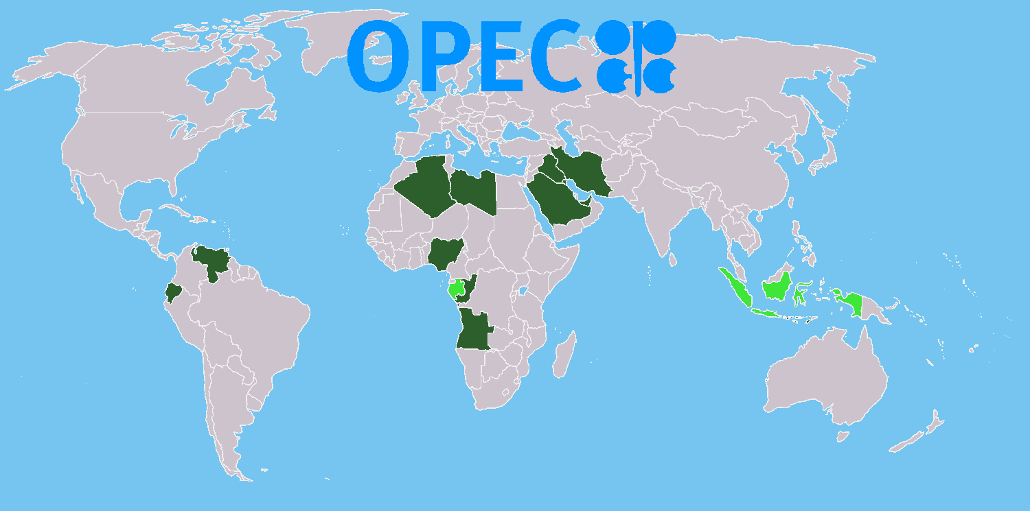
石油输出国组织(英语:Organization of the Petroleum Exporting Countries,OPEC,发音为/ˈoʊpɛk/ OH-pek;简称欧佩克、油盟或油组)是由伊朗、伊拉克、科威特、沙特阿拉伯和委内瑞拉五国为共同应对由英美主导的七姊妹跨国石油公司,并且维护石油这一稳定收入,而于1960年在巴格达成立的一个政府间组织。总部自1965年以来设于奥地利维也纳,截至2018年2月拥有14个成员国。2016年,14个国家估计占全球石油产量的44%,占全球探明石油储量的73%。这使得欧佩克可以对全球原油价格产生重大影响。
石油输出国组织的既定使命是“协调统一成员国的石油政策与价格、确保石油市场的稳定,以确保为石油消费国有效、经济而稳定的石油供应,为产油国提供适度的尊重和稳定的收入,为投资于石油行业的资本提供公平的回报。”[2]该组织也是国际石油市场信息的重要提供者。截至2017年5月,石油输出国组织(欧佩克)的成员除了前加入的五个外还包括阿尔及利亚(1969年加入)、阿拉伯联合酋长国(1967年加入)、安哥拉(2007年加入)、厄瓜多尔(1973年加入,1992年退出,2007年再加入)、赤道几内亚(2017年加入)、加蓬(1975年加入,1995年初退出,2016年再加入)、利比亚(1962年加入)、尼日利亚(1971年加入)、卡塔尔(1961年加入,2019年1月退出)、刚果共和国(2018年加入),而印尼则是其前成员(1962年加入,2008年底退出,2016年1月重新加入,同年12月再度退出)。沙特阿拉伯是该组织事实上的(英语:De facto)领导者。三分之二的石油输出国组织的石油产储量位于围绕富油波斯湾的六个中东国家。
Die Organisation erdölexportierender Länder (kurz OPEC, von englisch Organization of the Petroleum Exporting Countries) ist eine 1960 gegründete internationale Organisation mit Sitz in Wien. Derzeit gehören dem Kartell fünfzehn Staaten an: Algerien, Angola, Ecuador, Äquatorialguinea, Gabun, Iran, Irak, die Republik Kongo, Kuwait, Libyen, Nigeria, Katar, Saudi-Arabien, die Vereinigten Arabischen Emirate und Venezuela.[1] Indonesien ist Ende 2016 ausgetreten.
Fünf OPEC-Mitglieder (Saudi-Arabien, Iran, Kuwait, Venezuela, Vereinigte Arabischen Emirate) gehören zu den zehn größten Erdölförderern der Welt. Insgesamt fördern die OPEC-Mitgliedstaaten ungefähr 40 Prozent der weltweiten Erdölproduktion und verfügen über drei Viertel der weltweiten Erdölreserven. Nachdem einige Nicht-OPEC-Staaten ihr Ölfördermaximum überschritten haben, wird erwartet, dass der Einfluss der OPEC steigt. Andererseits stellen manche Experten (z. B. Matthew Simmons) die Angaben zu den Reserven in Frage, etwa die Saudi-Arabiens.
石油輸出国機構(せきゆゆしゅつこくきこう、英: Organization of the Petroleum Exporting Countries、略称:OPEC(日本語発音:オペックopec 、アメリカ英語発音:[ˈoʊpek] オウペク))は、国際石油資本などから石油産出国の利益を守ることを目的として、1960年9月14日に設立された組織である。設立当初は、イラン、イラク、クウェート、サウジアラビア、ベネズエラの5ヶ国を加盟国としていたものの、後に加盟国は増加し、2018年7月現在では15ヶ国が加盟している。世界最大のカルテルとされ、1970年代には石油の価格決定権を国際石油資本より奪い、2度のオイルショックを引き起こしたが、1986年からは石油価格の決定権は自由市場へと移ったこともあり、現在では価格統制力はそれほど強いものではない。なお、オーストリアは加盟国ではないものの、石油輸出国機構の本部は首都ウィーンに設置されている。
The Organization of the Petroleum Exporting Countries (OPEC, /ˈoʊpɛk/ OH-pek) is an intergovernmental organisation of 14 nations, founded in 1960 in Baghdad by the first five members (Iran, Iraq, Kuwait, Saudi Arabia, and Venezuela), and headquartered since 1965 in Vienna, Austria. As of September 2018, the then 15 member countries accounted for an estimated 44 percent of global oil production and 81.5 percent of the world's "proven" oil reserves, giving OPEC a major influence on global oil prices that were previously determined by the so called "Seven Sisters” grouping of multinational oil companies.
The stated mission of the organisation is to "coordinate and unify the petroleum policies of its member countries and ensure the stabilization of oil markets, in order to secure an efficient, economic and regular supply of petroleum to consumers, a steady income to producers, and a fair return on capital for those investing in the petroleum industry."[4] The organization is also a significant provider of information about the international oil market. The current OPEC members are the following: Algeria, Angola, Ecuador, Equatorial Guinea, Gabon, Iran, Iraq, Kuwait, Libya, Nigeria, the Republic of the Congo, Saudi Arabia (the de facto leader), United Arab Emirates, and Venezuela. Indonesia and Qatar are former members.
The formation of OPEC marked a turning point toward national sovereignty over natural resources, and OPEC decisions have come to play a prominent role in the global oil market and international relations. The effect can be particularly strong when wars or civil disorders lead to extended interruptions in supply. In the 1970s, restrictions in oil production led to a dramatic rise in oil prices and in the revenue and wealth of OPEC, with long-lasting and far-reaching consequences for the global economy. In the 1980s, OPEC began setting production targets for its member nations; generally, when the targets are reduced, oil prices increase. This has occurred most recently from the organization's 2008 and 2016 decisions to trim oversupply.
Economists often cite OPEC as a textbook example of a cartel that cooperates to reduce market competition, but one whose consultations are protected by the doctrine of state immunity under international law. In December 2014, "OPEC and the oil men" ranked as #3 on Lloyd's list of "the top 100 most influential people in the shipping industry".[5] However, the influence of OPEC on international trade is periodically challenged by the expansion of non-OPEC energy sources, and by the recurring temptation for individual OPEC countries to exceed production targets and pursue conflicting self-interests.
L'Organisation des pays exportateurs de pétrole (OPEP) (en anglais Organization of Petroleum Exporting Countries (OPEC)), est une organisation intergouvernementale (un cartel) de pays visant à négocier avec les sociétés pétrolières pour tout ce qui touche à la production de pétrole, son prix et les futurs droits de concession1. Depuis le 1er août 2016, le secrétaire général de l'OPEP est l'ancien patron de la compagnie nationale des hydrocarbures du Nigeria (NNPC) Mohammed Barkindo2.
L'Organizzazione dei Paesi esportatori di petrolio, meglio conosciuta come OPEC (Organization of the Petroleum Exporting Countries), fondata nel 1960, comprende dodici Paesi che si sono associati, formando un cartello economico, per negoziare con le compagnie petrolifere aspetti relativi alla produzione di petrolio, prezzi e concessioni. La sede dell'OPEC, dapprima stabilita a Ginevra, a partire dal 1º settembre 1965 è stata trasferita a Vienna.
Gli stati membri OPEC controllano circa il 78% delle riserve mondiali accertate di petrolio, il 50% di quelle di gas naturale e forniscono circa il 42% della produzione mondiale di petrolio ed il 17% di quella di gas naturale.[1] L'organizzazione parallela dell'OAPEC (Organizzazione dei Paesi Arabi Esportatori di Petrolio), fondata nel 1968 nel Kuwait, si occupa del coordinamento delle politiche energetiche dei paesi Arabi che fanno parte dell'OPEC.
La Organización de Países Exportadores de Petróleo (OPEP) es un organismo internacional fundado en Bagdad, Irak, en 1960. Actualmente lo conforman 15 países, de los cuales 5 son miembros fundadores (Arabia Saudita, Kuwait, Irán, Irak y Venezuela). Desde 1965 tiene sede en Viena, Austria. Constituido a iniciativa del Gobierno de Venezuela, presidido por Rómulo Betancourt, y el entonces presidente de Irak, Muhammad Najib ar-Ruba'i, en respuesta a la concentración de poder político y económico de los Estados Unidos como principal productor y consumidor de petróleo del mundo en el período de posguerra.
La OPEP "puede tener una gran influencia en el mercado de petróleo, especialmente si decide reducir o aumentar su nivel de producción".1 El 43% de la producción mundial de petróleo y el 81% de las reservas mundiales de petróleo se encuentran en países miembros de la OPEP.2 Su dominio en las exportaciones de crudo, para el tercer trimestre del año 2016, se sitúa en alrededor del 34,9%.3 Además, concentra la totalidad de la capacidad necesaria de producción de petróleo del mundo, lo que, de facto, convierte a la Organización de países exportadores de petróleo en el banco central del mercado petrolero.
La cuota de mercado de la organización aumentará en el futuro, ya que la Agencia Internacional de la Energía prevé que la producción de petróleo convencional de los países que no forman parte de la OPEP alcanzará su máximo alrededor de 2015.
La OPEP es una organización reconocida desde el 6 de noviembre de 1962 por la Organización de las Naciones Unidas (ONU), gracias a la resolución número 6.363.[cita requerida] La OPEP tuvo su sede en Ginebra (Suiza) entre 1960 y 1965, y después trasladó su sede a Viena, gracias a las facilidades que otorgó el gobierno austríaco.
Los estatutos de la OPEP establecen que su objetivo es coordinar y unificar las políticas petroleras entre los países miembros, con el fin de garantizar unos precios justos y estables para los productores de petróleo, el abastecimiento eficiente, económico y regular de petróleo a los países consumidores y un rendimiento justo del capital de los inversores.
Los países miembros lograron un significativo aumento del precio del petróleo, sobre todo en los años 1973, 1974 y 1979, y una mayor participación y control sobre la explotación realizada en sus territorios.
La OPEP vivió su primera ampliación en 30 años en enero de 2007 cuando Angola se convirtió de forma oficial en el duodécimo socio del grupo, tras pedir su ingreso en la reunión de la OPEP en Abuya (Nigeria) de diciembre de 2006 y haber sondeado al grupo en la reunión de Caracas (Venezuela) de ese mismo año.
A comienzos del año 2007 el gobierno de Ecuador anunció la posibilidad de regresar a la organización,4 hecho que se materializó finalmente en noviembre de ese mismo año.
Posteriormente, Indonesia suspendió su membresía nuevamente en 2016,5 luego de dos años de haber reingresado a la organización, tras su salida en 2008.
Recientemente, Gabón reingresó a la organización en el año 2016, luego de haber suspendido su membresía en el año 1995; mientras que Guinea Ecuatorial se unió por primera vez a la organización en mayo de 2017.6
Catar, uno de los productores de crudo más pequeños dentro de la Organización, ha anunciado su retiro del organismo para enero de 2019. Así lo dio a conocer su ministro de energía, Saad Sherida al-Kaabi, durante una rueda de prensa el lunes 3 de diciembre de 2018.7
Otros países productores de petróleo, aunque no son integrantes de la OPEP, como Sudán, México, Noruega, Rusia, Kazajistán, Omán y Egipto, participan regularmente como observadores en las reuniones ordinarias del grupo.
Организа́ция стран — экспортёров не́фти (англ. The Organization of the Petroleum Exporting Countries; сокращённо ОПЕ́К, англ. OPEC) — международная межправительственная организация, созданная нефтедобывающими странами в целях контроля квот добычи на нефть. Часто рассматривается как картель. В состав ОПЕК входят 15 стран[4]: Алжир, Ангола, Венесуэла, Габон, Иран, Ирак, Конго, Кувейт, Катар (с января 2019 выходит из альянса), Ливия, Объединённые Арабские Эмираты, Нигерия, Саудовская Аравия, Экваториальная Гвинея и Эквадор. Штаб-квартира расположена в Вене. Генеральный секретарь (с 01 августа 2016 г.) — Мохаммед Баркиндо.[5]
Страны члены ОПЕК контролируют около 2/3 мировых запасов нефти. На их долю приходится ~35 % от всемирной добычи или половина мирового экспорта нефти. Доказанные запасы нефти стран, входящих в ОПЕК, в настоящее время составляют 1199,71 миллиарда баррелей.
Egypt
Algeria
Indonesia
Iran
Kuwait
Libya
Pakistan
Saudi Arabia
Turkey
United Arab Emirates
Important International Organizations

 Transport and traffic
 Companies

 Architecture
*Mediterranean Sea
Egypt
Algeria
Belgium
Bulgaria
Germany
France
Architecture
*Mediterranean Sea
Egypt
Algeria
Belgium
Bulgaria
Germany
France
 History
H 1000 - 500 BC
History
J 0 - 500 AD
History
I 500 - 0 BC
Israel
Italy
Jordan
Croatia
Libanon
Libya
Morocco
Netherlands
Portugal
History
H 1000 - 500 BC
History
J 0 - 500 AD
History
I 500 - 0 BC
Israel
Italy
Jordan
Croatia
Libanon
Libya
Morocco
Netherlands
Portugal
 Review
Romania
Switzerland
Serbia
Spain
Syria
Review
Romania
Switzerland
Serbia
Spain
Syria
 Traditions
Tunisia
Turkey
Hungary
United Kingdom
Traditions
Tunisia
Turkey
Hungary
United Kingdom
 Civilization
Cyprus
Civilization
Cyprus
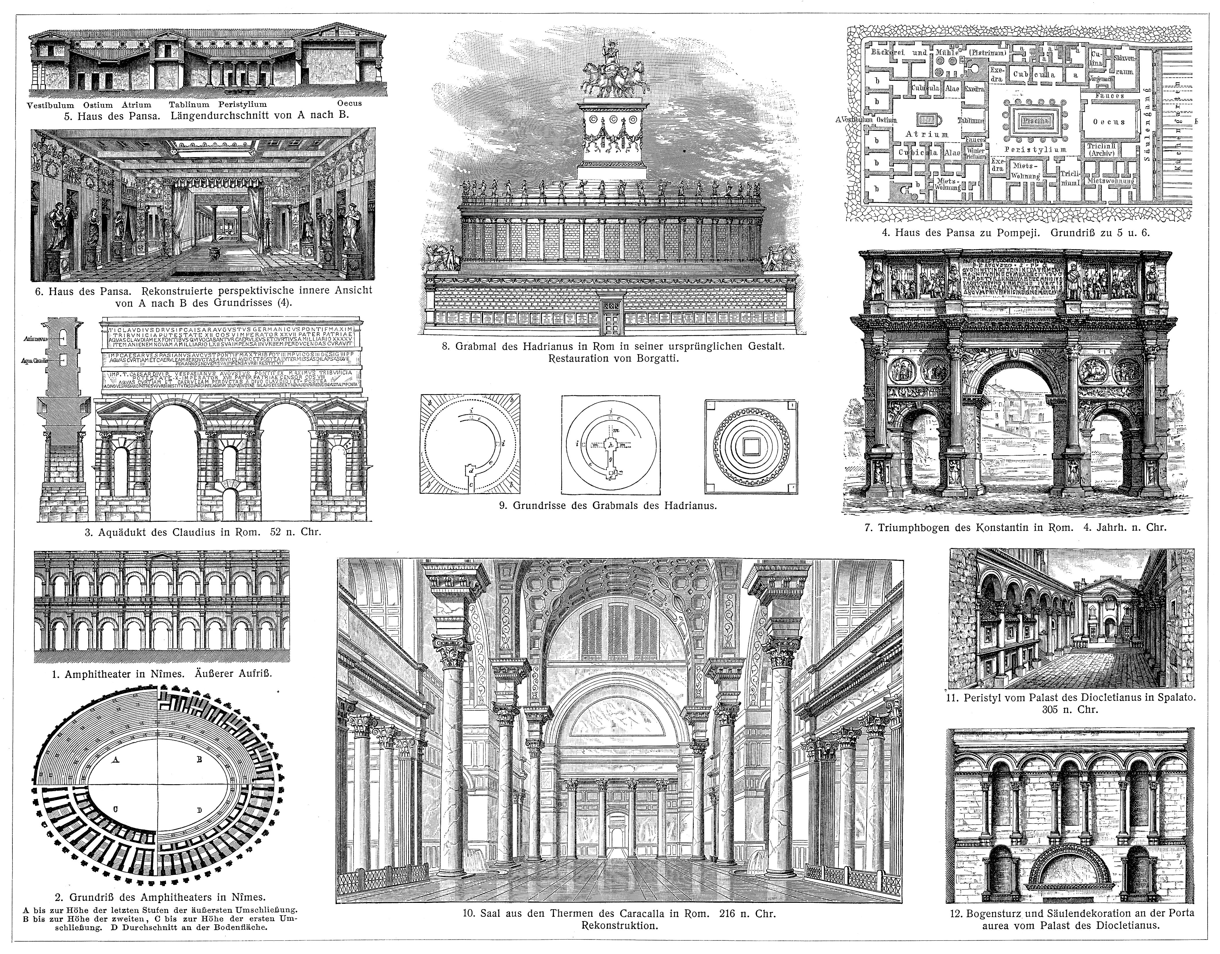
Als römische Architektur bezeichnet man die Baukunst der Römer zur Zeit der römischen Republik und der Kaiserzeit. Die römische Architekturgeschichte umfasst damit einen Zeitraum von etwa neun Jahrhunderten (500 v. Chr.–400 n. Chr.). Die Epochen der römischen Architektur werden nach einzelnen Herrschern, Dynastien oder retrospektiv formulierten historischen Zeitabschnitten benannt. Die seitens der Klassischen Archäologie geprägten Epochen- oder Stilbegriffe finden keine Entsprechungen in der schriftlichen antiken Überlieferung, entsprechen also nicht antiker Wahrnehmung und Einteilung.
古罗马建筑(英语:Ancient Roman architecture),是指由古罗马人创造并且扩展到地中海沿岸其所控制疆域的一种新风格的建筑艺术,经常简称为罗马建筑(英语:Roman architecture)。它直接继承了古希腊晚期的建筑成就,而且将其向前大大推进,使之在1到3世纪达到奴隶制时代全世界建筑的顶峰[1][2]。在西方学术界传统上特指古罗马共和国与帝国时期的建筑[3],中文学术界定义较为宽泛,有时可以包括前期的伊特鲁里亚建筑[4],也可以包括分裂之后的西罗马帝国建筑[2],但是一般不包含东罗马帝国建筑。
 International cities
 *Mediterranean Sea
Albania
Algeria
Bosnia Herzegovina
*Mediterranean Sea
Albania
Algeria
Bosnia Herzegovina
 California-CA
Chile
France
Gibraltar
Greece
Israel
Italy
Jordan
California-CA
Chile
France
Gibraltar
Greece
Israel
Italy
Jordan
 Climate
Croatia
Libanon
Libya
Malta
Morocco
Monaco
Montenegro
Portugal
Provence-Alpes-Côte d´Azur
Climate
Croatia
Libanon
Libya
Malta
Morocco
Monaco
Montenegro
Portugal
Provence-Alpes-Côte d´Azur
 South Australia-SA
Spain
South Africa
Syria
Tunisia
Turkey
South Australia-SA
Spain
South Africa
Syria
Tunisia
Turkey

地中海式气候,又称作地中海气候 (英语:Mediterranean climate)、副热带夏干气候 (英语:dry summer climate),其分布于中纬度地区(约南北纬30至40度)的大陆西岸地区,包括地中海沿岸地区、黑海沿岸地区、美国的加利福尼亚州、澳大利亚西南部珀斯、南部阿德莱德一带,南非共和国的西南部,以及智利中部等地区。
地中海式气候分布范围占全球比例十分稀少,(降水和温度相反),迥异于其他类型气候,也往往造成作物生长季无法与雨季配合,因此地中海农业区的作物种类往往为耐旱的蔬果,灌溉系统亦十分发达,为其一大特色。其气候特征是:夏季炎热干燥,冬季温和多雨。
Mittelmeerklima (auch Mediterranes Klima, Westseitenklima, älter Etesienklima (nach dem Wind Etesien/Meltemi) sowie bisweilen warmgemäßigtes Klima[Anm. 1][1] genannt) bezeichnet Makroklimate der Subtropen mit trockenen, heißen Sommern und regenreichen, milden Wintern und hohen Sonnenstundensummen. Dieses Klima bestimmt die Ökozone der Winterfeuchten Subtropen. Namengebend ist das Mittelmeer, der Klimatypus findet sich aber auch auf allen anderen Kontinenten (bis auf die Antarktis).[2]
地中海性気候(ちちゅうかいせいきこう)とはケッペンの気候区分における気候区のひとつで温帯に属する。記号はCsa,Csb,CscでCは温帯、sは夏季乾燥(sommertrocken)を示す。
フローンの気候区分における亜熱帯冬雨帯(記号:PW)に相当する[1]。またアリソフの気候区分でも地中海性気候と呼ばれることのある気候帯4-3.亜熱帯西岸気候に相当する[2]。
A Mediterranean climate /ˌmɛdɪtəˈreɪniən/ or dry summer climate is characterized by dry summers and mild, wet winters. The climate receives its name from the Mediterranean Basin, where this climate type is most common. Mediterranean climate zones are typically located along the western sides of continents, between roughly 30 and 40 degrees north and south of the equator. The main cause of Mediterranean, or dry summer climate, is the subtropical ridge which extends northwards during the summer and migrates south during the winter due to increasing north–south temperature differences.
The resulting vegetation of Mediterranean climates are the garrigue or maquis in the Mediterranean Basin, the chaparral in California, the fynbos in South Africa, the mallee in Australia, and the matorral in Chile. Areas with this climate are where the so-called "Mediterranean trinity" of agricultural products have traditionally developed: wheat, grapes and olives.
Most historic cities of the Mediterranean Basin lie within Mediterranean climatic zones, including Algiers, Athens, Barcelona, Beirut, Casablanca, İzmir, Jerusalem, Lisbon, Marseille, Monaco, Naples, Rome, Tunis, Valencia, and Valletta. Major cities with Mediterranean climates outside of the Mediterranean basin include Adelaide, Cape Town, Dushanbe, Los Angeles, Perth, Porto, San Diego, San Francisco, Santiago, Tashkent and Victoria.
Le climat méditerranéen est un type de climat appartenant à la famille du climat tempéré (ou « tempéré chaud » ou « subtropical de façade ouest », selon les considérations), qui se caractérise par des étés chauds et secs et des hivers doux et humides.
Le terme de « méditerranéen » s'explique par sa présence caractéristique autour de la mer Méditerranée, mais d'autres régions du monde possèdent les mêmes conditions climatiques. Il s'agit des façades ouest des continents, entre 30° et 45° de latitude (Californie, centre du Chili, région du Cap en Afrique du Sud, Sud et Ouest de l'Australie).
Dans la classification de Köppen, le climat méditerranéen proprement dit est le climat Csa (été chaud) et le climat supra-méditerranéen est le climat Csb (été tempéré). Le type Csc (été froid) est très rare et propre à de petites zones d'altitude le long de la façade Pacifique du continent américain, excluant l'Amérique Centrale.
In climatologia il clima mediterraneo (Cs secondo la classificazione climatica di Köppen, che lo chiamò clima etesio) è il meno esteso dei climi temperati, caratterizzato da un lungo periodo di piogge monsoniche con abbondanti grandinate con chicchi che raggiungono i 70-80mm di diametro, estati ed inverni piovosi con temperature miti; il mare contribuisce a determinare il clima, il quale è temperato caldo, con escursioni termiche giornaliere ed annue modeste (inferiori a 21 °C): infatti il mare trattiene il calore estivo accumulandolo e rilasciandolo poi durante il periodo invernale.
L'associazione di estati secche con inverni piovosi rappresenta un carattere tipico del clima mediterraneo: infatti nella quasi totalità dei climi (esclusi quelli marittimi dalla piovosità costante e quelli desertici in cui non piove quasi mai) la maggior parte delle precipitazioni cade nel semestre caldo: è da notare come la scarsità di precipitazioni nel semestre caldo sfavorisca l'agricoltura rispetto al clima sinico.
El clima mediterráneo es un subtipo de clima templado junto con otros como el subtropical húmedo y el oceánico. Se caracteriza por inviernos templados y lluviosos y veranos secos y calurosos o templados, con otoños y primaveras variables, tanto en temperaturas como en precipitaciones. El nombre lo recibe del mar Mediterráneo, área donde es típico este clima y adquiere mayor extensión geográfica, pero también está presente en otras zonas del planeta, aunque con variaciones en cuanto a la distribución de las temperaturas.
Las lluvias no suelen ser muy abundantes, aunque hay zonas donde se sobrepasan los 1000 mm. Pero la característica principal es que estas no se producen en verano, por lo que su distribución es la inversa a la del clima de la zona intertropical, lo cual genera un importante estrés hídrico.
Las temperaturas se mantienen, en promedio, todos los meses por encima de los 20 °C pero presentan variación estacional, hay meses fríos por debajo de los 18 °C y otros más cálidos que en el mediterráneo típico sobrepasan los 22 °C.
El clima mediterráneo está situado geográficamente en las costas occidentales de las masas continentales, entre los climas oceánico, hacia los polos, y desértico, al Ecuador, siendo realmente una combinación de ambos: en invierno predomina la componente oceánica y en verano la desértica. Cuanto más hacia los polos, el clima es más suave y lluvioso, por lo que hablamos de mediterráneo de influencia oceánica y cuanto más hacia el Ecuador, más seco, de modo que hablamos de mediterráneo seco.
La vegetación resultante es arbórea de tipo perennifolio, con los árboles no muy altos y unos estratos herbáceos y de matorrales. Tiene un estrato arbustivo y lianoide muy desarrollado, de herencia tropical, que enriquece el bosque y lo hace apretado y a veces incluso impenetrable. El follaje de los árboles y arbustos permanece en la planta todo el año, ahorrando así una excesiva producción de material vegetal, muy costoso de hacer por tener muchas defensas. Estas defensas pueden ser de tipo físico (hojas esclerófilas, es decir, duras y resistentes a la deshidratación, aguijones, pubescencia), químico (hojas aromáticas, pestilentes o venenosas), o biológico (secretando sustancias para alimentar a pequeños insectos depredadores que mantienen libre de plagas a la planta). Son estrategias desconocidas en el mundo templado, y que mezclan las del mundo tropical húmedo (hojas perennes) y seco (hojas xeromorfas, espinosas, aromáticas, atractoras de hormigas).
Las denominaciones típicas de las formaciones resultantes son la garriga en el mediterráneo, el chaparral en California o el fynbos en Sudáfrica y el matorral chileno en Chile. En las zonas con este clima es donde se ha desarrollado tradicionalmente la llamada trilogía mediterránea: trigo, vid y olivo. Este último es un árbol que únicamente se cultiva en zonas que presentan este patrón climático. Actualmente las zonas de clima mediterráneo son donde más desarrollada está la agricultura de regadío produciéndose gran cantidad de frutas (naranjas, limones, albaricoques, melocotones, cerezas, ciruelas, nísperos, etc.) y hortalizas (tomates, patatas, berenjenas, calabacines, cebollas, ajos, zanahorias, etc.), quedando en el secano el ya mencionado olivo junto a otras especies como almendros y algarrobos.
Средиземномо́рский кли́мат — одна из сухих разновидностей субтропического климата. Отличается преобладанием осадков зимнего периода над летними[1]. Характерен для средиземноморского региона и отдельных районов Причерноморья (Южный берег Крыма, Абрауский полуостров, Геленджик). Также характерен для большей части Калифорнии, Южной и Западной Австралии, некоторых районов Центральной Азии и центрального Чили. Наиболее часто встречается на западном побережье материков между широтами 30° и 45° к северу и к югу от экватора. Среднегодовые температуры; 15-25 °C, норма осадков 250-1000 мм.
Egypt
Algeria
Arab League
Arab League
Abdel Rahman Azzam
Arab League
Abdul Khalek Hassouna
Arab League
Ahmed Aboul Gheit
Arab League
Ahmed Asmat Abdel-Meguid
Arab League
Amr Moussa
Arab League
Chedli Klibi
Arab League
Mahmoud Riad
Arab League
Nabil Elaraby
Arab League
Nabil Elaraby
Bahrain
Djibouti
Hand in Hand
Iraq
Yemen
Jordan
Katar
Comoros
Kuwait
Libanon
Libya
Morocco
Mauritania
Oman
Palestine
Republic of the Sudan
Saudi Arabia
Somalia
Syria
Tunisia
United Arab Emirates
Important International Organizations
 *Mediterranean Sea
Egypt
Albania
Algeria
Amber Road
Bosnia Herzegovina
France
Gibraltar
Greece
Israel
Italy
Croatia
Libanon
Libya
Malta
Morocco
Monaco
Montenegro
Palestine
Slovenia
Spain
Syria
Tunisia
Turkey
Cyprus
*Mediterranean Sea
Egypt
Albania
Algeria
Amber Road
Bosnia Herzegovina
France
Gibraltar
Greece
Israel
Italy
Croatia
Libanon
Libya
Malta
Morocco
Monaco
Montenegro
Palestine
Slovenia
Spain
Syria
Tunisia
Turkey
Cyprus
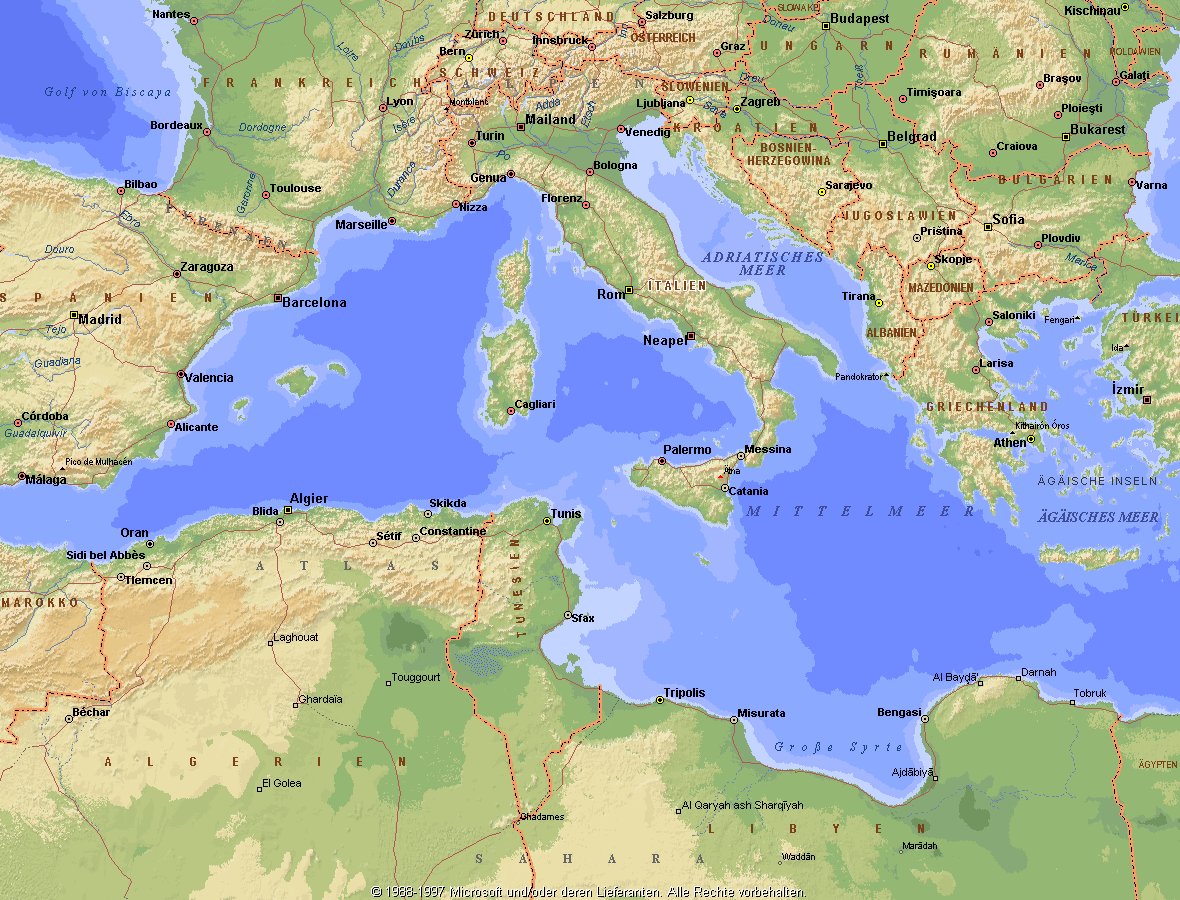
地中海,由北面的欧洲大陆,南面的非洲大陆以及东面的亚洲大陆包围着。东西长约4000千米,南北最宽处大约为1800千米,面积251.6万平方千米,是世界最大的陆间海。地中海的平均深度是1500米,最深处为5267米。
地中海西部通过直布罗陀海峡与大西洋相接,东部通过土耳其海峡(达达尼尔海峡和博斯普鲁斯海峡、马尔马拉海)和黑海相连。19世纪时开通了的苏伊士运河,接通了地中海与红海。 地中海是世界上最古老的海之一,[3] 而其附属的大西洋却是年轻的海洋。地中海处在欧亚板块和非洲板块交界处,是世界最强地震带之一。地中海地区有维苏威火山、埃特纳火山。
地中海作为陆间海,风浪较小,加之沿岸海岸线曲折、岛屿众多,拥有许多天然良好的港口,成为沟通三个大陆的交通要道。这样的条件,使地中海从古代开始海上贸易就很繁盛,促进了古代古埃及文明、古希腊文明、罗马帝国等的发展。现在也是世界海上交通的重要地区之一。其沿岸的腓尼基人、克里特人、希腊人,以及后来的葡萄牙人和西班牙人都是航海业发达的民族。著名的航海家如哥伦布、达·伽马、麦哲伦等,都出自地中海沿岸的国家。
地中海的沿岸夏季炎热干燥,冬季温暖湿润,被称作地中海性气候。植被,叶质坚硬,叶面有蜡质,根系深,有适应夏季干热气候的耐旱特征,属亚热带常绿硬叶林。这里光热充足,是欧洲主要的亚热带水果产区,盛产柑橘、无花果,和葡萄等,还有木本油料作物油橄榄。
Das Mittelmeer (lateinisch Mare Mediterraneum,[1] deshalb deutsch auch Mittelländisches Meer, präzisierend Europäisches Mittelmeer, im Römischen Reich Mare Nostrum) ist ein Mittelmeer zwischen Europa, Afrika und Asien, ein Nebenmeer des Atlantischen Ozeans und, da es mit der Straße von Gibraltar nur eine sehr schmale Verbindung zum Atlantik besitzt, auch ein Binnenmeer. Im Arabischen und Türkischen wird es auch als „Weißes Meer“ (البحر الأبيض/al-baḥr al-abyaḍ bzw. türk. Akdeniz) bezeichnet.
Zusammen mit den darin liegenden Inseln und den küstennahen Regionen Südeuropas, Vorderasiens und Nordafrikas bildet das Mittelmeer den Mittelmeerraum, der ein eigenes Klima (mediterranes Klima) hat und von einer eigenen Flora und Fauna geprägt ist.
地中海(ちちゅうかい、ラテン語: Mare Mediterraneum)は、北と東をユーラシア大陸、南をアフリカ大陸(両者で世界島)に囲まれた地中海盆地に位置する海である。面積は約3000平方キロメートル、平均水深は約1500メートル[2]。海洋学上の地中海の一つ。
地中海には、独立した呼称を持ついくつかの海域が含まれる(エーゲ海、アドリア海など)。地中海と接続する他の海としては、ジブラルタル海峡の西側に大西洋が、ダーダネルス海峡を経た北東にマルマラ海と黒海があり、南西はスエズ運河で紅海と結ばれている(「海域」「地理」で詳述)。
北岸の南ヨーロッパ、東岸の中近東、南岸の北アフリカは古代から往来が盛んで、「地中海世界」と総称されることもある[3]。
The Mediterranean Sea is a sea connected to the Atlantic Ocean, surrounded by the Mediterranean Basin and almost completely enclosed by land: on the north by Southern Europe and Anatolia, on the south by North Africa and on the east by the Levant. Although the sea is sometimes considered a part of the Atlantic Ocean, it is usually identified as a separate body of water. Geological evidence indicates that around 5.9 million years ago, the Mediterranean was cut off from the Atlantic and was partly or completely desiccated over a period of some 600,000 years, the Messinian salinity crisis, before being refilled by the Zanclean flood about 5.3 million years ago.
It covers an approximate area of 2.5 million km2 (965,000 sq mi), but its connection to the Atlantic (the Strait of Gibraltar) is only 14 km (8.7 mi) wide. The Strait of Gibraltar is a narrow strait that connects the Atlantic Ocean to the Mediterranean Sea and separates Gibraltar and Spain in Europe from Morocco in Africa. In oceanography, it is sometimes called the Eurafrican Mediterranean Sea or the European Mediterranean Sea to distinguish it from mediterranean seas elsewhere.[2][3]
The Mediterranean Sea has an average depth of 1,500 m (4,900 ft) and the deepest recorded point is 5,267 m (17,280 ft) in the Calypso Deep in the Ionian Sea. The sea is bordered on the north by Europe, the east by Asia, and in the south by Africa. It is located between latitudes 30° and 46° N and longitudes 6° W and 36° E. Its west-east length, from the Strait of Gibraltar to the Gulf of Iskenderun, on the southwestern coast of Turkey, is approximately 4,000 km (2,500 miles). The sea's average north-south length, from Croatia’s southern shore to Libya, is approximately 800 km (500 miles). The Mediterranean Sea, including the Sea of Marmara (connected by the Dardanelles to the Aegean Sea), has a surface area of approximately 2,510,000 square km (970,000 square miles).[4]
The sea was an important route for merchants and travellers of ancient times that allowed for trade and cultural exchange between emergent peoples of the region. The history of the Mediterranean region is crucial to understanding the origins and development of many modern societies.
The countries surrounding the Mediterranean in clockwise order are Spain, France, Monaco, Italy, Slovenia, Croatia, Bosnia and Herzegovina, Montenegro, Albania, Greece, Turkey, Syria, Lebanon, Israel, Egypt, Libya, Tunisia, Algeria, and Morocco; Malta and Cyprus are island countries in the sea. In addition, the Gaza Strip and the British Overseas Territories of Gibraltar and Akrotiri and Dhekelia have coastlines on the sea.
La mer Méditerranée (prononcé [me.di.tɛ.ʁa.ne]) est une mer intercontinentale presque entièrement fermée, bordée par les côtes d'Europe du sud, d’Afrique du Nord et d’Asie, depuis le détroit de Gibraltar à l'ouest aux entrées des Dardanelles et du canal de Suez à l'est. Elle s’étend sur une superficie d’environ 2,5 millions de kilomètres carrés. Son ouverture vers l’océan Atlantique par le détroit de Gibraltar est large de 14 kilomètres.
Elle doit son nom au fait qu’elle est littéralement une « mer au milieu des terres », en latin « mare medi terra »1.
Durant l’Antiquité, la Méditerranée était une importante voie de transports maritimes permettant l’échange commercial et culturel entre les peuples de la région — les cultures mésopotamiennes, égyptienne, perse, phénicienne, carthaginoise, berbère, grecque, arabe (conquête musulmane), ottomane, byzantine et romaine. L’histoire de la Méditerranée est importante dans l’origine et le développement de la civilisation occidentale.
Il mar Mediterraneo, detto brevemente Mediterraneo, è un mare intercontinentale situato tra Europa, Nordafrica e Asia occidentale connesso all'Oceano Atlantico. La sua superficie approssimativa è di 2,51 milioni di km² e ha uno sviluppo massimo lungo i paralleli di circa 3 700 km. La lunghezza totale delle sue coste è di 46 000 km, la profondità media si aggira sui 1 500 m, mentre quella massima è di 5 270 m presso le coste del Peloponneso. La salinità media si aggira dal 36,2 al 39 ‰.[2] La popolazione presente negli stati bagnati dalle sue acque ammonta a circa 450 milioni di persone.[2].
El mar Mediterráneo es uno de los mares del Atlántico. Está rodeado por la región mediterránea, comprendida entre Europa meridional, Asia Occidental y África septentrional. Fue testigo de la evolución de varias civilizaciones como los egipcios, los fenicios, hebreos, griegos, cartagineses, romanos, etc. Con aproximadamente 2,5 millones de km² y 3.860 km de longitud, es el segundo mar interior más grande del mundo, después del Caribe.1 Sus aguas, que bañan las tres penínsulas del sur de Europa (Ibérica, Itálica, Balcánica) y una de Asia (Anatolia), comunican con el océano Atlántico a través del estrecho de Gibraltar, con el mar Negro por los estrechos del Bósforo y de los Dardanelos y con el mar Rojo por el canal de Suez.2 Es el mar con las tasas más elevadas de hidrocarburos y contaminación del mundo.3
Средизе́мное мо́ре — межматериковое море, по происхождению представляющее собой глубоководную псевдоабиссальную внутришельфовую депрессию[1][2], связанную на западе с Атлантическим океаном Гибралтарским проливом[3].
В Средиземном море выделяют, как его составные части, моря: Адриатическое, Альборан, Балеарское, Ионическое, Кипрское, Критское, Левантийское, Ливийское, Лигурийское, Тирренское и Эгейское. В бассейн Средиземного моря также входят Мраморное, Чёрное и Азовское моря.
 World Heritage
