
漢德百科全書 | 汉德百科全书
 Silk road
Belgium
 History
 International cities
 *European Capital of Culture
Olympic Summer Games
Silk road
*European Capital of Culture
Olympic Summer Games
Silk road
 Important port
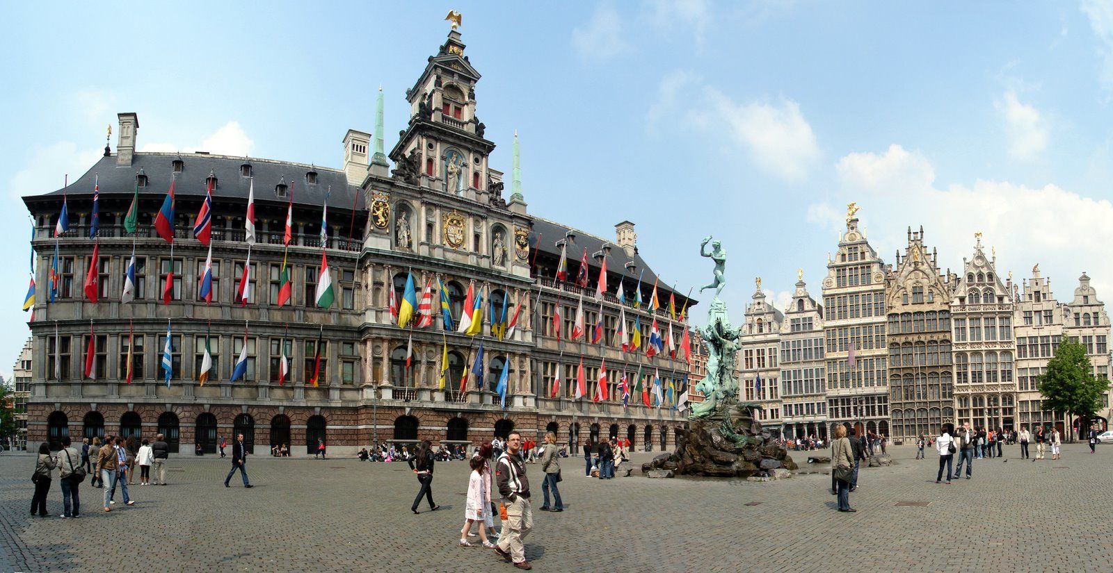
Antwerpen (veraltet deutsch Antorf oder Antorff, französisch Anvers) ist eine Hafenstadt in der Region Flandern in Belgien und die Hauptstadt der Provinz Antwerpen. Bezogen auf die Stadt als Verwaltungseinheit ist Antwerpen die größte Stadt des Landes. Die Agglomeration Antwerpen ist nach der Region Brüssel-Hauptstadt die zweitgrößte in Belgien.
Von großer internationaler Bedeutung ist Antwerpen durch seinen Seehafen, den zweitgrößten Europas, sowie als weltweit wichtigstes Zentrum für die Verarbeitung und den Handel von Diamanten.
Antwerpen war im 15. und 16. Jahrhundert eine der größten Städte der Welt, zeitweise die wichtigste Handelsmetropole Europas und als bedeutendes kulturelles Zentrum Wirkungsstätte von Künstlern wie Rubens. Antwerpen war Austragungsort der Olympischen Sommerspiele 1920 und Kulturhauptstadt Europas 1993. Das Druckereimuseum Plantin-Moretus, das Maison Guiette und der Turm der Liebfrauenkathedrale gehören zum UNESCO-Welterbe.
安特卫普位于比利时西北部斯海尔德河畔,是比利时最大港口和重要工业城市,面积140平方公里,人口45.7万人(2005年1月),居民大多使用荷兰地方方言,工商界主要使用法语。安特卫普是欧洲著名文化中心,是著名艺术大师罗宾斯和冯·狄克的诞生地,也是世界著名的游览城市。人们被其吸引的是它的三大看点:一是保存完好、充满中世纪情调的旧市区古老建筑;二是神秘的钻石加工和交易;三是有世界声誉的绘画艺术和众多的博物馆,建有罗宾斯故居博物馆、皇家艺术博物馆、国家海运博物馆以及钻石博物馆等。(Quelle:http://baike.baidu.com)
アントウェルペン(オランダ語: Antwerpen [ˈɑntʋɛrpə(n)] (![]() 音声ファイル), フランス語: Anvers [ɑ̃vɛʁ(s)], 英語: Antwerp [ˈæntwɜrp])は、ベルギーのフランデレン地域・アントウェルペン州の州都で、同国最大の都市(首都圏地域の人口を合わせればブリュッセル市が最大)。英語名に由来するアントワープや、フランス語名に由来するアンヴェルス(アンベルス)[1]も日本語の表記においてよく用いられる。2012年1月1日の総人口は502,604人。面積は204.51 km2, 人口密度は2,457.56人/km2である。
音声ファイル), フランス語: Anvers [ɑ̃vɛʁ(s)], 英語: Antwerp [ˈæntwɜrp])は、ベルギーのフランデレン地域・アントウェルペン州の州都で、同国最大の都市(首都圏地域の人口を合わせればブリュッセル市が最大)。英語名に由来するアントワープや、フランス語名に由来するアンヴェルス(アンベルス)[1]も日本語の表記においてよく用いられる。2012年1月1日の総人口は502,604人。面積は204.51 km2, 人口密度は2,457.56人/km2である。
Antwerp (/ˈæntwɜːrp/ ( listen), Dutch: Antwerpen [ˈɑntʋɛrpə(n)] ( listen), French: Anvers [ɑ̃vɛʁ(s)]) is a city in Belgium, and is the capital of Antwerp province in Flanders. With a population of 520,504,[2] it is the most populous city proper in Belgium. Its metropolitan area houses around 1,200,000 people, coming in second behind Brussels.[3][4]
Antwerp is on the River Scheldt, linked to the North Sea by the Westerschelde estuary. It is about 40 kilometres (25 mi) north of Brussels, and about 15 kilometres (9 mi) from the Dutch border. The Port of Antwerp is one of the biggest in the world, ranking second in Europe[5][6] and within the top 20 globally.[7] Antwerp was also the place of the world's oldest stock exchange building, originally built in 1531 and re-built in 1872.[8]
Antwerp has long been an important city in the Low Countries, both economically and culturally, especially before the Spanish Fury (1576) in the Dutch Revolt. The inhabitants of Antwerp are nicknamed Sinjoren ([sɪnˈjoːˌrən]), after the Spanish honorific señor or French seigneur, "lord", referring to the Spanish noblemen who ruled the city in the 17th century.[9] Today Antwerp is a major trade and cultural centre. The city hosted the 1920 Summer Olympics.
Anvers (prononcé /ɑ̃.vɛʁs/1,2, ou /ɑ̃.vɛʁ/3, en néerlandais : Antwerpen) est une ville belge dans la Région flamande, chef-lieu de la province d'Anvers et de l'arrondissement administratif du même nom, située au cœur de la Dorsale européenne.
Au 1er avril 2017, la commune d’Anvers était la plus peuplée de Belgique, devant Gand et Charleroi, avec 521 216 habitants4, 259 740 hommes et 261 476 femmes, soit une densité de 1 270,06 habitants/km2. L’agglomération anversoise compte, elle, 1 250 000 habitants. C'est la deuxième plus peuplée de Belgique, après Bruxelles. C'est également la troisième commune et ville de Belgique pour ce qui est de la superficie, avec 204,51 km2, juste après Tournai et Couvin.
Archétype de la ville bourgeoise-marchande depuis le Bas Moyen Âge elle constitue alors, selon Fernand Braudel, le centre du commerce international et de la haute finance tout au long du XVIe siècle. Anvers abrite depuis 1931 le plus vieux et unique gratte-ciel d'Europe jusqu'en 1949, la Boerentoren, et dispute à Venise l'invention de la comptabilité en partie double. Anvers est connue pour abriter les plus prestigieux diamantaires de la Planète, avec Londres et Amsterdam, ainsi que la plus importante bourse de diamants de la Planète, la Antwerpse Diamantkring. Elle abrite également une grande concentration d'établissements d'audit et consulting. Enfin, le Port d'Anvers (deuxième port commercial d'Europe en termes d'activités et de tonnage, après celui voisin de Rotterdam) joue un rôle majeur dans la mondialisation des activités économiques européennes.
Les codes postaux vont de 2000 à 2600 à l’intérieur du district de la ville d’Anvers, située principalement sur la rive droite de l’Escaut et connue pour son port international de marchandises extrêmement développé, aujourd'hui le deuxième plus grand d'Europe en termes de volume de marchandises.
Les Anversois sont aussi appelés les Sinjoren, de l’espagnol señor, héritage de l'époque où elle faisait partie de l'Empire habsbourgeois de Charles Quint. La ville est souvent appelée ’t Stad (« La Ville ») et parfois de koekenstad (« la Ville des biscuits ») par allusion aux koffiekoeken (biscuits recouverts d'un fin glaçage au café) d’Anvers, réputées dans toute la Belgique.
Anversa (Antwerpen in olandese, Anvers in francese) è una città di 506.922 abitanti del Belgio settentrionale, la più importante nella regione delle Fiandre, una delle tre regioni dello Stato, e il capoluogo della provincia omonima.
Amberes (en neerlandés, Antwerpen [ˈɑntˌʋɛrpə(n)] (?·i), en francés, Anvers [ɑ̃ˈvɛʁ(s)]), antiguamente conocida como Antuerpia, es una ciudad situada en Bélgica que posee 521.600 habitantes en 2018. El área metropolitana cubre 1.449 km² (559 millas cuadradas) con un total de 2.190.769 habitantes, según el censo del 1 de enero de 2017.
Антве́рпен (нидерл. Antwerpen (инф.) [ˈɑntˌʋɛrpə(n)], фр. Anvers [ɑ̃vɛʁs], з.-флам. Antwerpn) — город во Фламандском регионе Бельгии. Второй (после Брюсселя) город страны, самый большой город Фландрии. Административный центр провинции Антверпен. Город расположен на обоих берегах реки Шельды. Морской порт, входит в двадцатку крупнейших портов мира и является вторым в Европе после порта города Роттердама в Нидерландах[2].

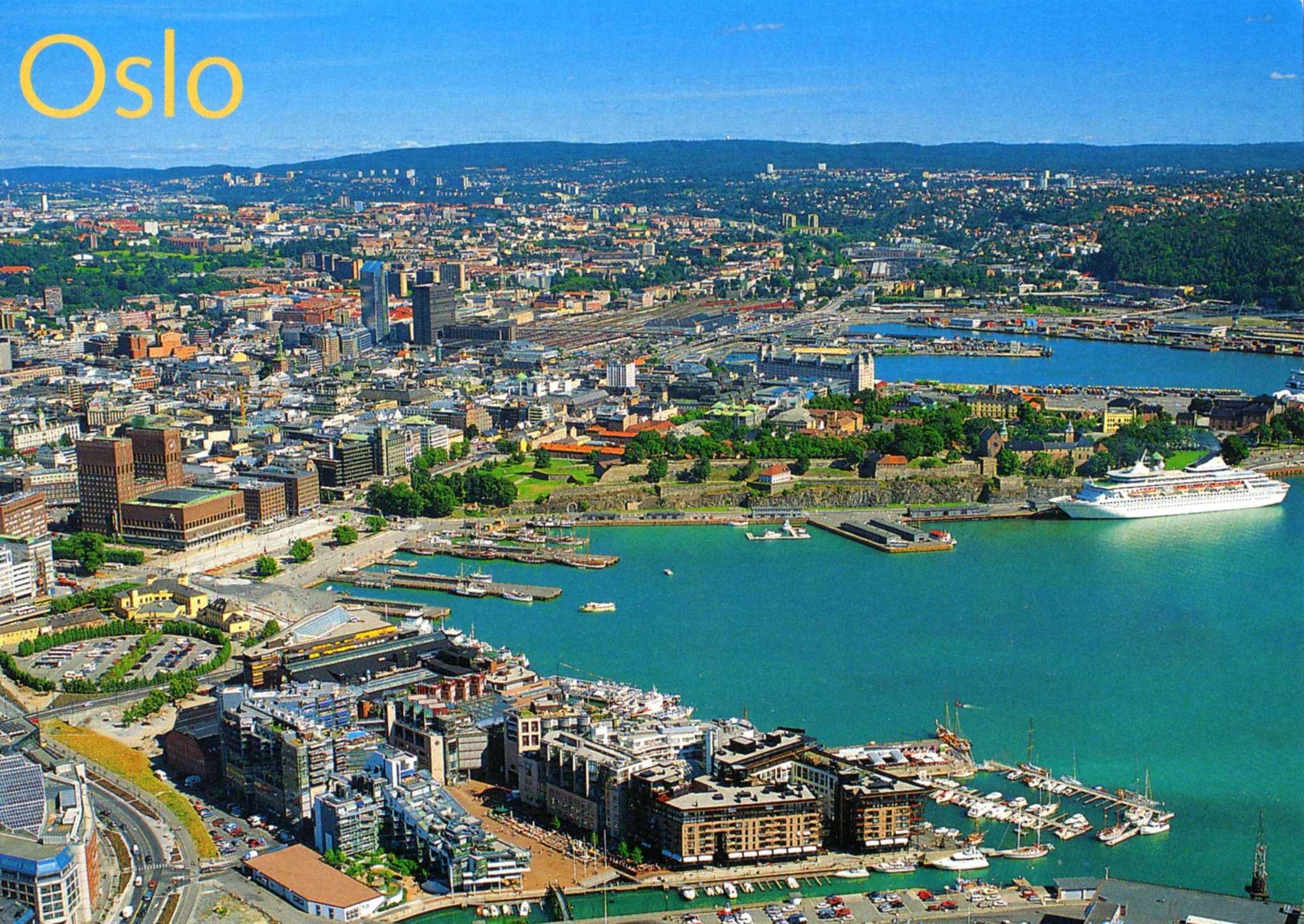
奥斯陆是挪威的首都,人口约85万,位于奥斯陆峡湾的最深处。奥斯陆南临奥斯陆湾,三面被群山环绕,整个城市与绿色的大自然和谐地融为一体。
从奥斯陆中央车站到王宫,再从卡尔约翰大街到国会议事堂周边为步行者天国。大街两侧是摩登的咖啡屋、餐馆和商店。每到夏季或周末这里可看到演艺人的各种演出。周围还有奥斯陆大教堂和国家美术馆。
奥 斯陆还是油画、雕刻、戏剧之都,充满了艺术气息。国家美术馆展出有蒙克的《呐喊》和《玛丽亚》。维格朗雕塑公园绿荫环绕,有200件雕塑艺术品,是人们休 闲娱乐的理想去处。奥斯陆的观光区域大致分为5个区域,卡尔约翰大街周边、阿肯修弗斯城堡周边、王宫周边、布里格周边以及维格朗公园周边等。
奥斯陆卡
还将享受汽车租赁、雪橇租赁以及其他部分设施,如餐厅和商店的折扣。
奥斯陆卡在游客信息中心、大酒店、奥斯陆中央车站售票处、报亭以及通过互联网都可以购买。有效期从第一次使用时的时间开始计算,请再开始使用前做好计划。(Quelle:http://www.visitscandinavia.org/)
奥斯陆(挪威语:Oslo ![]() 聆听 帮助·信息),1925年前旧称克里斯蒂安尼亚(Kristiania),是挪威首都和最大城市,全国政治、经济、文化中心,也是挪威的贸易、银行业、工业和航运枢纽,位于挪威东南部的奥斯陆峡湾内侧,人口666, 759人(截至2017年1月1日)。[8]包括邻近的10个自治市在内的城市区人口为975, 744人(截至2016年1月1日),[9]而整个大奥斯陆地区人口数为1, 546, 706。[8]
聆听 帮助·信息),1925年前旧称克里斯蒂安尼亚(Kristiania),是挪威首都和最大城市,全国政治、经济、文化中心,也是挪威的贸易、银行业、工业和航运枢纽,位于挪威东南部的奥斯陆峡湾内侧,人口666, 759人(截至2017年1月1日)。[8]包括邻近的10个自治市在内的城市区人口为975, 744人(截至2016年1月1日),[9]而整个大奥斯陆地区人口数为1, 546, 706。[8]
奥斯陆因其奇特的地理学和地质学特征而闻名。它被森林和田野所环绕,许多种类的动植物生活在其中。奥斯陆自治市内三分之二的面积是森林和水域,使得实际人口密度达到了5, 221.6人/平方公里。城市核心区的形状像是一个被植被茂密的丘陵所环绕的砂锅,许多河流从丘陵中流出,通过市区汇入奥斯陆峡湾。
根据考古学研究,奥斯陆于公元1000年前后建城。奥斯陆老城区是北欧除了维斯比以外最大的中世纪城市,而且至今保存完好。奥斯陆于1048年被确立为一个贸易点。1070年,奥斯陆被提升为主教辖区。在大约1300年,挪威国王哈康五世将奥斯陆定为挪威首都。在挪威从1397至1523年和1536至1814年与丹麦,以及1814至1905年与瑞典建立共主邦联期间,尽管哥本哈根和斯德哥尔摩先后成为了国家行政机构的所在地,奥斯陆仍然保有着一部分首都职能。
奥斯陆是14世纪挪威受到黑死病影响最严重的地区,在15和16世纪其人口和经济状况又经受了进一步的衰退。1624年,奥斯陆曾被一场大火摧毁,之后,在丹麦国王克里斯蒂安四世统治期间,城区被迁移到了更靠近阿克斯胡斯城堡的地方,并以国王的名字命名为克里斯蒂安尼亚(Christiania)。在1814年丹麦-挪威邦联解体之前,克里斯蒂安尼亚已被宣布成为挪威的首都。1838年1月1日,克里斯蒂安尼亚成为了一个自治市。尽管在19世纪以前,克里斯蒂安尼亚在欧洲范围内只是一座小城市,但从第二次工业革命之后,这座城市开始高速发展。在1900年前后,克里斯蒂安尼亚已经成为了一个发达的工业中心,有着近25万名居民。1925年,它的名字从克里斯蒂安尼亚改为了奥斯陆。
奥斯陆是欧洲重要的航海工业和航海贸易中心,是许多航运企业总部的所在地,其中包括一些世界级的航运公司、船舶经纪人和海上保险经纪人。奥斯陆也是欧洲委员会和欧洲联盟委员会的跨文化城市项目的试点城市。
奥斯陆被认为是一座全球城市,在2012年fDi杂志发表的欧洲大城市生活质量排名中名列第一位。[10] ECA国际2011年进行的一项调查显示,奥斯陆是全球生活成本第二高的城市,仅次于东京。[11] 根据经济学人智库(EIU)的统计,2013年奥斯陆也名列全球生活和学习成本最高的四座城市之一。[12]
1952年,奥斯陆曾举办过冬季奥运会。1993年5月,在美国的主导下,以色列和巴勒斯坦在这里签订了著名的奥斯陆协议。另外,奥斯陆也是诺贝尔和平奖的颁奖地,每年的颁奖仪式在奥斯陆市政厅举行。
21世纪初,奥斯陆的人口以创纪录的速度增长,使其成为了当时全欧洲人口增长速度最快的城市之一。[13] 这一高增长率主要和国际移民的流入和高生育率有关,但也离不开国内人口流动的影响。目前,奥斯陆的移民人口增长速度略高于本国人口增长速度,[14] 在市区部分,这一差异更为显著。2012年1月1日的数据显示,奥斯陆人口的23%是移民,[15]市内最大的少数族裔是挪威-瑞典人和挪威-巴基斯坦人。
(deutsch: [ˈʔɔslo], norwegisch: [ˈʊʂlʊ], [ˈʊʃlʊ] oder [ˈʊslʊ]) ist die Hauptstadt des Königreichs Norwegen. Ihr ehemaliger Name war Christiania (1624 bis 1924) bzw. Kristiania (alternative Schreibweise von 1877/1897 bis 1924).
Die Kommune Oslo hat 669.060 Einwohner(30. Jun. 2017)[2]. Sie bildet eine eigenständige Provinz (Fylke) und ist zudem Verwaltungssitz für die benachbarte Provinz Akershus.
Mit 975.744 Einwohnern ist Oslo der mit Abstand größte Ballungsraum des Landes[3]. In der Groß-Oslo-Region leben rund 1,5 Millionen Menschen, also fast ein Drittel der gesamten Bevölkerung Norwegens von rund 5,3 Millionen[4]. Der Hafen (UN/LOCODE NO OSL) eignet sich für Schiffe mit Längen unter 150 Meter.
オスロ(ノルウェー語: Oslo ノルウェー語発音: [²uʃlu] (![]() 音声ファイル)、旧称クリスチャニア、クリスティアーニアChristianiaもしくはKristiania)は、ノルウェー王国の首都にして最大の都市である。王宮、行政、立法、司法などの機関が集まる。オスロ市はオスロ県と同じ範囲である。世界でも物価の高い都市のひとつであり、北欧有数の世界都市でもある。
音声ファイル)、旧称クリスチャニア、クリスティアーニアChristianiaもしくはKristiania)は、ノルウェー王国の首都にして最大の都市である。王宮、行政、立法、司法などの機関が集まる。オスロ市はオスロ県と同じ範囲である。世界でも物価の高い都市のひとつであり、北欧有数の世界都市でもある。
Oslo (/ˈɒzloʊ/ OZ-loh;[9] Norwegian: [²uʂlu] (![]() listen), rarely [²uslu, ˈuʂlu]) is the capital and most populous city of Norway. It constitutes both a county and a municipality. Founded in the year 1040, and established as a kaupstad or trading place in 1048 by Harald Hardrada, the city was elevated to a bishopric in 1070 and a capital under Haakon V of Norway around 1300. Personal unions with Denmark from 1397 to 1523 and again from 1536 to 1814 and with Sweden from 1814 to 1905 reduced its influence. After being destroyed by a fire in 1624, during the reign of King Christian IV, a new city was built closer to Akershus Fortress and named Christiania in the king's honour. It was established as a municipality (formannskapsdistrikt) on 1 January 1838. The city's name was spelled Kristiania between 1877 and 1897 by state and municipal authorities, respectively. In 1925 it was renamed Oslo.
listen), rarely [²uslu, ˈuʂlu]) is the capital and most populous city of Norway. It constitutes both a county and a municipality. Founded in the year 1040, and established as a kaupstad or trading place in 1048 by Harald Hardrada, the city was elevated to a bishopric in 1070 and a capital under Haakon V of Norway around 1300. Personal unions with Denmark from 1397 to 1523 and again from 1536 to 1814 and with Sweden from 1814 to 1905 reduced its influence. After being destroyed by a fire in 1624, during the reign of King Christian IV, a new city was built closer to Akershus Fortress and named Christiania in the king's honour. It was established as a municipality (formannskapsdistrikt) on 1 January 1838. The city's name was spelled Kristiania between 1877 and 1897 by state and municipal authorities, respectively. In 1925 it was renamed Oslo.
Oslo is the economic and governmental centre of Norway. The city is also a hub of Norwegian trade, banking, industry and shipping. It is an important centre for maritime industries and maritime trade in Europe. The city is home to many companies within the maritime sector, some of which are among the world's largest shipping companies, shipbrokers and maritime insurance brokers. Oslo is a pilot city of the Council of Europe and the European Commission intercultural cities programme.
Oslo is considered a global city and was ranked "Beta World City" in studies carried out by the Globalization and World Cities Study Group and Network in 2008.[10] It was ranked number one in terms of quality of life among European large cities in the European Cities of the Future 2012 report by fDi magazine.[11] A survey conducted by ECA International in 2011 placed Oslo as the second most expensive city in the world for living expenses after Tokyo.[12] In 2013 Oslo tied with the Australian city of Melbourne as the fourth most expensive city in the world, according to the Economist Intelligence Unit (EIU)'s Worldwide Cost of Living study.[13]
As of 1 July 2017, the municipality of Oslo had a population of 672,061, while the population of the city's urban area was 942,084.[4] The metropolitan area had an estimated population of 1.71 million.[14] The population was increasing at record rates during the early 2000s, making it the fastest growing major city in Europe at the time.[15] This growth stems for the most part from international immigration and related high birth rates, but also from intra-national migration. The immigrant population in the city is growing somewhat faster than the Norwegian population,[16] and in the city proper this is now more than 25% of the total.[17]
OsloÉcouter est la capitale d'État de la Norvège. Le toponyme se prononce /↓ʊʂˈlʊ/ dans le dialecte osloïte. La ville s'est appelée Christiania de 1624 à 1924, selon l'ancienne graphie latine héritée du danois, ou communément Kristiania en dano-norvégien. Le 1er janvier 1925, elle a officiellement repris le nom d'un modeste faubourg, site historique de la première ville, fondée au fond de l'Oslofjord par Harald III et promue capitale royale sous Haakon V.
Alors que la ville d'Oslo compte une population de près de 600 000 habitants, dont 27 % d'immigrants2, la région d'Oslo compte 1 403 268 habitants en 2010. La ville, qui s'étend sur 450 km2, est restée en parfaite osmose avec la nature par ses prairies et parcs spacieux et ses pistes de ski de fond, bien que cet important nœud de communication ferroviaire et portuaire soit desservi par un réseau routier et autoroutier et de nombreux trains de banlieue. La capitale regroupe 11,5 % de la population norvégienne et constitue un fylkeskommune (district communal), regroupant quinze bydeler (subdivisions), s'étendant largement autour du fjord d'Oslo et vers le nord-est. Il n'y a pas de gentilé d'usage générique dans la langue norvégienne pour les habitants et originaires d'Oslo (sur le modèle de Tokyo, on parle parfois d'Osloïtes).
Oslo (AFI: /ˈɔzlo/[1]; pronuncia norvegese [²uʃlu]: , nel dialetto di Oslo [ùʂɭu][2] – conosciuta anche come Christiania dal 1624 al 1878 e come Kristiania dal 1878 al 1924) è una città del nord Europa ed è la capitale e la più grande città della Norvegia. Con una popolazione di circa 669 060 abitanti (2017), accoglie il 12% circa della popolazione norvegese. Tuttavia, considerando l'intera area metropolitana, comunemente chiamata "regione della grande Oslo" (Stor-Osloregionen), che si estende ben oltre i limiti del comune, si ha una popolazione complessiva di 1 546 706 abitanti (2015). I confini geografici della contea di Oslo e del comune sono coincidenti.
Oslo (![]() [ùʃlu] (?·i)), llamada Christiania o Cristianía en español de 1624 a 1897 y Kristiania de 1897 a 1924, es la capital y la ciudad más poblada de Noruega, además de ser su centro político, económico y cultural. Políticamente constituye un municipio y a la vez una de las diecinueve provincias del país. Según el censo del 1 de enero de 2015, su población era de 647 676 habitantes,1 un 12 % de la población total de Noruega; la estimación de enero de 2015 le asignó una población de 942 084. Es la tercera ciudad y área urbana escandinava más poblada, solo superada por Copenhague y Estocolmo.
[ùʃlu] (?·i)), llamada Christiania o Cristianía en español de 1624 a 1897 y Kristiania de 1897 a 1924, es la capital y la ciudad más poblada de Noruega, además de ser su centro político, económico y cultural. Políticamente constituye un municipio y a la vez una de las diecinueve provincias del país. Según el censo del 1 de enero de 2015, su población era de 647 676 habitantes,1 un 12 % de la población total de Noruega; la estimación de enero de 2015 le asignó una población de 942 084. Es la tercera ciudad y área urbana escandinava más poblada, solo superada por Copenhague y Estocolmo.
Su área metropolitana se extiende a los alrededores de la provincia de Akershus y tiene una población de 1 546 706 habitantes. La superficie total comprendida por Oslo es de 144 km², de los cuales 115 km² son urbanos y 7 km² son rurales. Los espacios abiertos dentro del área urbana suman un total de 22 km².
La ciudad de Oslo fue establecida como municipio el 3 de enero de 1838. Fue separada de la provincia de Akershus como una provincia independiente en 1842. El municipio rural de Aker fue absorbido por la expansión de Oslo en 1948 (y transferida de la provincia de Akershus al municipio de Oslo). La capital noruega aún comparte varias funciones importantes con Akershus y es oficialmente la capital de esta última.
О́сло (норв. Oslo , [↓ʊʂˈlʊ] или [↓ʊsˈlʊ]) — столица и самый крупный город Норвегии. До 1624 года, согласно карте А. Ортелиуса 1539 года, столица викингов называлась Викия (Vichia), с 1624 по 1877 годы называлась Христиания (норв. Christiania), с 1877 по 1925 годы — Кристиания (норв. Kristiania). Происхождение названия Осло было предметом многочисленных споров среди лингвистов. По одной из версий, название Oslo означает «устье Ло» (норв. os — «устье», Lo — название реки), по названию реки, некогда протекавшей здесь. Считается установленным, что ойконим имеет древнескандинавское происхождение и, по всей вероятности, первоначально был названием крупной фермы в Бьорвике[en], но значение этого названия оспаривается. Современные лингвисты обычно интерпретируют название Óslo или Áslo как «луг у подножия холма» или «луг, освященный богами», при этом оба варианта считаются одинаково вероятными[3].В своде саг «Круг Земной» исландского скальда Снорри Стурлусона упоминается, что Осло основал Харальд III в 1048 году. Во время археологических раскопок были найдены христианские захоронения, относящиеся примерно к 1000 году.
В Средние века город состоял из двух крепостей — королевского замка и епископского. В пределах городских стен находились 9 церквей, один госпиталь, около 400 деревянных домов торговцев и ремесленников. Король Хакон V Святой назвал Осло столицей Норвегии в 1299 году и построил здесь крепость Акерсхус. В годы Высокого Средневековья Осло стал важным торговым пунктом, в том числе были связи с Ганзейским союзом. Численность населения увеличилась вдвое до 3500 человек.
Из-за того, что постройки были выполнены по большей части из дерева, город часто горел, на месте сгоревших зданий сооружали новые, но опять же, из дерева. После трёхдневного пожара в 1624 году, уничтожившего город, датский король Кристиан IV (на то время Норвегия была провинцией Дании) перевёл жителей в новое место поблизости крепости Акерсхус, которое было названо Христиания в честь короля. Новый город строили в лучших традициях Ренессанса с широкими улицами и строго очерченными кварталами. Здания решили строить из камня, чтобы в будущем предотвратить разрушительные пожары. Несмотря на запрет короля, старый город был вновь заселён, в основном бедняками, которые не имели средств к проживанию в зажиточной Христиании. После Великой Северной войны в начале XVIII века экономика Христиании стала расти быстрыми темпами благодаря кораблестроению и торговле. Индустриализация пришла в город в 1840-х годах, когда возникло большое количество фабрик, в основном на берегах Акерсельвы.В результате англо-датской войны 1807—1814 годов Датско-норвежская уния объявила себя банкротом и по Кильскому договору 1814 года уступила Норвегию Швеции. В годы правления шведско-норвежского короля Оскара II прошла орфографическая реформа, в результате которой город был переименован в Кристианию в 1877 году. Лишь в 1924 году городу вернули его первоначальное название Осло.
В XX веке город заметно разросся, в 1948 году к нему присоединили Акер. В 1960-х Осло переделали в современный город с обширной сетью дорог, системой общественного транспорта и новыми офисными зданиями.
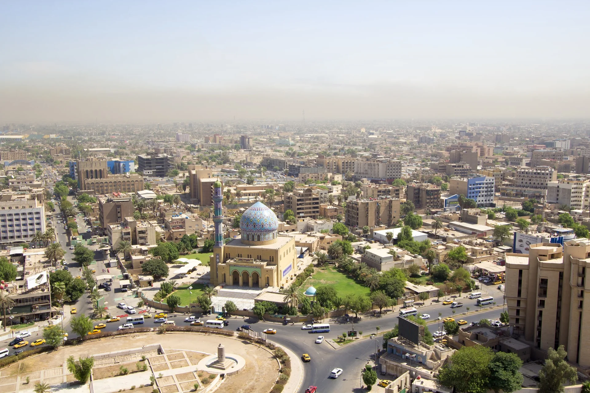
Bagdad (arabisch بغداد Baghdad, DMG Baġdād, kurdisch بەغدا Beẍda, von persisch „Geschenk des Herrn“ bzw. „Gottesgeschenk“, entsprechend baġ „Gott, Herr“ und dād „Gabe“)[1] ist die Hauptstadt des Iraks und des gleichnamigen Gouvernements. Sie ist mit ca. 6,7 Millionen Einwohnern (2018)[2] eine der größten Städte im Nahen Osten. In der Metropolregion, die weit über die Grenzen des Gouvernements hinausreicht, leben ca. 8,1 Millionen Menschen (2018), was knapp einem Viertel der Gesamtbevölkerung des Iraks entspricht.[2]
Die Stadt ist das politische, wirtschaftliche und kulturelle Zentrum des Landes sowie Sitz der irakischen Regierung, des Parlaments, aller staatlichen und religiösen Zentralbehörden sowie zahlreicher diplomatischer Vertretungen. Bagdad ist der bedeutendste Verkehrsknotenpunkt Iraks und besitzt zahlreiche Universitäten, Hochschulen, Theater, Museen sowie Baudenkmäler.
巴格达(阿拉伯语:بغداد,阿拉米语:ܒܓܕܐܕ),古称报达,《诸蕃志》称 白达,伊拉克首都,同时它也是伊拉克巴格达省的首府,为伊拉克最大城市及经济文化中心。位于美索不达米亚平原中部地区,底格里斯河流过巴格达市区,而距幼发拉底河约30千米[3]。巴格达人口约577万,在阿拉伯世界位于开罗之后列第二位。在历史上,巴格达曾是伊斯兰文明的政治、宗教、经济、商业、学术、交通中心。巴格达也是一座多民族多教派的城市。
阿拔斯王朝第二任哈里发曼苏尔于公元762年将阿拉伯帝国都城迁至此地。当时成为阿拉伯世界的政治、经济、宗教中心。[3]
10世纪后,因政治变动及战争而衰退[3]。随着阿拉伯王朝不复昔日光辉,巴格达先于1258年被蒙古人攻陷;1508年和1534年分别被波斯和土耳其人占领。1638年后巴格达长期受土耳其人的统治。1917年巴格达落入英军之手。直到1921年伊拉克独立后,巴格达被定为首都。巴格达位于美索不达米亚平原中部地区,底格里斯河流过巴格达市区,而距幼发拉底河约30千米,为两河相距最近之处;迪亚拉河流经城市郊区,并于巴格达东南方注入底格里斯河。
バグダード(アラビア語: بغداد/ラテン文字表記: Baghdad, Baġdād)は、イラクの首都で同国最大の都市。また、バグダード県の県庁所在地でもある。アッバース朝によって建設された古都であり、イスラム世界における主要都市の1つ。2020年の人口はおよそ714.4万人[1]。日本語では多くの場合バグダッドと表記されるが、アラビア語の綴りと発音([bæɣˈdæːd])に近づけるとバグダードという表記になる。
Baghdad (/ˈbæɡdæd, bəɡˈdæd/; Arabic: بَغْدَاد [baɣˈdaːd] (![]() listen)) is the capital of Iraq and the second-largest city in the Arab world after Cairo. It is located on the Tigris near the ruins of the ancient Akkadian city of Babylon and the Sassanid Persian capital of Ctesiphon. In 762 CE, Baghdad was chosen as the capital of the Abbasid Caliphate, and became its most notable major development project. Within a short time, the city evolved into a significant cultural, commercial, and intellectual center of the Muslim world. This, in addition to housing several key academic institutions, including the House of Wisdom, as well as a multiethnic and multi-religious environment, garnered it a worldwide reputation as the "Center of Learning".
listen)) is the capital of Iraq and the second-largest city in the Arab world after Cairo. It is located on the Tigris near the ruins of the ancient Akkadian city of Babylon and the Sassanid Persian capital of Ctesiphon. In 762 CE, Baghdad was chosen as the capital of the Abbasid Caliphate, and became its most notable major development project. Within a short time, the city evolved into a significant cultural, commercial, and intellectual center of the Muslim world. This, in addition to housing several key academic institutions, including the House of Wisdom, as well as a multiethnic and multi-religious environment, garnered it a worldwide reputation as the "Center of Learning".
Baghdad was the largest city in the world for much of the Abbasid era during the Islamic Golden Age, peaking at a population of more than a million.[3] The city was largely destroyed at the hands of the Mongol Empire in 1258, resulting in a decline that would linger through many centuries due to frequent plagues and multiple successive empires. With the recognition of Iraq as an independent state (formerly the British Mandate of Mesopotamia) in 1932, Baghdad gradually regained some of its former prominence as a significant center of Arab culture, with a population variously estimated at 6 or over 7 million.[note 1] Compared to its large population, it has a small area at just 673 square kilometers (260 sq mi).
The city has faced severe infrastructural damage due to the Iraq War, which began with the United States-led invasion of Iraq in 2003 and lasted until 2011, and the subsequent insurgency and renewed war that lasted until 2017, resulting in a substantial loss of cultural heritage and historical artifacts. During this period, Baghdad had one of the highest rates of terrorist attacks in the world. However, terrorist attacks are rare and have been declining since the territorial defeat of the Islamic State militant group in Iraq in 2017.
Bagdad ou Baghdad (en arabe : بغداد, baġdād, /baɣˈdaːd/ Écouter) est la capitale de l’Irak et de la province de Bagdad. Située au centre-est du pays, elle est traversée par le fleuve Tigre. Ses habitants sont appelés « Bagdadiens »1.
Avec une aire urbaine comprenant une population estimée à 10 millions d’habitants en 2012, c’est la plus grande ville d’Irak, ainsi que la deuxième ville la plus peuplée du monde arabe et du Moyen-Orient (derrière Le Caire, la capitale de l'Égypte). C'est un carrefour de communications aériennes, routières et ferroviaires d'une grande importance stratégique pour la république d'Irak.
Les origines de la ville actuelle remontent, au moins, au viiie siècle, avec, probablement, la présence de plusieurs petits foyers d'habitat antérieurs datant de la période préislamique. Elle fut la capitale de l'Empire abbasside à partir du viiie siècle et un centre de culture et de connaissance très important pendant des siècles, jusqu’au milieu du xiiie siècle. Bagdad a été, de 2003 à 2011, le centre d’un violent conflit en raison de la guerre d’Irak. Elle est devenue une ville d'enclaves fortifiées régies par les soldats de l'armée irakienne, les officiers de la police fédérale, les agents de police locaux et les agents de sécurité privés.
Baghdad (in arabo: بغداد, Baghdād, in età abbaside Madīnat al-Salām, "Città della pace", in italiano antico Baldacco, Baldacca o Baudac), o Bagdad[4], è la capitale dell'Iraq e dell'omonima provincia. È la seconda città più grande dell'Asia sud-occidentale, dopo Teheran: il calcolo della popolazione per il 2014 è di 7 665 292 abitanti[3]. Situata sul fiume Tigri a 33°20 nord e 44°26 est.
Bagdad3 (en árabe: بَغْدَاد Baġdād, en arameo: ܒܓܕܕ Baghdad) es la capital y la ciudad más poblada de Irak. Su número de habitantes es de 8 765 000 (est. 2016), lo que la convierte en la mayor ciudad del país y la segunda del mundo árabe, solo por detrás de El Cairo.
Ubicada a orillas del río Tigris, la ciudad fue fundada en el siglo viii y se convirtió en capital del Califato abasí. En poco tiempo se convirtió en un centro cultural, comercial e intelectual de gran relevancia del mundo islámico. Esto, y el hecho de ser sede de varias instituciones académicas relevantes, como la Casa de la sabiduría, le sirvieron a la ciudad para ganarse una reputación mundial de «Centro de Enseñanza».
Bagdad fue la ciudad más grande de la Edad Media durante gran parte del Califato abasí, cuando alcanzó un pico de un millón y medio de habitantes.4 Sin embargo, la urbe fue en gran parte destruida por las tropas del Imperio mongol en 1258, lo que resultó en un declive que se prolongaría por muchos siglos debido a frecuentes epidemias y la sucesión de varios imperios que dominaron la ciudad. Con el reconocimiento de Irak como estado independiente en 1938 tras la desaparición del Mandato Británico para Mesopotamia, Bagdad recuperó gradualmente parte de su pasada preeminencia como centro significante de la cultura musulmana.
En tiempos recientes la ciudad ha sufrido graves daños en sus infraestructuras, especialmente durante la invasión de Irak de 2003 y la consiguiente guerra de Irak que duró hasta diciembre de 2011. En los últimos años la capital ha sido objetivo de numerosos ataques de la guerrilla iraquí. Este conflicto militar también ha provocado una pérdida profunda e irreparable de la herencia cultural y de piezas históricas. Como resultado, Bagdad está considerado uno de los lugares menos hospitalarios del mundo en los que vivir y ofrece una calidad de vida muy baja.
Багда́д (араб. بغداد — «божий дар») — столица Ирака, административный центр мухафазы Багдад. С населением более 9 млн человек (2015)[3] он является одним из самых больших городов Ближнего Востока.
Багдад — политический, экономический и культурный центр Ирака. В нём находятся правительство, все центральные государственные и религиозные учреждения и множество дипломатических представительств. Город — важный транспортный узел. В нём также расположены многочисленные вузы, театры, музеи и памятники архитектуры.
 Geography
Atomic bomb
Commonwealth of Nations
Geography
Atomic bomb
Commonwealth of Nations


 Military, defense and equipment
Nuclear Weapon
Pakistan
Silk road
Shanghai Cooperation Organization
Military, defense and equipment
Nuclear Weapon
Pakistan
Silk road
Shanghai Cooperation Organization
 States of Asia

 Azerbaijan
Eurovision Song Contest,ESC
UEFA European Championship 2020
History
Silk road
Azerbaijan
Eurovision Song Contest,ESC
UEFA European Championship 2020
History
Silk road
 World Heritage
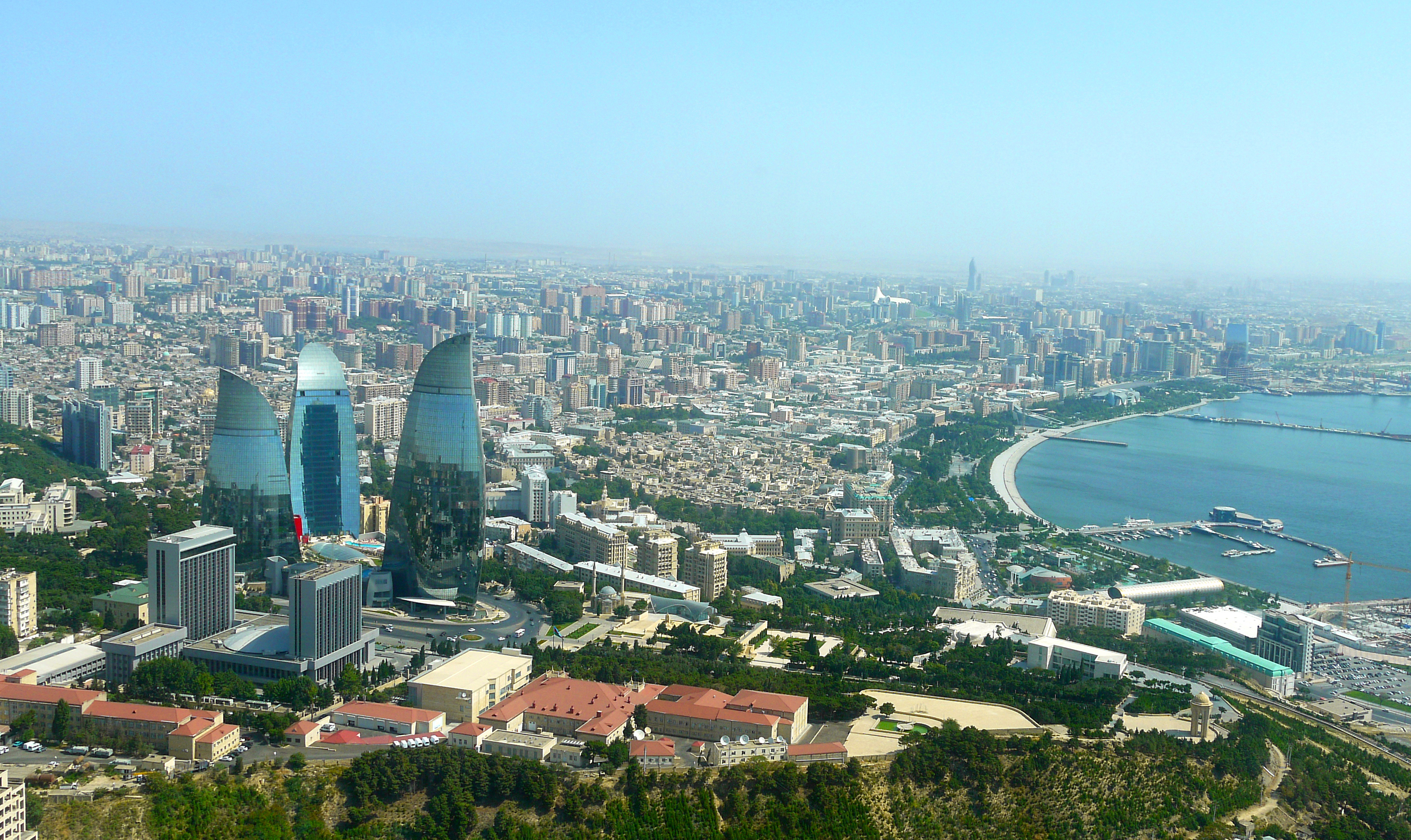
Baku (aserbaidschanisch Bakı / باکی; russisch Баку́ Baku) ist die Hauptstadt Aserbaidschans. Mit zwei Millionen Einwohnern in der Stadtprovinz ist Baku die bevölkerungsreichste und flächengrößte Stadt des Landes und des gesamten Kaukasus. Die Stadt an der Küste des Kaspischen Meeres ist Verkehrsknotenpunkt sowie Wirtschafts- und Kulturzentrum mit mehreren Universitäten, Hochschulen, Forschungsinstituten, Theatern und Museen. Durch die Lage innerhalb eines Erdölfördergebiets ist Baku der Knotenpunkt mehrerer Erdölleitungen und besitzt einen bedeutenden Erdölhafen. Baku kann aufgrund seiner günstigen Lage an mehreren historischen Handelswegen auf eine reiche Stadtgeschichte zurückblicken. In der Altstadt, die seit 2000 den Status eines UNESCO-Welterbes hat, sind zahlreiche Paläste, Moscheen und Festungsbauten erhalten geblieben.
巴库(Baku, Баку)是阿塞拜疆首都和全国经济、文化中心。里海最大港口。位于阿普歇伦米岛南部,是石油工业中心,有“石油城”之誉。也是前苏联外高加索最大城市。 巴库由10个行政区和46个城镇组成,面积2200平方公里。人口182.88万。1月平均气温为4℃,7月平均气温为27.3℃。 在18世纪,巴库为巴库汗国都城。19世纪70年代开始工业性采油,19世纪末成为外高加索工业中心和石油基地,有22大炼油基地,其他工业多与石油有 关。1991年8月成为独立后阿塞拜疆的首都。城市西部的比比埃巴特区为老采油区。东部的基什雷区和邵武勉区为重要工业区。石油是巴库的经济命脉。石油开 采正向深处和外围海域发展。以石油、天然气开采和石油加工为主要工业,还有石油机械、电力和轻工 、食品工业。外高加索主要铁路枢纽,铁路通罗斯托夫、第比利斯和埃里温。有输油管道通黑海港口巴统。巴库是里海航运中心,可泊中等吨位船舶。城市中部为行 政、文化和居住区。建有科学院,大学和博物馆。里海最大港口,有“石油城”之誉。市内建有地铁,有阿塞拜疆科学学院、阿塞拜疆大学、石油化工学院等多所高 等院校。城市的中部是行政、文化区域,有历史博物馆和艺术博物馆。老城区以旧要塞为中心。 巴库是一座有着悠久历史的古城,城内有众多名胜古迹,如11世纪建造的瑟纳克一卡尔清真寺塔,12世纪的克孜一卡拉瑟塔楼,13世纪的巴伊洛夫石堡,15 世纪的希尔凡王宫及17世纪的汗王宫殿至今保存完好。2000年联合国教科文组织将巴库墙城及城内的希尔梵国王宫殿和少女塔作为文化遗产,列入《世界遗产 名录》。(Quelle:http://you.kuxun.cn)
巴库(阿塞拜疆语:Bakı)是阿塞拜疆的首都、经济文化中心。巴库同时也是里海最大港口,外高加索最大城市[3]。面积2192平方千米,人口300万(2008年计算)[1]。巴库全市分为内城和新城两部分(亦有将苏联时期兴建区域分别划分的)。
在2007年,伊斯兰会议组织文化部长宣布巴库为2009年伊斯兰文化中心。为2015年第一届欧洲运动会主办国。巴库曾先后申办2016年夏季奥运会和2020年夏季奥运会,但皆因基础设施不完备没有入围。不过由于阿塞拜疆歌手艾尔与妮基在2011年欧洲歌唱大赛获得冠军,终使巴库获得举办2012年欧洲歌唱大赛的机会。
バクー(Baku)は、アゼルバイジャン共和国の首都。カスピ海西岸に突き出したアブシェロン半島南岸に位置し、市街はバクー湾に面するように広がった港町である。行政的には11の行政区、48の町区に分割されており、2005年時点の総人口は2,045,815人[1]。アゼルバイジャン最大の都市であると同時に、南カフカース地域でも有数の大都市である。大規模な油田(バクー油田)をもち、帝政ロシア時代から石油の生産地として発展してきた。
日本語名のバクーはキリル文字綴りによるロシア語綴り・アゼルバイジャン語(アゼリー語)旧綴り Баку (Baku) に基づくが、アゼルバイジャン語の発音では母音の前で子音 k が軟音化するためカタカナ表記するならば「バキュ」に近く、現在アゼルバイジャンで使われているアゼルバイジャン語のラテン文字正書法では Bakı と綴る。バクーという名前の由来には諸説あるが、最も一般的なものは、ペルシャ語で「風が吹きつけた」という意味の "bād-kūbe"(バード・クーベ)から来ているとする説が一般的である。
気候は晴天が多く、乾燥している。寒気と暖気がぶつかることで起きる強風が時折吹き付け、先述した語源の根拠となっている。海岸は美しく、市街近郊には温泉や鉱泉がある。
市街の中心はその南西部にあり、イチェリ・シェヘル (İçəri Şəhər) すなわち「内城」と呼ばれる城壁に囲まれた旧市街と、帝政ロシア時代にその周囲に築かれた新市街とに分かれる。その周囲、北から東にかけての平地から丘陵の斜面一帯にソビエト連邦時代につくられた市街が広がっている。近年は豊富なオイルマネーをもとに近未来的な巨大建築物が出現し、「第二のドバイ」「第二のシンガポール」とも呼ばれている[2]。
Baku (/bəˈkuː/ bə-KOO, /ˈbɑːkuː/ BAH-koo; Azerbaijani: Bakı, IPA: [bɑˈcɯ]) is the capital and largest city of Azerbaijan, as well as the largest city on the Caspian Sea and of the Caucasus region, with a population of 2,262,600 (January 1, 2018). Baku is located 28 metres (92 ft) below sea level, which makes it the lowest lying national capital in the world and also the largest city in the world located below sea level. It is located on the southern shore of the Absheron Peninsula, alongside the Bay of Baku. At the beginning of 2009, Baku's urban population was estimated at just over two million people.[5] Officially, about 25 percent of all inhabitants of the country live in Baku's metropolitan area. Baku is the sole metropolis in Azerbaijan.
Baku is divided into twelve administrative districts (raions) and 48 townships. Among these are the townships on the islands of the Baku Archipelago, and the town of Oil Rocks built on stilts in the Caspian Sea, 60 kilometres (37 miles) away from Baku. The Inner City of Baku, along with the Shirvanshah's Palace and Maiden Tower, were inscribed as a UNESCO World Heritage Site in 2000. According to the Lonely Planet's ranking, Baku is also among the world's top ten destinations for urban nightlife.[6]
The city is the scientific, cultural, and industrial center of Azerbaijan. Many sizeable Azerbaijani institutions have their headquarters there. The Baku International Sea Trade Port is capable of handling two million tons of general and dry bulk cargoes per year.[7] In recent years, Baku has become an important venue for international events. It hosted the 57th Eurovision Song Contest in 2012, the 2015 European Games, 4th Islamic Solidarity Games, the F1 Azerbaijan Grand Prix since 2016, and will host UEFA Euro 2020. The city is bidding for Expo 2025 against Yekaterinburg, Russia and Osaka, Japan.
La ville de Bakou (azéri : Bakı, IPA: [bɑˈcɯ]) est la capitale de l'Azerbaïdjan. Elle se trouve dans l'est du pays, sur la rive sud de la péninsule d'Abşeron, au bord de la mer Caspienne. Son histoire débute au Ier millénaire avant Jésus-Christ, mais les traces écrites les plus anciennes ne datent que du Ve siècle.
En 2011, sa population est estimée à 2 045 815 habitants1 et 3 millions de personnes environ vivent dans l'agglomération.
Baku (pron. bakù[2]; in azero: Bakı?; in russo: Баку?), conosciuta anche come Baqy, Baky o Baki, in italiano Bacù[2], è la capitale, la più grande città e il più grande porto dell'Azerbaigian e di tutto il Caucaso.
È considerata una delle più antiche e più grandi città dell'Oriente. Situata sulla costa meridionale della penisola di Abşeron, la città si compone di tre parti principali: il centro, la vecchia Città Murata estesa sul territorio di 21,5 ettari e la parte della città costruita nell'epoca sovietica. La sua popolazione nel 2014 era stimata in 2.122.300 di abitanti.
Bakú (en azerí, Bakı, [bɑˈkɯ]) es la capital y ciudad más poblada de Azerbaiyán, del mar Caspio y del Cáucaso. Está situada en la costa sur de la península de Absheron, que se proyecta en el Caspio. La ciudad se compone de dos partes principales: el centro y la ciudad vieja interior. En enero de 2018 Bakú tenía una población de 2.262.600 habitantes,3 de los cuales 153.400 eran desplazados internos y 143.400 refugiados de la guerra de Nagorno Karabaj.
Bakú se divide en once distritos administrativos (raiones) y 48 municipios. Entre estos se encuentran los municipios de las islas de la bahía de Bakú y Neft Daşları construidas sobre pilotes en el mar Caspio, a 60 km de Bakú. El centro urbano de la ciudad, con el Palacio de los Shirvanshah y la Torre de la Doncella, fue inscrito por la Unesco como Patrimonio de la Humanidad en 2000. De acuerdo con la clasificación de Lonely Planet, Bakú también se encuentra entre los diez mejores destinos de vida nocturna urbana del mundo.4
La ciudad fue uno de los mayores centros petrolíferos de la antigua Unión Soviética y actualmente es el centro científico, cultural e industrial de Azerbaiyán. Muchas instituciones importantes de Azerbaiyán tienen su sede allí, incluyendo SOCAR, una de las cien principales empresas del mundo, entre otras.5 El Puerto de Comercio Marítimo Internacional de Bakú, protegido por las islas del archipiélago Bakú hacia el este y la península de Absheron al norte, es capaz de transportar dos millones de toneladas de carga general y seca a granel por año.6 La ciudad acogió el 57.º Festival de Eurovisión en 2012 y fue la sede de los Juegos Europeos 2015, es la sede del Gran Premio de Azerbaiyán de Fórmula 1 desde 2016 y será la sede del Campeonato Mundial de Ciclismo BMX en 2018 y de la EURO 2020.7
Баку́ (азерб. Bakı, МФА (азерб.): [bɑˈcɯ]) — столица Азербайджанской Республики, крупнейший промышленный, экономический и научно-технический центр Закавказья, а также самый крупный порт на Каспийском море и самый большой город на Кавказе[9][10].
Площадь территории, которая административно управляется Баку, составляет 2150 км²[1]; население данной территории — 2 181,8 тыс. жителей (на 1 января 2014 года). Баку расположен на южном берегу Апшеронского полуострова. Город по своей древности, величине территории и численности населения является одним из старинных и крупнейших городов Востока. Население всего Апшеронского полуострова (Бакинской агломерации) составляет 2 673,7 тыс. жителей[7]. Баку удостоен в 2010 году Программой ООН по окружающей среде (UNEP) звания одного из главных городов по проведению Всемирного дня окружающей среды. Подобные города избираются ежегодно. В 2010 году, наряду с Баку, этих званий были удостоены также Генуя (Италия) и Женева (Швейцария)[11].
 Architecture
Eurovision Song Contest,ESC
FIFA Fussball-Weltmeisterschaft 1998
Architecture
Eurovision Song Contest,ESC
FIFA Fussball-Weltmeisterschaft 1998
 Financial
***Global Financial Center
France
UEFA European Championship 2016
Women's Soccer World Cup 2019
History
N 2000 - 2100 AD
Financial
***Global Financial Center
France
UEFA European Championship 2016
Women's Soccer World Cup 2019
History
N 2000 - 2100 AD
 Ile-de-France
International cities
*European Capital of Culture
Ile-de-France
International cities
*European Capital of Culture
 Medieval cities in Europe
Olympic Summer Games
Silk road
Seine
Medieval cities in Europe
Olympic Summer Games
Silk road
Seine
 Cities founded by the Romans

Paris (französisch [paˈʁi]) ist die Hauptstadt der Französischen Republik und Hauptort der Region Île-de-France. Der Fluss Seine teilt die Stadt in einen nördlichen (Rive Droite, „rechtes Ufer“) und einen südlichen Teil (Rive Gauche, „linkes Ufer“); administrativ ist sie in 20 Stadtbezirke (Arrondissements) unterteilt. Mit mehr als 2,2 Millionen Einwohnern ist Paris die fünftgrößte Stadt der Europäischen Union sowie mit über 12,5 Millionen Menschen nach London die zweitgrößte Metropolregion der EU.[1][2][3][4] Mit einer vergleichsweise kleinen Stadtfläche von nur 105 Quadratkilometern ist Paris mit rund 21.000 Einwohnern pro Quadratkilometer die am dichtesten besiedelte Großstadt Europas.
Paris ist das überragende politische, wirtschaftliche sowie kulturelle Zentrum des zentralistisch organisierten Frankreichs und mit drei Flughäfen und sechs Kopfbahnhöfen dessen größter Verkehrsknotenpunkt. Teile des Seine-Ufers zählen heute zum UNESCO-Welterbe. Die Stadt ist Sitz der UNESCO und darüber hinaus der OECD und der ICC. Sehenswürdigkeiten wie der Eiffelturm, die Kathedrale Notre-Dame oder der Louvre machen die Stadt zu einem beliebten Touristenziel. Mit rund 16 Millionen ausländischen Touristen pro Jahr ist die Stadt hinter London und Bangkok eine der meistbesuchten Städte weltweit.[5] Der Großraum Paris (Île-de-France) verzeichnet jährlich über 47 Millionen Gäste aus dem In- und Ausland und mehr als 184 Millionen Übernachtungen.[6]
Das heutige Paris entwickelte sich seit dem 3. Jahrhundert aus der keltischen Siedlung „Lutetia“ auf der Île de la Cité. Später errichteten die Römer an der Seine eine Stadt, die im 6. Jahrhundert zunächst eine Hauptresidenz des Fränkischen Reiches wurde. Eine Blütezeit der Kunst und Kultur erlebte Paris im 16. Jahrhundert unter Franz I. Durch den Absolutismus, insbesondere unter Ludwig XIV. im 17. Jahrhundert, wurde die Stadt um zahlreiche barocke Gebäude und Prachtstraßen bereichert und so zu einem beispielhaften Muster für barocken Städtebau. Obwohl die Königsresidenz 1682 nach Versailles verlegt wurde, blieb sie aufgrund ihrer politischen und wirtschaftlichen Bedeutung das Zentrum des Landes. In der Französischen Revolution kam ihr ab 1789 eine welthistorische Bedeutung zu. Die Industrialisierung führte im 19. Jahrhundert zu einem enormen Bevölkerungszuwachs, sodass 1846 erstmals die Grenze von einer Million Einwohnern überschritten wurde. In den folgenden Jahrzehnten bekam die Stadt durch die sogenannte Belle Époque und sechs Weltausstellungen weltweite Beachtung. Heute ist sie Hauptort der französischsprachigen und eine der wichtigsten Städte der westlichen Welt.
巴黎市(法语:Paris)是法国的首都和最大城市,也是法国的政治与文化中心。其隶属法兰西岛大区之下的巴黎省(编号第75省;仅辖有1个同名的省区与市镇),也是法兰西岛大区的核心。目前所谓的巴黎市辖区范围大至仅为旧巴黎城墙内(环城道路内侧),并未包含巴黎扩张发展的大巴黎实际都市区域,巴黎市辖区内依照发展历史共分成20个区,,自从1860年代开始就没有重大变化。截至2009年为止,巴黎市内人口超过223万[1] ,巴黎都会区的人口逾1,200万[2] ,是欧洲最大的都会区之一[3]。
巴黎在将近1,000年的时间中是西方世界最大的城市,也曾经是世界上最大的城市(16世纪至19世纪之间)[4][5][6]。目前是世界上最重要的政治与文化中心之一,对于教育、娱乐、时尚、科学、媒体、艺术与政治等方面皆有重大影响力,被认为是世界上最重要的全球城市之一[7][8][9][10] ,一般普世观念上与日本东京、美国纽约、英国伦敦并列世界四大国际级都市。许多国际组织都将总部设立在巴黎,例如联合国教育、科学及文化组织、经济合作与发展组织、国际商会或巴黎俱乐部等。巴黎也是欧洲绿化最深[11] 与最适合人类居住的城市之一[12] ,也是世界上生活费用最高的城市之一[13][14]。
巴黎与法兰西岛大区大约贡献法国4分之1的国内生产总值,在2009年为5,521亿欧元[15] 。根据估计,巴黎是欧洲第一[16] 或第二大城市经济体,也是世界上第六大城市经济体[17]〈按购买力平价PPP调整〉。总共有33间财富世界500强企业的总部设立在巴黎都会区[18],是欧洲最集中的地区。巴黎市辖区范围外的商业区拉德芳斯是欧洲最大的中央商务办公区[19]。巴黎的高等教育机构是欧盟最集中的地区[20],高等教育研究与发展支出也是欧洲最高的地区。巴黎也被认为是世界上最适合研发创新的城市之一[21]。每年有4,200万人造访巴黎与邻近都会区,也让巴黎成为世界上最多观光客造访的城市[20]。巴黎与与邻近都会区总共有3,800个法国国家遗产与4个世界遗产[20]。巴黎也是1989年的欧洲文化之城。
パリ(仏: Paris[1]、巴里)は、フランス北部、イル=ド=フランス地域圏にある都市。フランスの首都であり、イル=ド=フランス地域圏の首府である。
フランス最大の都市であり、同国の政治、経済、文化などの中心である。ロンドン、ニューヨーク、香港、東京などと並ぶ世界トップクラスの世界都市でもある。行政上では、1コミューン単独で県を構成する特別市であり、ルーヴル美術館を含む1区を中心に、時計回りに20の行政区が並ぶ(エスカルゴと形容される[2])。
市域はティエールの城壁跡に造られた環状高速道路の内側の市街地(面積は86.99km2。参考:東京都・山手線の内側は63km2、ニューヨーク市・マンハッタンは59km2)、および、その外側西部のブローニュの森と外側東部のヴァンセンヌの森を併せた形となっており、面積は105.40 km2。ケスタ地形を呈するパリ盆地のほぼ中央に位置し、市内をセーヌ川が貫く。この川の中州であるシテ島を中心に発達した。市内の地形は比較的平坦であるが、標高は最低でセーヌ川沿いの35メートル、最高でモンマルトルの丘の130メートルである[3]。北緯49度とやや高緯度に位置するが、温かい北大西洋海流と偏西風によって一年を通して比較的温暖となっており、西岸海洋性気候の代表的な都市である。
世界有数の大都市であり、アメリカのシンクタンクが2017年に発表した総合的な世界都市ランキングにおいて、ロンドン、ニューヨークに次ぐ世界3位の都市と評価された[4]。日本の民間シンクタンクによる2017年発表の「世界の都市総合力ランキング」(森記念財団都市戦略研究所、森ビル)では、ロンドン、ニューヨーク、東京に次ぐ世界4位の都市と評価された[5]。フランス経済の中心地で、世界屈指の経済都市であり、多国籍企業の本社数や資本市場の規模などビジネス分野を総合評価した都市ランキングでは、ロンドンと共にヨーロッパでトップクラスであり、世界500大企業の本社数では、ニューヨークやロンドンを凌ぎ、西洋の都市では最多である。2014年のアメリカのダウ・ジョーンズらの調査によると、世界7位の金融センターと評価されており、欧州ではロンドンに次ぐ2位である[6]。
パリは年間外国人観光客数が世界一の観光都市である。歴史的な建物を観ることができ、ルーヴル美術館、ポンピドゥーセンターなどを始めとした一流の美術館で厖大な数の一流の美術品を観賞できる。また世界最古のバレエ団や、世界で最も古くから存在している劇団などの公演を楽しむこともできる。
パリ出身者・居住者は男性がパリジャン(仏: Parisien、フランス語発音: [parizjɛ̃] パリズィヤン)、女性がパリジェンヌ(仏: Parisienne、フランス語発音: [parizjɛn] パリズィエンヌ)と呼ばれる。1960年代以降、旧植民地であったアフリカ中部・北部やインドシナ半島、更に近年は中近東や東欧、中国などからの移民も増え、パリジャン・パリジェンヌも多民族・多人種化している。
市域人口は1950年代の約290万人を絶頂に減少し続けたが、ここ数年は微増傾向に転じており、2011年現在で約225万人である(INSEEによる)。2011年の近郊を含む都市的地域の人口では1,200万人を超えており、ロンドンを凌ぐEU最大の都市部を形成している[7]。
Paris (French pronunciation: [paʁi] ( listen)) is the capital and most populous city of France, with an area of 105 square kilometres (41 square miles) and a population of 2,206,488.[5][6] Since the 17th century, Paris has been one of Europe's major centres of finance, commerce, fashion, science, music, and painting. The Paris Region had a GDP of €681 billion (US$850 billion) in 2016, accounting for 31 per cent of the GDP of France.[7] In 2013–2014, the Paris Region had the third-highest GDP in the world and the largest regional GDP in the EU. According to the Economist Intelligence Unit Worldwide Cost of Living Survey in 2018, Paris was the second-most expensive city in the world, behind Singapore and ahead of Zurich, Hong Kong, Oslo and Geneva.[8]
The City of Paris's administrative limits form an East-West oval centred on the island at its historical heart, the Île de la Cité; this island is near the top of an arc of the river Seine that divides the city into southern Rive Gauche (Left Bank) and northern Rive Droite regions. Paris is the core of a built-up area that extends well beyond its limits: commonly referred to as the agglomération Parisienne, and statistically as a unité urbaine (a measure of urban area), the Paris agglomeration's 2013 population of 10,601,122 made it the largest urban area in the European Union.[3][not in citation given] City-influenced commuter activity reaches well beyond even this in a statistical aire urbaine de Paris (a measure of metropolitan area), that had a 2013 population of 12,405,426,[9] a number one-fifth the population of France,[10] the largest metropolitan area in the Eurozone.
The city is a major rail, highway, and air-transport hub served by two international airports: Paris-Charles de Gaulle (the second busiest airport in Europe after London Heathrow Airport with 69.5 million passengers in 2017) and Paris-Orly.[11][12] Opened in 1900, the city's subway system, the Paris Métro, serves 5.23 million passengers daily,[13] and is the second busiest metro system in Europe after Moscow Metro. Paris's Gare du Nord is one of the ten busiest railway stations in the world, with 262 million passengers in 2015.[14]
Paris is especially known for its museums and architectural landmarks: the Louvre was the most visited art museum in the world in 2017, with 8.1 million visitors.[15][16] The Musée d'Orsay and Musée de l'Orangerie are noted for their collections of French Impressionist art, and the Pompidou Centre Musée National d'Art Moderne has the largest collection of modern and contemporary art in Europe. The historical district along the Seine in the city centre is classified as a UNESCO Heritage Site. Popular landmarks in the centre of the city include the Cathedral of Notre Dame de Paris and the Gothic royal chapel of Sainte-Chapelle, both on the Île de la Cité; the Eiffel Tower, constructed for the Paris Universal Exposition of 1889; the Grand Palais and Petit Palais, built for the Paris Universal Exposition of 1900; the Arc de Triomphe on the Champs-Élysées, and the Basilica of Sacré-Coeur on the hill of Montmartre. Paris received 23 million visitors in 2017, measured by hotel stays, with the largest numbers of foreign visitors coming from the United States, the UK, Germany and China.[17][18] It was ranked as the third most visited travel destination in the world in 2017, after Bangkok and London.[19]
The football club Paris Saint-Germain and the rugby union club Stade Français are based in Paris. The 80,000-seat Stade de France, built for the 1998 FIFA World Cup, is located just north of Paris in the neighbouring commune of Saint-Denis. Paris hosts the annual French Open Grand Slam tennis tournament on the red clay of Roland Garros. Paris hosted the Olympic Games in 1900, 1924 and will host the 2024 Summer Olympics. The 1938 and 1998 FIFA World Cups, the 2007 Rugby World Cup, and the 1960, 1984, and 2016 UEFA European Championships were also held in the city and, every July, the Tour de France bicycle race finishes there.
Paris (prononcé [pa.ʁi] Écouter) est la capitale de la France. Elle se situe au cœur d'un vaste bassin sédimentaire aux sols fertiles et au climat tempéré, le bassin parisien, sur une boucle de la Seine, entre les confluents de celle-ci avec la Marne et l'Oise. Ses habitants s’appellent les Parisiens. Paris est également le chef-lieu de la région Île-de-France et l'unique commune française qui est en même temps un département. Commune centrale de la métropole du Grand Paris, créée en 2016, elle est divisée en arrondissements, comme les villes de Lyon et de Marseille, au nombre de vingt. L’État y dispose de prérogatives particulières exercées par le préfet de police de Paris.
Ville la plus peuplée de France, elle est quatrième parmi les aires urbaines européennes derrière Moscou, Istanbul et Londres et la 29e plus peuplée du monde. Paris compte 2,21 millions d'habitants au 1er janvier 2015. L'agglomération parisienne s’est largement développée au cours du XXe siècle, rassemblant 10,71 millions d'habitants au 1er janvier 2015, et son aire urbaine (l'agglomération et la couronne périurbaine) comptait 12,53 millions d'habitants.
La position de Lutèce, sur une île permettant le franchissement du grand fleuve navigable qu'est la Seine par une voie reliant le Nord et le Sud des Gaules, en fait dès l'Antiquité une cité importante, capitale des Parisii, puis lieu de séjour d'un empereur romain. Sa position au centre du territoire contrôlé par les rois Francs la fait choisir comme capitale de la France à la place de Tournai. Située au cœur d'un territoire agricole fertile avec un climat humide et doux, Paris devient une des principales villes de France au cours du Xe siècle, avec des palais royaux, de riches abbayes et une cathédrale ; au cours du XIIe siècle, avec l'Université de Paris, la cité devient un des premiers foyers en Europe pour l’enseignement et les arts. Le pouvoir royal se fixant dans cette ville, son importance économique et politique ne cesse de croître. Ainsi, au début du XIVe siècle, Paris est l'une des villes les plus importantes du monde chrétien. Au XVIIe siècle, elle est la capitale de la principale puissance politique européenne, au XVIIIe siècle l'un des plus grands centres culturels de l’Europe et au XIXe siècle la capitale des arts et des plaisirs. Paris joue donc un rôle culturel, politique et économique majeur dans l’histoire de l'Europe et du monde occidental au cours du IIe millénaire.
Symbole de la culture française, abritant de nombreux monuments, la ville, surnommée la Ville Lumière, attire en 2017 près de 34 millions de visiteurs ce qui en fait une des capitales les plus visitées au monde. Paris occupe également une place prépondérante dans le monde dans le milieu de la mode, du luxe et de la haute gastronomie. La capitale française n'est jumelée qu'avec une seule autre ville, Rome, ce qui est valable dans l'autre sens, avec ce slogan : « Seul Paris est digne de Rome, seule Rome est digne de Paris ». Paris sera, par ailleurs, en 2024 la deuxième ville avec Londres à avoir accueilli trois fois les Jeux olympiques après ceux de 1900 et ceux de 1924.
La ville est, avec sa banlieue, la capitale économique et commerciale de la France, ainsi que sa première place financière et boursière. Elle accueillera en 2019 l'Autorité bancaire européenne. La région parisienne, avec un produit intérieur brut (PIB) de 649 milliards d'euros en 2014, est un acteur économique européen majeur et la première région européenne par le PIB régional, devant la Rhénanie du Nord-Westphalie (627 milliards d'euros) et le Grand Londres (509 milliards d'euros). Elle est également l'une des régions les plus riches d'Europe avec un PIB par habitant de 52 900 euros en 2014. Paris est le siège de plusieurs organisations internationales comme l'UNESCO ou l'OCDE.
La densité de ses réseaux ferroviaire, autoroutier et de ses structures aéroportuaires en font un point de convergence pour les transports nationaux et internationaux. Cette situation résulte d’une longue évolution, en particulier des conceptions centralisatrices des monarchies et des républiques, qui donnent un rôle considérable à la capitale dans le pays et tendent à y concentrer les institutions. Depuis les années 1960, les politiques gouvernementales oscillent toutefois entre déconcentration et décentralisation. La macrocéphalie dont est atteinte la ville se concrétise par la convergence de la plupart des réseaux routiers et ferroviaires du pays en son centre et des écarts démographiques et économiques disproportionnés entre la capitale et la province : près de 19 % de la population française vit dans l'aire urbaine de Paris.
París (en francés Paris, pronunciado [paʁi] (?·i)) es la capital de Francia y su ciudad más poblada. Capital de la región de Isla de Francia (o "Región Parisina"), es constituida en la única comuna unidepartamental del país. Está situada a ambos márgenes de un largo meandro del río Sena, en el centro de la cuenca parisina, entre la confluencia del río Marne y el Sena, aguas arriba, y el Oise y el Sena, aguas abajo.
La ciudad de París, dentro de sus estrechos límites administrativos, tiene una población de 2 273 305 habitantes en 2015.2 Sin embargo, en el siglo XX, el área metropolitana de París se expandió más allá de los límites del municipio de París, y es hoy en día, con una población de 12 405 426 habitantes en 2013, la segunda área metropolitana del continente europeo (después de Londres) y la 28ª del mundo.4
La región de París es junto con la de Londres, uno de los núcleos económicos más importantes de Europa.6 Con 607 000 millones de euros (845 000 millones de dólares), produjo más de una cuarta parte del producto interior bruto (PIB) de Francia en 2011.7 La Défense es el principal barrio de negocios de Europa,8 alberga la sede social de casi la mitad de las grandes empresas francesas, así como la sede de veinte de las 100 más grandes del mundo.
Durante el siglo XIX y XX junto con la ciudad de Londres, 9 París fue el centro de desarrollo de proyectos arquitectónicos dentro del marco de la Revolución Industrial y sus famosas exposiciones. Ejemplos de ello son: el Mercado de la Madeleine, en 1824; las Grandes Halles iniciadas en 1853 , las Galerie des Machines y la Torre Eiffel ambas realizadas en la exposición de París de 1889.
Es conocida también como la «Ciudad Luz» (la Ville lumière), es el destino turístico más popular del mundo, con más de 42 millones de visitantes extranjeros por año.10 Cuenta con muchos de los monumentos más famosos y admirados del orbe: la Torre Eiffel, la Catedral de Notre Dame, la avenida de los Campos Elíseos, el Arco de Triunfo, la Basílica del Sacré Cœur, el Palacio de Los Inválidos, el Pante&
 Science and technology
 Cataluña
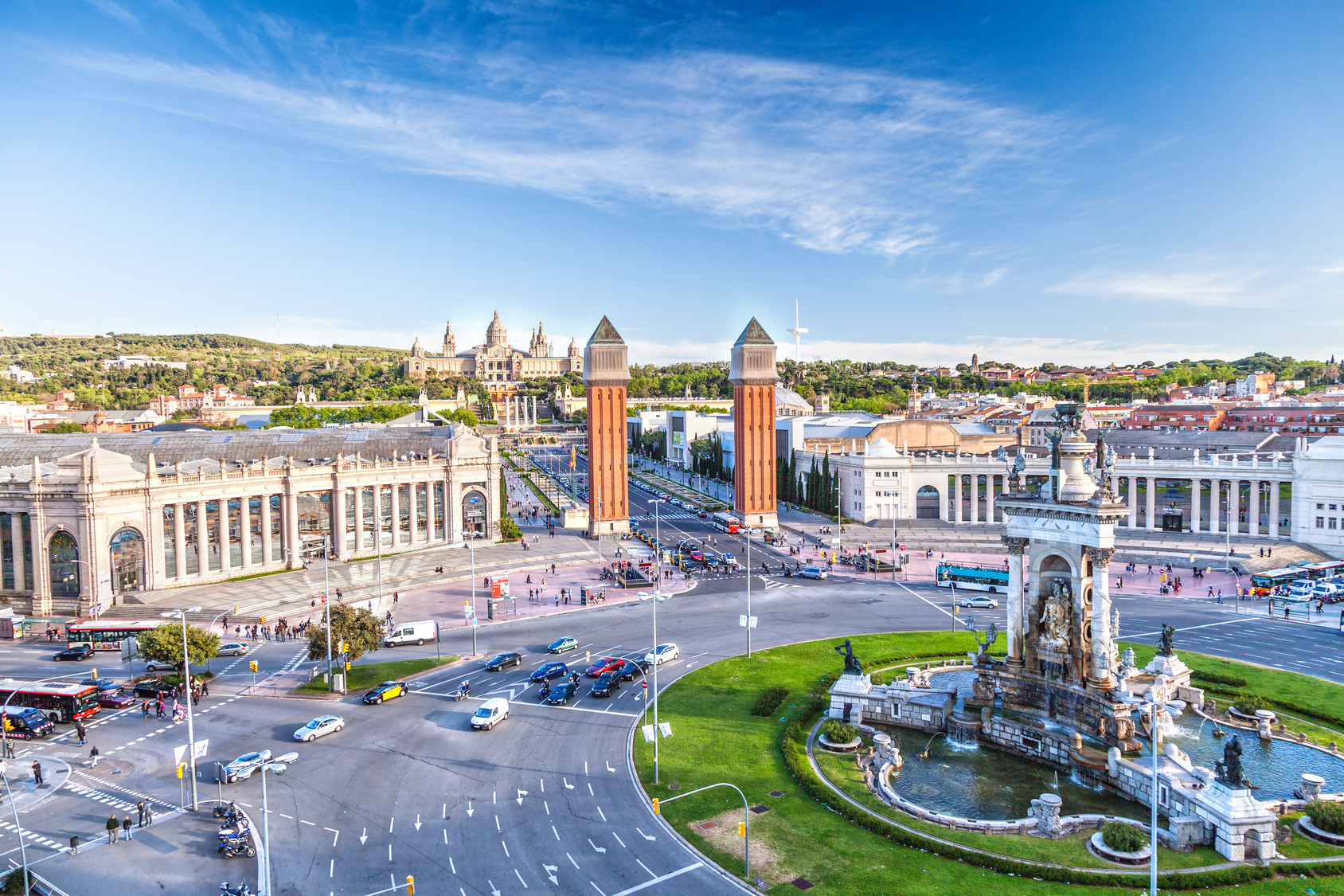
Barcelona (katalanisch [bəɾsəˈɫonə]; spanisch [baɾθeˈlona]; deutsch [baɐ̯səˈloːna] oder [baɐ̯t͡səˈloːna]) ist die Hauptstadt Kataloniens und nach Madrid die zweitgrößte Stadt Spaniens. Sie liegt am Mittelmeer, circa 120 Kilometer südlich der Pyrenäen und der Grenze zu Frankreich. Barcelona ist Verwaltungssitz der gleichnamigen Provinz und der Comarca Barcelonès.
Innerhalb des Stadtgebietes leben etwa 1,65 Millionen Menschen. Damit ist Barcelona die elftgrößte Gemeinde der Europäischen Union, nach Hamburg die zweitgrößte, die nicht die Hauptstadt eines Mitgliedstaates ist, und nach Paris die am zweitdichtesten besiedelte Millionenstadt Europas. Zusammen mit den in der Àrea Metropolitana de Barcelona zusammengeschlossenen Gemeinden der Agglomeration beträgt die Einwohnerzahl 3,16 Millionen. Im weiteren Einzugsbereich der Metropolregion (Àmbit Metropolità de Barcelona) leben insgesamt 4,86 Millionen Menschen. Mit jährlich mehr als sieben Millionen Touristen aus dem Ausland zählt Barcelona überdies zu den drei meistbesuchten Städten Europas.[2]
这座城市在展示通俗文化的同时,也没有忘记根深蒂固的传统。比如说,梅尔塞节还有在格拉西亚区、桑斯区或波布雷诺区举办的节庆活动,都向游客提供着不可多得的认识巴塞罗那的欢庆一面的机会。
以蔬果,新鲜水产香肠和橄榄油为基本原料,传统与现代相融合的烹饪手艺可以烹制出具有革新性又富有想象力的美食。于此,手工糖果和泡沫葡萄酒只能浅浅地触摸到巴塞罗那饮食文化的精髓。
巴塞罗那(加泰罗尼亚语:Barcelona,西班牙语:Barcelona)是西班牙加泰罗尼亚首府和巴塞罗那省省会,位于伊比利亚半岛的东北面,濒临地中海,全市人口约160万,都会区人口则约500万,为加泰罗尼亚第一大城。加泰罗尼亚的议会、行政机构、高等法院等政府中枢机构,以及最高首长均驻设于此。1999年,巴塞罗那由美国《国家地理杂志》评选为50个人生必游景点之一。
相传巴塞罗那由迦太基将领、汉尼拔的父亲哈米尔卡·巴卡所兴建,在其漫长的历史上还曾作为巴塞罗那伯爵领地和阿拉贡王国的都城。巴塞罗那因其众多历史建筑和文化景点成为众多旅游者的目的地,其中之代表是被列入联合国世界遗产的安东尼·高第和路易·多门内克·蒙塔内的建筑作品。安东尼·高第一直在巴塞罗那生活和工作,在这里有他很多的作品,其中最著名的包括桂尔宫、桂尔公园和圣家堂。巴塞罗那尚有两个知名的足球俱乐部:巴塞罗那和皇家西班牙人,其中巴塞罗那是世界最著名的足球俱乐部之一。
Barcelona (/ˌbɑːrsəˈloʊnə/ BAR-sə-LOH-nə, Catalan: [bəɾsəˈlonə], Spanish: [baɾθeˈlona]) is a city in Spain. It is the capital and largest city of Catalonia, as well as the second most populous municipality of Spain. With a population of 1.6 million within city limits,[5] its urban area extends to numerous neighbouring municipalities within the Province of Barcelona and is home to around 4.8 million people,[3][7] making it the sixth most populous urban area in the European Union after Paris, London, Madrid, the Ruhr area and Milan.[3] It is the largest metropolis on the Mediterranean Sea, located on the coast between the mouths of the rivers Llobregat and Besòs, and bounded to the west by the Serra de Collserola mountain range, the tallest peak of which is 512 metres (1,680 feet) high.
Founded as a Roman city, in the Middle Ages Barcelona became the capital of the County of Barcelona. After merging with the Kingdom of Aragon, Barcelona continued to be an important city in the Crown of Aragon as an economic and administrative centre of this Crown and the capital of the Principality of Catalonia. Barcelona has a rich cultural heritage and is today an important cultural centre and a major tourist destination. Particularly renowned are the architectural works of Antoni Gaudí and Lluís Domènech i Montaner, which have been designated UNESCO World Heritage Sites. The headquarters of the Union for the Mediterranean are located in Barcelona. The city is known for hosting the 1992 Summer Olympics as well as world-class conferences and expositions and also many international sport tournaments.
Barcelona is one of the world's leading tourist, economic, trade fair and cultural centres, and its influence in commerce, education, entertainment, media, fashion, science, and the arts all contribute to its status as one of the world's major global cities.[8][9] It is a major cultural and economic centre in southwestern Europe, 24th in the world (before Zürich, after Frankfurt)[10] and a financial centre. In 2008 it was the fourth most economically powerful city by GDP in the European Union and 35th in the world with GDP amounting to €177 billion.[11] In 2012 Barcelona had a GDP of $170 billion; and it was leading Spain in employment rate in that moment.[12]
In 2009 the city was ranked Europe's third and one of the world's most successful as a city brand.[13] In the same year the city was ranked Europe's fourth best city for business and fastest improving European city, with growth improved by 17% per year,[14] and the city has been experiencing strong and renewed growth for the past three years. Since 2011 Barcelona has been a leading smart city in Europe.[15] Barcelona is a transport hub, with the Port of Barcelona being one of Europe's principal seaports and busiest European passenger port,[16] an international airport, Barcelona–El Prat Airport, which handles over 40 million passengers per year,[17] an extensive motorway network, and a high-speed rail line with a link to France and the rest of Europe.[18]
Barcelone (Barcelona en catalan, prononcé /bəɾsəˈlonə/, et en espagnol, prononcé /baɾθeˈlona/) est la capitale administrative et économique de la Catalogne, de la province de Barcelone, de la comarque du Barcelonès ainsi que de son aire et de sa région métropolitaines, en Espagne.
Barcelone est la deuxième ville d'Espagne en termes de population, d'économie et d'activités, la onzième ville la plus peuplée de l'Union européenne et la sixième en incluant sa banlieue4: 4,84 millions de personnes vivent dans l'agglomération barcelonaise5. La majeure partie des municipalités adjacentes sont en outre rassemblées dans l'Aire métropolitaine de Barcelone.
Située sur le littoral méditerranéen, elle est traversée par les fleuves Llobregat et Besòs et bordée à l'ouest par la serra de Collserola qui culmine à 512 mètres (sommet : Tibidabo). Elle est considérée comme ville mondiale en raison de son importance dans les domaines de la finance, du commerce international, de l'édition, des arts, du divertissement et des médias. Barcelone est donc un centre économique majeur qui jouit de surcroît d'un des principaux ports méditerranéens et du deuxième aéroport espagnol derrière celui de Madrid-Barajas. Elle est aussi la ville qui possède le plus grand parc métropolitain du monde, le parc Collserola, devant Central Park à New York. Ayant été fondée par les Romains, la ville devint la capitale des comtes de Barcelone puis l'une des villes majeures de la Couronne d'Aragon et, après, la capitale de la principauté de Catalogne. Redessinée plusieurs fois pendant son histoire, elle est une destination touristique majeure et jouit d'un patrimoine culturel unique. Le palais Güell (en 1984), la Casa Milà, le parc Güell, le palais de la musique catalane et l'hôpital de Sant Pau figurent d'ailleurs sur la liste du patrimoine mondial de l'UNESCO. En outre, la ville est également connue pour avoir accueilli les Jeux olympiques en 1992 et, plus récemment, le siège de l'union pour la Méditerranée. Chaque année, les visiteurs arrivent par milliers et le nombre augmente de plus en plus. En 2015, un total de 8 988 038 touristes ont visité Barcelone6.
Barcellona (AFI: /barʧelˈlona/[1]; in catalano e spagnolo Barcelona) è una città di 1.620.809 abitanti (area metropolitana istituzionale: 3.239.337 abitanti) della Spagna, capoluogo della Catalogna, una comunità autonoma della parte nord-orientale dello Stato, oltre che dell'omonima provincia e della comarca del Barcelonès. Soprannominata Ciutat Comtal o Ciudad Condal (Città dei Conti), è la seconda città della Spagna per numero di abitanti dopo la capitale Madrid.
Nel 1992 fu sede dei Giochi Olimpici estivi. Nel 2004 vi si è tenuto per la prima volta assoluta il Forum Universale delle Culture, la città ha ospitato l'Esposizione internazionale del 1888 e quella del 1929, ed è la sede fissa del Mobile World Congress e dell'Unione per il Mediterraneo. Forte del turismo, del porto e della vicinanza alla Francia (160 km da Le Perthus), la città è il secondo maggior centro industriale e finanziario della Spagna dopo Madrid, nonché il maggior porto commerciale e turistico e uno dei maggiori d'Europa.
Barcelona es una ciudad española, capital de la comunidad autónoma de Cataluña, de la comarca del Barcelonés y de la provincia homónima.
Con una población de 1 620 809 habitantes en 2017,6 es la segunda ciudad más poblada de España después de Madrid, y la undécima de la Unión Europea. El área metropolitana de Barcelona, incluida en el ámbito metropolitano de Barcelona, cuenta con 5 029 181 habitantes (2011), siendo así la sexta ciudad de mayor población de la Unión Europea.78
Se ubica a orillas del mar Mediterráneo, a unos 120 km al sur de la cadena montañosa de los Pirineos y de la frontera con Francia, en un pequeño llano litoral limitado por el mar al este, la sierra de Collserola al oeste, el río Llobregat al sur y el río Besós al norte. Por haber sido capital del condado de Barcelona, se suele aludir a ella con la denominación antonomástica de Ciudad Condal.
La historia de Barcelona se extiende a lo largo de 4000 años, desde finales del Neolítico, con los primeros restos hallados en el territorio de la ciudad, hasta la actualidad. El sustrato de sus habitantes aúna a los pueblos íberos, romanos, judíos, visigodos, musulmanes y cristianos. Como capital de Cataluña y segunda ciudad en importancia de España, la Ciudad Condal ha forjado su relevancia con el tiempo, desde ser una pequeña colonia romana hasta convertirse en una ciudad valorada internacionalmente por aspectos como su economía, su patrimonio artístico, su cultura, su deporte y su vida social.
Barcelona ha sido escenario de diversos acontecimientos internacionales que han contribuido a consolidarla, desarrollarla y darle proyección mundial. Los más relevantes han sido la Exposición Universal de 1888, la Exposición Internacional de 1929, los Juegos Olímpicos de 1992 y el Fórum Universal de las Culturas 2004. Es también sede del secretariado de la Unión para el Mediterráneo.9
En la actualidad, Barcelona está reconocida como una ciudad global por su importancia cultural, financiera, comercial y turística. Posee uno de los puertos más importantes del Mediterráneo y es también un importante punto de comunicaciones entre España y Francia, debido a las conexiones por autopista y alta velocidad ferroviaria. El aeropuerto de Barcelona-El Prat, situado a 15 km del centro de la ciudad, fue utilizado por más de 47,2 millones de pasajeros en 2017.10