


This image, video or audio may be copyrighted. It is used for educational purposes only.

 China
Chongqing Shi-CQ
Gansu Sheng-GS
Henan Sheng-HA
Hubei Sheng-HB
China
Chongqing Shi-CQ
Gansu Sheng-GS
Henan Sheng-HA
Hubei Sheng-HB
 Review
Shaanxi Sheng-SN
Sichuan Sheng-SC
Review
Shaanxi Sheng-SN
Sichuan Sheng-SC
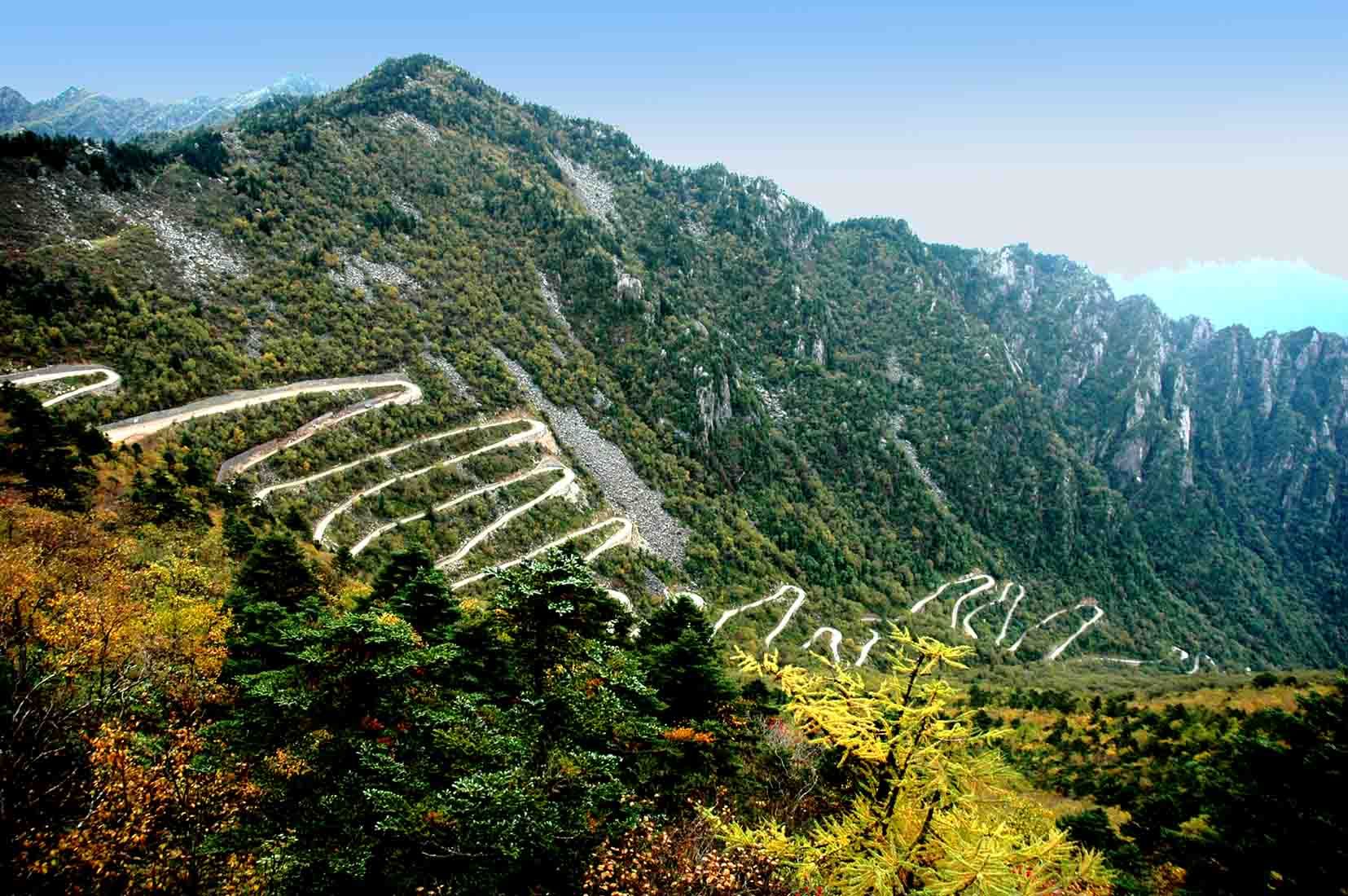
Der Qin-Ling (chinesisch 秦嶺 / 秦岭, Pinyin Qín Lǐng), auch Qin-Ling-Gebirgszug (秦嶺山脈 / 秦岭山脉, Qín Lǐng Shānmài) genannt, geografisch in der Mitte der Volksrepublik China, erstreckt sich in West-Ost-Richtung über etwa 1000 km Länge[1] (bei einer Breite von bis zu 170 km) vom Süden der Provinz Gansu über den gesamten Süden der Provinz Shaanxi bis zum zentralen Teil der Provinz Henan.
Der Taibai Shan ist mit 3767 m der höchste Berg des Qin Ling. Im Norden wird das Gebirge vom Wei-Fluss und im Süden vom Fluss Han Jiang begrenzt. Diese beiden Flüsse entwässern in die beiden großen chinesischen Ströme.
Das Gebirge bildet dadurch nicht nur eine Wasserscheide zwischen den Fluss-Systemen des Gelben Flusses und des Jangtsekiang, sondern auch eine markante Vegetationsgrenze. Während nördlich des Gebirgszuges trockene Lößregionen vorherrschen, die ideal für den Weizenanbau geeignet sind, beginnen südlich des Qin Ling die wärmeren, feuchteren Landstriche, in denen sich ausgedehnte Waldregionen mit Reisfeldern abwechseln.
秦岭是横贯中国中部的一座褶皱山脉,西起甘肃临洮,东到河南省的崤山、熊耳山-嵩山和伏牛山地区,主体位于陕西省中南部,是陕西省关中地区与陕南地区的分界线,呈东西走向,长1600公里。宽200~300公里,海拔2000~3000米。
秦岭-淮河线是中国地理上的南北分界线,秦岭同时也是长江流域与黄河流域的一个分水岭。狭义的秦岭是秦岭山脉的陕西段。位于秦岭山脉北面的关中平原为春秋战国时秦国的领地,在汉代即有“秦岭”之名;又因位于关中以南,故名“南山”。[1]
秦嶺山脈(しんれいさんみゃく)は、中国中部を東西に貫く山脈。黄河と揚子江を中流域で分けている。名前の由来は二千年前の秦の国にある山脈、秦嶺と称する。別名崑崙である。中国語でチンリンシャンマイ(Qínlǐng Shānmài)、英語でQinling Mountains。
古代中国に崑崙と呼ぶ。天下の龍脈の根と称する。唐以後の崑崙は現崑崙山脈である。唐の時代、古代アラビア人から販売された黒人たちを崑崙奴と言う。
西は甘粛省東部から東は河南省西部に及ぶ。平均海抜は2,000-3,000メートルであり、最高峰である太白山の海抜は3,767メートル。陝西省武功県から藍田県にわたる部分を終南山という。
トキ、ジャイアントパンダ、キンシコウなど、独特の稀少動物が生息し、ヤクタネゴヨウマツなどの独特の植物や、野生のキウイフルーツ、カホクザンショウなども見られる。
The Qinling (Chinese: 秦岭) or Qin Mountains, formerly known as the Nanshan ("Southern Mountains") and sometimes called the "Szechuan Alps", are a major east-west mountain range in southern Shaanxi Province, China. The mountains mark the divide between the drainage basins of the Yangtze and Yellow River systems, providing a natural boundary between North and South China and support a huge variety of plant and wildlife, some of which is found nowhere else on earth.
To the north is the densely populated Wei River valley, an ancient center of Chinese civilization. To the south is the Han River valley. To the west is the line of mountains along the northern edge of the Tibetan Plateau. To the east are the lower Funiu and Dabie Shan which rise out of the coastal plain.
The northern side of the range is prone to hot weather, however the physical barrier of the mountains mean that the land to the North has a semi-arid climate, with the lack of rich, fertile landscape that can not support a wealth of wildlife.[1] The mountains also acted as a natural defense against nomadic invasions from the North, as only four passes cross the mountains. In the late 1990s a railway tunnel and a spiral was completed, thereby easing travel across the range.[2]
The highest mountain in the range is Mount Taibai at 3,767 meters (12,359 ft), which is about 100 kilometers (62 mi) west of the ancient Chinese capital of Xi'an.[3] Three culturally significant peaks in the range are Mount Hua (2,155 meters or 7,070 feet), Mount Li (1,302 meters or 4,272 feet), and Mount Maiji (1,742 meters or 5,715 feet).
Les monts Qinling (chinois simplifié : 秦岭 ; chinois traditionnel : 秦嶺 ; pinyin : ; litt. « Cordillère des frênes ») sont une importante chaîne de montagnes de la Chine centrale, qui s'étend d'est en ouest sur près de 1 500 km.
Ils forment la principale barrière physique entre la vallée de la rivière Wei (affluent principal du fleuve Jaune) au nord et la plaine du Sichuan au sud ; ils constituent également la limite sud du plateau de Lœss. Leur plus haut sommet est le pic Taibai (3 767 m).
Ils sont le refuge d'espèces animales rares, en particulier du panda de Qinling, la seule sous-espèce de pandas reconnue.
I monti Qin (cinese: 秦岭; pinyin: Qin Ling; romanizzazione Wade-Giles: Ch'in Ling), noti anche come monti Tsinling, sono una catena montuosa della Cina settentrionale, estesa lungo un asse ovest-est dalla provincia del Gansu sud-orientale fino alle province di Shaanxi ed Henan. Considerati un'estensione orientale dei monti Kunlun, costituiscono uno spartiacque tra il fiume Wei a nord e il fiume Han a sud e culminano a 3767 m con il monte Taibai. La catena forma una netta divisione fisica, sia climatica che topografica, separando la zona subtropicale monsonica delle verdi colline ricoperte di foreste a sud dalle zone temperato-calde di aride distese di loess a nord. Questa divisione si prolunga verso est lungo i monti Dabie e il fiume Huai nella provincia dello Anhui.
Las montañas Qín (en chino tradicional, 秦嶺; en chino simplificado, 秦 岭; pinyin, Qinling) es una cadena montañosa del Asia Central, la mayor cordillera al sureste de la provincia de Shaanxi, República Popular China. La cordillera forma una frontera natural entre el norte y el sur del país. Su flora y fauna es muy variada y algunas especies no se encuentran en otro lugar de la tierra.
Al norte está el densamente poblado valle del río Wei, cuna de la antigua civilización china; al sur, el valle del río Han; al oeste, se encuentra la meseta Tibetana; y al este la cordillera pierde progresivamente altura.
El norte de la cordillera es propenso al clima cálido, sin embargo, la barrera física de las montañas significa que la tierra al norte goza de un clima semiárido, con la falta de un paisaje rico y fértil no puede sustentar una amplia variedad de vida silvestre.
Las montañas también actuaron como una defensa natural contra las invasiones nómadas del norte. A finales de 1990 se completóun túnel ferroviario, facilitando así los viajes en toda la cordillera.
La montaña más alta de la cordillera es el monte Taibai (太白 山) de 3.767 m, que está a 100 km de la ciudad capital Xi'an. Y la montaña más alta del este de China, el monte Hua (华山) de 2.155 m, también está en esta cordillera.
En ellas viven los pandas de Qinling, una subespecie de oso panda con las mismas manchas pero en tonos beige y marrón en vez de blanco y negro, además de un tamaño algo menor.
Циньли́н[1] (кит. трад. 秦嶺, упр. 秦岭, пиньинь Qin Ling) — горный хребет в Восточной Азии, расположен на территории Китая. Является восточным продолжением хребта Куньлунь. Тянется с запада на восток на 1000 км от юго-запада провинции Ганьсу в провинции Шэньси и Хэнань. Самая высокая точка — гора Тайбайшань (высота 3767 м).[2] Кроме того, вершиной хребта является одна из священных гор даосизма — Хуашань.
По хребту проходит водораздел бассейнов главных рек Китая — Хуанхэ и Янцзы. Протекающая с севера от хребта река Вэйхэ отделяет Циньлин от Лёссового плато, а долина реки Ханьшуй с юга — от хребтов Мицаншань и Бадашань, за которыми лежит Сычуаньская котловина. Хребет состоит преимущественно из известняка и метаморфических сланцев. Западная часть прорезана глубокими ущельями, восточная состоит из четырёх отдельных отрогов. Имеется месторождение молибденовых руд.[3]