


 Vacation and Travel


This image, video or audio may be copyrighted. It is used for educational purposes only.
Der Yalu (deutsch auch Jalu, in Nordkorea Amnokkang genannt) ist ein Grenzfluss zwischen der Volksrepublik China und Nordkorea.
Er entspringt auf 2500 m Seehöhe am Paektu-san im Changbai-Gebirge und fließt nach 813 km zwischen den Städten Dandong (China) und Sinŭiju (Nordkorea) in das Gelbe Meer. Die wichtigsten Zuflüsse des Yalu sind der Changjin-gang, der Hŏch’ŏn-gang und der Tongro-gang.
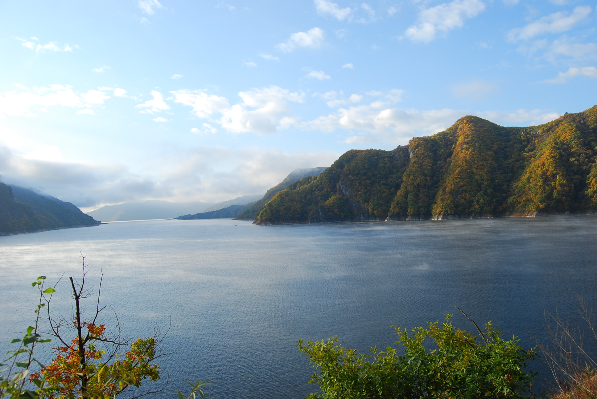
In Sup’ung-Rodongjagu (水豊勞動者區) am Yalu, stromaufwärts von Sinŭiju, wurde die Supung-Talsperre mit einem der größten asiatischen Wasserkraftwerke errichtet. Die Staumauer ist 160 m hoch und über 850 m lang. Da das Kraftwerk in einem Grenzfluss gebaut wurde, wird es von beiden Staaten gemeinsam betrieben. Der Unterlauf des Yalu ist schiffbar. Im Bereich der Mündung des Yalu befinden sich u. a. die Inseln Hwanggŭmp’yŏng und Pidan-sŏm.
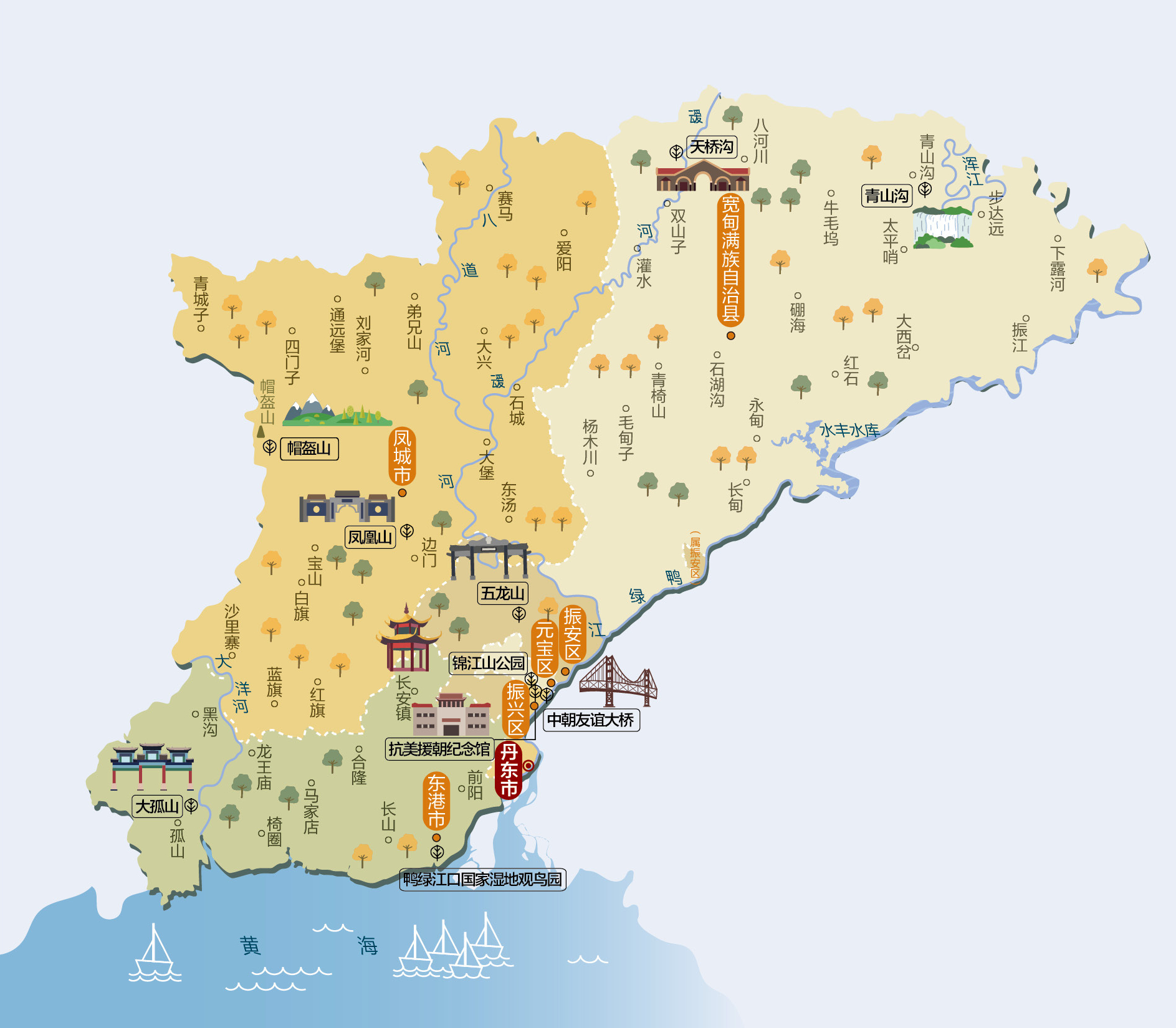
鸭绿江(朝鲜语:압록강/鴨綠江 Amnokkang */?满语:ᠶᠠᠯᡠ ᡠᠯᠠ Yalu ula;汉语拼音:Yālù jiāng),是位于中华人民共和国和朝鲜民主主义人民共和国之间的一条界江。入海口地区,朝方岛屿——绸缎岛和薪岛等与中方陆地接壤,因此鸭绿江江面末段完全在朝方一侧。目前河口为双方共用。 古称?水,汉朝称为马訾水,唐朝始称鸭绿江(隋唐时期?水为大同江),因其江水清澈,关于鸭绿江其名的来历主要流行着两种说法:一说因江水颜色似鸭头之色而得名(唐朝杜佑《通典》);二说因上游地区有鸭江和绿江两条支流汇入,故合而为一,并称为“鸭绿江”。另有源自于满族先民的语言(满语称为Yalu ula,意为“边界之江”)的说法。史书记载建州卫女真常年生活在婆猪江畔(鸭绿江支流)。鸭绿江发源于中国吉林省东南,中朝边境长白山主峰南麓海拔2300米处的长白山天池,然后流向西南,流经吉林省的长白朝鲜族自治县、临江市、集安市、辽宁省的丹东市,在辽宁省丹东市东港附近入黄海北部的西朝鲜湾。鸭绿江入海口是中国大陆海岸线的最北端。全长795公里,其中流经吉林省境界长575公里,辽宁省220公里;流域面积6.19万平方公里,中国境内流域面积约为3.25万平方公里。
鴨緑江(おうりょくこう、おうりょっこう、北京語:Yālù Jiāng、満州語:ᠶᠠᠯᡠ
ᡤᡳᠶᠠᠩ、 転写:yalu giyang[2]、朝鮮語:압록강)は、中華人民共和国(中国)東北部と朝鮮民主主義人民共和国(北朝鮮)との国境となっている川である。白頭山(中国名:長白山)に源を発し黄海に注ぐ。水の色が鴨の頭の色に似ていると言われたことからこの名前がある。
北岸は中国吉林省・遼寧省、南岸は北朝鮮慈江道・両江道・平安北道となっている。川沿いの主な都市としては、中国側に臨江、集安、丹東があり、北朝鮮側に慈城、満浦、楚山、新義州がある。
主な支流は赴戦江、長津江、虚川江で、いずれも北朝鮮側の蓋馬高原から北流して鴨緑江に合流しており、日本統治時代に大型ダムが建設されている。中国側からの支流には愛河などがある。
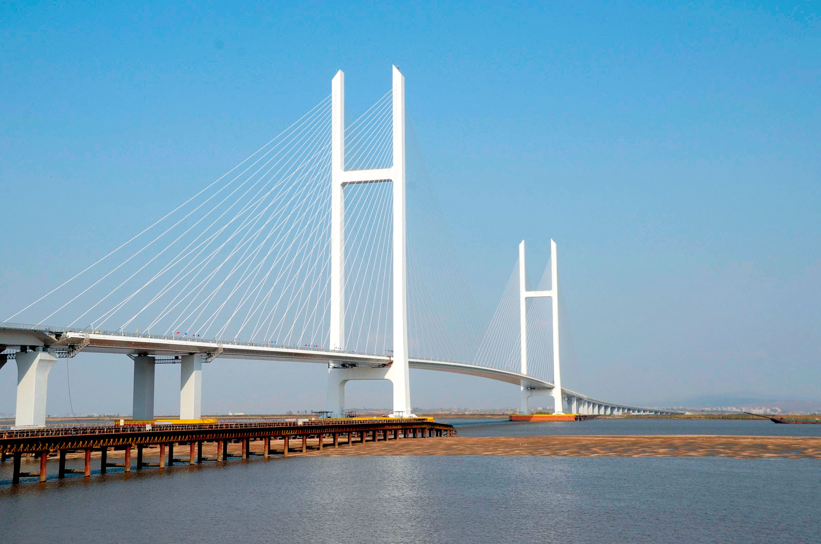
鴨緑江に架けられている橋の中では、下流の新義州と丹東を結ぶ中朝友誼橋が最もよく知られている。
流域では林業が盛んで、かつては上流部で伐採された木材を筏にして流していた。1930年代後半から1940年代初頭にかけて、日本によって中流域に竣工当時アジア最大級の水豊ダムが建設され、水力発電が行われるようになった。ここで生産される電力は、現在でも北朝鮮の重要なエネルギー源となっている。
The Yalu River, also called by Koreans the Amrok River or Amnok River, is a river on the border between North Korea and China. Together with the Tumen River to its east, and a small portion of Paektu Mountain, the Yalu forms the border between North Korea and China.
Two theories are given regarding the origin of the river's name. One theory is that the name derived from Yalu ula (ᠶᠠᠯᡠ
ᡠᠯᠠ) in the Manchu language. The Manchu word yalu (ᠶᠠᠯᡠ) means "the boundary between two countries". In Mandarin Chinese, yālù phonetically approximates the original Manchu word, but literally means "duck green", which was said to have been once the color of the river. The other theory is that the river was named after the combination of its two upper branches, which were called "鴨" (Yā or Ap) and "綠" (Lù or R(or n)ok)", respectively.
Revised Romanization of Korean spelled it Amnokgang (Korean pronunciation: [amnok.k͈aŋ]; "Amnok River") and Revised Romanization of Hangeul spelled it Aprokgang (Korean pronunciation: [amnok.k͈aŋ]; "Aprok River").
From 2500 m above sea level on Paektu Mountain on the China–North Korea border, the river flows south to Hyesan before sweeping 130 km northwest to Linjiang and then returning to a more southerly route for a further 300 km to empty into the Korea Bay between Dandong (China) and Sinuiju (North Korea). The bordering Chinese provinces are Jilin and Liaoning.
The river is 795 kilometers (494 mi) long and receives water from over 30,000 km² of land. The Yalu's most significant tributaries are the Changjin (장진강; 長津江), the Hochon (허천강; 虛川江), the Togro (독로강; 禿魯江) rivers from Korea and the Ai (or Aihe) (璦河) and the Hun (浑江) from China. The river is not easily navigable for most of its length.[1] Most of the river freezes during winter and can be crossed on foot.[2]
The depth of the Yalu River varies from some of the more shallow parts on the eastern side in Hyesan (1 meter (3 ft 3 in)) to the deeper parts of the river near the Yellow Sea (2.5 meters (8 ft 2 in)).[3] The estuary is the site of the Amrok River estuary Important Bird Area, identified as such by BirdLife International.[4]
About 205 islands are on the Yalu. A 1962 border treaty between North Korea and China split the islands according to which ethnic group was living on each island. North Korea possesses 127 and China 78. Due to the division criteria, some islands such as Hwanggumpyong Island belong to North Korea, but abut the Chinese side of the river.
Le Yalu (chinois simplifié : 鸭绿江 ; chinois traditionnel : 鴨綠江 ; pinyin : ), ou Amnok (en coréen : 압록강), est un fleuve qui marque la frontière entre la Chine et la Corée du Nord.
Il naît sur le Mont Paektu, point culminant de toute la Corée, à 2 500 m d'altitude et se jette dans la mer Jaune, après un parcours de 800 km orienté globalement vers le Sud-Ouest. Son bassin versant a une superficie de 30 000 km2.
Ses principaux affluents sont le Hunjiang (446 km), le Pushi et le Ai He (182 km) côté chinois ainsi que le Changjin, le Hochon et le Tongro côté coréen.
Trois barrages servent à l'approvisionnement en électricité : les barrages de Supung (765 MW), Yunfeng (400 MW) et Taipingwan.
Plusieurs ponts permettent de franchir le fleuve, dont les plus importants sont le Pont cassé du Yalu, détruit par les Américains pendant la Guerre de Corée et le pont de l'amitié sino-coréenne, qui lui est parallèle.
Il fiume Yalu (in cinese: 鴨綠江T, 鸭绿江S, Yālù JiāngP) o, in coreano, fiume Amnok (압록강?, 鴨綠江?, AmnokkangMR) forma parte del confine fra la Cina e la Corea del Nord. I due nomi in cinese e coreano sono le diverse pronunce degli stessi caratteri cinesi rappresentanti la parola Yalu ula in mancese. La sorgente si trova a circa 2500 m sul mare sulla montagna Baitou nei monti Changbai. Dopo circa 800 km il fiume sfocia nella Baia di Corea fra le città di Dandong in Cina e Sinŭiju nella Corea del Nord. Il bacino dello Yalu misura circa 39,800 km²[1].
El río Yalu o Yalú (en chino, 鸭绿江; Amrok-gang en Corea del Norte y Amnok-gang en Corea del Sur,압록강) es un río fronterizo entre China y Corea del Norte. El nombre chino proviene de una palabra manchú que significa «el límite entre dos campos».
Nace a 2500 metros sobre el nivel del mar en Paektu-san en las montañas de Changbai y fluye a lo largo de aproximadamente 800 kilómetros (según las fuentes, entre 813 y 790 km) desembocando entre las ciudades de Dandong (China) y Sinuiju (Corea del Norte), en el mar Amarillo. Los afluentes más importantes del Yalu son los ríos Changjin, Hŏch'ŏn y Tongro.
Ялуцзя́н (кит. 鸭绿江), Амноккан[1] (кор. 압록강?, 鴨綠江?, в старой русской географической литературе Амнокга́нг) — река на востоке Евразии, определяющая юго-западную часть границы между КНР и КНДР — на правом берегу располагается провинции КНР Ляонин и Гирин, на левом — провинции КНДР Пхёнан-Пукто и Чагандо.