
漢德百科全書 | 汉德百科全书
 International cities

 Mecklenburg-Vorpommern
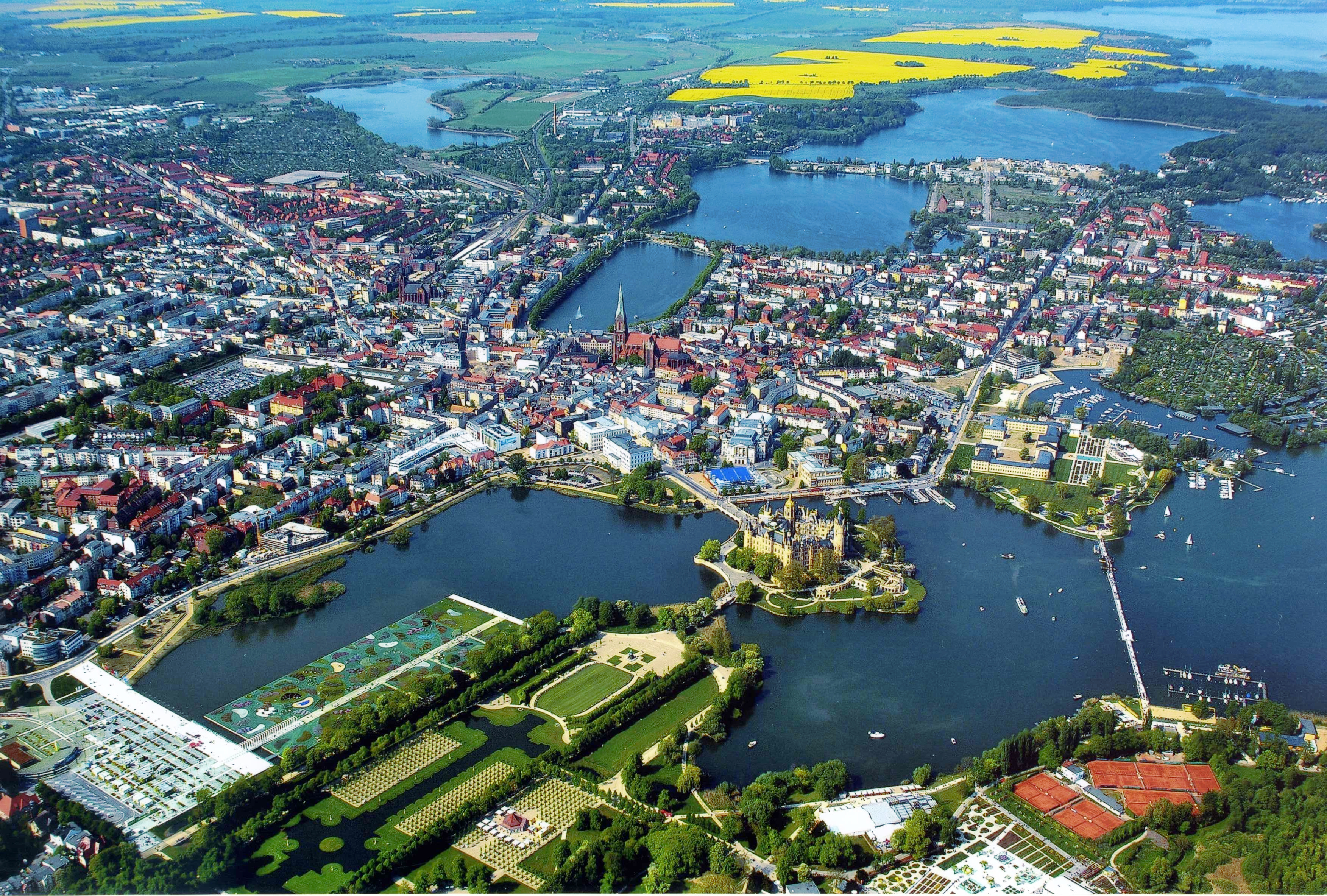
Schwerin ([ʃvɛˈʁiːn] oder [ʃvəˈʁiːn], mecklenburgisch Swerin) ist die Hauptstadt des Landes Mecklenburg-Vorpommern. Die kreisfreie Mittelstadt ist die kleinste Landeshauptstadt der Bundesrepublik Deutschland und zugleich die einzige, die keine Großstadt ist. Schwerin ist nach Rostock die zweitgrößte Stadt und eines der vier Oberzentren des Bundeslandes.
Schwerin wurde im Jahr 1018 erstmals als Wendenburg erwähnt und erhielt 1164 von Heinrich dem Löwen deutsche Stadtrechte. Damit ist sie die älteste Stadt im heutigen Mecklenburg-Vorpommern. Die Stadt dehnte sich im Laufe der Zeit am West- und Südufer des Schweriner Innensees aus, insgesamt befinden sich zwölf Seen innerhalb des Stadtgebietes. Ausgangspunkt der Stadtentwicklung war die Stelle mit dem heutigen Wahrzeichen der Stadt, dem Schweriner Schloss und dem Schlossgarten; es befindet sich auf einer Insel zwischen Schweriner See und Burgsee mit der Schlosskirche von 1560. Das Schloss war bis 1918 die Hauptresidenz der mecklenburgischen Herzöge und Großherzöge und das Machtzentrum des Herzogtums Mecklenburg-Schwerin, das 1919 zum demokratischen Freistaat wurde. Seit 1990 ist das Schloss Sitz des Landtags. Es war mit seinen umgebenden Gärten der Hauptveranstaltungsort der Bundesgartenschau 2009 und ist als historisch einmaliges Ensemble mit den weiteren Residenzbauten ein Kandidat für das UNESCO-Welterbe. Daneben zeichnet sich Schwerin durch seine – für eine deutsche Stadt dieser Größe ungewöhnlich gut erhaltene – Altstadt, die angrenzende Schelfstadt, das Kurviertel Zippendorf und weitere historische Viertel mit vielen Baudenkmalen aus.
Wirtschaftlich dominieren Technologieunternehmen, Behörden, die Deutsche Bahn, Maschinenbau und Materialverarbeitung, Konsumproduktion, Gesundheitswirtschaft und Kliniken, Dienstleistungsbetriebe, zunehmend auch der Tourismus und die Kultur- und Kreativwirtschaft. Zudem ist Schwerin Hochschulstandort mit rund 600 Studierenden, darunter die Hochschule der Bundesagentur für Arbeit und die Vitruvius Design-Hochschule. Sportlich ist Schwerin seit Fritz Sdunek als Boxerstadt und durch den zwölffachen deutschen Meister Schweriner SC als Volleyballstadt bekannt.
什未林(Schwerin),德国的一座古老城市,位于什未林湖区。什未林曾属于东德,在两德统一后,成为梅克伦堡-前波美拉尼亚州的首府。
梅克伦堡—前波美尼亚州首府。在什未林湖西南岸。人口12.8万(1984)。初为文德人村落。公元1018年见于史籍。1160年建市。铁路枢纽。工业有机械制造(船舶、农机、汽车等)、食品加工、化学、制革等,还有电缆、服装厂等。设有国家美术陈列馆、历史博物馆、音乐学院。有建于十三至十五世纪的哥特式教堂、十九世纪重建的宫殿。
在什未林湖的一个岛上,有一座童话般的城堡一什未林城堡,它建成于19世纪,是什未林的标志性建筑。在什未林城堡后面是景色非常美丽的城堡公园。
シュヴェリーン(低地ドイツ語: Swerin、標準ドイツ語: Schwerin [ʃvɛˈʁiːn, ʃvəˈʁiːn])は、ドイツ連邦共和国の都市。メクレンブルク=フォアポンメルン州の州都
Schwerin ([ʃvɛˈʁiːn] or [ʃvəˈʁiːn]; Mecklenburgian: Swerin; Polish: Swarzyn or Zwierzyn; Latin: Suerina) is the capital and second-largest city of the northeastern German state of Mecklenburg-Vorpommern. It has a population of about 100,000.[2]
Schwerin was first mentioned in 1018 as Wendenburg and was granted city rights in 1160 by Henry the Lion, thus it is the oldest city of Mecklenburg-Vorpommern. It is globally known for its romantic Schwerin Palace, situated on an island in the Lake Schwerin. The palace was one of the main residences of the dukes and grand dukes of Mecklenburg until 1918 and is the official seat of the state parliament since 1990. The city also has a largely intact old town, thanks to only minor damage in World War II.
Schwerin is located within the metropolitan region of Hamburg and close to that of Berlin, and to nearby regiopolises of Rostock and Lübeck. Major industries and employers include high technology, machine building, healthcare, government agencies, railway supply, consumer goods and tourism. Schwerin has three academic colleges, the FHM, HdBA and the Design School.
Schwerin est une ville-arrondissement d'Allemagne, capitale du Land de Mecklembourg-Poméranie-Occidentale. Avec 95 300 habitants (31 décembre 2011), elle est derrière Rostock la deuxième ville de la région. C’est la seule capitale régionale à compter moins de 100 000 habitants ce qui en fait la plus petite d’Allemagne.
La ville a pris naissance autour de son château, qui jusqu'en 1918 était la résidence princière des ducs et grands-ducs de Mecklembourg, et est depuis 1990 le siège du parlement régional. Au fil du temps, Schwerin s'est développée le long des rives ouest et sud du lac de Schwerin, jusqu'à enserrer douze lacs à l'intérieur du périmètre communal.
Schwerin o Suerina ([ʃvɛˈʁiːn] o [ʃvəˈʁiːn]) es la capital de Mecklemburgo-Pomerania Occidental (en alemán: Mecklenburg-Vorpommern), Alemania. Está situada a 80 km al sur del mar Báltico. Es la segunda ciudad más grande (después de Rostock) y uno de los cuatro centros económicos más importantes del Estado federado. Schwerin tiene alrededor de 96.000 habitantes y por eso es la capital más pequeña de los estados federados de Alemania.
Con el paso del tiempo la ciudad se amplió hacia el oeste y hacia el sur del lago Schweriner Innensee. Hoy en día hay doce lagos en el área de la ciudad. Ya a mediados del siglo X un viajero comercial informó de un castillo en un lago de agua dulce, un predecesor del Castillo de Schwerin, que fue hasta 1918 la residencia principal de los duques y de los gran duques de Mecklemburgo. Desde 1990 el castillo es la sede del parlamento regional (Landtag) del Estado federado.
Швери́н (нем. Schwerin [ʃvɛˈʁiːn, ʃvəˈʁiːn], н.-нем. Swerin, лат. Suerinum, Squirsina, Zuarina, полаб. Зверин, н.-луж. и в.-луж. Zwěrin, ист. чеш. Zvěřín) — город в Германии, административный центр федеральной земли Мекленбург-Передняя Померания. Располагается среди системы озёр, главным из которых является Шверинер-Зе.
 Vacation and Travel
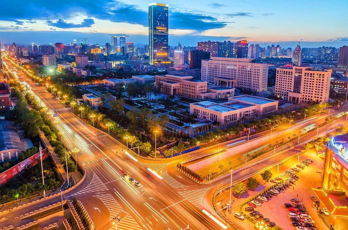
Shijiazhuang (chinesisch 石家莊市 / 石家庄市 Shíjiāzhuāng Shi) ist die Hauptstadt der Provinz Hebei der Volksrepublik China. Das Verwaltungsgebiet der bezirksfreien Stadt hat eine Fläche von 15.848 km² und ca. 9,77 Millionen Einwohner (Ende 2009).
Die Stadt wurde 1925 gegründet, formell zur Stadt erklärt am 7. Oktober 1939, damals unter dem Namen Shímén (石門). Am 26. Dezember 1947 wurde die Stadt in Shijiazhuang umbenannt. Xibaipo - ein wichtiger Ort der chinesischen Revolution - war im Befreiungskrieg der Sitz des Hauptquartiers des Zentralkomitees der Kommunistischen Partei Chinas.
Die in den Jahren zwischen 1986 bis 1993 gebaute, ca. 270 km lange Autobahn, welche Shijiazhuang mit Peking verbindet, war das erste größere chinesische Autobahnprojekt. Am 1. Januar 1989 gab es in ganz China 147 km Autobahn, heute werden in jedem Jahr durchschnittlich ca. 5.000 km neue Strecken im Land fertiggestellt.
石家庄跨华北平原和太行山地两大地貌单元,是全国粮、菜、肉、蛋、果主产区之一,农业集约化和产业化水平较高,生产规模位居全国36个重点城市第一位,被国家确定为优质小麦生产基地,素有“北方粮仓”之称。
石家庄市是中华人民共和国河北省的省会,位于河北省中南部,京津冀地区重要的中心城市,全国重要的现代服务业、生物产业基地之一[2],同时还是河北省的政治、经济、文化和对外交流的中心。地处华北平原腹地,北靠京津、西倚太行山、东濒渤海、南控黄淮海平原,位于京广铁路、石德铁路、石太铁路、石太客运专线、京石客运专线、石武客运专线和石济客运专线的交汇处,是重要的铁路枢纽。石家庄是一座由近代铁路的开通而发展起来的新兴都市。
石家荘市(せっかそうし/シージャーヂュァンし、中国語:石家庄市、拼音: 、英語:Shijiazhuang)は中華人民共和国河北省に位置する地級市。河北省の省都である。常住人口約1,078万人、都市圏人口約354万人[1]。都市圏人口で河北省最大の人口を持つ都市であり[2]、省内の経済・金融・文化の中心となっている。
Shijiazhuang (Chinese: 石家庄, [ʂɻ̩̌.tɕjá.ʈʂwáŋ]) is the capital and largest city of North China's Hebei Province.[1] Administratively a prefecture-level city, it is about 266 kilometres (165 mi) southwest of Beijing,[2] and it administers eight districts, two county-level cities, and 12 counties.
As of 2015 it had a total population of 10,701,600[3] with 4,303,700 in the central (or metro) area comprising the seven districts and the county of Zhengding largely conurbated with the Shijiazhuang metropolitan area as urbanization continues to proliferate.[4] Shijiazhuang's total population ranked twelfth in mainland China.[5]
Shijiazhuang experienced dramatic growth after the founding of the People's Republic of China in 1949. The population of the metropolitan area has more than quadrupled in 30 years[citation needed] as a result of industrialization and infrastructural developments. From 2008 to 2011, Shijiazhuang implemented a three-year plan which concluded with the reorganization of the city resulting in an increase of green areas and new buildings and roads. A train station, airport and a subway system have been opened.[6]
Shijiazhuang is situated east of the Taihang Mountains, a mountain range extending over 400 km (250 mi) from north to south with an average elevation of 1,500 to 2,000 m (4,900 to 6,600 ft), making Shijiazhuang a place for hiking, outdoor trips and cycling.
Shijiazhuang (石家庄 ; pinyin : Shíjiāzhuāng) est la capitale de la province du Hebei en Chine. On y parle le dialecte de Shijiazhuang du mandarin jilu. Shijiazhuang est une ville depuis 1939. Elle porte le nom Shijiazhuang depuis 1947, après s'être appelée Shimen. Shijazhuang est une ville relativement récente, créée dans les années 1950 et devenue la capitale de la province du Hebei dans les années 1970. Elle est connue comme la capitale la plus polluée de Chine. Elle compte dans la ville seule 2 millions d'habitants, son agglomération en compte plus de 9 et près de 13 dans son aire urbaine
Shijiazhuang (石家庄S, ShíjiāzhuāngP, letteralmente "Villaggio della famiglia Shí") è la capitale della provincia dell'Hebei in Cina. Si parla il dialetto di Shijiazhuang dal mandarino jilu. Shijiazhuang è una città dal 1939 e porta il nome attuale dal 1947, dopo essersi chiamata Shimen. Shijazhuang è diventata la capitale della provincia dell'Hebei negli anni settanta.
Shijiazhuang léase Shichiá-Zhuáng (en chino: 石家庄市, pinyin: Shíjiāzhuāng) es la ciudad capital de la provincia de Hebei y la ciudad más grande al norte de la República Popular China, teniendo una población total de 10 616 200 habitantes (2014).2
Шицзячжуан (кит. упр. 石家庄, пиньинь: Shíjiāzhuāng) — городской округ в провинции Хэбэй КНР, административный центр провинции.
Egypt
Beijing Shi-BJ
Belgium
Hebei Sheng-HE
Henan Sheng-HA
Jiangsu Sheng-JS
Shandong Sheng-SD
 Texas-TX
 Veneto
 Important International Organizations
Zhejiang Sheng-ZJ
Important International Organizations
Zhejiang Sheng-ZJ

Die Organisation für die Zusammenarbeit zwischen historischen und kulturellen Städten des Weltkanals ist eine internationale Organisation ohne Erwerbszweck, die auf freiwilliger Basis von Kanalstädten und damit verbundenen wirtschaftlichen und kulturellen Einrichtungen aus der ganzen Welt gegründet wurde. Ihr Ziel ist es, "den Kanal als Bindeglied zu nutzen, um den wirtschaftlichen und kulturellen Austausch zwischen den Kanalstädten zu fördern, Entwicklungserfahrungen auszutauschen, eine für beide Seiten vorteilhafte Zusammenarbeit zu unterstützen und die gemeinsame Entwicklung und den Wohlstand der Kanalstädte zu fördern". Ziel der Organisation ist es, die gemeinsame Entwicklung und den Wohlstand der Kanalstädte durch Synergie, Kompatibilität und Komplementarität zwischen den Partnerstädten zu fördern, das Beste der Kanalkultur zusammenzubringen, die kulturellen Ressourcen der Kanäle zu integrieren, den kulturellen Wert der Kanäle zu erforschen, den kulturellen Austausch zwischen den Kanälen zu fördern und die Entwicklung der Kanalwirtschaft und der Kulturindustrie zu unterstützen.
FIFA Fussball-Weltmeisterschaft 2002
 History
International cities
History
International cities
 *World Design Capital
International cities
***Global Urban Economic Competitiveness
League of Legends
League of Legends World Championship
Olympic Summer Games
Republic of Korea
*World Design Capital
International cities
***Global Urban Economic Competitiveness
League of Legends
League of Legends World Championship
Olympic Summer Games
Republic of Korea
Seoul (kor. 서울, Aussprache: [sʌ.ul]  anhören?/i; siehe auch Namen Seouls) ist die Hauptstadt Südkoreas. Der amtliche koreanische Name lautet „Besondere Stadt Seoul“ (서울특별시, Seoul Teukbyeolsi). Diese Bezeichnung weist auf den Status als Hauptstadt und auf die verwaltungspolitische Gleichstellung gegenüber den Provinzen hin (siehe auch Verwaltungsgliederung Südkoreas).
Bereits 18 v. Chr. bis 475 war Seoul die historische Hauptstadt des Königreichs Baekje. Von 1394 bis 1910 war sie die Hauptstadt der Reiche Joseon und Groß-Korea. Zur Hauptstadt Südkoreas wurde sie im Jahr 1945 erhoben. Auch Nordkoreas Verfassung sah Seoul als rechtmäßige Hauptstadt vor, bis eine Verfassungsänderung von 1972 Pjöngjang zur Hauptstadt der Volksrepublik erhob, wo die nordkoreanische Führung seit Ende des Zweiten Weltkrieges einen provisorischen Regierungssitz eingerichtet hatte.
Die Einwohnerzahl von Seoul beträgt 10 Millionen (2015).[2] Die Stadt ist das Zentrum der Metropolregion Sudogwon (수도권, 首都圈), in der etwa 25,4 Millionen Menschen (2015) leben.[1] Damit konzentriert sich etwa die Hälfte aller Südkoreaner in der Stadt Seoul und deren Satellitenstädten. Sudogwon gilt als einer der fünf größten Ballungsräume der Welt und auch als viertgrößter Wirtschaftsraum der Welt.
Neben ihrem Status als Hauptstadt und bevölkerungsreichste Stadt Koreas ist Seoul zudem das Finanz-, Kultur- und Bildungszentrum Südkoreas. Die Stadt richtete die Olympischen Sommerspiele 1988 aus und war einer der Austragungsorte der Fußball-Weltmeisterschaft 2002.
首尔(朝鲜语:서울 Seoul */? 韩语发音 帮助·信息,官方英语拼法:Seoul,国际音标:[sʌ.ul]),正式名称为首尔特别市。旧中文译名为汉城,2005年更改译名为首尔,是大韩民国的首都和经济、科技、文化中心,亦是朝鲜半岛人口最多的城市。
首尔市位于朝鲜半岛中部,韩国西北部的汉江流域。首尔的位置最早为传疑时代的真番国,公元前18年,朝鲜三国时期的百济首先定都于此地,之后成为高丽王朝的南京。1394年,朝鲜国王李成桂迁都汉阳并改为汉城。第二次世界大战之后至亚洲金融危机,汉城经济快速恢复和发展,一度创造了汉江奇迹,并出现了三星、现代等大型跨国公司。2005年1月,汉城市政府宣布中文译名更改为“首尔”。截至2017年,首尔市人口达1千万,而以首尔市为核心的韩国首都圈总人口达2,400万[8]。
首尔曾举办1986年亚洲运动会、1988年夏季奥林匹克运动会、2002年世界杯足球赛等国际体育赛事与2010年二十国集团峰会等国际会议,曾获选为2010年世界设计之都[9][10]。
首尔市历史悠久,境内有昌德宫、宗庙、朝鲜王陵等3处世界文化遗产以及崇礼门等重要古迹。
ソウル特別市(ソウルとくべつし、韓国語: 서울특별시、英語:Seoul、通称ソウル)は、大韓民国(通称韓国)の首都。かつての朝鮮王朝の首都「漢城府」である。日本統治時代の朝鮮では漢ではなく京を使い「京城府」と呼ばれた。
もとは京畿道に属したが、1946年に分離し「特別市」となる。韓国にはソウル特別市のほか、世宗特別自治市と6つの広域市が存在し、日本の政令指定都市に相当するといえるが、特別市・特別自治市・広域市とも行政道には所属せず、道と同等の広域自治体として運営されている(特別市・広域市の領域では区が基礎自治体となっている)。
朝鮮王朝500年の王都で、四神相応の思想によって建てられた。「ソウル」とは朝鮮語で「都、首都」を意味し、語源については新羅語で首都を意味する「徐羅伐(ソラボル、서라벌)」が由来という説が有力である。なお「ソウル」は、漢字表記(漢城・漢陽・京城・京都など)の変遷に関わらず、朝鮮民族はこの地を「ソウル」と呼んできたとも言われている。朝鮮王朝時代までは漢字で「京都」などと書いて朝鮮語で「ソウル」と読んでいたが、現代の韓国語では漢字の訓読が廃止されているためハングルのみで表記する(後述の「ソウルの中国語表記」も参照)。
ソウルの人口は韓国の経済発展に伴って急増を続け、1975年の680万人から1990年には1061万人にまで到達した。しかし翌年の1092万人をピークにその後は減少傾向が続いている。これはドーナツ化現象が進んだためと見られ、日本の東京が高度経済成長に伴って急速に拡大し、その後都心部の人口が減少していったことと状況が極めて良く似ていた。しかし地価の高騰や少子化・高齢化、雇用の悪化から、近隣の仁川市や京畿道を含めたソウル都市圏そのものも既に人口減少に転じている[2]。それでもなおソウル都市圏には韓国全国民のおよそ半分が在住し、日本同様に一極集中的な傾向が強い。2016年時点での近郊都市を含めた都市圏人口は約2350万人であり、世界屈指の規模の大都市圏を形成している[3]。
アメリカのシンクタンクが2017年に発表した総合的な世界都市ランキングにおいて、世界7位の都市と評価された[4]。また、日本の民間研究所が2017年に発表した「世界の都市総合力ランキング」では、世界6位と評価された[5]。
Seoul (/soʊl/, like soul; Korean: 서울 [sʰʌ.ul] (listen); lit. "Capital"), officially the Seoul Special City, is the capital[9] and largest metropolis of South Korea.[10] With surrounding Incheon metropolis and Gyeonggi province, Seoul forms the heart of the Seoul Capital Area. Seoul is ranked as the fourth largest metropolitan economy in the world and is larger than London and Paris.[11][12]
Strategically situated on the Han River, Seoul's history stretches back over two thousand years, when it was founded in 18 BCE by the people of Baekje, one of the Three Kingdoms of Korea. The city was later designated the capital of Korea under the Joseon dynasty. Seoul is surrounded by a mountainous and hilly landscape, with Bukhan Mountain located on the northern edge of the city. As with its long history, the Seoul Capital Area contains five UNESCO World Heritage Sites: Changdeok Palace, Hwaseong Fortress, Jongmyo Shrine, Namhansanseong and the Royal Tombs of the Joseon Dynasty.[13] More recently, Seoul has been a major site of modern architectural construction – major modern landmarks include the N Seoul Tower, the 63 Building, the Lotte World Tower, the Dongdaemun Design Plaza, Lotte World, Trade Tower, COEX, and the Parc1 Tower. Seoul was named the 2010 World Design Capital. As the birthplace of K-pop and the Korean Wave, Seoul received over 10 million international visitors in 2014,[14] making it the world's 9th most visited city and 4th largest earner in tourism.[15]
Today, Seoul is considered a leading and rising global city, resulting from the South Korean economic boom - commonly referred to as the Miracle on the Han River - which transformed it into the world's 7th largest metropolitan economy with a GDP of US$635.4 billion[16] in 2014 after Tokyo, New York City and Los Angeles. International visitors generally reach Seoul via AREX from the Incheon International Airport, notable for having been rated the best airport for nine consecutive years (2005–2013) by the Airports Council International. In 2015, it was rated Asia's most livable city with the second highest quality of life globally by Arcadis, with the GDP per capita (PPP) in Seoul being $39,786. Inhabitants of Seoul are faced with a high cost of living, for which the city was ranked 6th globally in 2017.[17][18][19] Seoul is also an extremely expensive real estate market, ranked 5th in the world for the price of apartments in the downtown center.[20] With major technology hubs centered in Gangnam and Digital Media City,[21] the Seoul Capital Area is home to the headquarters of 15 Fortune Global 500 companies, including Samsung,[22] LG, and Hyundai. Ranked sixth in the Global Power City Index and Global Financial Centres Index, the metropolis exerts a major influence in global affairs as one of the five leading hosts of global conferences.[23] Seoul has hosted the 1986 Asian Games, 1988 Summer Olympics, 2002 FIFA World Cup, and more recently the 2010 G-20 Seoul summit.
Séoul /se.ul/3 (en coréen : 서울 ; romanisation révisée : Seoul /sʌ.ul/4 Écouter) ; officiellement Ville spéciale de Séoul (en hangeul : 서울특별시 et en hanja : 서울特別市 Écouter) est la capitale et la plus grande ville de la Corée du Sud. Située sur le fleuve Han, au nord-ouest du pays, elle compte une population d'environ dix millions d'habitants intra-muros et 25 620 000 dans son aire urbaine (qui inclut notamment Incheon)5, ce qui fait d'elle la troisième mégapole la plus peuplée au monde après Tokyo et Mexico, et juste devant New York. En outre, la ville est le lieu de résidence de près de la moitié de la population sud-coréenne. La zone démilitarisée (DMZ) est, quant à elle, à environ 45 kilomètres du centre-ville.
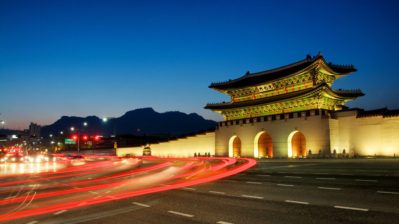
Fondée il y a deux mille ans par le royaume Baekje, l'un des Trois Royaumes de Corée, Séoul est pendant plus de cinq cents ans la capitale du royaume de Joseon. À la fin du XIXe siècle, rompant avec une longue tradition d'isolement, Séoul s'ouvre aux étrangers et notamment aux États-Unis : elle est la première ville d'Asie de l'Est à avoir l'électricité, l'eau courante, le téléphone et un réseau de tramway. Occupée par le Japon de 1910 à 1945 et rebaptisée Gyeongseong, la ville devient la capitale de la République de Corée lors de sa proclamation en 1948. Elle sera gravement endommagée lors des conflits de la Guerre de Corée, dont la bataille de Séoul fut l'un des évènements majeurs : le palais de Gyeongbokgung et sa grande porte sont notamment incendiés. Reconstruite dans les années 1960 et 1970 avec l'aide des États-Unis, elle connaît une forte industrialisation et devient le visage d'une Corée du Sud en voie de modernisation. Depuis les années 1990, Séoul a vu sa population croître de manière importante, notamment grâce à l'afflux de migrants d'Asie du Sud-Est.
Siège des plus grandes entreprises coréennes (les chaebol), dont Samsung, LG et Hyundai, Séoul est considérée comme une ville globale. Son niveau de vie très élevé et son PIB - le quatrième au monde pour une aire urbaine après Tokyo, New York et Los Angeles - en font l'un des principaux centres économiques au monde. Le quartier branché de Gangnam et la Digital Media City concentrent des entreprises dans les nouvelles technologies. La ville compte de nombreux bâtiments à l'architecture futuriste, comme le Dongdaemun Design Plaza et la Lotte Super Tower 123, qui atteint les 555 mètres de hauteur en 2016 et dépasse la N Seoul Tower. Symbole de son rayonnement, Séoul a organisé plusieurs grands évènements internationaux, dont les Jeux asiatiques de 1986, les Jeux olympiques d'été de 1988, la Coupe du monde de football de 2002 et le Sommet du G20 de novembre 2010.
Importante destination touristique, Séoul compte trois monuments classés au patrimoine mondial de l'UNESCO : le palais de Changdeokgung, le sanctuaire de Jongmyo et plusieurs tombes royales de la dynastie Joseon. En raison de sa forte densité de population, plus de trois millions de véhicules y sont comptabilisés, ce qui entraîne des embouteillages quotidiens, même au-delà de minuit. Enfin, en tant que cœur culturel du pays, Séoul est le berceau de la K-pop et de la diffusion de la culture coréenne à travers le monde (hallyu).
Seul[2] (anche Seoul,[3][4][5] pronuncia: Soul; in coreano 서울특별시, Seoul Teukbyeolsi ascolta[?·info]; vecchi nomi Gyeongseong, Hanyang, come nome breve 서울, Seoul, pronuncia /sʌ.ul/) è la capitale della Corea del Sud.
Situata nel nord-ovest del Paese, poco più a sud della zona demilitarizzata coreana, sul fiume Han, la città è il centro politico, culturale, sociale ed economico più importante dello Stato. Sede delle multinazionali che operano nel Paese, come capitale della Corea del Sud rappresenta una delle più forti economie mondiali ed è il simbolo visibile di quello che viene chiamato il "miracolo del fiume Han", riferito agli enormi progressi nel campo dell'economia sudcoreana negli ultimi decenni.
Secondo i dati del servizio demografico ONU[6] l'area urbana di Seul contava 9,7 milioni di abitanti nel 2007, occupando il ventiduesimo posto nella classifica delle città più popolose. I dati cambiano notevolmente se si prendono in considerazione l'area metropolitana di Seul, tra cui il maggiore porto, Incheon, e il più grande centro residenziale, Seongnam, con i quali l'agglomerato urbano arriva fino a venticinque milioni di abitanti. L'alta densità abitativa le ha permesso di diventare una delle città più "cablate" dell'economia informatica globale. Il traffico intenso e l'inquinamento industriale hanno spinto il governo metropolitano a prendere severi provvedimenti di natura ecologica, soprattutto per quanto riguarda la lotta contro lo smog e l'inquinamento idrico. A seguito di tali misure la situazione è migliorata, ma resta problematica.
Seúl (hangul: 서울, RR: Seoul, MR: Sŏul)?, pronunciado: [sʌ.ul](![]() escuchar), oficialmente Ciudad Especial de Seúl (hangul: 서울특별시, RR: Seoul-teukbyeolsi, MR: Sŏul-t'ŭkpyŏlshi)?, es la capital de Corea del Sur desde la creación de esta república en 1948, la capital histórica de Corea desde hace más de 600 años y la ciudad más poblada de la península de Corea.
escuchar), oficialmente Ciudad Especial de Seúl (hangul: 서울특별시, RR: Seoul-teukbyeolsi, MR: Sŏul-t'ŭkpyŏlshi)?, es la capital de Corea del Sur desde la creación de esta república en 1948, la capital histórica de Corea desde hace más de 600 años y la ciudad más poblada de la península de Corea.
Situada en el noroeste del país, a unos 50 kilómetros de la zona desmilitarizada que separa las dos Coreas, forma una unidad administrativa propia dentro del Estado. Está atravesada por el río Han.
Hoy en día, Seúl es considerada una ciudad global, resultado de una explosión de crecimiento económico conocido como el Milagro del río Han, que transformó las cenizas producidas por los bombardeos de la Guerra de Corea en la cuarta economía metropolitana del mundo con un PIB de 773 900 millones de dólares estadounidenses, solo por detrás de Tokio, Nueva York y Los Ángeles.
Con unos 10 millones de habitantes en la ciudad propiamente dicha, y 24,5 millones en toda el área metropolitana, que incluye el puerto de Incheon y la provincia de Gyeonggi, es la cuarta área metropolitana más grande del mundo.
En 2012, las Naciones Unidas situaron la calidad de vida de Seúl por encima de ciudades como Nueva York, Londres o Melbourne, y por debajo de Tokio o París.
Сеу́л (кор. 서울 [sʰʌ.ul], Соуль — букв.: «столица») — город, столица Республики Корея. Образует единственный в стране город особого подчинения, разделённый на 25 самоуправляемых районов. Официальное название города — Город особого подчинения Сеул (кор. 서울특별시 Соуль-тхыкпёльси)
Население — 10,1 млн человек (2015), или 19,5 % населения страны. Образует агломерацию Сеул-Инчхон с населением 23,5 млн человек (2015), четвёртую по величине в мире. Расположен на северо-западе Республики Корея вблизи Жёлтого моря, на равнине в окружении гор, на берегах реки Ханган, в 24 км от границы с КНДР.
Главный политический, экономический и культурный центр Республики Корея. Один из ведущих финансовых центров Восточной Азии.
С 1394 года под названием Ханян — столица Кореи, с 1948 года под названием Сеул — столица Республики Корея. Во время Корейской войны город был сильно разрушен. Сохранились остатки крепостной стены с воротами, восстановлен дворцовый комплекс Кёнбоккун XIV века. Имеются объекты Всемирного наследия ЮНЕСКО.

Suwon ist die größte Stadt und Hauptstadt der Provinz Gyeonggi-do in Südkorea. Sie liegt 48 km südlich von Seoul und ist an deren U-Bahn-Netz mit der Linie 1 angeschlossen. Während der Fußball-Weltmeisterschaft 2002 fanden vier Spiele im am 13. Mai 2001 eröffneten Suwon-World-Cup-Stadion statt.
Samsung Electronics hat seinen Hauptsitz in Suwon.
水原市(朝鮮語:수원시/水原市 Suwon si */?),韩国京畿道首府,地理位置东经127度,北纬37度,大約在首爾以南34公里(21英里),面积121平方公里,人口超118万。
1794年-1796年建成的水原华城是联合国教科文组织世界文化遗产之一。[3]
水原的主要职业球队有韩国职棒联赛KT巫师[4]、韩国职业足球经典联赛水原三星蓝翼[5]、韩国职业足球挑战联赛水原FC[6]。
水原市(スウォンし、韓国語:수원시)は、大韓民国北西部の都市。京畿道の道庁所在地。
ソウル特別市から南35kmに位置する、首都圏南部の中核都市。京畿道庁所在地。中心市街地は、ユネスコの世界遺産に登録されている「華城」の城壁に取り囲まれている城郭都市。名物は水原カルビ(牛カルビの焼肉)。サッカーの水原三星ブルーウィングスも知られる。大韓民国の地方自治法第175条に基づいて特例が適用される特定市に指定されている。
韓国では一般に人口100万人を超える都市は広域市となり道から独立するが、水原市は未だ広域市となっていない。
Suwon[a] (Hangul: 수원; Hanja: 水原, Korean pronunciation: [su.wʌn]) is the capital and largest metropolis of Gyeonggi-do, South Korea's most populous province which surrounds Seoul, the national capital. Suwon lies about 30 kilometres (19 miles) south of Seoul. It is traditionally known as "The City of Filial Piety". With a population close to 1.2 million, it is larger than Ulsan, although it is not governed as a metropolitan city.
Suwon has existed in various forms throughout Korea's history, growing from a small settlement to become a major industrial and cultural center. It is the only remaining completely walled city in South Korea. The city walls are one of the more popular tourist destinations in Gyeonggi Province. Samsung Electronics R&D center and headquarters are in Suwon. The city is served by two motorways, the national railway network, and the Seoul Metropolitan Subway. Suwon is a major educational center, home to 11 universities.[3]
Suwon is home to football club Suwon Samsung Bluewings, which have won the K League on four occasions[4] and AFC Champions League twice. The KT Wiz of the Korea Baseball Organization also plays in Suwon.
Suwon (hangeul : 수원시 prononciation en coréen : /su.wʌn/) est la capitale et la plus grande ville de la province de Gyeonggi en Corée du Sud. Suwon est située environ 30 km au sud de Séoul, sur la ligne ferroviaire nommée Gyeongbu. Certains l'appellent la ville du football coréen, à cause du club Suwon Samsung Bluewings FC, qui est celui qui a le plus de fans en Corée du Sud. Elle est également appelée Samsung City, du fait du nombre important d'employés de Samsung Electronics – environ 40 000 – y vivant et travaillant1. Sa population s'élevait à 1 105 953 habitants au recensement de 2005. La ville est connue pour sa forteresse de Hwaseong, classée au Patrimoine culturel mondial de l’UNESCO en 19972.
Suwon (수원시?, 水原市?, Suwon-siLR) è il capoluogo e la più grande città della provincia di Gyeonggi nella Corea del Sud. Con una popolazione di poco superiore al milione di abitanti è localizzata circa 30 km a sud di Seul. Suwon è famosa per essere l'ultima rimasta delle città fortificate della Corea, e per questo il suo ruolo turistico è molto apprezzato. È inoltre un rinomato centro universitario, con 14 istituti e diversi campus secondari delle università della capitale.
Suwon, oficialmente Ciudad de Suwon (en coreano, 수원시, Suwon-si), es la ciudad capital en la provincia de Gyeonggi al norte de la república de Corea del Sur. Está ubicada al sur de Seúl a unos 30 km y su área es de 121.08 km² y su población total es de 1.098.000. Se conoce tradicionalmente como "La Ciudad de la piedad filial".
Суво́н (кор. 수원시?, 水原市?; Suwon-si) — столица и крупнейший город провинции Кёнгидо Республики Корея. Население ок. 1,2 млн человек. Сувон расположен на 30 километров южнее Сеула. Иногда город называют столицей корейского футбола — в нём располагается самая известная корейская футбольная команда Сувон Самсунг Блюуингз. В городе расположен исследовательский центр ведущих подразделений компании Самсунг Электроникс.

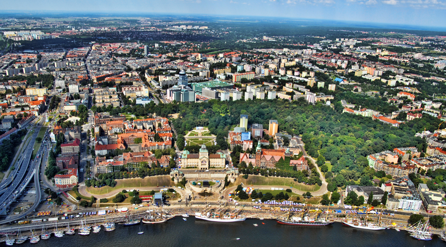
Stettin (polnisch Szczecinⓘ/? [ˈʂt͡ʂɛt͡ɕin]) ist die Hauptstadt der polnischen Woiwodschaft Westpommern. Die kreisfreie Großstadt mit knapp 400.000 Einwohnern ist die siebtgrößte Stadt Polens. Sie bildet den Schwerpunkt des deutsch-polnischen Ballungsraums Stettin mit etwa 780.000 Einwohnern, der zu einer europäischen Metropolregion mit rund einer Million Einwohnern entwickelt werden soll.[4][5]
Die Universitätsstadt ist mit fünf staatlichen Universitäten, der Universität Stettin, der Westpommersche Technische Universität Stettin, Pommersche Medizinische Universität Stettin, Maritime Technische Universität und Akademie der Kunst, ein bedeutender Forschungs- und Hochschulstandort. Daneben sind in Stettin zahlreiche Berufsschulen, Kunstakademien und eine private Business School angesiedelt.
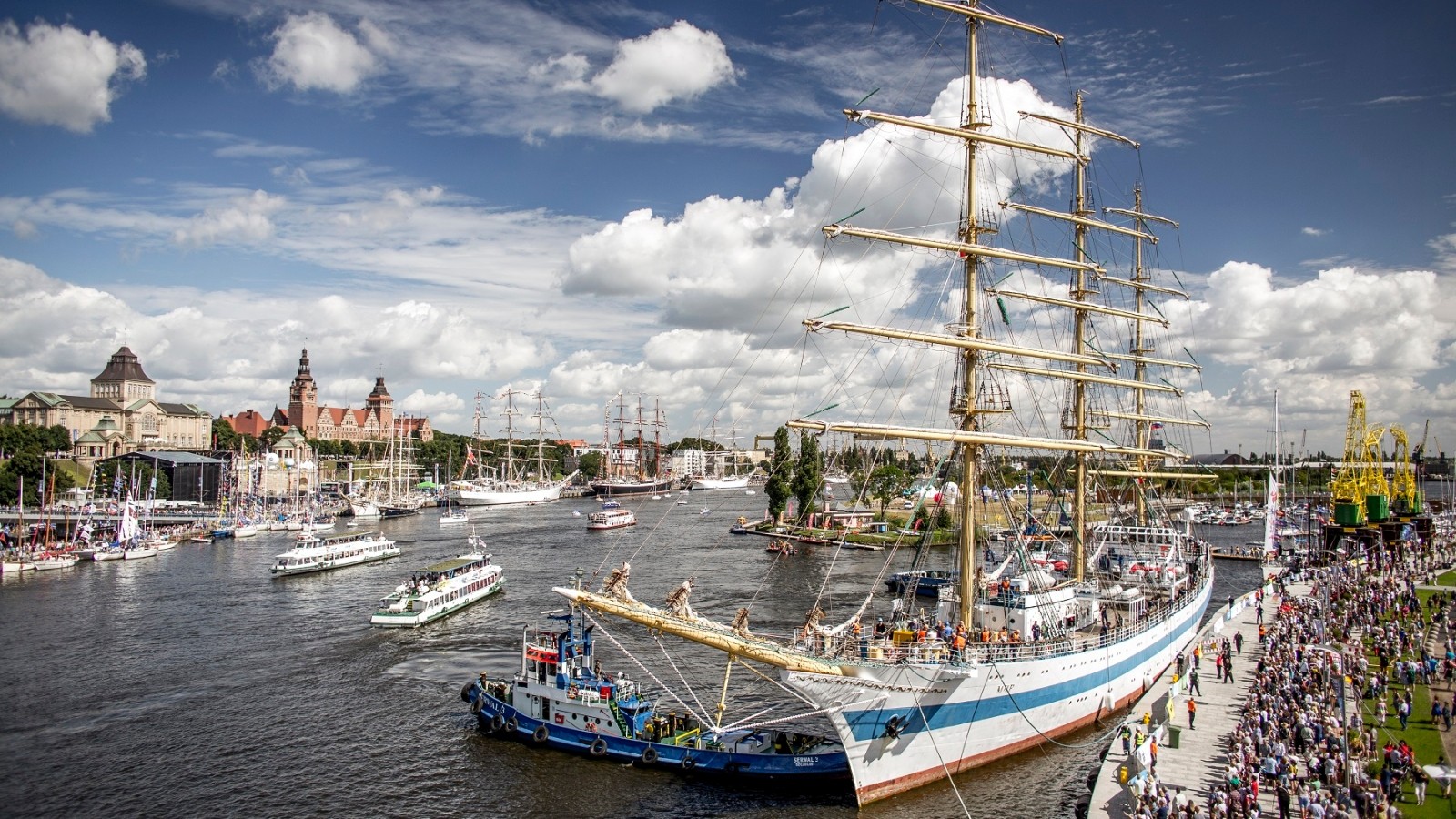
Historisch, kulturell und touristisch bedeutsam sind als Wahrzeichen Stettins unter anderem das Greifenschloss und die Jakobskathedrale in der Altstadt, die Philharmonie sowie die Hakenterrasse mit dem Nationalmuseum. Bekanntester Sportverein der Stadt ist der Fußballclub Pogoń Stettin, große Bedeutung besitzt darüber hinaus der Rudersport. Bis 1945 gehörte Stettin zu Deutschland.
Eurovision Song Contest,ESC
History
Hansestadt
International cities
*European Capital of Culture
Olympic Summer Games
Sweden
Silk road
Umwelthauptstadt Europas
 World Heritage
 Important port
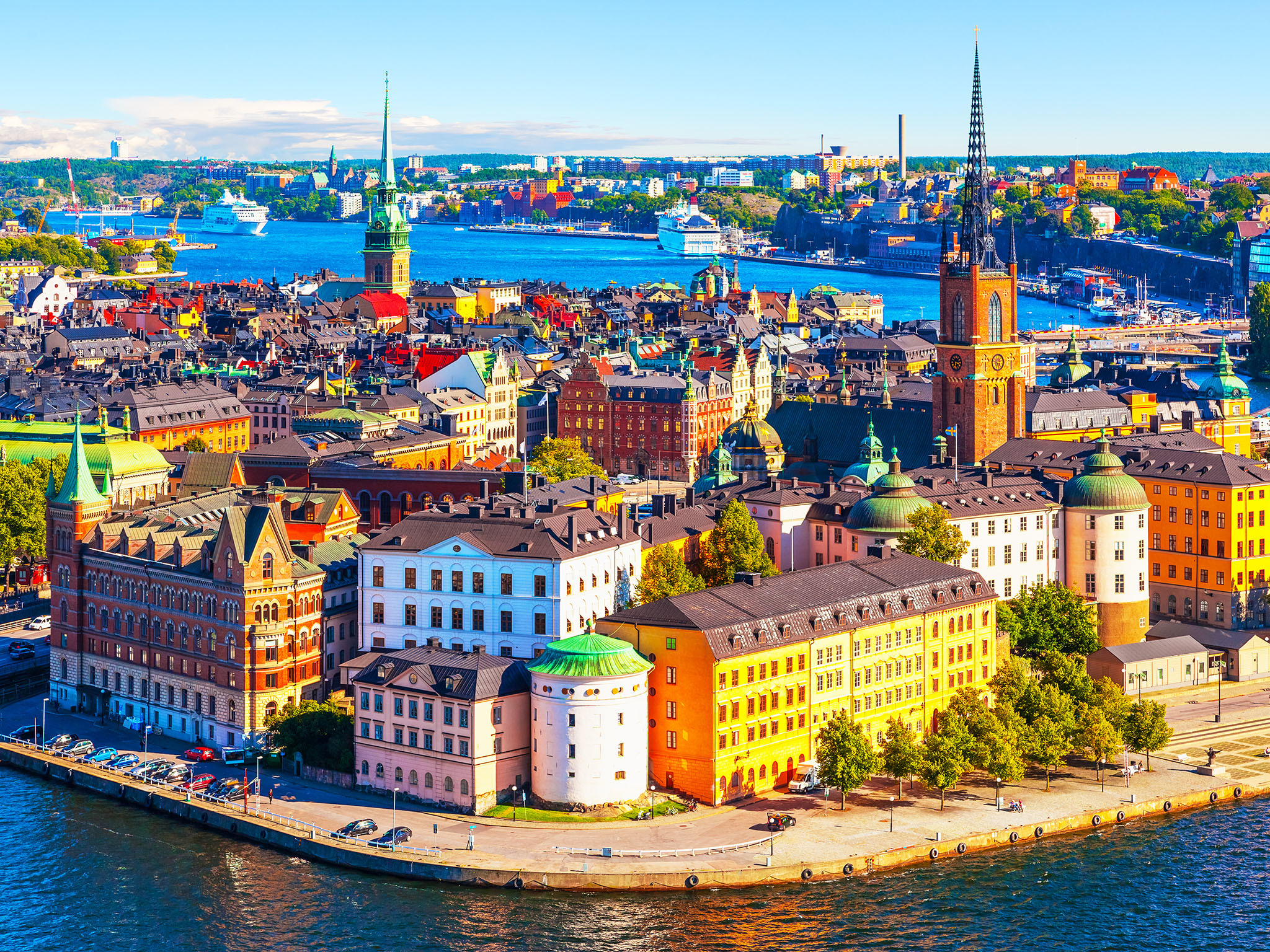
Stockholm [stɔkːɔlm]?/i (vom altschwedischen stokker, entsprechend schwedisch stock „Baumstamm, Warenbestand“ und holmber, schwedisch holme „kleine Insel“) ist die Hauptstadt Schwedens und mit 935.619 (Gemeinde Stockholm), 1,4 Millionen (tätort[2] Stockholm) beziehungsweise 2,1 Millionen Einwohnern (Groß-Stockholm) die größte Stadt in Skandinavien.[1][3] Sie hat eine mehr als sieben Jahrhunderte zurückreichende Besiedlungsgeschichte und ist seit 1643 die Residenz des Königs.
Die Stadt ist sowohl Sitz des schwedischen Parlamentes als auch der schwedischen Regierung. Sie ist ebenso das kulturelle Zentrum des Landes und Bischofssitz.
Stockholm ist eine der nördlichsten Hauptstädte der Welt und auch eine der Spannendsten. Traditionell und auch offen für alles Neue, so präsentiert sich die Stadt mit ihrem historischen Bauten und der modernen Architektur. Die Stockholmer selbst sind tief verwurzelt mit ihrem Land, gleichzeitig unendlich gastfreundlich und charmant. Nicht umsonst ist Stockholm die Heimatstadt des Nobelpreises. Wissenschaft, Kunst und Kultur werden in der Stadt an den Schären groß geschrieben. 100 Kunstgalerien und 70 Museen-davon können sich die Stockholm-Besucher überzeugen. Das musikalische Angebot ist vor allem im Sommer in den vielen Parkanlagen gigantisch. Rasante Feste werden über das ganze Jahr veranstaltet. Aber die
Dienerrennen, die Walpurgisnacht, der Stockholm-Marathon oder das Mit-Sommerfest: In Schwedens Hauptstadt gibt es immer einen Grund zum Feiern. Die Monarchie ist in Stockholm allgegenwärtig.(Quelle: http://www.mytraveltips.de/schweden/stockholm/)
斯德哥尔摩(瑞典语:Stockholm, 发音 帮助·信息,当地华人有时称其为斯京),瑞典首都及最大城市,亦是斯德哥尔摩省首府。瑞典王国政府、国会以及瑞典王室的官方宫殿都设在斯德哥尔摩。它位于瑞典的东海岸,濒波罗的海,梅拉伦湖入海处,风景秀丽,是著名的旅游胜地。市区分布在14座岛屿和一个半岛上,70余座桥梁将这些岛屿联为一体,因此享有“北方威尼斯”的美誉。斯德哥尔摩市区为大斯德哥尔摩的一部分。
从13世纪起,斯德哥尔摩就已经成为瑞典的政治、文化、经济和交通中心。斯德哥尔摩由于免受战争的破坏而保存良好,现在共有100多座博物馆和名胜,包括历史、民族、自然、美术等各个方面。斯德哥尔摩也是一个高科技的城市,拥有众多大学,工业发达。
斯德哥尔摩是阿尔弗雷德·诺贝尔的故乡。从1901年开始,每年12月10日诺贝尔逝世纪念日,斯德哥尔摩音乐厅举行隆重仪式,瑞典国王亲自给获诺贝尔奖者授奖,并在市政厅举行晚宴。
斯德哥尔摩(Stockholm),是瑞典的首都和第一大城市,瑞典政治、经济、文化、交通中心和主要港口,也是瑞典国家政府、国会以及皇室的官方宫殿都所在地,世界著名的国际大都市。
斯德哥尔摩位于瑞典的东海岸,濒波罗的海,梅拉伦湖入海处,风景秀丽,是著名的旅游胜地。市区分布在14座岛屿和一个半岛上,70余座桥梁将这些岛屿联为一体,因此享有“北方威尼斯”的美誉。斯德哥尔摩市区为大斯德哥尔摩的一部分。
斯德哥尔摩城市名称直译过来为木头岛,建于13世纪,1436年起斯德哥尔摩就已经成为瑞典的政治、文化、经济和交通中心。
斯德哥尔摩由于免受战争的破坏而保存良好,现在共有100多座博物馆和名胜,包括历史、民族、自然、美术等各个方面。斯德哥尔摩也是一个高科技的城市,拥有众多大学,工业发达。斯德哥尔摩也是瑞典的金融中心,瑞典主要的银行的总部都在这里。
斯德哥尔摩是阿尔弗雷德·诺贝尔的故乡。从1901年开始,每年12月10日诺贝尔逝世纪念日,斯德哥尔摩音乐厅举行隆重仪式,瑞典国王亲自给获诺贝尔奖者授奖,并在市政厅举行晚宴。
Stockholm[a] is the capital of Sweden and the most populous city in the Nordic countries;[9][b] 952,058 people live in the municipality,[10] approximately 1.5 million in the urban area,[5] and 2.3 million in the metropolitan area.[11] The city stretches across fourteen islands where Lake Mälaren flows into the Baltic Sea. Just outside the city and along the coast is the island chain of the Stockholm archipelago. The area has been settled since the Stone Age, in the 6th millennium BC, and was founded as a city in 1252 by Swedish statesman Birger Jarl. It is also the capital of Stockholm County. Stockholm is the only capital in the world with a national urban park.[12]
Stockholm is the cultural, media, political, and economic centre of Sweden. The Stockholm region alone accounts for over a third of the country's GDP,[13] and is among the top 10 regions in Europe by GDP per capita.[14] It is an important global city,[15][16] and the main centre for corporate headquarters in the Nordic region.[17] The city is home to some of Europe's top ranking universities, such as the Stockholm School of Economics, Karolinska Institute and Royal Institute of Technology (KTH).[18][19] It hosts the annual Nobel Prize ceremonies and banquet at the Stockholm Concert Hall and Stockholm City Hall. One of the city's most prized museums, the Vasa Museum, is the most visited non-art museum in Scandinavia.[20][21] The Stockholm metro, opened in 1950, is well known for the decor of its stations; it has been called the longest art gallery in the world.[22][23][24] Sweden's national football arena is located north of the city centre, in Solna. Ericsson Globe, the national indoor arena, is in the southern part of the city. The city was the host of the 1912 Summer Olympics, and hosted the equestrian portion of the 1956 Summer Olympics otherwise held in Melbourne, Victoria, Australia.
Stockholm is the seat of the Swedish government and most of its agencies,[25] including the highest courts in the judiciary,[26][27] and the official residencies of the Swedish monarch and the Prime Minister. The government has its seat in the Rosenbad building, the Riksdag (Swedish parliament) is seated in the Parliament House, and the Prime Minister's residence is adjacent at the Sager House.[28][29][30] The Stockholm Palace is the official residence and principal workplace of the Swedish monarch, while the Drottningholm Palace, a World Heritage Site on the outskirts of Stockholm, serves as the Royal Family's private residence.[31][32]
Stockholm (prononcé en suédois [²stɔkː(h)ɔlm] Écouter) est la capitale et la plus grande ville de Suède. Elle est le siège du gouvernement et du parlement suédois ainsi que le lieu de résidence officielle du roi Carl XVI Gustav.
La ville de Stockholm (Stockholms stad) ou, plus officiellement, la commune de Stockholm (Stockholms kommun) est, avec ses 1 538 517 habitants1, la plus grande des 290 municipalités suédoises. Le Grand Stockholm, qui couvre la majeure partie du Comté de Stockholm, a, lui, une population de 2 063 945 habitants1 sur une superficie de près de 6 600 km2.
Située au bord de la mer Baltique, la ville est construite en partie sur plusieurs îles, à l'embouchure du lac Mälar, ce qui lui a valu, à l'instar d'autres cités européennes, son surnom de Venise du Nord (par ailleurs aussi donné à Bruges (Belgique), à Saint-Pétersbourg (Russie), et à Amsterdam (Pays-Bas).
Stoccolma (AFI: /stokˈkolma/[2]; in svedese Stockholm, pronunciato ascolta[?·info] [ˈstɔkːˈhɔlm, ˈstɔkːˈɔlm, ˈstɔkːɔlm];[3] 952.058 ab.)[4] è la capitale della Svezia, capoluogo della contea di Stoccolma. Posta nella parte orientale del paese, sul mar Baltico, è sede di governo e parlamento, oltre che luogo di residenza del capo dello stato, il re Carlo Gustavo XVI. Maggiore città della Svezia e della Scandinavia, è il centro di riferimento economico e culturale della Svezia.
Anche l'area metropolitana (Storstockholm) è la più grande della nazione, contando 2.213.528 abitanti.[4][5] Amministrativamente la città è divisa in 26 comuni. Il centro e la gran parte dei sobborghi ad esso più vicini sono compresi nel comune di Stoccolma.
Estocolmo ( [stɔkːɔlm] (?·i) en sueco, Stockholm) es la capital y ciudad más grande de Suecia.
La ciudad de Estocolmo es administrativamente un municipio de la provincia homónima, incluye el área metropolitana. Estocolmo ha sido nombrada por la GaWC como una ciudad global de «clase alfa»1 en el índice global de las ciudades 2008, ocupa el puesto 24 en el mundo, el número 8 en Europa y el número 1 de toda Escandinavia.
Estocolmo es a menudo conocida por su belleza, sus edificios y arquitectura, su agua limpia y abierta y sus numerosos parques, jardines y canales. Forma parte del grupo de ciudades conocidas vulgarmente como las «Venecias del Norte». Como capital del Estado, Estocolmo es la sede del Gobierno, el Parlamento (Riksdag), el Tribunal Supremo de Justicia (Hōgsta Domstolen). Alberga también el Palacio de Drottningholm, residencia oficial y despacho del jefe de Estado, el rey Carlos XVI Gustavo de Suecia. La ciudad fue premiada con el título Capital Verde Europea 2010.
 Arizona-AZ


Skopje (mazedonisch Скопје, albanisch Shkupi/Shkup, türkisch Üsküp) ist die Hauptstadt Mazedoniens und mit über 540.000 Einwohnern zugleich die größte Stadt des Landes. Etwa ein Viertel der Bevölkerung Mazedoniens lebt in der Großstadt. Skopje weist eine mehr als zwei Jahrtausende zurückreichende Besiedlungsgeschichte auf und gehört somit zu den ältesten noch bestehenden Städten des Landes.
Die Stadt am Vardar ist sowohl Sitz des Parlamentes als auch der Regierung. Sie ist ebenso das kulturelle und wirtschaftliche Zentrum des Landes, orthodoxer Bischofssitz und Sitz eines Großmuftis.
斯科普里(马其顿语:Скопје,罗马化:Skopje)是马其顿共和国的首都,也是马其顿最大的都市,马其顿全国总人口的三分之一居住在斯科普里。斯科普里也是马其顿的政治、文化、经济、学术的中心都市。斯科普里在古罗马时期的名称是斯库皮(Scupi)。斯科普里附近地区自约公元前4000年以来就有人居住。在今日斯科普里市中心的斯科普里城堡附近发现了新石器时代的集落遗迹。1世纪前夕,集落被罗马人攻克,成为罗马军队的野营地[2][3]。
罗马帝国在395年分为东罗马帝国和西罗马帝国,斯库皮由首都位于君士坦丁堡的东罗马帝国统治。在中世纪的早期,拜占庭和保加利亚第一帝国争夺巴尔干地区的霸权。972年至992年期间,斯科普里是保加利亚第一帝国的首都。1282年开始,斯科普里由塞尔维亚统治。1346年,塞尔维亚帝国将斯科普里设为首都。1392年,斯科普里被奥斯曼帝国征服,奥斯曼人称斯科普里为于斯屈普(Üsküp)。斯科普里在此之后被奥斯曼统治超过500年,是于斯屈普帕夏桑扎克的首府。之后又是科索沃州(Vilayet of Kosovo)的首府。在这一期间,市内建造了许多著名的东方样式的建筑物。
在1912年巴尔干战争期间,斯科普里被塞尔维亚王国征服,第一次世界大战之后,斯科普里成为新建国家塞尔维亚人、克罗地亚人和斯洛文尼亚人王国(后成为南斯拉夫王国)的一部分。第二次世界大战时期,斯科普里被轴心国国家保加利亚王国军队占领。1944年,成为南斯拉夫社会主义联邦共和国的加盟国马其顿社会主义共和国的首都。斯科普里在第二次世界大战之后得到了急速的开发。但因1963年发生了地震,其发展一时停滞。1991年,斯科普里成为自南斯拉夫独立的马其顿共和国的首都。
スコピエ(マケドニア語: Скопје/Skopje [ˈskɔpjɛ] (![]() 音声ファイル))はマケドニア共和国の首都。
音声ファイル))はマケドニア共和国の首都。
マケドニア共和国の全人口の3分の1が居住する最大の都市であり、同国の政治、文化、経済、学術の中心都市である。古代ローマ期にはスクウピ (en) の名で知られていた。スコピエ周辺は紀元前4000年頃以来人が居住し、新石器時代の集落跡が現代のスコピエ中心部を見下ろすケール城塞(スコピエ城塞)周辺で発見されている。1世紀直前、集落はローマ人によって押さえられ軍の野営地となった。[1][2]
ローマ帝国が395年に東西に分かれるとスクウピはコンスタンティノープルのビザンティンの支配下に入った。中世初期の多くの期間ビザンティンと第一次ブルガリア帝国の間でその覇権が争われ、972年から992年にかけてスコピエには第一次ブルガリア帝国の首都が置かれた。1282年からは町はセルビアの支配下に入り、1346年にセルビア帝国の首都が置かれている。1392年、スコピエの町はオスマン帝国に征服されオスマンの人々は町をユスキュプ(Üsküp)と呼んでいた。以来、約500年以上にわたりオスマンの支配下にありユスキュプ・パシャサンジャクの首都で後にコソボ州 (en) の首都であった。この期間に現在でも市内に残る著名なオリエンタル様式の建築物の多くが造られている。
1912年に町はバルカン戦争の期間セルビア王国によって征服され、第一次世界大戦後、新たに形成された後のユーゴスラビア王国となるスロベニア人・クロアチア人・セルビア人国の一部となる。第二次世界大戦時には町は枢軸国の一部であったブルガリア王国の軍によって占領された。1944年にはユーゴスラビア社会主義連邦共和国の構成国であるマケドニア社会主義共和国の首都となる。スコピエは第二次世界大戦後に急速に開発されるが、1963年に発生した1963年スコピエ地震によりその発展が一時滞る。1991年にはユーゴスラビアから独立しマケドニア共和国の首都となっている。
スコピエはヴァルダル川の上流部にあり、ベオグラードとアテネのバルカン半島の南北を結ぶ回廊に位置しほぼ中間にあたる。金属加工や化学、木材、織物、皮革、印刷産業などの中心でスコピエの産業発展は、貿易、物流、金融部門だけでなく、文化やスポーツの分野においても重点を置かれた開発が伴っている。最新の2002年の公式な国勢調査によればスコピエの人口は506,926人で、2つの非公式な直近の調査によれば668,518人[3] または 491,000人である。Skopje (/ˈskɒpji, -jeɪ/, US also /ˈskoʊp-/;[2] Macedonian: Скопје [ˈskɔpjɛ] (![]() listen)) is the capital and largest city of the Republic of Macedonia. It is the country's political, cultural, economic, and academic center. It was known in the Roman period under the name Scupi.
listen)) is the capital and largest city of the Republic of Macedonia. It is the country's political, cultural, economic, and academic center. It was known in the Roman period under the name Scupi.
The territory of Skopje has been inhabited since at least 4000 BC; remains of Neolithic settlements have been found within the old Kale Fortress that overlooks the modern city centre. Scupi became the capital of Dardania in the second century BC. On the eve of the 1st century AD, the settlement was seized by the Romans and became a military camp.[3][4] When the Roman Empire was divided into eastern and western halves in 395 AD, Scupi came under Byzantine rule from Constantinople. During much of the early medieval period, the town was contested between the Byzantines and the Bulgarian Empire, whose capital it was between 972 and 992.
From 1282, the town was part of the Serbian Empire and acted as its capital city from 1346 to 1371. In 1392, the city was conquered by the Ottoman Turks who called the town Üsküp. The town stayed under Turkish control for over 500 years, serving as the capital of pashasanjak of Üsküb and later the Vilayet of Kosovo. At that time the city was famous for its oriental architecture[citation needed]. In 1912, it was annexed by the Kingdom of Serbia during the Balkan Wars[5] and after the First World War the city became part of the newly formed Kingdom of Serbs, Croats and Slovenes (Kingdom of Yugoslavia) becoming the capital of the Vardarska banovina. In the Second World War the city was conquered by the Bulgarian Army, which was part of the Axis powers. In 1944, it became the capital city of Democratic Macedonia (later Socialist Republic of Macedonia), which was a federal state, part of Democratic Federal Yugoslavia (later Socialist Federal Republic of Yugoslavia). The city developed rapidly after World War II, but this trend was interrupted in 1963 when it was hit by a disastrous earthquake. In 1991, it became the capital city of an independent Macedonia.
Skopje is located on the upper course of the Vardar River, and is located on a major north-south Balkan route between Belgrade and Athens. It is a center for metal-processing, chemical, timber, textile, leather, and printing industries. Industrial development of the city has been accompanied by development of the trade, logistics, and banking sectors, as well as an emphasis on the fields of transportation, culture and sport. According to the last official count from 2002, Skopje has a population of 506,926 inhabitants; according to official estimates, the city has a population of 544,086 inhabitants, as of June 30, 2015.[6]
Skopje (en macédonien Скопје, prononcé [ˈskɔ.pjɛ] (skopiè) Écouter, Scopie en français, en turc Üsküp) est la capitale et la plus grande ville de la république de Macédoine. Elle compte aujourd'hui un peu plus de 500 000 habitants, soit le tiers de la population totale du pays, dont une forte minorité d'Albanais et des communautés turque et rom. Seule métropole macédonienne, elle concentre la majeure partie des fonctions administratives, économiques et culturelles du pays. Elle est située sur un important carrefour routier des Balkans, entre l'Égée et le Danube, et l'Adriatique et la mer Noire, et vit principalement de l'industrie métallurgique, agroalimentaire et textile.
Après avoir été le lieu de diverses occupations préhistoriques, Skopje naît véritablement au Ier siècle avec la fondation d'une colonie romaine appelée « Scupi », qui est rattachée à l'Empire romain d'Orient en 395. La ville antique est détruite par un séisme en 518. Reconstruite quelques kilomètres plus loin et fortifiée, elle connaît de nombreuses invasions au cours des Xe et XIe siècles, entrant au Xe siècle dans le Premier Empire bulgare sous Siméon Ier de Bulgarie, pour revenir dans l'Empire byzantin en 1018 après la défaite du dernier tsar bulgare Samuel par le Basileus Basile II et la disparition du Premier Empire bulgare. La domination byzantine s'achève avec la conquête serbe en 1282, et Skopje devient brièvement la capitale de l'Empire serbe en 1346. L’État s'affaiblit toutefois rapidement et la ville est conquise par les Ottomans en 1392.
La ville devient alors majoritairement musulmane et sa fonction commerciale est favorisée par sa situation entre l'Europe centrale et la mer Égée. Au XVIIe siècle, Skopje est l'une des plus grandes villes des Balkans. Mais elle est incendiée en 1689 au cours de la Deuxième Guerre austro-turque et elle périclite par la suite jusqu'au milieu du XIXe siècle. L'ouverture d'une voie ferrée permet une certaine croissance démographique, et Skopje devient chef-lieu du vilayet du Kosovo en 1877.
Elle redevient serbe en 1912, puis est intégrée à la Yougoslavie en 1918. Chef-lieu de la banovine du Vardar, l'une des dix régions du royaume de Yougoslavie, elle devient capitale de la République socialiste de Macédoine après la Seconde Guerre mondiale, puis, naturellement, capitale de la Macédoine ex-Yougoslave lorsque celle-ci devient indépendante en 1991. Tout au long du XXe siècle, la croissance démographique est soutenue et la ville s'industrialise. Cet essor est brièvement interrompu par le tremblement de terre de 1963. La ville est presque entièrement détruite, mais la reconstruction est rapide et s'accompagne d'une forte croissance des investissements.
Les années qui suivent l'indépendance sont difficiles sur le plan économique. Skopje demeure une ville pauvre par comparaison aux villes européennes, bien que les Skopiotes aient un meilleur niveau de vie que le reste des Macédoniens. La ville se caractérise par une architecture variée, comprenant plusieurs témoignages de la présence ottomane ainsi qu'un important ensemble de style moderniste édifié après le séisme de 1963. Le centre-ville est depuis la fin des années 2000 le siège d'une vaste opération d'urbanisme, destinée à lui donner un visage plus monumental et affirmer son statut de capitale nationale.
Skopje (in macedone Скопје, in albanese Shkup) è la capitale e la città più popolosa della Repubblica di Macedonia, con 506.926 abitanti[1].
La Città di Skopje costituisce una speciale area amministrativa nell'ordinamento dello Stato, la Grande Skopje, costituita da dieci comuni.[2] Con più di un quarto della popolazione del Paese, è il centro politico, culturale, economico ed accademico della nazione. Conosciuta al tempo dei romani sotto il nome di Scupi, la città si è sviluppata rapidamente dopo la seconda guerra mondiale, ma questa crescita venne interrotta nel 1963, quando fu colpita da un disastroso terremoto.
Skopje si trova lungo il corso superiore del fiume Vardar e su una delle strade principali dei Balcani tra l'Europa centrale ed Atene. È un centro principale per le industrie metalmeccaniche, chimiche, tessili, di stampa e concerie, ma ha sofferto molti fallimenti dal 1991. Lo sviluppo industriale della città è stato accompagnato dallo sviluppo del commercio e del settore bancario, così come nel campo della cultura e dello sport. Skopje è anche un mercato di prodotti agricoli e zootecnici. L'università risale al 1949, quindi la città è anche un importante centro culturale nell'ambito della Repubblica. Ospita uno dei due aeroporti dello stato.
Skopie1 (en macedonio: Скопје ![]() [ˈskɔpjɛ] (?·i)) es la capital y la mayor ciudad de la República de Macedonia; sus 668 518 habitantes (según el censo de 2006) suponen la cuarta parte de la población del país.2 La ciudad se encuentra en el curso superior del río Vardar, en una de las principales rutas balcánicas entre Belgrado y Atenas. La ciudad se desarrolló rápidamente tras la Segunda Guerra Mundial, pero esta evolución fue interrumpida en 1963 cuando fue sacudida por un fuerte terremoto. Hoy en día es el centro político, económico, cultural y académico, además de ser un importante centro de industrias metalúrgicas, químicas, madereras, textiles, del cuero y de imprenta. El desarrollo industrial ha ido acompañado por un intenso desarrollo interno y externo del comercio y de la banca, así como de actividades culturales y deportivas.
[ˈskɔpjɛ] (?·i)) es la capital y la mayor ciudad de la República de Macedonia; sus 668 518 habitantes (según el censo de 2006) suponen la cuarta parte de la población del país.2 La ciudad se encuentra en el curso superior del río Vardar, en una de las principales rutas balcánicas entre Belgrado y Atenas. La ciudad se desarrolló rápidamente tras la Segunda Guerra Mundial, pero esta evolución fue interrumpida en 1963 cuando fue sacudida por un fuerte terremoto. Hoy en día es el centro político, económico, cultural y académico, además de ser un importante centro de industrias metalúrgicas, químicas, madereras, textiles, del cuero y de imprenta. El desarrollo industrial ha ido acompañado por un intenso desarrollo interno y externo del comercio y de la banca, así como de actividades culturales y deportivas.

斯库台[3](阿尔巴尼亚语:Shkodër)是位于阿尔巴尼亚西北部,斯库台州的都市。临近斯库台湖,是斯库台州的首府,也是阿尔巴尼亚的城市中,最具历史的城市之一。斯库台也是阿尔巴尼亚北部文化及经济的中心。斯库台的人口有95,907人,算上附近地区,斯库台州的人口则有217,375人。是次于爱尔巴桑(中部的工业都市)之后的阿尔巴尼亚第4大都市,距首都地拉那有116公里[4]。
Shkodra (albanisch auch Shkodër) ist eine Stadt im Norden Albaniens. Sie liegt zwischen dem Skutarisee und den Flüssen Kir, Drin und Buna.
Die 2400 Jahre alte Stadt ist seit jeher regionales Verwaltungszentrum. Heute ist Shkodra Amtssitz der Bashkia (Stadtgemeinde) sowie Hauptstadt des Qarks Shkodra. Die Stadt zählt 142.513 Einwohner (Stand: 2011) und ist die fünftgrößte Stadt des Landes.[1]
Shkodra ist traditionell das kulturelle Zentrum Nordalbaniens. Viele Shkodraner Persönlichkeiten aus Kultur, Politik und Gesellschaft waren in der Vergangenheit auch von nationaler Bedeutung. Ihnen verdankt man beispielsweise die ersten Fotografien, die in Albanien geschossen wurden oder künstlerische Werke, welche das albanische Nationalbewusstsein bis in die Gegenwart prägen. Nicht umsonst war die Stadt bis vor einem Jahrhundert eines der kulturellen Zentren Albaniens, wo auch die albanische Nationalbewegung Rilindja (Wiedergeburt) viele Anhänger und Unterstützer hatte. Deswegen gilt das kulturelle und historische Erbe Shkodras als eines der bedeutendsten nicht nur in Albanien selbst, sondern in allen von Albanern bewohnten Gebieten auch in den Nachbarländern.
 Ski vacation
 California-CA


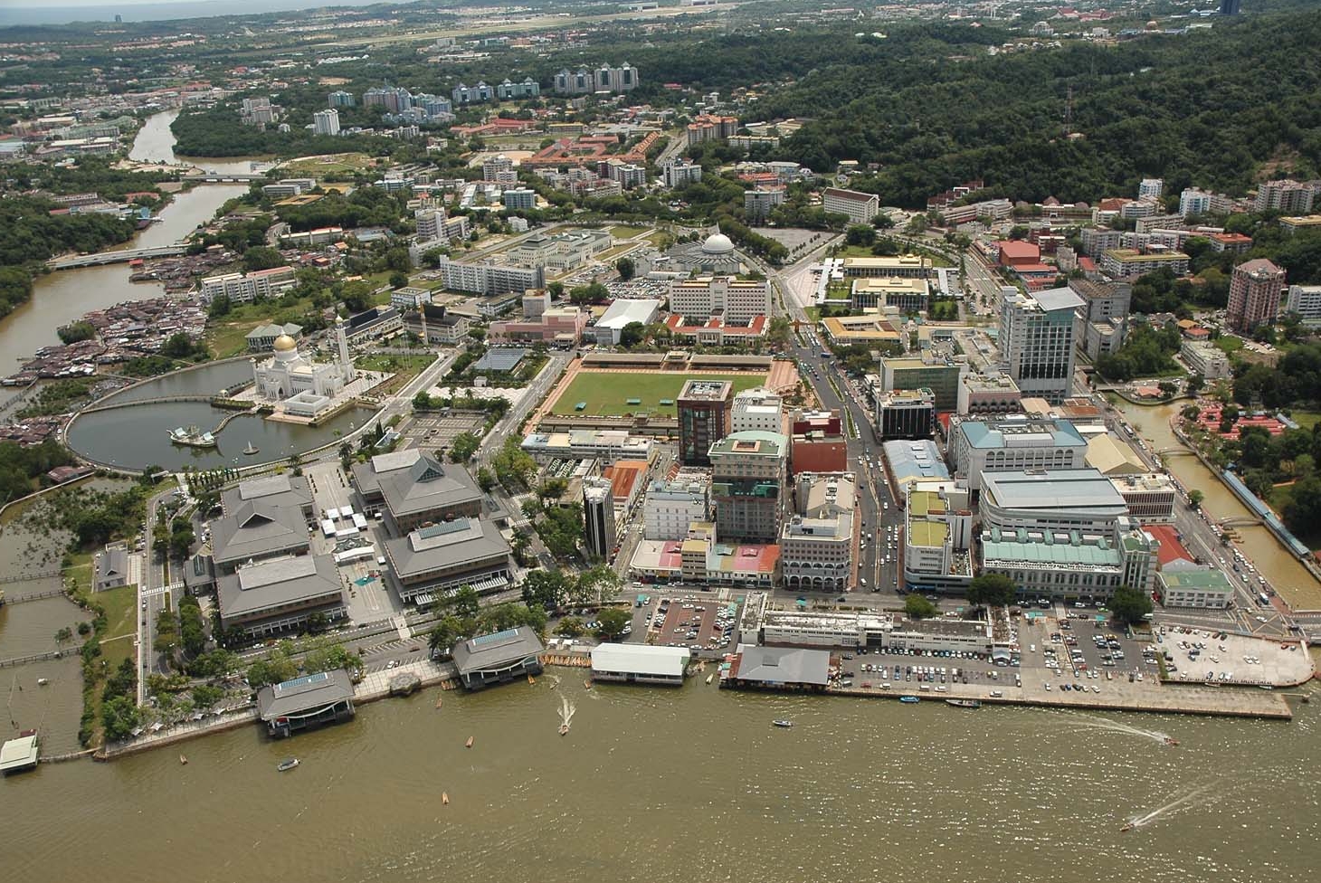
Bandar Seri Begawan ([ˈbandar səˈri baˈɡawan], Jawi: بندر سري بڬاوان, malaiisch für Hafen des verehrten Herrschers, von Persisch Bandar = Hafen und Sanskrit Shri Bhagwan = Verehrter Herrscher, meist nur BSB genannt; bis 1970 Brunei-Stadt) ist die Hauptstadt von Brunei. Sie liegt am Brunei-Fluss, der unweit in die Bucht von Brunei und damit in das Südchinesische Meer mündet.
斯里巴加湾市(马来语:Bandar Seri Begawan,直译:“圣主之城”)是文莱自17世纪起的首都,原名文莱城(Bandar Brunei),1970年10月4日改为现名。2010年统计人口约14万人,位于林梦河注入南海的入海口。地理位置为东经114°55',北纬4°55'。
市内的名胜包括文莱苏丹的宫殿,这座宫殿是世界上最大的宫殿之一。其它名胜有1958年建造的奥马尔·阿里·赛福鼎清真寺以及它附近的文莱水乡。