
漢德百科全書 | 汉德百科全书
 China
China
 Companies

 Architecture
 Transport and traffic
Beijing Shi-BJ
Belarus
Transport and traffic
Beijing Shi-BJ
Belarus
 Berlin
 Brandenburg
 Bremen
China
Germany
France
Gansu Sheng-GS
Hebei Sheng-HE
Heilongjiang Sheng-HL
Henan Sheng-HA
Hubei Sheng-HB
Hunan Sheng-HN
Iran
Italy
Jiangsu Sheng-JS
Jilin Sheng-JL
Kasachstan
Liaoning Sheng-LN
Nei Mongol Zizhiqu-NM
Netherlands
Bremen
China
Germany
France
Gansu Sheng-GS
Hebei Sheng-HE
Heilongjiang Sheng-HL
Henan Sheng-HA
Hubei Sheng-HB
Hunan Sheng-HN
Iran
Italy
Jiangsu Sheng-JS
Jilin Sheng-JL
Kasachstan
Liaoning Sheng-LN
Nei Mongol Zizhiqu-NM
Netherlands
 Lower Saxony
Ningxia Huizu Zizhiqu-NX
Lower Saxony
Ningxia Huizu Zizhiqu-NX
 North Rhine-Westphalia
Poland
Portugal
Russia
North Rhine-Westphalia
Poland
Portugal
Russia
 Saxony
 Schleswig-Holstein
Shaanxi Sheng-SN
Shandong Sheng-SD
Shanxi Sheng-SX
Sichuan Sheng-SC
Spain
Turkey
Turkmenistan
Uzbekistan
United Kingdom
Xinjiang Uygur Zizhiqu-XJ
Zhejiang Sheng-ZJ
Schleswig-Holstein
Shaanxi Sheng-SN
Shandong Sheng-SD
Shanxi Sheng-SX
Sichuan Sheng-SC
Spain
Turkey
Turkmenistan
Uzbekistan
United Kingdom
Xinjiang Uygur Zizhiqu-XJ
Zhejiang Sheng-ZJ
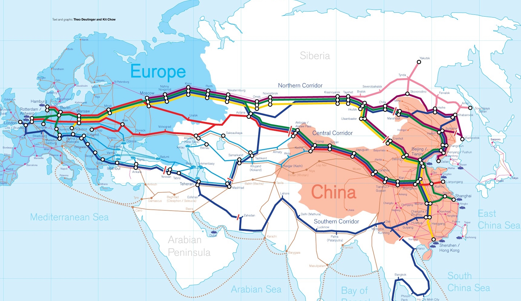
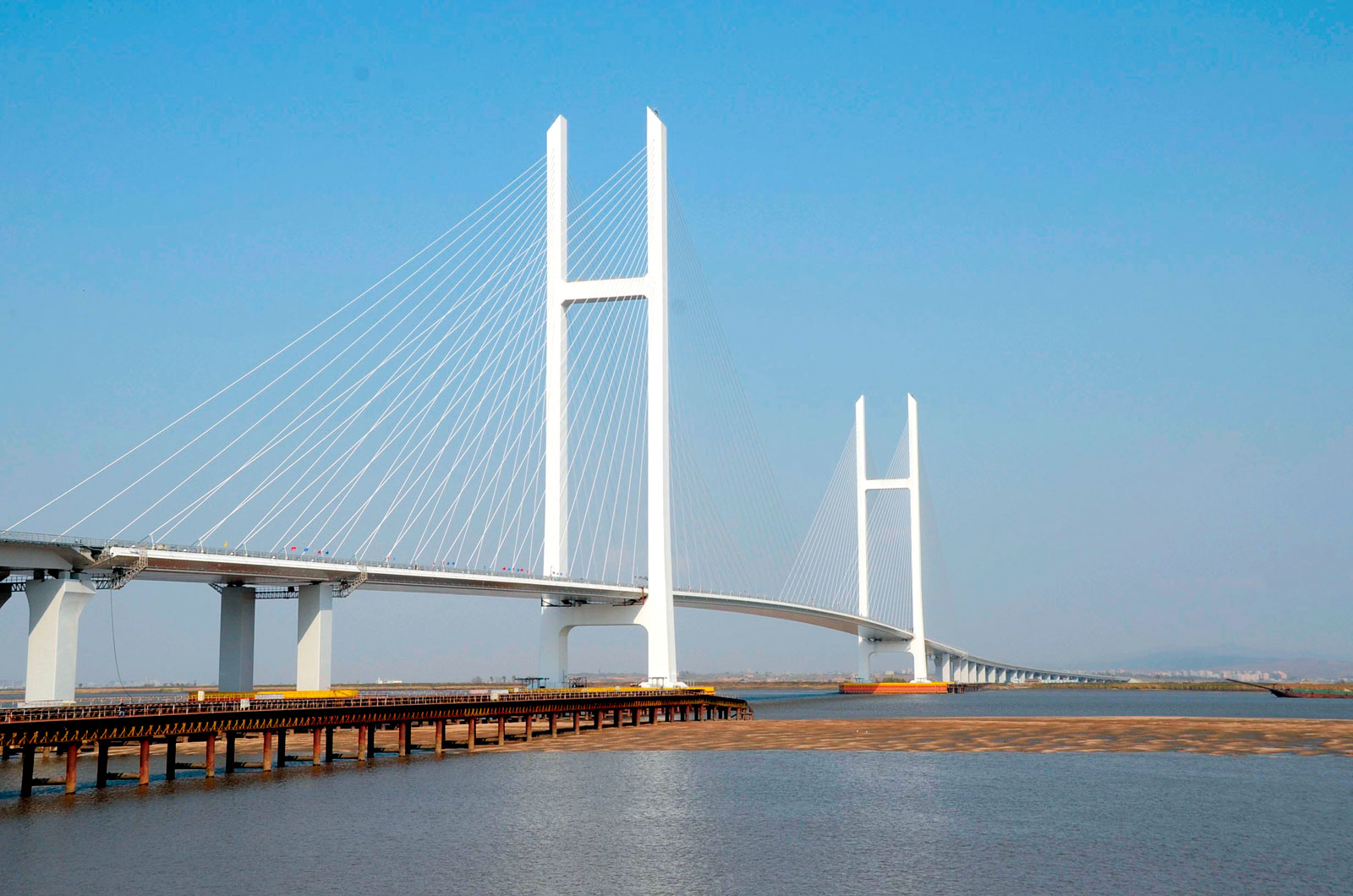
Die Neue eurasische Kontinentalbrücke (chinesisch 新亚欧大陆桥, Pinyin Xīn Yà-Ōu Dàlù Qiáo, englisch New Eurasian Continental Bridge), die auch Zweite eurasische Kontinentalbrücke (第二亚欧大陆桥, Dì'èr Yà-Ōu Dàlù Qiáo, englisch Second Eurasian Continental Bridge) genannt wird, ist eine 10.870 Kilometer[1] lange Eisenbahnverbindung, die Rotterdam in Europa mit der ostchinesischen Hafenstadt Lianyungang in der Provinz Jiangsu verbindet.
Sie besteht seit 1990 und führt durch die Dsungarische Pforte (Grenzbahnhof Alashankou). Die Lan-Xin-Bahn (chinesisch 兰新铁路, Pinyin Lán-Xīn Tiělù), also die Strecke von Lanzhou nach Ürümqi (in Xinjiang), ist ein Teil von ihr.
Es gibt eine nördliche, mittlere und südliche Route.[2] Die mittlere Strecke verläuft durch Kasachstan über Dostyk, Aqtogai, Astana, Samara, Smolensk, Brest, Warschau, Berlin zum Hafen von Rotterdam.[3] Vom slowakischen Košice soll auch eine Abzweigung in den Großraum Wien führen, siehe Breitspurstrecke Košice–Wien.
亚欧大陆桥,或新世纪亚欧大陆桥,是在中国大陆的新闻报道中经常出现的一个词语,特指从中国东部的沿海港口(有时特指连云港),沿陇海铁路、兰新铁路、北疆铁路,通过中亚、西亚到达欧洲的铁路路线。这条铁路在中国境外的具体走向,并没有任何官方文件精确指明,一说是经哈萨克斯坦、乌兹别克斯坦、土库曼斯坦、伊朗到达土耳其;一说是经俄罗斯、白俄罗斯、波兰、德国到达荷兰鹿特丹。全长10,800.32公里,1990年9月12日贯通。
The New Eurasian Land Bridge, also called the Second or New Eurasian Continental Bridge, is the southern branch of the Eurasian Land Bridge rail links running through China. The Eurasian Land Bridge is the overland rail link between Asia and Europe.
Due to a break-of-gauge between standard gauge used in China and the Russian gauge used in the former Soviet Union countries, containers must be physically transferred from Chinese to Kazakh railway cars at Dostyk on the Chinese-Kazakh border and again at the Belarus-Poland border where the standard gauge used in western Europe begins. This is done with truck-mounted cranes.[1] Chinese media often states that the New Eurasian Land/Continental Bridge extends from Lianyungang to Rotterdam, a distance of 11,870 kilometres (7,380 mi). The exact route used to connect the two cities is not always specified in Chinese media reports, but appears to usually refer to the route which passes through Kazakhstan.
All rail freight from China across the Eurasian Land Bridge must pass north of the Caspian Sea through Russia at some point. A proposed alternative would pass through Turkey and Bulgaria,[2] but any route south of the Caspian Sea must pass through Iran.[1]
Kazakhstan's President Nursultan Nazarbayev urged Eurasian and Chinese leaders at the 18th Shanghai Cooperation Organisation to construct the Eurasian high-speed railway (EHSRW) following a Beijing-Astana-Moscow-Berlin.[3]
The Eurasian Land Bridge (Russian: Евразийский сухопутный мост, Yevraziyskiy sukhoputniy most), sometimes called the New Silk Road (Новый шёлковый путь, Noviy shyolkoviy put'), or Belt and Road Initiative is the rail transport route for moving freight and passengers overland between Pacific seaports in the Russian Far East and China and seaports in Europe. The route, a transcontinental railroad and rail land bridge, currently comprises the Trans-Siberian Railway, which runs through Russia and is sometimes called the Northern East-West Corridor, and the New Eurasian Land Bridge or Second Eurasian Continental Bridge, running through China and Kazakhstan. As of November 2007, about 1% of the $600 billion in goods shipped from Asia to Europe each year were delivered by inland transport routes.[1]
Completed in 1916, the Trans-Siberian connects Moscow with Russian Pacific seaports such as Vladivostok. From the 1960s until the early 1990s the railway served as the primary land bridge between Asia and Europe, until several factors caused the use of the railway for transcontinental freight to dwindle. One factor is that the railways of the former Soviet Union use a wider rail gauge than most of the rest of Europe as well as China. Recently, however, the Trans-Siberian has regained ground as a viable land route between the two continents.[why?]
China's rail system had long linked to the Trans-Siberian via northeastern China and Mongolia. In 1990 China added a link between its rail system and the Trans-Siberian via Kazakhstan. China calls its uninterrupted rail link between the port city of Lianyungang and Kazakhstan the New Eurasian Land Bridge or Second Eurasian Continental Bridge. In addition to Kazakhstan, the railways connect with other countries in Central Asia and the Middle East, including Iran. With the October 2013 completion of the rail link across the Bosphorus under the Marmaray project the New Eurasian Land Bridge now theoretically connects to Europe via Central and South Asia.
Proposed expansion of the Eurasian Land Bridge includes construction of a railway across Kazakhstan that is the same gauge as Chinese railways, rail links to India, Burma, Thailand, Malaysia and elsewhere in Southeast Asia, construction of a rail tunnel and highway bridge across the Bering Strait to connect the Trans-Siberian to the North American rail system, and construction of a rail tunnel between South Korea and Japan. The United Nations has proposed further expansion of the Eurasian Land Bridge, including the Trans-Asian Railway project.
El Nuevo Puente de Tierra de Eurasia es también llamado el Segundo o Nuevo Puente Continental de Eurasia. Es la rama meridional de las conexiones ferroviarias del Puente de Tierra de Eurasia (también conocido como "Nueva Ruta de la Seda") que se extienden a través de la República Popular China, atravesando Kazajistán, Rusia y Bielorrusia. El Puente de Tierra de Eurasia es el enlace ferroviario terrestre entre Asia Oriental y Europa.
La Nueva Ruta de la Seda (en ruso, Новый шёлковый путь, Noviy shyolkoviy put), o Puente Terrestre Euroasiático, es la ruta de transporte ferroviario para el movimiento de tren de mercancías y tren de pasajeros por tierra entre los puertos del Pacífico, en el Lejano Oriente ruso y chino y los puertos marítimos en Europa.
La ruta, un ferrocarril transcontinental y puente terrestre, actualmente comprende el ferrocarril Transiberiano, que se extiende a través de Rusia, y el nuevo puente de tierra de Eurasia o segundo puente continental de Eurasia, que discurre a través de China y Kazajistán, también se van a construir carreteras entre las ciudades de la ruta. A partir de noviembre de 2007, aproximadamente el 1% de los 600 millones de dólares en bienes enviados desde Asia a Europa cada año se entregaron por vías de transporte terrestre.1
Terminado en 1916, el tren Transiberiano conecta Moscú con el lejano puerto de Vladivostok en el océano Pacífico, el más largo del mundo en el Lejano Oriente e importante puerto del Pacífico. Desde la década de 1960 hasta principios de 1990 el ferrocarril sirvió como el principal puente terrestre entre Asia y Europa, hasta que varios factores hicieron que el uso de la vía férrea transcontinental para el transporte de carga disminuyese.
Un factor es que los ferrocarriles de la Unión Soviética utilizan un ancho de vía más ancho en los rieles que la mayor parte del resto de Europa y China, y el transporte en barcos de carga por el canal de Suez en Egipto, construido por Inglaterra. El sistema ferroviario de China se une al Transiberiano en el noreste de China y Mongolia. En 1990 China añadió un enlace entre su sistema ferroviario y el Transiberiano a través de Kazajistán. China denomina a su enlace ferroviario ininterrumpido entre la ciudad portuaria de Lianyungang y Kazajistán como el «Puente terrestre de Nueva Eurasia» o «Segundo puente continental Euroasiático». Además de Kazajistán, los ferrocarriles conectan con otros países de Asia Central y Oriente Medio, incluyendo a Irán. Con la finalización en octubre de 2013 de la línea ferroviaria a través del Bósforo en el marco del proyecto Marmaray el puente de tierra de Nueva Eurasia conecta ahora teóricamente a Europa a través de Asia Central y del Sur.
La propuesta de ampliación del Puente Terrestre Euroasiático incluye la construcción de un ferrocarril a través de Kazajistán con el mismo ancho de vía que los ferrocarriles chinos, enlaces ferroviarios a la India, Birmania, Tailandia, Malasia y otros países del sudeste asiático, la construcción de un túnel ferroviario y un puente de carretera a través del estrecho de Bering para conectar el Transiberiano al sistema ferroviario de América del Norte, y la construcción de un túnel ferroviario entre Corea del Sur y Japón. Las Naciones Unidas ha propuesto una mayor expansión del Puente Terrestre Euroasiático, incluyendo el proyecto del ferrocarril transasiático.
Новый шёлковый путь (Евразийский сухопутный мост — концепция новой паневразийской (в перспективе — межконтинентальной) транспортной системы, продвигаемой Китаем, в сотрудничестве с Казахстаном, Россией и другими странами, для перемещения грузов и пассажиров по суше из Китая в страны Европы. Транспортный маршрут включает трансконтинентальную железную дорогу — Транссибирскую магистраль, которая проходит через Россию и второй Евразийский континентальный мост[en], проходящий через Казахстан[1]. Поезда по этому самому длинному в мире грузовому железнодорожному маршруту из Китая в Германию будут идти 15 дней, что в 2 раза быстрее, чем по морскому маршруту через Суэцкий канал[2].
Идея Нового шёлкового пути основывается на историческом примере древнего Великого шёлкового пути, действовавшего со II в. до н. э. и бывшего одним из важнейших торговых маршрутов в древности и в средние века. Современный НШП является важнейшей частью стратегии развития Китая в современном мире — Новый шёлковый путь не только должен выстроить самые удобные и быстрые транзитные маршруты через центр Евразии, но и усилить экономическое развитие внутренних регионов Китая и соседних стран, а также создать новые рынки для китайских товаров (по состоянию на ноябрь 2007 года, около 1 % от товаров на 600 млрд долл. из Азии в Европу ежегодно доставлялись наземным транспортом[3]).
Китай продвигает проект «Нового шёлкового пути» не просто как возрождение древнего Шёлкового пути, транспортного маршрута между Востоком и Западом, но как масштабное преобразование всей торгово-экономической модели Евразии, и в первую очередь — Центральной и Средней Азии. Китайцы называют эту концепцию — «один пояс — один путь». Она включает в себя множество инфраструктурных проектов, которые должны в итоге опоясать всю планету. Проект всемирной системы транспортных коридоров соединяет Австралию и Индонезию, всю Центральную и Восточную Азию, Ближний Восток, Европу, Африку и через Латинскую Америку выходит к США. Среди проектов в рамках НШП планируются железные дороги и шоссе, морские и воздушные пути, трубопроводы и линии электропередач, и вся сопутствующая инфраструктура. По самым скромным оценкам, НШП втянет в свою орбиту 4,4 миллиарда человек — более половины населения Земли[4].
Предполагаемое расширение Евразийского сухопутного моста включает в себя строительство железнодорожных путей от трансконтинентальных линий в Иран, Индию, Мьянму, Таиланд, Пакистан, Непал, Афганистан и Малайзию, в другие регионы Юго-Восточной Азии и Закавказья (Азербайджан, Грузия). Маршрут включает тоннель Мармарай под проливом Босфор, паромные переправы через Каспийское море (Азербайджан-Иран-Туркменистан-Казахстан) и коридор Север-Юг.Организация Объединенных Наций предложила дальнейшее расширение Евразийского сухопутного моста, в том числе проекта Трансазиатской железной дороги (фактически существует уже в 2 вариантах).
Для развития инфраструктурных проектов в странах вдоль Нового шёлкового пути и Морского Шёлкового пути и с целью содействия сбыту китайской продукции в декабре 2014 года был создан инвестиционный Фонд Шёлкового пути[5].
8 мая 2015 года было подписано совместное заявление Президента РФ В. Путина и Председателя КНР Си Цзиньпина о сотрудничестве России и Китая, в рамках ЕАЭС и трансевразийского торгово-инфраструктурного проекта экономического пояса «Шёлковый путь». 13 июня 2015 года был запущен самый длинный в мире грузовой железнодорожный маршрут Харбин — Гамбург (Германия), через территорию России.
 Eat and Drink
 Holidays
 Vacation and Travel

 Financial
 Economy and trade

 Musical instrument
 Life and Style
 Music
Music

 Party and government
 Hand in Hand
 Geography
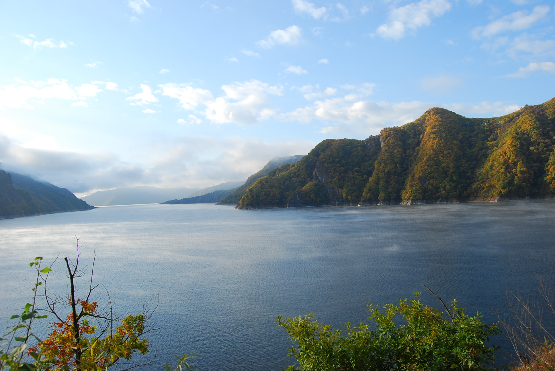
Der Yalu (deutsch auch Jalu, in Nordkorea Amnokkang genannt) ist ein Grenzfluss zwischen der Volksrepublik China und Nordkorea.
Er entspringt auf 2500 m Seehöhe am Paektu-san im Changbai-Gebirge und fließt nach 813 km zwischen den Städten Dandong (China) und Sinŭiju (Nordkorea) in das Gelbe Meer. Die wichtigsten Zuflüsse des Yalu sind der Changjin-gang, der Hŏch’ŏn-gang und der Tongro-gang.
In Sup’ung-Rodongjagu (水豊勞動者區) am Yalu, stromaufwärts von Sinŭiju, wurde die Supung-Talsperre mit einem der größten asiatischen Wasserkraftwerke errichtet. Die Staumauer ist 160 m hoch und über 850 m lang. Da das Kraftwerk in einem Grenzfluss gebaut wurde, wird es von beiden Staaten gemeinsam betrieben. Der Unterlauf des Yalu ist schiffbar. Im Bereich der Mündung des Yalu befinden sich u. a. die Inseln Hwanggŭmp’yŏng und Pidan-sŏm.
鸭绿江(朝鲜语:압록강/鴨綠江 Amnokkang */?满语:ᠶᠠᠯᡠ ᡠᠯᠠ Yalu ula;汉语拼音:Yālù jiāng),是位于中华人民共和国和朝鲜民主主义人民共和国之间的一条界江。入海口地区,朝方岛屿——绸缎岛和薪岛等与中方陆地接壤,因此鸭绿江江面末段完全在朝方一侧。目前河口为双方共用。 古称?水,汉朝称为马訾水,唐朝始称鸭绿江(隋唐时期?水为大同江),因其江水清澈,关于鸭绿江其名的来历主要流行着两种说法:一说因江水颜色似鸭头之色而得名(唐朝杜佑《通典》);二说因上游地区有鸭江和绿江两条支流汇入,故合而为一,并称为“鸭绿江”。另有源自于满族先民的语言(满语称为Yalu ula,意为“边界之江”)的说法。史书记载建州卫女真常年生活在婆猪江畔(鸭绿江支流)。鸭绿江发源于中国吉林省东南,中朝边境长白山主峰南麓海拔2300米处的长白山天池,然后流向西南,流经吉林省的长白朝鲜族自治县、临江市、集安市、辽宁省的丹东市,在辽宁省丹东市东港附近入黄海北部的西朝鲜湾。鸭绿江入海口是中国大陆海岸线的最北端。全长795公里,其中流经吉林省境界长575公里,辽宁省220公里;流域面积6.19万平方公里,中国境内流域面积约为3.25万平方公里。
鴨緑江(おうりょくこう、おうりょっこう、北京語:Yālù Jiāng、満州語:ᠶᠠᠯᡠ
ᡤᡳᠶᠠᠩ、 転写:yalu giyang[2]、朝鮮語:압록강)は、中華人民共和国(中国)東北部と朝鮮民主主義人民共和国(北朝鮮)との国境となっている川である。白頭山(中国名:長白山)に源を発し黄海に注ぐ。水の色が鴨の頭の色に似ていると言われたことからこの名前がある。
北岸は中国吉林省・遼寧省、南岸は北朝鮮慈江道・両江道・平安北道となっている。川沿いの主な都市としては、中国側に臨江、集安、丹東があり、北朝鮮側に慈城、満浦、楚山、新義州がある。
主な支流は赴戦江、長津江、虚川江で、いずれも北朝鮮側の蓋馬高原から北流して鴨緑江に合流しており、日本統治時代に大型ダムが建設されている。中国側からの支流には愛河などがある。
鴨緑江に架けられている橋の中では、下流の新義州と丹東を結ぶ中朝友誼橋が最もよく知られている。
流域では林業が盛んで、かつては上流部で伐採された木材を筏にして流していた。1930年代後半から1940年代初頭にかけて、日本によって中流域に竣工当時アジア最大級の水豊ダムが建設され、水力発電が行われるようになった。ここで生産される電力は、現在でも北朝鮮の重要なエネルギー源となっている。
The Yalu River, also called by Koreans the Amrok River or Amnok River, is a river on the border between North Korea and China. Together with the Tumen River to its east, and a small portion of Paektu Mountain, the Yalu forms the border between North Korea and China.
Two theories are given regarding the origin of the river's name. One theory is that the name derived from Yalu ula (ᠶᠠᠯᡠ
ᡠᠯᠠ) in the Manchu language. The Manchu word yalu (ᠶᠠᠯᡠ) means "the boundary between two countries". In Mandarin Chinese, yālù phonetically approximates the original Manchu word, but literally means "duck green", which was said to have been once the color of the river. The other theory is that the river was named after the combination of its two upper branches, which were called "鴨" (Yā or Ap) and "綠" (Lù or R(or n)ok)", respectively.
Revised Romanization of Korean spelled it Amnokgang (Korean pronunciation: [amnok.k͈aŋ]; "Amnok River") and Revised Romanization of Hangeul spelled it Aprokgang (Korean pronunciation: [amnok.k͈aŋ]; "Aprok River").
From 2500 m above sea level on Paektu Mountain on the China–North Korea border, the river flows south to Hyesan before sweeping 130 km northwest to Linjiang and then returning to a more southerly route for a further 300 km to empty into the Korea Bay between Dandong (China) and Sinuiju (North Korea). The bordering Chinese provinces are Jilin and Liaoning.
The river is 795 kilometers (494 mi) long and receives water from over 30,000 km² of land. The Yalu's most significant tributaries are the Changjin (장진강; 長津江), the Hochon (허천강; 虛川江), the Togro (독로강; 禿魯江) rivers from Korea and the Ai (or Aihe) (璦河) and the Hun (浑江) from China. The river is not easily navigable for most of its length.[1] Most of the river freezes during winter and can be crossed on foot.[2]
The depth of the Yalu River varies from some of the more shallow parts on the eastern side in Hyesan (1 meter (3 ft 3 in)) to the deeper parts of the river near the Yellow Sea (2.5 meters (8 ft 2 in)).[3] The estuary is the site of the Amrok River estuary Important Bird Area, identified as such by BirdLife International.[4]
About 205 islands are on the Yalu. A 1962 border treaty between North Korea and China split the islands according to which ethnic group was living on each island. North Korea possesses 127 and China 78. Due to the division criteria, some islands such as Hwanggumpyong Island belong to North Korea, but abut the Chinese side of the river.
Le Yalu (chinois simplifié : 鸭绿江 ; chinois traditionnel : 鴨綠江 ; pinyin : ), ou Amnok (en coréen : 압록강), est un fleuve qui marque la frontière entre la Chine et la Corée du Nord.
Il naît sur le Mont Paektu, point culminant de toute la Corée, à 2 500 m d'altitude et se jette dans la mer Jaune, après un parcours de 800 km orienté globalement vers le Sud-Ouest. Son bassin versant a une superficie de 30 000 km2.
Ses principaux affluents sont le Hunjiang (446 km), le Pushi et le Ai He (182 km) côté chinois ainsi que le Changjin, le Hochon et le Tongro côté coréen.
Trois barrages servent à l'approvisionnement en électricité : les barrages de Supung (765 MW), Yunfeng (400 MW) et Taipingwan.
Plusieurs ponts permettent de franchir le fleuve, dont les plus importants sont le Pont cassé du Yalu, détruit par les Américains pendant la Guerre de Corée et le pont de l'amitié sino-coréenne, qui lui est parallèle.
Il fiume Yalu (in cinese: 鴨綠江T, 鸭绿江S, Yālù JiāngP) o, in coreano, fiume Amnok (압록강?, 鴨綠江?, AmnokkangMR) forma parte del confine fra la Cina e la Corea del Nord. I due nomi in cinese e coreano sono le diverse pronunce degli stessi caratteri cinesi rappresentanti la parola Yalu ula in mancese. La sorgente si trova a circa 2500 m sul mare sulla montagna Baitou nei monti Changbai. Dopo circa 800 km il fiume sfocia nella Baia di Corea fra le città di Dandong in Cina e Sinŭiju nella Corea del Nord. Il bacino dello Yalu misura circa 39,800 km²[1].
El río Yalu o Yalú (en chino, 鸭绿江; Amrok-gang en Corea del Norte y Amnok-gang en Corea del Sur,압록강) es un río fronterizo entre China y Corea del Norte. El nombre chino proviene de una palabra manchú que significa «el límite entre dos campos».
Nace a 2500 metros sobre el nivel del mar en Paektu-san en las montañas de Changbai y fluye a lo largo de aproximadamente 800 kilómetros (según las fuentes, entre 813 y 790 km) desembocando entre las ciudades de Dandong (China) y Sinuiju (Corea del Norte), en el mar Amarillo. Los afluentes más importantes del Yalu son los ríos Changjin, Hŏch'ŏn y Tongro.
Ялуцзя́н (кит. 鸭绿江), Амноккан[1] (кор. 압록강?, 鴨綠江?, в старой русской географической литературе Амнокга́нг) — река на востоке Евразии, определяющая юго-западную часть границы между КНР и КНДР — на правом берегу располагается провинции КНР Ляонин и Гирин, на левом — провинции КНДР Пхёнан-Пукто и Чагандо.
 Animal world


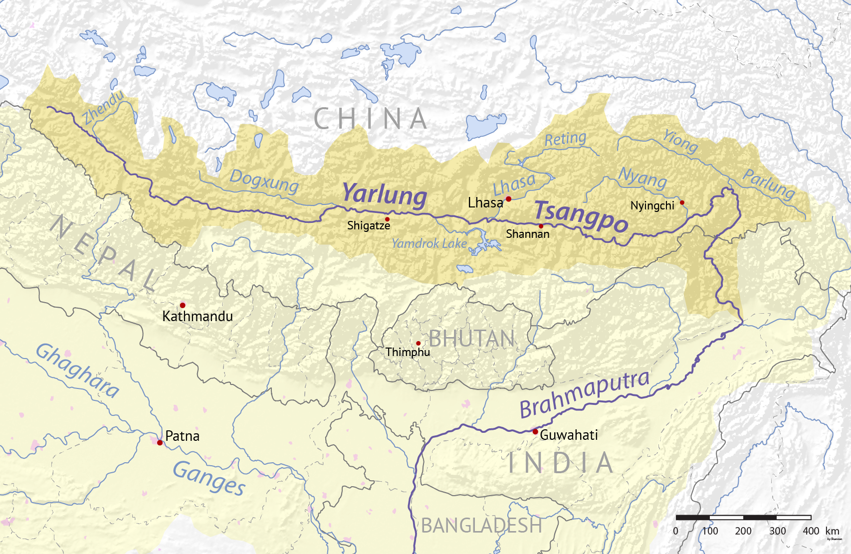
布拉馬普特拉河(Deori:Ji Chima或Chima jima,直译:母親河;梵語:ब्रह्मपुत्र,羅馬化:Brahmaputra,直译:梵天之子);《新唐書》 譯迦羅都河,南亚的一条重要国际河流。以水量、长度来说,此河是南亚第一大河。它也是以流量計世界第九大河及以長度計世界第十五大河。
雅鲁藏布江的上游在中国境内,称为雅鲁藏布江,长2057公里;流入印度后称为布拉马普特拉河,长644公里;流入孟加拉国后称贾木纳河,长240公里;在阿里恰与恒河汇流后称帕德玛河,长100公里;在琴德普尔与梅格纳河汇合后仍称梅格纳河长241公里;最后注入孟加拉湾。包括上游雅鲁藏布江在内的全长为2900公里。总流域面积712,035平方公里。流域国有中国、印度、不丹、孟加拉国,四国分别占该河流域面积的51.1%、34%、6.7%、8.2%。
Der Yarlung Tsangpo, auch Yarlung Zangbo (tibetisch: ཡར་ཀླུངས་གཙང་པོ་, Wylie: yar kLungs gTsang po, ZYPY: Yarlung Zangbo) und Yalu Zangbu River (chinesisch: 雅鲁藏布江; pinyin: Yǎlǔzàngbù Jiāng) ist der Oberlauf des Brahmaputra in der Autonomen Region Tibet, China. Er ist der längste Fluss Tibets und der fünftlängste in China. Der obere Abschnitt wird auch Dangque Zangbu genannt, was "Pferdefluss" bedeutet.
Der Brahmaputra (Sanskrit für „Sohn des Brahma“) ist der Hauptstrang des als Meghna in den Indischen Ozean mündenden wasserreichsten Stromes in Asien. Sein in Tibet gelegener Oberlauf Yarlung Tsangpo gilt mit einer mittleren Höhenlage von 4000 Metern als der am höchsten verlaufende Fluss der Welt.[4]
Als einer der längsten Flüsse der Erde fließt er mit einer Länge von rund 3100 Kilometern bis zum Zusammenfluss mit dem Ganges durch das Gebiet der Staaten China, Indien und Bangladesch. Sein Lauf ist teils veränderlich, teils schwer zugänglich und quert mehrere Kulturräume, was zu vielen unterschiedlichen Namen einzelner Teilabschnitte geführt hat.
Egypt
Australia
Belgium
Brunei Darussalam
China
Germany
Djibouti
France
Greece
Guangdong Sheng-GD
Hongkong Tebiexingzhengqu-HK
India
Indonesia

 IT-Times
 Late Classical, Romantic (Early, Middle, Late)
Italy
Japan
Malaysia
Morocco
Myanmar
Oman
Pakistan
Philippines
Portugal
Republic of Korea
Saudi Arabia
Shanghai Shi-SH
Singapore
Singapore
Sri Lanka
Taiwan Sheng-TW
Thailand
Turkey
United Arab Emirates
United Kingdom
Vietnam
Cyprus
Late Classical, Romantic (Early, Middle, Late)
Italy
Japan
Malaysia
Morocco
Myanmar
Oman
Pakistan
Philippines
Portugal
Republic of Korea
Saudi Arabia
Shanghai Shi-SH
Singapore
Singapore
Sri Lanka
Taiwan Sheng-TW
Thailand
Turkey
United Arab Emirates
United Kingdom
Vietnam
Cyprus
